Перевод «арарат» на армянский
Արարատ, Մասիս, Արարատի մարզ — самые популярные переводы слова «арарат» на армянский.
Пример переведенного предложения: Это одна из причин, почему армяне связывают свою страну с горой Арарат. ↔ Սա պատճառներից մեկն է, թե ինչու են հայերը իրենց երկիրը կապում Արարատ լեռան հետ։
Арарат
proper
существительное мужского рода
masculine
грамматика
Арарат (марз) [..]
-
Это одна из причин, почему армяне связывают свою страну с горой Арарат.
Սա պատճառներից մեկն է, թե ինչու են հայերը իրենց երկիրը կապում Արարատ լեռան հետ։
-
Արարատի մարզ
Это одна из причин, почему армяне связывают свою страну с горой Арарат.
Սա պատճառներից մեկն է, թե ինչու են հայերը իրենց երկիրը կապում Արարատ լեռան հետ։
37 Однажды, когда он кланялся своему богу+ Нисро́ху в доме этого бога+, его сыновья Адрамеле́х и Шареце́р убили его мечом+ и убежали в землю Арарат+.
37 Մի անգամ, երբ նա իր աստծու+՝ Նեսրոքի+ տանը խոնարհվում էր նրա առաջ, նրա որդիներ Ադրամելեքն ու Սարասարը սրով սպանեցին նրան+ ու փախան Արարատի+ երկիր։
Подобное произошло в Финляндии в 1915 году, когда кто-то из братьев основал кооператив «Арарат» и со страниц финского издания «Сторожевой башни» приглашал в нем работать.
Այդպիսի բան տեղի ունեցավ Ֆինլանդիայում 1915թ.-ին, երբ մի քանի եղբայրներ հիմնեցին «Արարատ» կոոպերատիվ ընկերությունը եւ «Դիտարան» պարբերագրի ֆիններեն հրատարակության միջոցով սկսեցին հրավիրել ընթերցողներին աշխատելու իրենց կոոպերատիվում։
Они убеждены, что фрагменты ковчега все еще лежат на горе Арарат, большую часть года погребенные под толщей льда и снега.
Նրանք կարծում են, թե տապանի մնացորդները դեռ ձյունածածկ Արարատ լեռան վրա են, լեռ, որը տարվա մեծ մասը ձյան եւ սառույցի տակ է։
В ней лишь вскользь упоминаются «горы Арарат».
Այնտեղ միայն ասվում է, որ «տապանը նստեց Արարատ լեռների վրա»։
Далее сообщается, что воды покрывали землю 150 дней и что «в седьмом месяце, в семнадцатый день месяца, ковчег остановился на горах Арарат» (Бытие 7:11, 24; 8:4).
Այնուհետեւ նշվում է, որ երկիրը 150 օր մնաց ջրի տակ, որից հետո «յոթերորդ ամսում՝ ամսվա տասնյոթերորդ օրը, տապանը նստեց Արարատի լեռների վրա» (Ծննդոց 7։
«Ковчег остановился на горах Арарат» (Бытие 8:4).
«Տապանը նստեց Արարատի լեռների վրա» (Ծննդոց 8։ 4)։
Дело в том, что одно из предполагаемых мест, где покоится ковчег, находится на склоне горы Арарат на высоте около 4 600 метров над уровнем моря.
Նախ այն տեղը, որտեղ իբրեւ թե գտնվում է տապանը, մոտավորապես 4 600 մետր բարձրության վրա է։
Однако в 1915 году в поисках средств брат Хартева и другие основали кооператив «Арарат» и стали издавать журнал с таким же названием.
Սակայն 1915-ին եղբայր Հարթեւան միջոցներ գտնելու համար մի քանի եղբայրների հետ հիմնեց կոոպերատիվ ընկերություն, որը կոչեցին «Արարատ» եւ սկսեցին այդ անունը կրող ամսագիր հրատարակել։
И в один прекрасный день ковчег мягко остановился «на горах Арарат», расположенных на территории современной Турции.
Վերջապես ջրերը սկսեցին նվազել, եւ մի օր տապանը նստեց «Արարատի լեռների վրա»։
38 Однажды, когда он кланялся своему богу+ Нисро́ху+ в доме этого бога, его сыновья Адрамеле́х и Шареце́р убили его мечом+ и убежали в землю Арарат+.
38 Մի անգամ, երբ նա իր աստծու+՝ Նեսրոքի+ տանը խոնարհվում էր նրա առաջ, նրա որդիներ Ադրամելեքն ու Սարասարը սրով սպանեցին+ նրան ու փախան Արարատի+ երկիր։
В «Арарате» он опубликовал письмо брата Расселла, а также свой ответ на него.
Նա «Արարատ» ամսագրում հրատարակեց եղբայր Ռասելի նամակը եւ իր պատասխան նամակը։
Абрикосы Бренди Арарат «Абрикон»: благородная элегантность (рус.) // Спиртные напитки и пиво : Журнал. — Март-Медиа, 2012. — Вып.
Արարատի պատկերը եղել է ինչպես Հայկական ԽՍՀ զինանշանի, այնպես էլ առկա է անկախ Հայաստանի զինանշանի վրա։ «Абрикон»: благородная элегантность(ռուս.) // Спиртные напитки и пиво : Журнал. — Март-Медиа, 2012. — В. 5.
4 В седьмом месяце, в семнадцатый день месяца, ковчег+ остановился на горах Арарат+.
4 Յոթերորդ ամսում՝ ամսվա տասնյոթերորդ օրը, տապանը+ նստեց Արարատի+ լեռների վրա։
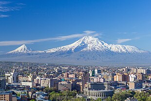
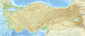
Сегодня гора Арарат находится на территории Турции, у ее восточной границы.
Այժմ Արարատ լեռը գտնվում է Թուրքիայում՝ նրա արեւելյան սահմանի մոտ։
Например, иудейский историк первого века Иосиф Флавий ссылался на высказывания более ранних историков, во времена которых ковчег все еще был виден высоко в горах Арарат.
Օրինակ՝ մ.թ. առաջին դարի հրեա պատմաբան Հովսեպոսը խոսում է ավելի վաղ շրջանում ապրած որոշ պատմաբանների մասին, որոնք իրենց աշխատություններում նշել են, թե Արարատի լեռնաշղթայում տապանը դեռեւս տեսանելի է։
Согласно Библии, Ноев ковчег «остановился на горах Арарат» (Бытие 8:4). Горный массив Арарат расположен на востоке Турции, близ границы с Арменией и Ираном, и включает в себя знаменитую гору Арарат.
4, ՆԱ)։ Արարատի շրջանը, որտեղ ամենաբարձր գագաթը Արարատ լեռն է, գտնվում է Թուրքիայի արեւելքում՝ Հայաստանի եւ Իրանի սահմանների մոտ։
Созовите против него царства Арарат+, Ми́ни и Аскена́з+.
Արարատի+, Միննիի ու Ասքանազի+ թագավորությունները նրա դեմ կանչեք։
| Mount Ararat | |
|---|---|
|
|
| Highest point | |
| Elevation | 5,137 m (16,854 ft) See Elevation section |
| Prominence | 3,611 m (11,847 ft)[1] Ranked 48th |
| Isolation | 379 km (235 mi) |
| Listing | Country high point Ultra Volcanic Seven Second Summits |
| Coordinates | 39°42′07″N 44°17′54″E / 39.70194°N 44.29833°ECoordinates: 39°42′07″N 44°17′54″E / 39.70194°N 44.29833°E |
| Geography | |
|
Mount Ararat Location in Turkey
Mount Ararat Mount Ararat (Armenia)
Mount Ararat Mount Ararat (Near East)
Mount Ararat Mount Ararat (Earth) |
|
| Location | Iğdır and Ağrı provinces, Turkey |
| Region | Eastern Anatolia Region |
| Parent range | Armenian Highlands |
| Geology | |
| Mountain type | Stratovolcano |
| Last eruption | July 2, 1840 |
| Climbing | |
| First ascent | 9 October [O.S. 27 September] 1829 Friedrich Parrot, Khachatur Abovian, two Russian soldiers, two Armenian villagers |


| Designations | |
|---|---|
|
IUCN Category II (National Park) |
|
| Official name | Ağrı Dağı Milli Parkı |
| Designated | 1 November 2004[2] |
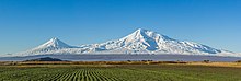
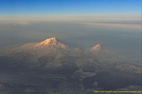
Mount Ararat[a] is a snow-capped and dormant compound volcano in the extreme east of Turkey. It consists of two major volcanic cones: Greater Ararat and Little Ararat. Greater Ararat is the highest peak in Turkey and the Armenian Highland with an elevation of 5,137 m (16,854 ft); Little Ararat’s elevation is 3,896 m (12,782 ft).[3] The Ararat massif is about 35 km (22 mi) wide at ground base.[4] The first recorded efforts to reach Ararat’s summit were made in the Middle Ages, and Friedrich Parrot, Khachatur Abovian, and four others made the first recorded ascent in 1829.
In Europe, the mountain has been called by the name Ararat since the Middle Ages, as it began to be identified with «mountains of Ararat» described in the Bible as the resting place of Noah’s Ark, despite contention that Genesis 8:4 does not refer specifically to a Mount Ararat.
Despite lying outside the borders of modern Armenia, the mountain is the principal national symbol of Armenia and has been considered a sacred mountain by Armenians. It is featured prominently in Armenian literature and art and is an icon for Armenian irredentism. It is depicted on the coat of arms of Armenia along with Noah’s Ark.
Political borders[edit]
Mount Ararat forms a near-quadripoint between Turkey, Armenia, Iran, and the Nakhchivan exclave of Azerbaijan. Its summit is located some 16 km (10 mi) west of both the Iranian border and the border of the Nakhchivan exclave of Azerbaijan, and 32 km (20 mi) south of the Armenian border. The Turkish–Armenian–Azerbaijani and Turkish–Iranian–Azerbaijani tripoints are some 8 km apart, separated by a narrow strip of Turkish territory containing the E99 road which enters Nakhchivan at 39°39′19″N 44°48′12″E / 39.6553°N 44.8034°E.
From the 16th century until 1828 the range was part of the Ottoman-Persian border; Great Ararat’s summit and the northern slopes, along with the eastern slopes of Little Ararat were controlled by Persia. Following the 1826–28 Russo-Persian War and the Treaty of Turkmenchay, the Persian controlled territory was ceded to the Russian Empire. Little Ararat became the point where the Turkish, Persian, and Russian imperial frontiers converged.[5] The current international boundaries were formed throughout the 20th century. The mountain came under Turkish control during the 1920 Turkish–Armenian War.[6] It formally became part of Turkey according to the 1921 Treaty of Moscow and Treaty of Kars.[7] In the late 1920s, Turkey crossed the Iranian border and occupied the eastern flank of Lesser Ararat as part of its effort to quash the Kurdish Ararat rebellion,[8] during which the Kurdish rebels used the area as a safe haven against the Turkish state.[9] Iran eventually agreed to cede the area to Turkey in a territorial exchange.[8][10] The Iran-Turkey boundary skirts east of Lesser Ararat, the lower peak of the Ararat massif.
As of 2004 the mountain is open to climbers only with «military permission». The procedure to obtain the permission involves submitting a formal request to a Turkish embassy for a special «Ararat visa», and it is mandatory to hire an official guide from the Turkish Federation for Alpinism. Access is still limited, even for climbers who obtain the necessary permission, and those who venture off the approved path may be fired upon without warning.[11]
Names and etymology[edit]
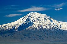
Closeup of Greater Ararat


Ararat[edit]
Ararat (Western Armenian pronunciation: Ararad) is the Biblical Hebrew name (אררט ʾrrṭ; Tiberian vocalization אֲרָרָט ʾărārāṭ; Pesher Genesis הוררט hōrārāṭ),[12] cognate with Assyrian Urartu,[13] of a kingdom that existed in the Armenian Highlands in the 9th–6th centuries BC.
In the 19th century Wilhelm Gesenius speculated an origin from Arjanwartah, an unattested Sanskrit word without any clear cognates, supposedly meaning «holy ground.»[14][15] Some Armenian historians, such as Ashot Melkonyan, link the origin of the word «Ararat» to the prefix of a number of placenames in the Armenian Highland («ar–»), including the Armenians.[16][17] The mountain is known as Ararat in European languages,[18][19] however, none of the native peoples have traditionally referred to the mountain by that name.[20] This mountain was not called by the name Ararat until the Middle Ages; early Armenian historians considered the biblical Ararat to be in Corduene.[21][22]
Masis[edit]
The traditional Armenian name is Masis (Մասիս [maˈsis]; sometimes Massis).[23][20] However, nowadays, the terms Masis and Ararat are both widely, often interchangeably, used in Armenian.[24][b] The folk etymology expressed in Movses Khorenatsi’s History of Armenia derives the name from king Amasya, the great-grandson of the legendary Armenian patriarch Hayk, who is said to have called the mountain Masis after himself.[29][30]
Various etymologies have been proposed. Russian orientalist Anatoly Novoseltsev suggested that Masis derives from Middle Persian masist, «the largest.»[31] According to Armenian historian Sargis Petrosyan the mas root in Masis means «mountain», cf. Proto-Indo-European *mņs-.[30] According to archaeologist Armen Petrosyan, the name originates from the Māšu (Mashu) mountain mentioned in the Epic of Gilgamesh, which sounded like Māsu in Assyrian.[32] According to this theory, the name meant «twin,» referring to the twin peaks of the mountain. Erkuahi, a land mentioned in Urartian texts and identified with Mt. Ararat, could reflect the native Armenian-language form of this same name (compare to Armenian erku (երկու, meaning «two»)).[33]
Today, both Ararat and Masis are common male first names among Armenians.[34]
Ağrı and Agirî[edit]
The Turkish name is Ağrı Dağı[35] ([aːɾɯ da.ɯ]; Ottoman Turkish: اغـر طﺎﻍ Ağır Dağ), i.e. «Mountain of Ağrı». Ağrı literally translates to «pain» or «sorrow».[18][31][36][37] This name has been known since the late Middle Ages.[31] The 17th century explorer Evliya Çelebi referred to it as Ağrî in the Seyahatnâme.[38]
The Kurdish name of the mountain is Çiyayê Agirî[39][40] [t͡ʃɪjaːˈje aːgɪˈriː], which translates to «fiery mountain».[41] An alternative Kurdish name is Grîdax, which is composed of the word grî, presumably a corrupted version of the Kurdish girê, meaning hill, or Agirî, and dax, which is the Turkish dağ, meaning mountain.[42]
Despite the supposed meaning in Turkish Ağrı Dağı as «pain mountain» and Kurdish Çiyayê Agirî as «fiery mountain», some linguists underline a relationship between the mountain’s name and a village on its slopes called Ağori that was decimated after a landslide in 1840. The exact meaning of these related names remains unknown.[38]
Other names[edit]
The traditional Persian name is کوه نوح, [ˈkuːhe ˈnuːh], Kūh-e Nūḥ,[5] literally the «mountain of Noah».[18][23]
In classical antiquity, particularly in Strabo’s Geographica, the peaks of Ararat were known in ancient Greek as Ἄβος (Abos) and Νίβαρος (Nibaros).[c]
Geography[edit]
Mount Ararat is located in the Eastern Anatolia Region of Turkey between the provinces of Ağrı and Iğdır, near the border with Iran, Armenia and Nakhchivan exclave of Azerbaijan, between the Aras and Murat rivers.[47] The Serdarbulak lava plateau, at 2600 meters of elevation, separates the peaks of Greater and Little Ararat.[48] Mount Ararat’s summit is located some 16 km (10 mi) west of the Turkey-Iran border and 32 km (20 mi) south of the Turco-Armenian border. The Ararat plain runs along its northwest to western side.
Elevation[edit]
Ararat is the third most prominent mountain in West Asia.
An elevation of 5,165 m (16,946 ft) for Mount Ararat is given by some encyclopedias and reference works such as Merriam-Webster’s Geographical Dictionary and Encyclopedia of World Geography.[49][50][51][52] However, a number of sources, such as the United States Geological Survey and numerous topographic maps indicate that the alternatively widespread figure of 5,137 m (16,854 ft) is probably more accurate.[53][54] The current elevation may be as low as 5,125 m (16,814 ft) due to the melting of its snow-covered ice cap.[55]

Summit ice cap[edit]
The ice cap on the summit of Mount Ararat has been shrinking since at least 1957. In the late 1950s, Blumenthal observed that there existed 11 outlet glaciers emerging from a summit snow mass that covered about 10 km2 (3.9 sq mi).[56] At that time, it was found that the present glaciers on the summit of Ararat extend as low as an elevation of 3,900 meters (12,800 ft) on the north-facing slope, and an elevation of
4,200 meters (13,800 ft) on its south-facing slope.[56] Using pre-existing aerial imagery and remote sensing data, Sarıkaya and others studied the extent of the ice cap on Mount Ararat between 1976 and 2011.[39][57] They discovered that this ice cap had shrunk to 8.0 km2 (3.1 sq mi) by 1976 and to 5.7 km2 (2.2 sq mi) by 2011. They calculated that between 1976 and 2011, the ice cap on top of Mount Ararat had lost 29% of its total area at an average rate of ice loss of 0.07 km2 (0.027 sq mi) per year over 35 years. This rate is consistent with the general rates of retreat of other Turkish summit glaciers and ice caps that have been documented by other studies.[57] According to a 2020 study by Yalcin, «if the glacial withdrawals continue with the same acceleration, the permanent glacier will likely turn into a temporary glacier by 2065.»[58]
Blumenthal estimated that the snow line had been as low as 3,000 meters (9,800 ft) in elevation during the Late Pleistocene.[56] Such a snow line would have created an ice cap of 100 km2 (39 sq mi) in extent. However, he observed a lack of any clear evidence of prehistoric moraines other than those which were close to the 1958 glacier tongues. Blumenthal explained the absence of such moraines by the lack of confining ridges to control glaciers, insufficient debris load in the ice to form moraines, and their burial by later eruptions. Years later, Birman observed on the south-facing slopes a possible moraine that extends at least 300 meters (980 ft) in altitude below the base of the 1958 ice cap at an elevation of 4,200 meters (13,800 ft).[59] He also found two morainal deposits that were created by a Mount Ararat valley glacier of Pleistocene, possibly Wisconsinan (Last Glacial Maximum) age, downvalley from Lake Balık. The higher moraine lies at an altitude of about 2,200 meters (7,200 ft) and the lower moraine lies at an altitude of about 1,800 meters (5,900 ft). The lower moraine occurs about 15 kilometers (9.3 mi) downstream from Lake Balık. Both moraines are about 30 meters (98 ft) high. It is suspected that Lake Balık occupies a glacial basin.[59]
Geology[edit]
Mount Ararat is a polygenic, compound stratovolcano. Covering an area of 1,100 km2 (420 sq mi), it is the largest volcanic edifice within the region. Along its northwest–southeast trending long axis, Mount Ararat is about 45 kilometers (28 mi) long and is about 30 kilometers (19 mi) long along its short axis. It consists of about 1,150 km3 (280 cu mi) of dacitic and rhyolitic pyroclastic debris and dacitic, rhyolitic, and basaltic lavas.[3]
Mount Ararat consists of two distinct volcanic cones, Greater Ararat and Lesser Ararat (Little Ararat). The western volcanic cone, Greater Ararat, is a steep-sided volcanic cone that is larger and higher than the eastern volcanic cone. Greater Ararat is about 25 kilometers (16 mi) wide at the base and rises about 3 kilometers (1.9 mi) above the adjacent floors of the Iğdir and Doğubeyazıt basins. The eastern volcanic cone, Lesser Ararat, is 3,896 meters (12,782 ft) high and 15 kilometers (9.3 mi) across. These volcanic cones, which lie 13 kilometers (8.1 mi) apart, are separated by a wide north–south-trending crack. This crack is the surface expression of an extensional fault. Numerous parasitic cones and lava domes have been built by flank eruptions along this fault and on the flanks of both of the main volcanic cones.[3]
Mount Ararat lies within a complex, sinistral pull-apart basin that originally was a single, continuous depression. The growth of Mount Ararat partitioned this depression into two smaller basins, the Iğdir and Doğubeyazıt basins. This pull-apart basin is the result of strike-slip movement along two en-echelon fault segments, the Doğubeyazıt–Gürbulak and Iğdir Faults, of a sinistral strike–slip fault system. Tension between these faults not only formed the original pull-apart basin, but created a system of faults, exhibiting a horsetail splay pattern, that control the position of the principal volcanic eruption centers of Mount Ararat and associated linear belt of parasitic volcanic cones. The strike-slip fault system within which Mount Ararat is located is the result of north–south convergence and tectonic compression between the Arabian Platform and Laurasia that continued after the Tethys Ocean closed during the Eocene epoch along the Bitlis–Zagros suture.[3][60][61]
Geological history[edit]


Tectonic map of the Mediterranean and surrounding mountain ranges
During the early Eocene and early Miocene, the collision of the Arabian platform with Laurasia closed and eliminated the Tethys Ocean from the area of what is now Anatolia. The closure of these masses of continental crust collapsed this ocean basin by middle Eocene and resulted in a progressive shallowing of the remnant seas, until the end of the early Miocene. Post-collisional tectonic convergence within the collision zone resulted in the total elimination of the remaining seas from East Anatolia at the end of early Miocene, crustal shortening and thickening across the collision zone, and uplift of the East Anatolian–Iranian plateau. Accompanying this uplift was extensive deformation by faulting and folding, which resulted in the creation of numerous local basins. The north–south compressional deformation continues today as evidenced by ongoing faulting, volcanism, and seismicity.[3][60][62]
Within Anatolia, regional volcanism started in the middle-late Miocene. During the late Miocene–Pliocene period, widespread volcanism blanketed the entire East Anatolian–Iranian plateau under thick volcanic rocks. This volcanic activity has continued uninterrupted until historical times. Apparently, it reached a climax during the latest Miocene–Pliocene, 6 to 3 Ma. During the Quaternary, the volcanism became restricted to a few local volcanoes such as Mount Ararat. These volcanoes are typically associated with north–south tensional fractures formed by the continuing north–south shortening deformation of Anatolia.[3]
In their detailed study and summary of the Quaternary volcanism of Anatolia, Yilmaz et al. recognized four phases to the construction of Mount Ararat from volcanic rocks exposed in glacial valleys deeply carved into its flanks.[3] First, they recognized a fissure eruption phase of Plinian-subPlinian fissure eruptions that deposited more than 700 meters (2,300 ft) of pyroclastic rocks and a few basaltic lava flows. These volcanic rocks were erupted from approximately north northwest–south southeast-trending extensional faults and fissures prior to the development of Mount Ararat. Second, a cone-building phase began when the volcanic activity became localized at a point along a fissure. During this phase, the eruption of successive flows of lava up to 150 meters (490 ft) thick and pyroclastic flows of andesite and dacite composition and later eruption of basaltic lava flows, formed the Greater Ararat cone with a low conical profile. Third, during a climatic phase, copious flows of andesitic and basaltic lavas were erupted. During this phase, the current cones of Greater and Lesser Ararat were formed as eruptions along subsidiary fissures and cracks and flank occurred. Finally, the volcanic eruptions at Mount Ararat transitioned into a flank eruption phase, during which a major north–south-trending fault offset the two cones that developed along with a number of subsidiary fissures and cracks on the volcano’s flanks. Along this fault and the subsidiary fissures and cracks, a number of parasitic cones and domes were built by minor eruptions. One subsidiary cone erupted voluminous basalt and andesite lava flows. They flowed across the Doğubeyazıt plain and along the southerly flowing Sarısu River. These lava flows formed black ʻaʻā and pāhoehoe lava flows that contain well preserved lava tubes.[3] The radiometric dating of these lava flows yielded radiometric ages of 0.4, 0.48 and 0.81 Ma.[63] Overall, radiometric ages obtained from the volcanic rocks erupted by Mount Ararat range from 1.5 to 0.02 Ma.[3]
Recent volcanic and seismic activity[edit]
The chronology of Holocene volcanic activity associated with Mount Ararat is documented by either archaeological excavations, oral history, historical records, or a combination of these data, which provide evidence that volcanic eruptions of Mount Ararat occurred in 2500–2400 BC, 550 BC, possibly in 1450 AD and 1783 AD, and definitely in 1840 AD. Archaeological evidence demonstrates that explosive eruptions and pyroclastic flows from the northwest flank of Mount Ararat destroyed and buried at least one Kura–Araxes culture settlement and caused numerous fatalities in 2500–2400 BC. Oral histories indicated that a significant eruption of uncertain magnitude occurred in 550 BC and minor eruptions of uncertain nature might have occurred in 1450 AD and 1783 AD.[64][61][62][65] According to the interpretation of historical and archaeological data, strong earthquakes not associated with volcanic eruptions also occurred in the area of Mount Ararat in 139, 368, 851–893, and 1319 AD. During the 139 AD earthquake, a large landslide that caused many casualties and was similar to the 1840 AD landslide originated from the summit of Mount Ararat.[61][62][66]
1840 eruption[edit]
A phreatic eruption occurred on Mount Ararat on July 2, 1840 and pyroclastic flow from radial fissures on the upper north flank of the mountain and a possibly associated earthquake of magnitude 7.4 that caused severe damage and numerous casualties. Up to 10,000 people died in the earthquake, including 1,900 villagers in the village of Akhuri (Armenian: Akori, modern Yenidoğan) who were killed by a gigantic landslide and subsequent debris flow. In addition, this combination of landslide and debris flow destroyed the Armenian monastery of St. Jacob near Akori, the town of Aralik, several villages, and Russian military barracks. It also temporarily dammed the Sevjur (Metsamor) River.[64][61][62][65]
Ascents[edit]
The 13th century missionary William of Rubruck wrote that «Many have tried to climb it, but none has been able.»[67]
Religious objections[edit]
The Armenian Apostolic Church was historically opposed to ascents of Ararat on religious grounds. Thomas Stackhouse, an 18th-century English theologian, noted that «All the Armenians are firmly persuaded that Noah’s ark exists to the present day on the summit of Mount Ararat, and that in order to preserve it, no person is permitted to approach it.»[68] In response to its first ascent by Parrot and Abovian, one high-ranking Armenian Apostolic Church clergyman commented that to climb the sacred mountain was «to tie the womb of the mother of all mankind in a dragonish mode.» By contrast, in the 21st century to climb Ararat is «the most highly valued goal of some of the patriotic pilgrimages that are organized in growing number from Armenia and the Armenian diaspora.»[69]
First ascent[edit]


The first recorded ascent of the mountain in modern times took place on 9 October [O.S. 27 September] 1829.[70][71][72][73] The Baltic German naturalist Friedrich Parrot of the University of Dorpat arrived at Etchmiadzin in mid-September 1829, almost two years after the Russian capture of Yerevan, for the sole purpose of exploring Ararat.[74] The prominent Armenian writer Khachatur Abovian, then a deacon and translator at Etchmiadzin, was assigned by Catholicos Yeprem, the head of the Armenian Church, as interpreter and guide.
Parrot and Abovian crossed the Aras River into the district of Surmali and headed to the Armenian village of Akhuri on the northern slope of Ararat, 1,220 metres (4,000 ft) above sea level. They set up a base camp at the Armenian monastery of St. Hakob some 730 metres (2,400 ft) higher, at an elevation of 1,943 metres (6,375 ft). After two failed attempts, they reached the summit on their third attempt at 3:15 p.m. on October 9, 1829.[71][75] The group included Parrot, Abovian, two Russian soldiers – Aleksei Zdorovenko and Matvei Chalpanov – and two Armenian Akhuri villagers – Hovhannes Aivazian and Murad Poghosian.[76] Parrot measured the elevation at 5,250 metres (17,220 ft) using a mercury barometer. This was not only the first recorded ascent of Ararat, but also the second highest elevation climbed by man up to that date outside of Mount Licancabur in the Chilean Andes. Abovian dug a hole in the ice and erected a wooden cross facing north.[77] Abovian also picked up a chunk of ice from the summit and carried it down with him in a bottle, considering the water holy. On 8 November [O.S. 27 October] 1829, Parrot and Abovian together with the Akhuri hunter Sahak’s brother Hako, acting as a guide, climbed up Lesser Ararat.[78]
Later notable ascents[edit]
![]()
Wikisource has original text related to this article:
Other early notable climbers of Ararat included Russian climatologist and meteorologist Kozma Spassky-Avtonomov (August 1834), Karl Behrens (1835), German mineralogist and geologist Otto Wilhelm Hermann von Abich (29 July 1845),[79] British politician Henry Danby Seymour (1848)[80] and British army officer Major Robert Stuart (1856).[81] Later in the 19th century, two British politicians and scholars—James Bryce (1876)[82] and H. F. B. Lynch (1893)[83][84]—climbed the mountain. The first winter climb was by Turkish alpinist Bozkurt Ergör, the former president of the Turkish Mountaineering Federation, who climbed the peak on 21 February 1970.[85]
Resting place of Noah’s Ark[edit]


left: «Topography of Paradise» by German Jesuit scholar Athanasius Kircher from his 1675 book Arca Noë. In the upper right, in the mountains above Armenia, stands Mount Ararat, shown with a rectangular-shaped ark on the summit.[86]
right: A 1749 etching entitled «The Manner how the Whole Earth was Peopled by Noah & his Descendants after the Flood» published in the The Universal Magazine showing Noah’s Ark on top of the Mountains of Ararat in Armenia.[87]
Origin of the tradition[edit]
According to the Book of Genesis of the Old Testament, Noah’s Ark landed on the «mountains of Ararat» (Biblical Hebrew: הָרֵי אֲרָרָט, hare ararat) (Genesis 8:4).[88] Many historians and Bible scholars agree that «Ararat» is the Hebrew name of Urartu, the geographical predecessor of Armenia; they argue that the word referred to the wider region at the time and not specifically to Mount Ararat.[d] The phrase is translated as «mountains of Armenia» (montes Armeniae) in the Vulgate, the fourth century Latin translation of the Bible.[92] Nevertheless, Mount Ararat is traditionally considered the resting place of Noah’s Ark,[93] and, thus, considered a biblical mountain.[94][95]
Mount Ararat has been associated with the Genesis account since the 11th century,[90] and Armenians began to identify it as the ark’s landing place during that time.[96] F. C. Conybeare wrote that the mountain was «a center and focus of pagan myths and cults… and it was only in the eleventh century, after these had vanished from the popular mind, that the Armenian theologians ventured to locate on its eternal snows the resting-place of Noah’s ark.»[97] Franciscan missionary William of Rubruck is usually considered the earliest reference for the tradition of Mount Ararat as the landing place of the ark in European literature.[67][89][98] English traveler John Mandeville is another early author who mentioned Mount Ararat, «where Noah’s ship rested, and it is still there.»[99][100]
Prevalence of the tradition[edit]

Most Christians identify Mount Ararat with the biblical «mountains of Ararat,» «largely because it would have been the first peak to emerge from the receding flood waters»,[93] and it is where most of Western Christianity place the landing of Noah’s Ark.[98] A 1722 biblical dictionary by Austin Calmet and the 1871 Jamieson-Fausset-Brown Bible Commentary both point to Mount Ararat as the place where the ark rested.[103][104] American missionary H. G. O. Dwight wrote in 1856 that it is «the general opinion of the learned in Europe» that the Ark landed on Mount Ararat.[105] James Bryce wrote that the ark rested upon a «mountain in the district which the Hebrews knew as Ararat, or Armenia» in an 1878 article for the Royal Geographical Society, and he added that the biblical writer must have had Mount Ararat in mind because it is so «very much higher, more conspicuous, and more majestic than any other summit in Armenia.»[82]
In 2001 Pope John Paul II declared in his homily in Yerevan’s St. Gregory the Illuminator Cathedral: «We are close to Mount Ararat, where tradition says that the Ark of Noah came to rest.»[106] Patriarch Kirill of Moscow, the head of the Russian Orthodox Church, also mentioned Mount Ararat as the resting place of Noah’s Ark in his speech at the Etchmiadzin Cathedral during his visit to Armenia in 2010.[107]
Those critical of this view point out that Ararat was the name of the country at the time when Genesis was written, not specifically the mountain. Arnold wrote in his 2008 Genesis commentary, «The location ‘on the mountains’ of Ararat indicates not a specific mountain by that name, but rather the mountainous region of the land of Ararat.»[13]
Searches[edit]
Ararat has traditionally been the main focus of the searches for Noah’s Ark.[93] Augustin Calmet wrote in his 1722 biblical dictionary, «It is affirmed, but without proof, that there are still remains of Noah’s ark on the top of this mountain; but M. de Tournefort, who visited this spot, has assured us there was nothing like it; that the top of mount Ararat is inaccessible, both by reason of its great height, and of the snow which perpetually covers it.»[103] Archaeological expeditions, sometimes supported by evangelical and millenarian churches, have been conducted since the 19th century in search of the ark.[108] According to a 1974 book around 200 people from more than 20 countries claimed to have seen the Ark on Ararat since 1856.[109] A fragment from the ark supposedly found on Ararat is on display at the museum of Etchmiadzin Cathedral, the center of the Armenian Church.[110] Despite numerous reports of ark sightings (e.g. Ararat anomaly) and rumors, «no scientific evidence of the ark has emerged.»[111]
Searches for Noah’s Ark are considered by scholars an example of pseudoarchaeology.[112][113] Kenneth Feder writes, «As the flood story itself is unsupported by any archaeological evidence, it is not surprising that there is no archaeological evidence for the existence of an impossibly large boat dating to 5,000 years ago.»[114]
Significance for Armenians[edit]
Symbolism[edit]

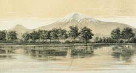
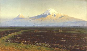
Ararat—located some 65 km (40 mi) south of the city–dominates the skyline of Armenia’s capital Yerevan.[26][95][115][116]
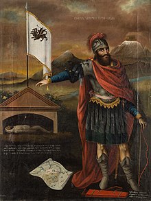
Hayk, the legendary founding father of the Armenian people, as depicted by Mkrtum Hovnatanian (1779–1846). Ararat is pictured in the background.
Despite lying outside the borders of modern Armenia, Ararat has historically been associated with Armenia,[120] and Armenians have being called by some authors the «people of Ararat».[121][122] It is widely considered the country’s principal national symbol and brand.[125] The image of Ararat, usually framed within a nationalizing discourse, is ubiquitous in everyday material culture in Armenia.[126] Tsypylma Darieva argues that Armenians have «a sense of possession of Ararat in the sense of symbolic cultural property.»[127]
There is historical and modern mountain worship around it among Armenians.[128][129][130] Ararat is known as the «holy mountain» of the Armenian people.[131][115][132] It was principal to the pre-Christian Armenian mythology, where it was the home of the gods.[133] With the rise of Christianity, the mythology associated with pagan worship of the mountain was lost.[134]
In the early 20th century, the Italian traveler Luigi Villari wrote, «Almost the whole history of the Armenian people centres round Mount Ararat.»[135] Ararat was the geographical center of ancient Armenian kingdoms.[e] One scholar defined the historic Greater Armenia (Armenia Major) as «the area about 200 miles [320 km] in every direction from Mount Ararat.»[139] In 19th-century era of romantic nationalism, when an Armenian state did not exist, Mount Ararat symbolized the historical Armenian nation-state.[140] In 1861 Armenian poet Mikael Nalbandian, witnessing the Italian unification, wrote to Harutiun Svadjian in a letter from Naples: «Etna and Vesuvius are still smoking; is there no fire left in the old volcano of Ararat?»[141]
Anglican priest and historian Theodore Edward Dowling wrote in 1910 that Mount Ararat and Etchmiadzin are the «two great objects of Armenian veneration.» He noted that the «noble snowy mountain takes the place, in the estimation of the Armenians, that Mount Sinai and the traditional Mount Zion do among the adherents of other Eastern Christians.»[142] While historian Jon Smele called Mt. Ararat and the medieval capital of Ani the «most cherished symbols of Armenian identity.»[143]
Myth of origin[edit]
The Genesis flood narrative was linked to the Armenian myth of origin by the early medieval historian Movses Khorenatsi. In his History of Armenia, he wrote that Noah and his family first settled in Armenia and later moved to Babylon. Hayk, a descendant of Japheth, a son of Noah, revolted against Bel (the biblical Nimrod) and returned to the area around Mount Ararat, where he established the roots of the Armenian nation. He is thus considered the legendary founding father and the name giver of the Armenian people.[144][145] According to Razmik Panossian, this legend «makes Armenia the cradle of all civilisation since Noah’s Ark landed on the ‘Armenian’ mountain of Ararat. […] it connects Armenians to the biblical narrative of human development. […] it makes Mount Ararat the national symbol of all Armenians, and the territory around it the Armenian homeland from time immemorial.»[146]
Coat of arms of Armenia[edit]
Mount Ararat has been depicted on the coat of arms of Armenia consistently since 1918. The First Republic’s coat of arms was designed by architect Alexander Tamanian and painter Hakob Kojoyan. This coat of arms was readopted by the legislature of the Republic of Armenia on April 19, 1992, after Armenia regained independence. Ararat is depicted along with the ark on its peak on the shield on an orange background.[147]
The emblem of the Armenian Soviet Socialist Republic (Soviet Armenia) was created by the painters Martiros Saryan and Hakob Kojoyan in 1921.[148] Mount Ararat is depicted in the center and makes up a large portion of it.[149]
-

-

-

Current Republic (1992–)


Ararat also appeared on the coat of arms of the Armenian Oblast and the Georgia-Imeretia Governorate (image), subdivisions of the Russian Empire that included the northern flanks of the mountain. They were adopted in 1833 and 1843, respectively.[150]
Symbol of genocide and territorial claims[edit]
In the aftermath of the Armenian genocide of 1915, Ararat came to represent the destruction of the native Armenian population of eastern Turkey (Western Armenia) in the national consciousness of Armenians.[f][152] Ari L. Goldman noted in 1988, «In most Armenian homes in the modern diaspora, there are pictures of Mount Ararat, a bittersweet reminder of the homeland and national aspirations.»[153]
Ararat has become a symbol of Armenian efforts to reclaim its «lost lands», i.e. the areas west of Ararat that are now part of Turkey that had significant Armenian population before the genocide.[16] Adriaans noted that Ararat is featured as a sanctified territory for the Armenians in everyday banal irredentism.[154] Stephanie Platz wrote, «Omnipresent, the vision of Ararat rising above Yerevan and its outskirts constantly reminds Armenians of their putative ethnogenesis … and of their exile from Eastern Anatolia after the Armenian genocide of 1915.»[155]

Lebanese Armenians protesting Turkish Prime Minister Erdoğan’s visit to Beirut in November 2010.[156] The poster reads «Ararat is and remains Armenian».[157]
Turkish political scientist Bayram Balci argues that regular references to the Armenian Genocide and Mount Ararat «clearly indicate» that the border with Turkey is contested in Armenia.[158] Since independence from the Soviet Union in 1991, the Armenian government has not made official claims to any Turkish territory,[158][159] however the Armenian government has avoided «an explicit and formal recognition of the existing Turkish-Armenian border.»[160] In a 2010 interview with Der Spiegel, Armenian President Serzh Sargsyan was asked whether Armenia wants «Mount Ararat back.» Sargsyan, in response, said that «No one can take Mount Ararat from us; we keep it in our hearts. Wherever Armenians live in the world today, you will find a picture of Mount Ararat in their homes. And I feel certain that a time will come when Mount Ararat is no longer a symbol of the separation between our peoples, but an emblem of understanding. But let me make this clear: Never has a representative of Armenia made territorial demands. Turkey alleges this—perhaps out of its own bad conscience?»[161]
The most prominent party to lay claims to eastern Turkey is the nationalist Armenian Revolutionary Federation (Dashnaktsutyun). which claims it as part of what it considers United Armenia.[162] In various settings, several notable individuals such as German historian Tessa Hofmann,[g] Slovak conservative politician František Mikloško,[h] Lithuanian political scientist and Soviet dissident Aleksandras Štromas[i] have spoken in support of Armenian claims over Mt. Ararat.
Cultural depictions[edit]

The first stamps issued by independent Armenia in 1992[166]

The mountain is notably featured on the Ararat brandy.
Levon Abrahamian noted that Ararat is visually present for Armenians in reality (it can be seen from many houses in Yerevan and settlements in the Ararat plain), symbolically (through many visual representations, such as on Armenia’s coats of arms), and culturally—in numerous and various nostalgic poetical, political, architectural representation.[167] The first three postage stamps issued by Armenia in 1992 after achieving independence from the Soviet Union depicted Mount Ararat.[166]
Mount Ararat has been depicted on various Armenian dram banknotes issued in 1993–2001; on the reverse of the 10 dram banknotes issued in 1993, on the reverse of the 50 dram banknotes issued in 1998, on the obverse of the 100 and 500 dram banknotes issued in 1993, and on the reverse of the 50,000 dram banknotes issued in 2001. It was also depicted on the reverse of the Turkish 100 lira banknotes of 1972–1986.[j]
Ararat is depicted on the logos of two of Armenia’s leading universities—the Yerevan State University and the American University of Armenia. It is depicted on the logos of Football Club Ararat Yerevan (since the Soviet times) and the Football Federation of Armenia. The logo of Armavia, Armenia’s now defunct flag carrier, also depicted Ararat. The publications of the Social Democrat Hunchakian Party in Lebanon (Ararad daily) and California, U.S. (Massis weekly) are both named for the mountain. The Ararat brandy, produced by the Yerevan Brandy Company since 1887, is considered the most prestigious Eastern European brandy.[168] Hotels in Yerevan often advertise the visibility of Ararat from their rooms, which is seen as a major advantage for tourists.[169][170][171]
In visual art[edit]
- European
Ararat was depicted in the books of European, including many British, travelers in the 18th–19th centuries who visited Armenia.


- Armenian
According to one source, the first Armenian artist to depict the mountain was Ivan Aivazovsky,[172] who created a painting of Ararat during his visit to Armenia in 1868.[173] Other major Armenians artists who painted Ararat include Yeghishe Tadevosyan, Gevorg Bashinjaghian, Martiros Saryan,[174] and Panos Terlemezian.

In literature[edit]
Rouben Paul Adalian suggested that «there is probably more poetry written about Mount Ararat than any other mountain on earth.»[134] Travel writer Rick Antonson described Ararat as the «most fabled mountain in the world.»[175]
Armenian[edit]


Mount Ararat is featured prominently in Armenian literature. According to Meliné Karakashian, Armenian poets «attribute to it symbolic meanings of unity, freedom, and independence.»[176] According to Kevork Bardakjian, in Armenian literature, Ararat «epitomizes Armenia and Armenian suffering and aspirations, especially the consequences of the 1915 genocide: almost total annihilation, loss of a unique culture and land […] and an implicit determination never to recognize the new political borders.»[177]
The last two lines of Yeghishe Charents’s 1920 poem «I Love My Armenia» (Ես իմ անուշ Հայաստանի) read: «And in the entire world you will not find a mountaintop like Ararat’s. / Like an unreachable peak of glory I love my Mount Masis.»[178] In a 1926[179] poem dedicated to the mountain Avetik Isahakyan wrote: «Ages as though in second came, / Touched the grey crest of Ararat, / And passed by…! […] It’s now your turn; you too, now, / Stare at its high and lordly brow, / And pass by…!»[180] Mount Ararat is the most frequently cited symbol in the poetry of Hovhannes Shiraz.[177] In collection of poems, Knar Hayastani (Lyre of Armenia) published in 1958, there are many poems «with very strong nationalist overtones, especially with respect to Mount Ararat (in Turkey) and the irredentism it entailed.» In one such poem, «Ktak» (Bequest), Shiraz bequeaths his son Mt. Ararat to «keep it forever, / As the language of us Armenians, as the pillar of your father’s home.»[181]
The first lines of Paruyr Sevak’s 1961 poem «We Are Few…» (Քիչ ենք, բայց հայ ենք) read: «We are few, but they say of us we are Armenians. / We do not think ourselves superior to anyone. / Clearly we shall have to accept / That we, and only we, have an Ararat»[182] In one short poem Silva Kaputikyan compares Armenia to an «ancient rock-carved fortress», the towers of which are Ararat and Aragats.
Non-Armenian[edit]
English Romantic poet William Wordsworth imagines seeing the ark in the poem «Sky-prospect — From the Plain of France.»[183][184]
In his Journey to Arzrum (Путешествие в Арзрум; 1835–36), the celebrated Russian poet Aleksandr Pushkin recounted his travels to the Caucasus and Armenia at the time of the 1828–29 Russo-Turkish War.
I went out of the tent into the fresh morning air. The sun was rising. Against the clear sky one could see a white-snowcapped, twin-peaked mountain. ‘What mountain is that?’ I asked, stretching myself, and heard the answer: ‘That’s Ararat.’ What a powerful effect a few syllables can have! Avidly I looked at the Biblical mountain, saw the ark moored to its peak with the hope of regeneration and life, saw both the raven and dove, flying forth, the symbols of punishment and reconciliation…[185]
Russian Symbolist poet Valery Bryusov often referred to Ararat in his poetry and dedicated two poems to the mountain,[k] which were published in 1917. Bryusov saw Ararat as the embodiment of antiquity of the Armenian people and their culture.[186]
Russian poet Osip Mandelstam wrote fondly of Ararat during his 1933 travels in Armenia. «I have cultivated in myself a sixth sense, an ‘Ararat’ sense,» the poet wrote, «the sense of an attraction to a mountain.»[187]
During his travels to Armenia, Soviet Russian writer Vasily Grossman observed Mount Ararat from Yerevan standing «high in the blue sky.» He wrote that «with its gentle, tender contours, it seems to grow not out of the earth but out of the sky, as if it has condensed from its white clouds and its deep blue. It is this snowy mountain, this bluish-white sunlit mountain that shone in the eyes of those who wrote the Bible.»[188]
In The Maximus Poems (1953) American poet Charles Olson, who grew up near the Armenian neighborhood in Worcester, Massachusetts, compares the Ararat Hill near his childhood home to the mountain and «imagines he can capture an Armenian’s immigrant perspective: the view of Ararat Hill as Mount Ararat.»[189]
The world renowned Turkish-Kurdish writer Yaşar Kemal’s 1970 book entitled Ağrı Dağı Efsanesi (The Legend of Mount Ararat) is about a local myth about a poor boy and the governor’s daughter.
Several major episodes in Declare (2001) by Tim Powers take place on Mount Ararat. In the book, it is the focal point of supernatural happenings.
In popular culture[edit]

In music[edit]
- «Holy Mountains», the 8th track of the album Hypnotize (2005) by System of a Down, an American rock band composed of four Armenian Americans, «references Mount Ararat […] and details that the souls lost to the Armenian Genocide have returned to rest here.»[191]
- «Here’s to You Ararat» is a song from the 2006 album How Much is Yours of Arto Tunçboyacıyan’s Armenian Navy Band.[192]
- «Sunrise on Ararat» is a song from the 1996 album First Call of First Call an American Contemporary Christian music group. The songs features the 10 time Grammy winner group Take 6 .
In film[edit]
- The 2002 film Ararat by Armenian-Canadian filmmaker Atom Egoyan features Mount Ararat prominently in its symbolism.[193]
- The 2011 documentary film Journey to Ararat on Parrot and Abovian’s expedition to Ararat was produced in Estonia by filmmaker Riho Västrik.[194][195] It was screened at the Golden Apricot International Film Festival in Yerevan in 2013.[196]
Places named for Ararat[edit]
- In Armenia
- In Armenia, four settlements are named after the mountain’s two names: Ararat and Masis. All are located in the Ararat Plain. First, the village of Davalu was renamed Ararat in 1935, followed by Tokhanshalu being renamed Masis in 1945, and the workers town of Davalu’s nearby cement factory also being renamed Ararat in 1947. The latter became a city in 1962. The railway town of Ulukhanlu was renamed Masis in 1950, while the former village/town of Ulukhanlu, renamed Hrazdan and then Masis in 1969. The two merged to form the urban-type settlement of Masis, the current town, in 1971.[197][198]
- There were previously administrative divisions (shrjan or raion) called Ararat and Masis (called Vedi until 1968), formed in 1930 and 1968, respectively. They became a part of the province (marz) of Ararat in the 1995.[199]
- The name is also used in two dioceses of the Armenian Apostolic Church: the Araratian Pontifical Diocese and the Diocese of Masyatsotn, encompassing capital Yerevan and the Ararat province, respectively.[200][201]
- Elsewhere
- The Turkish province of Ağrı was named after the Turkish name of the mountain in 1927, while the provincial capital city of Karaköse was renamed to Ağrı in 1946.[202]
- In the United States, a river in Virginia and North Carolina was named Ararat after the mountain no later than 1770. An unincorporated community in North Carolina was later named after the river.[203] A township and a mountain in Pennsylvania are called Ararat.[204]
- In the Australian state of Victoria, a city was named Ararat in 1840. Its local government area is also called Ararat.[205][206]
- 96205 Ararat is an asteroid named in the mountain’s honor. It was discovered in 1992 by Freimut Börngen and Lutz D. Schmadel at Tautenburg Observatory in Germany. The name was proposed by Börngen.[207]
States[edit]
- Besides Ararat being the Hebrew version of Urartu,[13] this Iron Age state is often referred to as the «Araratian Kingdom» or the «Kingdom of Ararat» (Armenian: Արարատյան թագավորություն, Arartyan t’agavorut’yun) in Armenian historiography.[208] Levon Abrahamian argues that this name gives it a «biblical and an Armenian touch.»[209]
- The First Republic of Armenia, the first modern Armenian state that existed between 1918 and 1920, was sometimes called the Araratian Republic or the Republic of Ararat (Armenian: Արարատյան Հանրապետություն, Araratyan hanrapetut’yun)[210][211] as it was centered in the Ararat plain.[212][213]
- In 1927 the Kurdish nationalist party Xoybûn led by Ihsan Nuri, fighting an uprising against the Turkish government, declared the independence of the Republic of Ararat (Kurdish: Komara Agiriyê), centered around Mount Ararat.[214][215]
Gallery[edit]
-

-
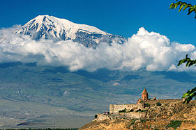
View of Ararat with the Khor Virap in the front, Armenia
-

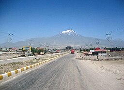
View of Ararat from Iğdır, Turkey
-

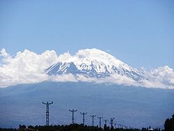
From Doğubeyazıt
-
From Iğdır
-
From Nakhchivan


See also[edit]
- Mount Alvand
- Kurdish melodies
- Mount Judi
Notes[edit]
- ^ ARR-ə-rat; Turkish: Ağrı Dağı; Armenian: Մասիս, romanized: Masis or Արարատ, Ararat; Kurdish: Çiyayê Agirî [tʃɪjɑːjeː ɑːɡɪɾiː] (
 listen) or Kurdish: Grîdax [ɡɾiːdɑːx] (listen)
- ^ The peaks are sometimes referred to in plural as Մասիսներ Masisner.[25] Greater Ararat is known as simply Masis or Մեծ Մասիս (Mets Masis, «Great/Big Masis»). While Lesser Ararat is known as Sis (Սիս)[26][27] or Փոքր Մասիս (P′ok′r Masis, «Little/Small Masis»).[18][25] The word «Ararat» occurs in Armenian literature from the early medieval period, following the invention of the Armenian alphabet.[28]
- ^ Strabo, Geographica, XI.14.2 and XI.14.14.[43] They are also transliterated as Abus and Nibarus.[44] Abos and Nibaros are the two peaks of Ararat according to scholars such as Nicholas Adontz,[43] Vladimir Minorsky,[45] Julius Fürst.[46]
- ^
- Richard James Fischer: «The Genesis text, using the plural ‘mountains’ (or hills), identifies no particular mountain, but points generally toward Armenia (‘Ararat’ being identical with the Assyrian ‘Urartu’) which is broadly embraces [sic] that region.»[89]
- Exell, Joseph S.; Spence-Jones, Henry Donald Maurice (eds.). «Genesis». The Pulpit Commentary.
It is agreed by all[clarification needed] that the term Ararat describes a region.
view online - Dummelow, John, ed. (1909). «Genesis». John Dummelow’s Commentary on the Bible.
Ararat is the Assyrian ‘Urardhu,’ the country round Lake Van, in what is now called Armenia… and perhaps it is a general expression for the hilly country which lay to the N. of Assyria. Mt. Masis, now called Mt. Ararat (a peak 17,000 ft. high), is not meant here.
view online - Bill T. Arnold: «Since the ancient kingdom of Ararat/Urartu was much more extensive geographically than this isolated location in Armenia, modern attempts to find remaints of Noah’s ark here are misguided.»[90]
- Vahan Kurkjian: «It has long been the notion among many Christians that Noah’s Ark came to rest as the Flood subsided upon the great peak known as Mount Ararat; this assumption is based upon an erroneous reading of the 4th verse of the VIIIth chapter of Genesis. That verse does not say that the Ark landed upon Mount Ararat, but upon ‘the mountains of Ararat.’ Now, Ararat was the Hebrew version of the name, not of the mountain but of the country around it, the old Armenian homeland, whose name at other times and in other tongues appears variously as Erirath, Urartu, etc.»[91]
- ^ «…Mt. Ararat, which was the geographical center of the ancient Armenian kingdoms…»[136]
- «The sacred mountain stands in the center of historical and traditional Armenia…»[137]
- «To the Armenians it is the ancient sanctuary of their faith, the centre of their once famous kingdom, hallowed by a thousand traditions.»[138]
- ^ «The lands of Western Armenia which Mt. Ararat represent…»[140] «mount Ararat is the symbol of banal irredentism for the territories of Western Armenia»[151]
- ^ Hofmann suggested that «the return of the ruins of Ani and of Mount Ararat [by Turkey to Armenia], both in the immediate border area could be considered as a convincing gesture of Turkey’s apologies and will for reconciliation.»[163]
- ^ Mikloško stated at a 2010 conference on Turkey’s foreign policy: «Mount Ararat [represents the] Christian heritage of Armenians. Does modern Turkey consider the possibility of giving the mount back to Armenians? The return of Ararat would be an unprecedented step to signify Turkey’s willingness to build a peaceful future and promote its image at the international scene.»[164]
- ^ Štromas wrote: «The Armenians would also be right to claim from Turkey the Ararat Valley, which is an indivisible part of the Armenian homeland containing the main spiritual center and supreme symbol of Armenia’s nationhood, the holy Mountain of Ararat itself.»[165]
- ^ Central Bank of the Republic of Turkey. Banknote Museum: 6. Emission Group – One Hundred Turkish Lira – I. Series, II. Series & III. Series.
- ^ «К Арарату» («To Ararat») and «Арарат из Эривани» («Ararat from Erivan»)
References[edit]
Citations[edit]
- ^ «100 World Mountains ranked by primary factor». ii.uib.no. Institutt for informatikk University of Bergen. Archived from the original on 2016-05-21. Retrieved 2016-05-09.
- ^ «Ağrı Dağı Milli Parkı [Ağrı Dağı National Park]». ormansu.gov.tr (in Turkish). Republic of Turkey Ministry of Forest and Water Management. Archived from the original on 2016-05-05. Retrieved 2016-04-11.
- ^ a b c d e f g h i Yilmaz, Y.; Güner, Y.; Saroğlu, F. (1998). «Geology of the quaternary volcanic centres of the east Anatolia». Journal of Volcanology and Geothermal Research. 85 (1–4): 173–210. Bibcode:1998JVGR…85..173Y. doi:10.1016/s0377-0273(98)00055-9.
- ^ Short, Nicholas M.; Blair, Robert W., eds. (1986). «Mt. Ararat, Turkey». Geomorphology From Space: A Global Overview of Regional Landforms. National Aeronautics and Space Administration. p. 226.
- ^ a b de Planhol, X. (1986). «Ararat». Encyclopædia Iranica. Archived from the original on 2015-11-02. Retrieved 2015-11-03.
- ^ Hovannisian, Richard G. (1973). «Armenia and the Caucasus in the Genesis of the Soviet-Turkish Entente». International Journal of Middle East Studies. 4 (2): 129–147. doi:10.1017/s0020743800027409. JSTOR 162238. S2CID 162360397.
…Nationalist Turkey annexed the Surmalu district, embracing Mount Ararat, the historic symbol of the Armenian people.
- ^ de Waal, Thomas (2015). Great Catastrophe: Armenians and Turks in the Shadow of Genocide. Oxford University Press. p. 86. ISBN 978-0199350698.
- ^ a b Parrot 2016, p. xxiii.
- ^ Yildiz, Kerim; Taysi, Tanyel B. (2007). The Kurds in Iran: The Past, Present and Future. London: Pluto Press. p. 71. ISBN 978-0745326696.
- ^ Tsutsiev, Arthur (2014). Atlas of the Ethno-Political History of the Caucasus. Translated by Nora Seligman Favorov. New Haven: Yale University Press. p. 92. ISBN 978-0300153088.
- ^ Westerman, Frank (2008-12-02). Ararat: In Search of the Mythical Mountain. Random House. ISBN 978-1-4070-1951-2.
- ^ Frymer, Tikva S.; Sperling, S. David (2008). «Ararat, Armenia». Encyclopaedia Judaica (2nd ed.). view online Archived 2015-12-22 at the Wayback Machine
- ^ a b c Arnold 2008, p. 104.
- ^ Rogers, Thorold (1884). Bible Folk-Lore: A Study in Comparative Methodology. London: Kegan Paul, Trench, Trübner & Co. p. 21.
Ararat was thought by Gesenius to be a Sanskrit word (Arjawartah), signifying «holy ground,»…
- ^ Bonomi, Joseph (1866). «Ararat». In Fairbairn, Patrick (ed.). The Imperial Bible-Dictionary: Historical, Biographical, Geographical and Doctrinal — Volume I. Glasgow: Blackie and Son. p. 118.
- ^ a b Avakyan, K. R. (2009). «Աշոտ Մելքոնյան, Արարատ. Հայոց անմահության խորհուրդը [Ashot Melkonyan, Ararat. Symbol of Armenian Immortality]». Lraber Hasarakakan Gitutyunneri (in Armenian). № 1 (1): 252–257. Archived from the original on 2015-11-18. Retrieved 2015-11-17.
Պատմական ճակատագրի բերումով Արարատ-Մասիսը ոչ միայն վեհության, անհասանելիության, կատարելության մարմնավորում է, այլև 1915 թ. հայոց մեծ եղեռնից ու հայ ժողովրդի հայրենազրկումից հետո՝ բռնազավթված հայրենիքի և այն նորեն իր արդար զավակներին վերադարձելու համոզումի անկրկնելի խորհրդանիշ, աշխարհասփյուռ հայության միասնականության փարոս» (էջ 8):
- ^ Teryan, Anzhela (31 August 2011). «Երևան անվան ծագման մասին [On the origin of the name Yerevan]» (in Armenian). Yerevan History Museum. Archived from the original on 7 June 2018.
Հայտնի է, որ Հայկական լեռնաշխարհում Ար-ով /նաև էր, Ուր, Իր/ սկսվող բազմաթիվ աշխարհագրական (նաև անձնական) անուններ կան. Արարատ, Արագած, Արա, Արաքս, Արածանի, Արմավիր, Արճեշ…: Այս երևույթը կապված է Արարչի /Ար Աստված/ և նրա պաշտանմունքն ունեցող Հայկական լեռնաշխարհի բնիկների՝ հայ-արմենների՝ արմեն, նաև արի /Էրի/ անվան հետ:
- ^ a b c d Hewsen, Robert H. (2001). «Armenia: The Physical Setting—Mt. Ararat». Armenia: A Historical Atlas. University of Chicago Press. p. 15. ISBN 978-0-226-33228-4.
- ^ Smith, Eli (1832). «Foreign Correspondence». The Biblical Repository and Classical Review: 203.
…called by the Armenians, Masis, and by Europeans generally Ararat…
- ^ a b Bryce 1877, p. 198.
- ^ Alexander Agadjanian (15 April 2016). Armenian Christianity Today: Identity Politics and Popular Practice. Routledge. p. 14. ISBN 978-1-317-17857-6.
It is worth noting that, contrary to Armenian Apostolic Church discourse and popular knowledge, it was probably as late as the beginning of the second millennium AD when the localization of the biblical Mount Ararat was permanently moved from the highlands hemming upper Mesopotamia to Mount Masis in the heart of historical Armenian territory.
- ^ Petrosyan, Hamlet (2001). «The Sacred Mountain». In Levon Abrahamian and Nancy Sweezy (ed.). Armenian Folk Arts, Culture, and Identity. Indiana University Press. p. 36. ISBN 978-0-253-33704-7.
When Armenians were first introduced to the biblical story of the flood, there was no special interest in the location of Mount Ararat. Most Armenian historians in the Early Middle Ages accepted the generally held Christian opinion of the time that Ararat was located near Mesopotamia in Korduk (Corduene), the southernmost province of Armenia. However, when European Crusaders on their way to free the Holy Land from Moslem rule appeared in the region in the 11th century, Armenian hopes for similar «salvation» helped to catalyze the final identification of Masis with Ararat. From the 12th century on, Catholic missionaries and other travelers to the region returned to Europe with the same story: that the mountain where the Ark landed was towering in the heart of Armenia.
- ^ a b Jastrow, Morris Jr.; Kent, Charles Foster (1902). «Ararat». Jewish Encyclopedia Volume II. New York, NY: Funk & Wagnalls Co. p. 73.
The mountain itself is known as Ararat only among Occidental geographers. The Armenians call it Massis, the Turks Aghri Dagh, and the Persians Koh i Nuh, or «the mountain of Noah.»
view online Archived 2015-11-25 at the Wayback Machine - ^ Avetisyan, Kamsar (1979). Հայրենագիտական էտյուդներ [Armenian studies sketches] (in Armenian). Yerevan: Sovetakan grogh. p. 14. Archived from the original on 2015-11-27. Retrieved 2015-11-24.
Հայերը Արարատը անվանում են Մասիս…
- ^ a b «Մասիսներ» [Masisner]. encyclopedia.am (in Armenian). Archived from the original on 2016-08-16. Retrieved 2016-06-13.
- ^ a b Peroomian, Rubina (2007). «Historical Memory: Threading the Contemporary Literature of Armenia». In Hovannisian, Richard (ed.). The Armenian Genocide: Cultural and Ethical Legacies. Transaction Publishers. p. 113. ISBN 9781412835923.
…the majestic duo of Sis and Masis (the two peaks of Mount Ararat) that hover above the Erevan landscape are constant reminders of the historical injustice.
- ^ Delitzsch, Franz (2001). New Commentary on Genesis. Wipf and Stock Publishers. p. 274. ISBN 978-1-57910-813-7.
The Armenians call Little Ararat sis and Great Ararat masis, whence it seems that great, the meaning of meds, is contained in ma.
- ^ Hovhannisyan, L. Sh. (2016). Բառերի մեկնությունը հինգերորդ դարի հայ մատենագրուտյան մեջ [Interpretation of words in 5th century Armenian manuscripts] (in Armenian). Yerevan: Gitutyun. p. 61.
- ^ Khorenatsi 1978, p. 91.
- ^ a b Petrossyan 2010, p. 221.
- ^ a b c Novoseltsev 1978.
- ^ Petrosyan 2016, p. 72.
- ^ Armen Petrosyan. «Biblical Mt. Ararat: Two Identifications.» Comparative Mythology. December 2016. Vol. 2. Issue 1. pp. 68-80.
- ^ As of 2022, there were 5489 and 882 people named Ararat and Masis, respectively, in Armenia’s voters’ list
- «Արարատ (Ararat)». anun.am (in Armenian). Archived from the original on 5 January 2023.
- «Մասիս (Masis)». anun.am. Archived from the original on 10 August 2022.
- ^ «Ararat». Encyclopædia Britannica. Retrieved 2019-11-18.
ˈer-ə-ˌrat, ˈa-rə-
- ^ Dalton, Robert H. (2004). Sacred Places of the World: A Religious Journey Across the Globe. Abhishek. p. 133. ISBN 9788182470514.
The Turkish name for Mt Ararat is Agri Dagi (which means mountain of pain).
- ^ McCarta, Robertson (1992). Turkey (2nd ed.). Nelles. p. 210. ISBN 9783886184019.
(Turkish: Agri Dagi, «Mount of Sorrows»)
- ^ a b Nişanyan, Sevan. «Ağrı». NişanyanYerAdları. Retrieved 26 July 2022.
- ^ a b Sarıkaya, Mehmet Akif (2012). «Recession of the ice cap on Mount Ağrı (Ararat), Turkey, from 1976 to 2011 and its climatic significance». Journal of Asian Earth Sciences. 46: 190–194. Bibcode:2012JAESc..46..190S. doi:10.1016/j.jseaes.2011.12.009.
- ^ «Xortekî tirk dixwaze bi bîsîklêtê xwe ji çiyayê Agirî berde xwarê» (in Kurdish). Rudaw Media Network. 19 June 2014. Archived from the original on 17 November 2015. Retrieved 16 November 2015.
- ^ Waugh, Alexander (27 August 2008). «Will he, won’t He? Ararat by Frank Westerman, translated by Sam Garrett». The Spectator. Archived from the original on 11 August 2016. Retrieved 22 June 2016.
- ^ Akkuş, Murat. «Ağrı Dağı’nın adı «Ararat» olmalı». basnews. Retrieved 26 July 2022.
- ^ a b Petrossyan 2010, p. 220.
- ^ Jones, Horace Leonard, ed. (1928). «XI.14». The Geography of Strabo. Harvard University Press. view Book XI, Chapter 14 online
- ^ Minorsky, V. (1944). «Roman and Byzantine Campaigns in Atropatene». Bulletin of the School of Oriental and African Studies, University of London. 11 (2): 243–265. doi:10.1017/S0041977X0007244X. JSTOR 609312. S2CID 129323675.
Although what Strabo means by Abos seems to be the southern spurs of Mt. Ararat…
- ^ Julius Fürst cited in Exell, Joseph; Jones, William; Barlow, George; Scott, W. Frank; et al. (1892). The Preacher’s Complete Homiletical Commentary. «…the present Aghri Dagh or the great Ararat (Pers. Kuhi Nuch, i.e. Noah’s mountain, in the classics ὁ ἄβος, Armen. massis)…» (Furst.) view online Archived 2016-08-12 at the Wayback Machine
- ^ «Ağrı – Mount Ararat». Republic of Turkey Ministry of culture and tourism (kultur.gov.tr). 2005.
- ^ «Mount Agri (Ararat)». anatolia.com. 2003. Retrieved 26 December 2020.
the Serdarbulak lava plateau (2600 m) stretches out between the two pinnacles.
- ^ Merriam-Webster’s Geographical Dictionary (3rd ed.). Springfield, Massachusetts: Merriam-Webster. 2001. p. 63. ISBN 9780877795469.
- ^ Haggett, Peter, ed. (2002). «Turkey». Encyclopedia of World Geography: The Middle East (2nd ed.). Marshall Cavendish. p. 2026. ISBN 978-0-7614-7289-6.
- ^ Hartemann, Frederic; Hauptman, Robert (2005). The Mountain Encyclopedia. Lanham, Maryland: Taylor Trade. p. 17. ISBN 978-0-8108-5056-9.
- ^ Galichian, Rouben (2004). Historic Maps of Armenia: The Cartographic Heritage. I.B. Tauris. p. 26. ISBN 978-1-86064-979-0.
- ^ Kurter, Ajun (20 May 1988). «Glaciers of the Middle East and Africa: Turkey» (PDF). United States Geological Survey Professional Paper 1386-G. Archived (PDF) from the original on 11 October 2017.
- ^ «Maps of Ararat — Ararat Map, Turkey (Agri Dagi)». turkeyodyssey.com. Terra Anatolia. Archived from the original on 2007-02-25.
- ^ According to Petter E. Bjørstad, Head of Informatics Department at the University of Bergen (Norway). «Ararat Trip Report». ii.uib.no. August 2007. Archived from the original on 11 October 2017.
I measured the summit elevation, averaging more than 300 samples in my GPS, it settled on 5132 meter, 5 meter lower than the often quoted 5137 figure. This clearly shows that the 5165 meter elevation that many sources use is wrong. The summit is a snow ridge with no visible rock anywhere. Thus, the precise elevation will change with the seasons and could definitely be influenced by climate change (global warming). Later GPS measurements in Iran suggested that the GPS data may be about 10 meter too high also in this part of the world. This would in fact point in the direction of a true Ararat elevation around 5125 meter.
- ^ a b c Blumenthal, M. M. (1958). «Vom Agrl Dag (Ararat) zum Kagkar Dag. Bergfahrten in nordostanatolischen Grenzlande». Die Alpen (in German). 34: 125–137.
- ^ a b Sarıkaya, Mehmet Akif; Tekeli, A. E. (2014). «Satellite inventory of glaciers in Turkey». In J. S. Kargel; et al. (eds.). Global Land Ice Measurements from Space. New York: Springer-Verlag. pp. 465–480. ISBN 978-3540798170.
- ^ Yalcin, Mustafa (2020). «A GIS-Based Multi-Criteria Decision Analysis Model for Determining Glacier Vulnerability». ISPRS International Journal of Geo-Information. 9 (3): 180. Bibcode:2020IJGI….9..180Y. doi:10.3390/ijgi9030180.
- ^ a b Birman, J. H. (1968). «Glacial Reconnaissance in Turkey». Geological Society of America Bulletin. 79 (8): 1009–1026. Bibcode:1968GSAB…79.1009B. doi:10.1130/0016-7606(1968)79[1009:GRIT]2.0.CO;2.
- ^ a b Dewey, J. F.; Hempton, M. R.; Kidd, W. S. F.; Saroglum, F.; Sengὃr, A. M. C. (1986). «Shortening of continental lithosphere: the neotectonics of Eastern Anatolia – a young collision zone». In Coward, M. P.; Ries, A. C. (eds.). Collision Tectonics. Geological Society of London. pp. 3–36.
- ^ a b c d Karakhanian, A.; Djrbashian, R.; Trifonov, V.; Philip, H.; Arakelian, S.; Avagian, A. (2002). «Holocene–Historical Volcanism and Active Faults as Natural Risk Factor for Armenia and Adjacent Countries». Journal of Volcanology and Geothermal Research. 113 (1): 319–344. Bibcode:2002JVGR..113..319K. doi:10.1016/s0377-0273(01)00264-5.
- ^ a b c d Karakhanian, A.S.; Trifonov, V.G.; Philip, H.; Avagyan, A.; Hessami, K.; Jamali, F.; Bayraktutan, M. S.; Bagdassarian, H.; Arakelian, S.; Davtian, V.; Adilkhanyan, A. (2004). «Active faulting and natural hazards in Armenia, Eastern Turkey and North-Western Iran». Tectonophysics. 380 (3–4): 189–219. Bibcode:2004Tectp.380..189K. doi:10.1016/j.tecto.2003.09.020.
- ^ Allen, Mark B.; Mark, Darren F.; Kheirkhah, Monireh; Barfod, Dan; Emami, Mohammad H.; Saville, Christopher (2011). «40Ar/39Ar dating of Quaternary lavas in northwest Iran: constraints on the landscape evolution and incision rates of the Turkish–Iranian plateau» (PDF). Geophysical Journal International. 185 (3): 1175–1188. Bibcode:2011GeoJI.185.1175A. doi:10.1111/j.1365-246x.2011.05022.x.
- ^ a b Siebert, L., T. Simkin, and P. Kimberly (2010) Volcanoes of the world, 3rd ed. University of California Press, Berkeley, California. 551 pp. ISBN 978-0-520-26877-7.
- ^ a b Haroutiunian, R. A. (2005). «Катастрофическое извержение вулкана Арарат 2 июля 1840 года» [Catastrophic eruption of volcano Ararat on 2 july, 1840]]. Proceedings of the National Academy of Sciences of the Republic of Armenia: Earth Sciences (in Russian). 58 (1): 27–35. ISSN 0515-961X. Archived from the original on 2015-12-07. Retrieved 2015-11-26.
- ^ Taymaz, Tuncay; Eyidog̃an, Haluk; Jackson, James (1991). «Source parameters of large earthquakes in the East Anatolian fault zone (Turkey)». Geophysical Journal International. 106 (3): 537–550. Bibcode:1991GeoJI.106..537T. doi:10.1111/j.1365-246x.1991.tb06328.x.
- ^ a b William of Rubruck (1998). The Journey of William of Rubruck to the Eastern Parts of the World, 1253–55. Translated by W. W. Rockhill. New Delhi: Asian Educational Services. p. 269–270. ISBN 978-81-206-1338-6.
[…] mountains in which they say that Noah’s ark rests; and there are two mountains, the one greater than the other; and the Araxes flows at their base […] Many have tried to climb it, but none has been able. […] An old man gave me quite a good reason why one ought not to try to climb it. They call the mountain Massis […] «No one,» he said, «ought to climb up Massis; it is the mother of the world.»
- ^ Stackhouse, Thomas (1836). A History of the Holy Bible. Glasgow: Blackie and Son. p. 93.
- ^ Siekierski, Konrad (2014). ««One Nation, One Faith, One Church»: The Armenian Apostolic Church and the Ethno-Religion in Post-Soviet Armenia». In Agadjanian, Alexander (ed.). Armenian Christianity Today: Identity Politics and Popular Practice. Ashgate Publishing. p. 14. ISBN 978-1-4724-1273-7.
- ^ Parrot 2016, p. 139
- ^ a b Randveer, Lauri (October 2009). «How the Future Rector Conquered Ararat». University of Tartu. Archived from the original on 2015-11-25. Retrieved 2015-11-25.
- ^ Khachaturian, Lisa (2011). Cultivating Nationhood in Imperial Russia: The Periodical Press and the Formation of a Modern Armenian Identity. Transaction Publishers. p. 52. ISBN 978-1-4128-1372-3.
- ^ Milner, Thomas (1872). The Gallery of Geography: A Pictorial and Descriptive Tour of the World, Volume 2. W.R. M’Phun & Son. p. 783.
Great Ararat was ascended for the first time by Professor Parrot, October 9, 1829…
- ^ Giles, Thomas (27 April 2016). «Friedrich Parrot: The man who became the ‘father of Russian mountaineering’«. Russia Beyond the Headlines. Archived from the original on 24 June 2018. Retrieved 19 April 2017.
- ^ Ketchian, Philip K. (December 24, 2005). «Climbing Ararat: Then and Now». The Armenian Weekly. 71 (52). Archived from the original on September 8, 2009.
- ^ Parrot 2016, p. 142.
- ^ Parrot 2016, p. 141-142.
- ^ Parrot 2016, p. 183.
- ^ Fairbairn, Patrick (1866). «Ararat». The Imperial Bible-Dictionary: Historical, Biographical, Geographical and Doctrinal – Volume I. p. 119.
- ^ Polo, Marco; Yule, Henry (2010). The Book of Ser Marco Polo, the Venetian: Concerning the Kingdoms and Marvels of the East, Volume 1. Cambridge University Press. p. 49. ISBN 978-1-108-02206-4.
- ^ B. J. Corbin and Rex Geissler, The Explorers of Ararat: And the Search for Noah’s Ark, 3rd. edition (2010), chap. 3.
- ^ a b Bryce, James (1878). «On Armenia and Mount Ararat». Proceedings of the Royal Geographical Society of London. 22 (3): 169–186. doi:10.2307/1799899. JSTOR 1799899.
- ^ Lynch, H. F. B. (1893). «The ascent of Ararat». The Geographical Journal. 2: 458.
- ^ Lynch, H. F. B. (1901). Armenia, travels and studies. Volume I: The Russian Provinces. London: Longmans, Green, and Co. p. 176.
- ^ «Conquering the legendary Mount Ararat». Hürriyet Daily News. 15 January 2006. Archived from the original on 22 February 2014.
- ^ Spar, Ira (2003). «The Mesopotamian Legacy: Origins of the Genesis tradition». In Aruz, Joan (ed.). Art of the First Cities: The Third Millennium B.C. from the Mediterranean to the Indus. New York: Metropolitan Museum of Art. p. 488. ISBN 978-1-58839-043-1. Archived from the original on 2015-11-29. Retrieved 2015-11-08.
- ^ «The Manner how the Whole Earth was Peopled by Noah & his Descendants after the Flood». British Museum. Archived from the original on December 27, 2020.
- ^ Morgenstern, Julian (1941). «Psalm 48». Hebrew Union College Annual. 16: 1–95. JSTOR 23502992.
Note the plural, hare ‘Ararat; not «Mt. Ararat,» as traditionally translated and interpreted, but rather «(one of) the mountains of Ararat,» i. e. of Urartu or Armenia.
- ^ a b Fischer, Richard James (2007). «Mount Ararat». Historical Genesis: From Adam to Abraham. University Press of America. pp. 109–111. ISBN 9780761838074. Archived from the original on 2019-01-28. Retrieved 2016-11-03.
- ^ a b Arnold 2008, p. 105.
- ^ Kurkjian, Vahan (1964) [1958]. A History of Armenia. New York: Armenian General Benevolent Union of America. p. 2.
- ^ Room, Adrian (1997). Placenames of the World: Origins and Meanings. McFarland. p. 34. ISBN 9780786401727.
- ^ a b c Vos, Howard F. (1982). «Flood (Genesis)». In Bromiley, Geoffrey W. (ed.). International Standard Bible Encyclopedia: E-J (fully revised ed.). Wm. B. Eerdmans Publishing. p. 319. ISBN 978-0-8028-3782-0.
- ^ Tremblais, Jean-Louis (16 July 2011). «Ararat, montagne biblique». Le Figaro (in French). Archived from the original on 17 November 2015. Retrieved 9 November 2015.
- «Biblical mountain’s glaciers shrinking». News24. 8 August 2010. Archived from the original on 17 November 2015. Retrieved 16 November 2015.
- ^ a b Avagyan, Ṛafayel (1998). Yerevan—heart of Armenia: meetings on the roads of time. Union of Writers of Armenia. p. 17.
The sacred biblical mountain prevailing over Yerevan was the very visiting card by which foreigners came to know our country.
- ^ Bailey, Lloyd R. (1990). «Ararat». In Mills, Watson E.; Bullard, Roger Aubrey (eds.). Mercer Dictionary of the Bible. Mercer University Press. p. 54. ISBN 978-0-86554-373-7. Archived from the original on 2019-01-28. Retrieved 2016-11-03.
…the local (Armenian) population called Masis and which they began to identify as the ark’s landing place in the eleventh-twelfth centuries.
- ^ Conybeare, F. C. (1901). «Reviewed Work: Ararat und Masis. Studien zur armenischen Altertumskunde und Litteratur by Friedrich Murad». The American Journal of Theology. 5 (2): 335–337. doi:10.1086/477703. JSTOR 3152410.
- ^ a b Spencer, Lee; Lienard, Jean Luc (2005). «The Search for Noah’s Ark». Southwestern Adventist University. Archived from the original on 2015-03-14. Retrieved 2015-11-03. (archived)
- ^ Mandeville, John (2012). The Book of Marvels and Travels. Translated by Anthony Bale. Oxford University Press. p. 70. ISBN 9780199600601.
- ^ Mandel, Jerome (2013). «Ararat, Mount». In Friedman, John Block; Figg, Kristen Mossler (eds.). Trade, Travel, and Exploration in the Middle Ages: An Encyclopedia. Routledge. p. 30. ISBN 978-1-135-59094-9.
- ^ «Նոյն իջնում է Արարատից (1889) [Descent of Noah from Ararat (1889)]» (in Armenian). National Gallery of Armenia. Archived from the original on 2015-09-24. Retrieved 2015-11-03.
- ^ Conway Morris, Roderick (24 February 2012). «The Key to Armenia’s Survival». The New York Times. Archived from the original on 7 March 2017. Retrieved 11 February 2017.
- ^ a b original title: Dictionnaire historique, critique, chronologique, geographique et literal de la Bible. English translation: Calmet, Augustin (1830). «Ararat». Calmet’s Dictionary of the Holy Bible: With the Biblical Fragments, Volume 1. Charles Taylor (translator). London: Holdsworth and Ball. p. 178–179.
- ^ Jamieson, Robert; Fausset, Andrew Robert; Brown, David (1871). Commentary Critical and Explanatory on the Whole Bible. view Genesis 8:4 commentary online Archived 2016-08-20 at the Wayback Machine
- ^ Dwight 1856, p. 189:
- ^ «Homily of John Paul II». vatican.va. Holy See. 26 September 2001. Archived from the original on 19 December 2016.
{{cite web}}: CS1 maint: bot: original URL status unknown (link) - ^ «Приветственная речь Святейшего Патриарха Кирилла в кафедральном соборе Эчмиадзина [Welcome speech by His Holiness Patriarch Kirill at the Cathedral of Etchmiadzin]». patriarchia.ru (in Russian). Russian Orthodox Church. 16 March 2010. Archived from the original on 19 December 2016.
Каждый, кто приезжает в Армению, получает неизгладимое впечатление, лицезрея ее главный символ — священную гору Арарат, на которой остановился после потопа ковчег праотца Ноя.
{{cite web}}: CS1 maint: bot: original URL status unknown (link) - ^ Patai, Raphael; Oettinger, Ayelet (2015). «Ararat». In Patai, Raphael; Bar-Itzhak, Haya (eds.). Encyclopedia of Jewish Folklore and Traditions. Routledge. pp. 50–51. ISBN 9780765620255.
- ^ Balsiger, David; Sellier, Charles E. Jr. (1974). In Search of Noah’s Ark. Sunn Classic Books. p. 203.
- ^ Zenian, David (1 July 1996). «The Holy Etchmiadzin Museum: History of a Long Journey». AGBU Magazine. Archived from the original on 22 October 2017. Retrieved 11 October 2017.
- ^ Mayell, Hillary (27 April 2004). «Noah’s Ark Found? Turkey Expedition Planned for Summer». National Geographic. pp. 1, 2. Archived from the original on 14 April 2010. Retrieved 26 November 2015.
- ^ Cline, Eric H. (2009). Biblical Archaeology: A Very Short Introduction. Oxford University Press. p. 72. ISBN 978-0-19-534263-5.
- ^ Fagan, Garrett G. (2006). Archaeological Fantasies: How Pseudoarchaeology Misrepresents the Past and Misleads the Public. Psychology Press. p. 69. ISBN 978-0-415-30592-1.
- ^ Feder, Kenneth L. (2010). «Noah’s Ark». Encyclopedia of Dubious Archaeology: From Atlantis to the Walam Olum: From Atlantis to the Walam Olum. ABC-CLIO. pp. 195–196. ISBN 978-0-313-37919-2.
- ^ a b Boniface, Brian; Cooper, Chris; Cooper, Robyn (2012). Worldwide Destinations: The Geography of Travel and Tourism (6th ed.). Taylor & Francis. p. 338. ISBN 978-0-415-52277-9.
The snow-capped peak of Ararat is a holy mountain and national symbol for Armenians, dominating the horizon in the capital, Erevan, yet it is virtually inaccessible as it lies across the border in Turkey.
- ^ Lydolph, Paul E. (1979). Geography of the U.S.S.R., Topical Analysis. Misty Valley Publishing. p. 46.
…about 65 kilometers south of Yerevan where Mount Ararat reaches an elevation of 5156 meters.
- ^ Shoemaker, M. Wesley (2014). «Armenia». Russia and The Commonwealth of Independent States 2014. Rowman & Littlefield. p. 203. ISBN 9781475812268.
Mt. Ararat, traditionally associated with Armenia…
- ^ Walker, Christopher J. (1990) [1980]. Armenia: The Survival of a Nation (2nd ed.). New York: St. Martin’s Press. p. 11. ISBN 978-0-312-04230-1.
…Mount Ararat, closely identified with Armenia throughout her history…
- ^ Italian diplomat and historian Luigi Villari wrote in 1906: «Almost the whole history of the Armenian people centres round Mount Ararat.» Villari, Luigi (1906). Fire and Sword in the Caucasus. London: T. Fisher Unwin. p. 215.
- ^ [117][118][119]
- ^ Gabrielian, M. C. (1892). The Armenians: or the People of Ararat. Philadelphia: Allen, Lane & Scott. Archived from the original on 2015-02-01. Retrieved 2016-06-12.
- ^ Burtt, Joseph (1926). The People of Ararat. London: L. and Virginia Woolf at the Hogarth Press. OCLC 3522299.
- ^ Levonian Cole, Teresa (30 October 2010). «Armenia opens up to visitors». Financial Times. Archived from the original on 17 November 2015. Retrieved 16 November 2015.
Ararat, the supreme symbol of Armenia…
- ^ Boltyansky, Boris (24 October 2015). «Солнце мое» (in Russian). lenta.ru. Archived from the original on 19 November 2015. Retrieved 9 November 2015.
Библейский Арарат, символ страны, стал главным брендом Армении.
- ^ [123][124]
- ^ Adriaans 2011, p. 35.
- ^ Darieva, Tsypylma (2006). «Bringing the soil back to the homeland: Reconfigurations of representation of loss in Armenia» (PDF). Comparativ: Leipziger Beiträge zur Universalgeschichte und Vergleichenden Gesellschaftsforschung (3): 90. Archived from the original on 2017-05-21.
{{cite journal}}: CS1 maint: bot: original URL status unknown (link) - ^ «Veneration of Ararat». Near East/South Asia Report. Foreign Broadcast Information Service (84158): 16. 1984.
The Yerevan Armenians truly worship Ararat, which is their magic mountain. They venerate it to the extent that they sometimes forget that by one dirty trick of history its summit is summit is presently under the skies of Turkey.
- ^ «Le mont Ararat, symbole de l’Arménie» (in French). France Info. 29 July 2015. Archived from the original on 23 November 2022.
Cet ancien volcan vénéré par les Améniens attire des curieux du monde entier.
- ^ «Մասիսներ [The Masises]». encyclopedia.am (in Armenian). Armenian Encyclopedia Publishing. Archived from the original on 23 November 2022.
Այն եղել է հայ ժողովրդի պաշտամունքի լեռը, որի շուրջ հյուսվել են բազմաթիվ զրույցներ ու առասպելներ:
- ^ Companjen, Françoise; Marácz, László Károly; Versteegh, Lia, eds. (2010). Exploring the Caucasus in the 21st Century: Essays on Culture, History and Politics in a Dynamic Context. Amsterdam University Press. pp. 12–13. ISBN 9789089641830.
- ^ Darke, Diana (2014). Eastern Turkey. Bradt Travel Guides. p. 317. ISBN 978-1-84162-490-7.
…of course Mount Ararat is for Armenians their holy mountain…
- «Арарат». Brockhaus and Efron Encyclopedic Dictionary Volume II (in Russian). 1890.
Арарат давно считался священной горой у армян…
on Russian Wikisource
- «Арарат». Brockhaus and Efron Encyclopedic Dictionary Volume II (in Russian). 1890.
- ^ Melton, J. Gordon (2010). «Ararat, Mount». In Melton, J. Gordon; Baumann, Martin (eds.). Religions of the World: A Comprehensive Encyclopedia of Beliefs and Practices (2nd ed.). ABC-CLIO. p. 164. ISBN 978-1-59884-204-3.
- ^ a b Adalian, Rouben Paul (2010). Historical Dictionary of Armenia. Lanham, Maryland: Scarecrow Press. p. 85. ISBN 978-0-8108-7450-3.
- ^ Villari, Luigi (1906). Fire and Sword in the Caucasus. London: T. F. Unwin. p. 215.
- ^ Sakalli, Seyhun Orcan (2014). «Coexistence, Polarization and Development: The Armenian Legacy in Modern Turkey» (PDF). HEC Lausanne. Archived from the original on 2016-12-15. CS1 maint: bot: original URL status unknown (link)
- ^ Lottman, Herbert R. (29 February 1976). «Despite Ages of Captivity, The Armenians Persevere». The New York Times. p. 287. Archived from the original on 23 July 2016. Retrieved 11 February 2017.
- ^ Bryce 1877, p. 234.
- ^ Maxoudian, Noubar (1952). «Early Armenia as an empire: The career of Tigranes III, 96–55 B.C». Journal of the Royal Central Asian Society. 39 (2): 156–163. doi:10.1080/03068375208731438.
- ^ a b Shirinian, Lorne (1992). The Republic of Armenia and the rethinking of the North-American Diaspora in literature. Lewiston, New York: Edwin Mellen Press. p. 78. ISBN 978-0773496132.
- ^ Hacikyan, Agop Jack; Basmajian, Gabriel; Franchuk, Edward S.; Ouzounian, Nourhan (2005). The Heritage of Armenian Literature: From the eighteenth century to modern times. Detroit: Wayne State University Press. p. 292. ISBN 9780814332214.
- ^ Dowling, Theodore Edward (1910). The Armenian Church. London: Society for Promoting Christian Knowledge. p. 22.
- ^ Smele, Jon (2015). The «Russian» Civil Wars, 1916-1926: Ten Years that Shook the World. Oxford University Press. p. 145. ISBN 9780190233044.
- ^ Khorenatsi 1978, p. 85.
- ^ Panossian 2006, p. 51.
- ^ Panossian 2006, pp. 51–52.
- ^ «State symbols of the Republic of Armenia». president.am. Office to the President of the Republic of Armenia. Archived from the original on 2015-11-30. Retrieved 2015-11-15.
- ^ Matevosian, V.; Haytayan, P. (1984). «Սարյան Մարտիրոս (Saryan Martiros)». Soviet Armenian Encyclopedia Volume 10 (in Armenian). p. 240.
1921–ին Հ. Կոջոյանի հետ ստեղծել է Խորհրդային Հայաստանի գերբը…
- ^ Meier, Reinhard (1975). «Soviet Armenia Today». Swiss Review of World Affairs. 25–26.
The impressive mountain also has its place as the central image in the coat of arms of the Armenian Soviet Republic (coupled, of course, with a five-pointed Soviet star).
- ^ Revo, O. (August 2000). «Гербы городов Грузино-Имеретинской губернии Российской империи [Coats of arms of the cities of the Georgian-Imereti province of the Russian Empire]». Nauka i Zhizn (in Russian). Archived from the original on 29 January 2022.
- ^ Adriaans 2011, p. 48.
- ^ Johnson, Jerry L. (2000). Crossing Borders – Confronting History: Intercultural Adjustment in the Post-Cold War World. Lanham, Maryland: University Press of America. pp. 6–7. ISBN 978-0-7618-1536-5.
Armenians view Mount Ararat as both a symbol of the Genocide and loss of hallowed land.
- ^ Goldman, Ari L. (18 December 1988). «A History Full of Anguish and Agony; The Armenians, Still ‘Like Job’s People’«. The New York Times. Archived from the original on 23 July 2016. Retrieved 11 February 2017.
- ^ Adriaans 2011, p. 40.
- ^ Platz, Stephanie (1996), Pasts and Futures: Space, History and Armenian Identity 1988–1994, University of Chicago, p. 34
- ^ «Armenian protest against Erdogan visit turns violent». The Daily Star. 26 November 2010. Archived from the original on 20 June 2019. Retrieved 28 June 2013.
- ^ «Բախումներ Լիբանանում՝ ընդդեմ Էրդողանի այցի [Clashes in Lebanon against Erdogan’s visit]» (in Armenian). VOA Armenian. November 25, 2010. Archived from the original on 15 April 2016.
- ^ a b Balci, Bayram (2014). «Between ambition and realism: Turkey’s engagement in the South Caucasus». In Agadjanian, Alexander; Jödicke, Ansgar; van der Zweerde, Evert (eds.). Religion, Nation and Democracy in the South Caucasus. Routledge. p. 260. ISBN 978-1-317-69157-0.
Armenia has not officially expressed territorial claims in respect of Turkey but the regular references to the genocide and to Mount Ararat, a national symbol for Armenians which is situated in contemporary Turkey, clearly indicates that the border with their eastern neighbour is contested.
- ^ Phillips, David L. (2005). Unsilencing the Past: Track Two Diplomacy and Turkish-Armenian Reconciliation. New York: Berghahn Books. p. 68. ISBN 978-1-84545-007-6.
- ^ Danielyan, Emil (28 July 2011). «Erdogan Demands Apology From Armenia». Radio Free Europe/Radio Liberty. Archived from the original on 18 November 2015. Retrieved 6 November 2015.
- ^ Bidder, Benjamin (6 April 2010). «Serge Sarkisian on Armenian-Turkish Relations: ‘We Wanted to Break Through Centuries of Hostility’«. Der Spiegel. Archived from the original on 18 November 2015. Retrieved 6 November 2015.
- ^ Harutyunyan, Arus (2009). Contesting National Identities in an Ethnically Homogeneous State: The Case of Armenian Democratization. Kalamazoo, Michigan: Western Michigan University. p. 89. ISBN 978-1-109-12012-7.
- ^ «Return of ruins of Ani and of Mount Ararat could be considered as convincing gesture of Turkey’s apologies: Tessa Hofmann». Armenpress. 16 April 2015. Archived from the original on 17 November 2015. Retrieved 6 November 2015.
- ^ «Frantisek Miklosko demands that Turkey return Biblical Mount Ararat to Armenians». PanARMENIAN.Net. 14 September 2010. Archived from the original on 17 November 2015. Retrieved 6 November 2015.
- ^ Shtromas, Alexander (2003). Faulkner, Robert K.; Mahoney, Daniel J. (eds.). Totalitarianism and the Prospects for World Order: Closing the Door on the Twentieth Century. Lexington Books. p. 387. ISBN 978-0-7391-0534-4.
- ^ a b Healey, Barth (23 August 1992). «STAMPS; For Armenia, Rainbows And Eagles in Flight». The New York Times. Archived from the original on 5 August 2016. Retrieved 11 February 2017.
- ^ Abrahamian, Levon (2007). «Dancing around the mountain: Armenian identity through rites of solidarity». In Grant, Bruce; Yalçın-Heckmann, Lale (eds.). Caucasus Paradigms: Anthropologies, Histories and the Making of a World Area. Berlin: Lit Verlag. pp. 167–188. ISBN 9783825899066.
- ^ Ermochkine, Nicholas; Iglikowski, Peter (2003). 40 Degrees East: An Anatomy of Vodka. New York: Nova Science Publishers. p. 121. ISBN 978-1-59033-594-9.
Undoubtedly the top of the tops of East European brandies is the Armenian brandy called Ararat…
- ^ Ritman, Alex (17 August 2012). «My Kind of Place: Yerevan has thrived through conquest». The National. Archived from the original on 3 January 2018. Retrieved 2 January 2018.
- ^ Radisson Blu Hotel, Yerevan. «Radisson Blu Hotel, Yerevan». radissonblu.com. Archived from the original on 2018-01-03. Retrieved 2018-01-02.
Our magnificent hilltop setting provides beautiful views of Yerevan city center against the backdrop of Mount Ararat…
- ^ Ani Plaza Hotel. «Ani Plaza: Hotel in Yerevan, Armenia». anihotel.com. Archived from the original on 2018-01-03. Retrieved 2018-01-02.
The guest rooms offer a spectacular view over the city: one can admire the famous Mount Ararat – the symbol of Armenia…
- ^ Sarkssian, M. S. (1963). «Հովհաննես Այվազովսկին և հայ մշակույթը [Hovhannes Ayvazovsky and Armenian Culture]». Patma-Banasirakan Handes (in Armenian). № 4 (4): 25–38. Archived from the original on 2016-03-04. Retrieved 2015-11-16.
Դեռևս 1860–ակա ն թթ. Անդրկովկասում կատարած ճանապարհորդության ժամանակ և դրանից հետո Այվազովսկին նկարում է Արարատի և Սևանի գեղատեսիլ բնության պատկերներ։ Մինչ այդ հայ նկարիչներից ոչ ոք չէր տվել Արարատը և Արարատյան դաշտը պատկերող կտավներ։
- ^ Khachatrian, Shahen. ««Поэт моря» [«The Sea Poet»]» (in Russian). Center of Spiritual Culture, Leading and National Research Samara State Aerospace University. Archived from the original on 19 March 2014.
- ^ «Martiros Sarian (1880–1972) View of Mount Ararat from Yerevan». Christie’s. 3 June 2013. Archived from the original on 24 November 2015. Retrieved 23 November 2015.
- ^ Antonson 2016.
- ^ Karakashian, Meliné (1998). «Armenia: A Country’s History of Challenges». Journal of Social Issues. 54 (2): 381–392. doi:10.1111/j.1540-4560.1998.tb01225.x.
- ^ a b Bardakjian, Kevork B., ed. (2000). «Hovhannes Širaz». A Reference Guide to Modern Armenian Literature, 1500–1920: With an Introductory History. Wayne State University Press. p. 227. ISBN 978-0814327470. Archived from the original on 2019-01-28. Retrieved 2016-11-03.
- ^ «I Love My Armenia by Yeghishe Charents». Ararat. 15: 46. 1960.
- ^ Ter-Khachatryan, Yervand (11 December 2014). «Բանաստեղծը Ռավեննայում». Azg (in Armenian). Archived from the original on April 11, 2016.
- ^ Chrysanthopoulos, Leonidas (2002). Caucasus Chronicles: Nation-building and Diplomacy in Armenia, 1993–1994. Gomidas Institute. p. 21. ISBN 978-1-884630-05-7.
- ^ Panossian 2006, p. 335.
- ^ «We Are Few… by Barouyr Sevak». Ararat. 21–22: 5. 1978.
- ^ Jeffrey, David L. (1992). A Dictionary of Biblical Tradition in English Literature. Wm. B. Eerdmans Publishing. p. 287. ISBN 9780802836342.
- ^ Wordsworth, William (1838). The Sonnets of William Wordsworth: Collected in One Volume, with a Few Additional Ones, Now First Published. E. Moxon. p. 209.
- ^ Pushkin, Aleksandr (1974). A Journey to Arzrum. Translated by Birgitta Ingemanson. Ann Arbor: Ardis. p. 50. ISBN 978-0882330679.
- ^ Dmitriev, Vladimir Alekseevich (2014). «Древнеармянские сюжеты в творчестве В.Я. Брюсова: к вопросу о влиянии событий Первой мировой войны на русскую литературу начала XX в.» (PDF). In Bogush, V. A. (ed.). Первая мировая война в исторических судьбах Европы : сб. материалов Междунар. науч. конф., г. Вилейка, 18 окт. 2014 г. (in Russian). Minsk: Belarusian State University. p. 404.
Для В. Брюсова Арарат — это прежде всего символ, олицетворяющий древность армянского народа и его культуры…
- ^ Mandelstam, Osip (2011). A Journey to Armenia. Translated by Sidney Monas. London: Notting Hill Editions. p. 91. ISBN 9781907903472.
- ^ Grossman, Vasily (2013). An Armenian Sketchbook. Translated by Robert Chandler; Elizabeth Chandler. Introduction by Robert Chandler and Yury Bit-Yunan. New York: New York Review Books. p. 24. ISBN 9781590176184.
- ^ Siraganian, Lisa (2012). Modernism’s Other Work: The Art Object’s Political Life. Oxford University Press. p. 156. ISBN 978-0-19-979655-7.
- ^ Babayan, L. (1978). «Իսրայելյան Ռաֆայել [Israyelian Rafayel]». Soviet Armenian Encyclopedia Volume 4 (in Armenian). pp. 419-420.
- ^ «System of a Down – Holy Mountains Lyrics». genius.com. Archived from the original on 2018-11-06. Retrieved 2017-09-05.
- ^ «Arto Tuncboyaciyan – Ararat». Sharm Holding production. Archived from the original on 2014-07-14. Retrieved 2016-04-11.
- ^ Hogikyan, Nellie (2007). «Atom Egoyan’s Post-exilic Imaginary: Representing Homeland, Imagining Family». In Burwell, Jennifer; Tschofen, Monique (eds.). Image and Territory: Essays on Atom Egoyan. Wilfrid Laurier University Press. p. 202. ISBN 978-0-88920-487-4.
- ^ «Nights are long and dark». Looduskalender.ee. 29 March 2014. Archived from the original on 11 October 2017. Retrieved 11 October 2017.
- ^ Ter-Sahakian, Karine (29 March 2014). «Armenian community of Estonia: A look into the future». PanARMENIAN.Net. Archived from the original on 12 October 2017. Retrieved 11 October 2017.
- ^ «‘Journey to Ararat’ Documentary Film». Golden Apricot International Film Festival. July 2013. Archived from the original on 2013-07-06.
- ^ Hakobian, T. Kh.; Melik-Bakhshian, St. T.; Barseghian, H. Kh. (1988). Հայաստանի և հարակից շրջանների տեղանունների բառարան [Dictionary of Toponyms of Armenia and Surrounding Regions]. Yerevan University Press. Vol. I, pp. 395-396; Vol. III, pp. 702-703
- ^ Ghukasian, B. (1981). «Մասիս [Masis]». Armenian Soviet Encyclopedia (in Armenian). p. 268.
- ^ «Հայաստանի Հանրապետության վարչատարածքային բաժանման մասին օրենք[Republic of Armenia Law on Administrative-Territorial Division]». parliament.am (in Armenian). 7 November 1995. Archived from the original on 26 July 2022.
Արարատի մարզն ընդգրկում է Արարատի, Արտաշատի եւ Մաuիuի նախկին վարչական շրջանների տարածքները:
- ^ «Արարատյան Հայրապետական Թեմ [Araratian Pontifical Diocese]» (in Armenian). Institute for Armenian Studies of Yerevan State University. Archived from the original on 22 October 2022.
- ^ «Հայրապետական սրբատառ կոնդակով հիմնվեց Մասյացոտնի թեմը [The diocese of Masyatsotn was founded with the patriarchal canon]». Hetq (in Armenian). 11 January 2021. Archived from the original on 22 October 2022.
- ^ Nişanyan, Sevan (2010). «Ağrı il – Merkez – Ağrı». Index Anatolicus (in Turkish). Archived from the original on 2016-03-06. Retrieved 2016-04-20.
- ^ Powell, William S.; Hill, Michael (2010). The North Carolina Gazetteer, 2nd Ed: A Dictionary of Tar Heel Places and Their History. University of North Carolina Press. p. 13. ISBN 9780807898291.
- ^ Blackman, Emily C. (1873). History of Susquehanna County, Pennsylvania. Philadelphia: Claxton, Remsen, & Haffelfinger. p. 474.
…the locality he selected did not belie in natural features its namesake of Noah’s time.
- ^ «Municipality of Ararat, Victoria». Museums Victoria. Archived from the original on 2018-08-31. Retrieved 2018-08-30.
- ^ Molony, John (2000). The Native-born: The First White Australians. Melbourne University Publish. p. 138. ISBN 9780522849035.
- ^ «96205 Ararat (1992 ST16)». ssd.jpl.nasa.gov. Jet Propulsion Laboratory (NASA). Archived from the original on 2011-06-11. Retrieved 2018-08-27.
- ^ «Erebuni Museum». armenianheritage.org. Armenia Monuments Awareness Project. Archived from the original on 2018-09-04. Retrieved 2018-09-04.
…Urartu, mentioned in Armenian written records as the Land of Arartu or Araratian Kingdom (the Kingdom of Ararat)….
- ^ Abrahamian, Levon (2006). Armenian Identity in a Changing World. Mazda Publishers. p. 11. ISBN 9781568591858.
- ^ «Անդրանիկ. «Իմ զինվորն անզեն ու անձայն վկա չի դառնա»«. mediamax.am (in Armenian). 13 July 2018. Archived from the original on 4 September 2018. Retrieved 4 September 2018.
- ^ Mkhitaryan, Lusine (25 May 2018). «Անկախ Հայաստանի անդրանիկ տոնը». Hayastani Hanrapetutyun (in Armenian). Archived from the original on 5 September 2018. Retrieved 4 September 2018.
- ^ Hovannisian, Richard (1971). The Republic of Armenia: The first year, 1918–1919. University of California Press. p. 259.
- ^ Aftandilian, Gregory L. (1981). Armenia, vision of a republic: the independence lobby in America, 1918–1927. Charles River Books. p. 25.
- ^ Gunter, Michael M. (2009). The A to Z of the Kurds. Scarecrow Press. p. 9. ISBN 9780810863347.
- ^ Vali, Abbas (2003). Essays on the origins of Kurdish nationalism. Mazda Publishers. p. 199. ISBN 9781568591421.
Sources[edit]
General works cited in the article[edit]
- Khorenatsi, Movses (1978). History of the Armenians. Translated by Robert W. Thomson. Harvard University Press. ISBN 978-0-674-39571-8.
- Panossian, Razmik (2006). The Armenians: From Kings and Priests to Merchants and Commissars. New York, NY: Columbia University Press. ISBN 9780231139267.
- Arnold, Bill T. (2008). Genesis. Cambridge University Press. ISBN 978-0-521-00067-3.
- Adriaans, Rik (2011). Sonorous Borders: National Cosmology & the Mediation of Collective Memory in Armenian Ethnopop Music (M.Sc. thesis). University of Amsterdam. pp. 24–27. Archived from the original on 2016-03-05.
Specific works on Ararat[edit]
- Parrot, Friedrich (2016) [1846]. Journey to Ararat. Translated by William Desborough Cooley. Introduction by Pietro A. Shakarian. London, England: Gomidas Institute. ISBN 978-1909382244.
- Dwight, H.G.O. (1856). «Armenian Traditions about Mt. Ararat». Journal of the American Oriental Society. 5: 189–191. doi:10.2307/592222. JSTOR 592222.
- Bryce, James (1877). Transcaucasia and Ararat: Being Notes of a Vacation Tour in Autumn of 1876. London, England: Macmillan & Co.
- Murad, Friedrich (1901). Ararat und Masis: Studien zur armenischen Altertumskunde und Litteratur (in German). Heidelberg: Carl Winters Universitätsbuchhandlung.
- Novoseltsev, Anatoly (1978). «О местонахождении библейской «горы Арарат» (On the location of the biblical «mountains of Ararat»)». Европа в древности и средневековье [Europe in the antiquity and the Middle Ages] (in Russian). Moscow: Nauka. pp. 61–66.
- Ketchian, Philip K. (24 December 2005). «Climbing Ararat: Then and Now». The Armenian Weekly. 71 (52). Archived from the original on 2009-09-08.
- Melkonyan, Ashot (2008). Արարատ. Հայոց անմահության խորհուրդը [Ararat: Symbol of Armenian Immortality] (in Armenian). Yerevan: Tigrant Mets Publishing.
- Petrossyan, Sargis (2010). «Արարատյան լեռների հին անունների և անվանադիրների մասին» [About the Ancient Names and Eponyms of the Ararat Mountains]. Patma-Banasirakan Handes. № 3 (3): 220–227.
- Antonson, Rick (2016). Full Moon over Noah’s Ark: An Odyssey to Mount Ararat and Beyond. Skyhorse Publishing. ISBN 9781510705678.
- Petrosyan, Armen (2016). «Biblical Mt. Ararat: Two Identifications». Comparative Mythology. 2 (1): 68–80. ISSN 2409-9899.
Books on Armenia with Ararat in their titles[edit]
- Gregory, S. M. (1920). The land of Ararat: twelve discourses on Armenia, her history and her church. London, England: Chiswick Press.
- Elliott, Mabel Evelyn (1924). Beginning Again at Ararat. Introduction by John H. Finley. New York, NY: Fleming H. Revell Company.
- Yeghenian, Aghavnie Y. (2013) [1932]. The Red Flag at Ararat. Introduction by Pietro A. Shakarian. London, England: Sterndale Classics (Gomidas Institute). ISBN 978-1909382022.
- Burney, Charles; Lang, David Marshall (1971). The Peoples of the Hills: Ancient Ararat and Caucasus. New York, NY: Praeger.
- Arlen, Michael J. (2006) [1975]. Passage to Ararat. New York, NY: Farrar, Straus & Giroux. ISBN 978-0374530129.
- Suny, Ronald Grigor (1993). Looking Toward Ararat: Armenia in Modern History. Indiana University Press. ISBN 978-0253207739.
- Walker, Christopher J., ed. (1997). Visions of Ararat: Writings on Armenia. I.B. Tauris. ISBN 9781860641114.
- Asher, Armen; Minasian Asher, Teryl (2009). The Peoples of Ararat. BookSurge Publishing. ISBN 978-1439225677.
- Golden, Christopher (2017). Ararat. St. Martin’s Press. ISBN 978-1250117052.
External links[edit]
- Streck, M. & Taeschner, F. (1960). «Ag̲h̲ri̊̊ Dag̲h̲». In Gibb, H. A. R.; Kramers, J. H.; Lévi-Provençal, E.; Schacht, J.; Lewis, B. & Pellat, Ch. (eds.). The Encyclopaedia of Islam, New Edition, Volume I: A–B. Leiden: E. J. Brill. OCLC 495469456.
- «Ararat». Global Volcanism Program. Smithsonian Institution. Retrieved 2021-06-25.
- NASA Earth Observatory page
| Mount Ararat | |
|---|---|
|
|
| Highest point | |
| Elevation | 5,137 m (16,854 ft) See Elevation section |
| Prominence | 3,611 m (11,847 ft)[1] Ranked 48th |
| Isolation | 379 km (235 mi) |
| Listing | Country high point Ultra Volcanic Seven Second Summits |
| Coordinates | 39°42′07″N 44°17′54″E / 39.70194°N 44.29833°ECoordinates: 39°42′07″N 44°17′54″E / 39.70194°N 44.29833°E |
| Geography | |
|
Mount Ararat Location in Turkey
Mount Ararat Mount Ararat (Armenia)
Mount Ararat Mount Ararat (Near East)
Mount Ararat Mount Ararat (Earth) |
|
| Location | Iğdır and Ağrı provinces, Turkey |
| Region | Eastern Anatolia Region |
| Parent range | Armenian Highlands |
| Geology | |
| Mountain type | Stratovolcano |
| Last eruption | July 2, 1840 |
| Climbing | |
| First ascent | 9 October [O.S. 27 September] 1829 Friedrich Parrot, Khachatur Abovian, two Russian soldiers, two Armenian villagers |
| Designations | |
|---|---|
|
IUCN Category II (National Park) |
|
| Official name | Ağrı Dağı Milli Parkı |
| Designated | 1 November 2004[2] |
Mount Ararat[a] is a snow-capped and dormant compound volcano in the extreme east of Turkey. It consists of two major volcanic cones: Greater Ararat and Little Ararat. Greater Ararat is the highest peak in Turkey and the Armenian Highland with an elevation of 5,137 m (16,854 ft); Little Ararat’s elevation is 3,896 m (12,782 ft).[3] The Ararat massif is about 35 km (22 mi) wide at ground base.[4] The first recorded efforts to reach Ararat’s summit were made in the Middle Ages, and Friedrich Parrot, Khachatur Abovian, and four others made the first recorded ascent in 1829.
In Europe, the mountain has been called by the name Ararat since the Middle Ages, as it began to be identified with «mountains of Ararat» described in the Bible as the resting place of Noah’s Ark, despite contention that Genesis 8:4 does not refer specifically to a Mount Ararat.
Despite lying outside the borders of modern Armenia, the mountain is the principal national symbol of Armenia and has been considered a sacred mountain by Armenians. It is featured prominently in Armenian literature and art and is an icon for Armenian irredentism. It is depicted on the coat of arms of Armenia along with Noah’s Ark.
Political borders[edit]
Mount Ararat forms a near-quadripoint between Turkey, Armenia, Iran, and the Nakhchivan exclave of Azerbaijan. Its summit is located some 16 km (10 mi) west of both the Iranian border and the border of the Nakhchivan exclave of Azerbaijan, and 32 km (20 mi) south of the Armenian border. The Turkish–Armenian–Azerbaijani and Turkish–Iranian–Azerbaijani tripoints are some 8 km apart, separated by a narrow strip of Turkish territory containing the E99 road which enters Nakhchivan at 39°39′19″N 44°48′12″E / 39.6553°N 44.8034°E.
From the 16th century until 1828 the range was part of the Ottoman-Persian border; Great Ararat’s summit and the northern slopes, along with the eastern slopes of Little Ararat were controlled by Persia. Following the 1826–28 Russo-Persian War and the Treaty of Turkmenchay, the Persian controlled territory was ceded to the Russian Empire. Little Ararat became the point where the Turkish, Persian, and Russian imperial frontiers converged.[5] The current international boundaries were formed throughout the 20th century. The mountain came under Turkish control during the 1920 Turkish–Armenian War.[6] It formally became part of Turkey according to the 1921 Treaty of Moscow and Treaty of Kars.[7] In the late 1920s, Turkey crossed the Iranian border and occupied the eastern flank of Lesser Ararat as part of its effort to quash the Kurdish Ararat rebellion,[8] during which the Kurdish rebels used the area as a safe haven against the Turkish state.[9] Iran eventually agreed to cede the area to Turkey in a territorial exchange.[8][10] The Iran-Turkey boundary skirts east of Lesser Ararat, the lower peak of the Ararat massif.
As of 2004 the mountain is open to climbers only with «military permission». The procedure to obtain the permission involves submitting a formal request to a Turkish embassy for a special «Ararat visa», and it is mandatory to hire an official guide from the Turkish Federation for Alpinism. Access is still limited, even for climbers who obtain the necessary permission, and those who venture off the approved path may be fired upon without warning.[11]
Names and etymology[edit]
Closeup of Greater Ararat
Ararat[edit]
Ararat (Western Armenian pronunciation: Ararad) is the Biblical Hebrew name (אררט ʾrrṭ; Tiberian vocalization אֲרָרָט ʾărārāṭ; Pesher Genesis הוררט hōrārāṭ),[12] cognate with Assyrian Urartu,[13] of a kingdom that existed in the Armenian Highlands in the 9th–6th centuries BC.
In the 19th century Wilhelm Gesenius speculated an origin from Arjanwartah, an unattested Sanskrit word without any clear cognates, supposedly meaning «holy ground.»[14][15] Some Armenian historians, such as Ashot Melkonyan, link the origin of the word «Ararat» to the prefix of a number of placenames in the Armenian Highland («ar–»), including the Armenians.[16][17] The mountain is known as Ararat in European languages,[18][19] however, none of the native peoples have traditionally referred to the mountain by that name.[20] This mountain was not called by the name Ararat until the Middle Ages; early Armenian historians considered the biblical Ararat to be in Corduene.[21][22]
Masis[edit]
The traditional Armenian name is Masis (Մասիս [maˈsis]; sometimes Massis).[23][20] However, nowadays, the terms Masis and Ararat are both widely, often interchangeably, used in Armenian.[24][b] The folk etymology expressed in Movses Khorenatsi’s History of Armenia derives the name from king Amasya, the great-grandson of the legendary Armenian patriarch Hayk, who is said to have called the mountain Masis after himself.[29][30]
Various etymologies have been proposed. Russian orientalist Anatoly Novoseltsev suggested that Masis derives from Middle Persian masist, «the largest.»[31] According to Armenian historian Sargis Petrosyan the mas root in Masis means «mountain», cf. Proto-Indo-European *mņs-.[30] According to archaeologist Armen Petrosyan, the name originates from the Māšu (Mashu) mountain mentioned in the Epic of Gilgamesh, which sounded like Māsu in Assyrian.[32] According to this theory, the name meant «twin,» referring to the twin peaks of the mountain. Erkuahi, a land mentioned in Urartian texts and identified with Mt. Ararat, could reflect the native Armenian-language form of this same name (compare to Armenian erku (երկու, meaning «two»)).[33]
Today, both Ararat and Masis are common male first names among Armenians.[34]
Ağrı and Agirî[edit]
The Turkish name is Ağrı Dağı[35] ([aːɾɯ da.ɯ]; Ottoman Turkish: اغـر طﺎﻍ Ağır Dağ), i.e. «Mountain of Ağrı». Ağrı literally translates to «pain» or «sorrow».[18][31][36][37] This name has been known since the late Middle Ages.[31] The 17th century explorer Evliya Çelebi referred to it as Ağrî in the Seyahatnâme.[38]
The Kurdish name of the mountain is Çiyayê Agirî[39][40] [t͡ʃɪjaːˈje aːgɪˈriː], which translates to «fiery mountain».[41] An alternative Kurdish name is Grîdax, which is composed of the word grî, presumably a corrupted version of the Kurdish girê, meaning hill, or Agirî, and dax, which is the Turkish dağ, meaning mountain.[42]
Despite the supposed meaning in Turkish Ağrı Dağı as «pain mountain» and Kurdish Çiyayê Agirî as «fiery mountain», some linguists underline a relationship between the mountain’s name and a village on its slopes called Ağori that was decimated after a landslide in 1840. The exact meaning of these related names remains unknown.[38]
Other names[edit]
The traditional Persian name is کوه نوح, [ˈkuːhe ˈnuːh], Kūh-e Nūḥ,[5] literally the «mountain of Noah».[18][23]
In classical antiquity, particularly in Strabo’s Geographica, the peaks of Ararat were known in ancient Greek as Ἄβος (Abos) and Νίβαρος (Nibaros).[c]
Geography[edit]
Mount Ararat is located in the Eastern Anatolia Region of Turkey between the provinces of Ağrı and Iğdır, near the border with Iran, Armenia and Nakhchivan exclave of Azerbaijan, between the Aras and Murat rivers.[47] The Serdarbulak lava plateau, at 2600 meters of elevation, separates the peaks of Greater and Little Ararat.[48] Mount Ararat’s summit is located some 16 km (10 mi) west of the Turkey-Iran border and 32 km (20 mi) south of the Turco-Armenian border. The Ararat plain runs along its northwest to western side.
Elevation[edit]
Ararat is the third most prominent mountain in West Asia.
An elevation of 5,165 m (16,946 ft) for Mount Ararat is given by some encyclopedias and reference works such as Merriam-Webster’s Geographical Dictionary and Encyclopedia of World Geography.[49][50][51][52] However, a number of sources, such as the United States Geological Survey and numerous topographic maps indicate that the alternatively widespread figure of 5,137 m (16,854 ft) is probably more accurate.[53][54] The current elevation may be as low as 5,125 m (16,814 ft) due to the melting of its snow-covered ice cap.[55]
Summit ice cap[edit]
The ice cap on the summit of Mount Ararat has been shrinking since at least 1957. In the late 1950s, Blumenthal observed that there existed 11 outlet glaciers emerging from a summit snow mass that covered about 10 km2 (3.9 sq mi).[56] At that time, it was found that the present glaciers on the summit of Ararat extend as low as an elevation of 3,900 meters (12,800 ft) on the north-facing slope, and an elevation of
4,200 meters (13,800 ft) on its south-facing slope.[56] Using pre-existing aerial imagery and remote sensing data, Sarıkaya and others studied the extent of the ice cap on Mount Ararat between 1976 and 2011.[39][57] They discovered that this ice cap had shrunk to 8.0 km2 (3.1 sq mi) by 1976 and to 5.7 km2 (2.2 sq mi) by 2011. They calculated that between 1976 and 2011, the ice cap on top of Mount Ararat had lost 29% of its total area at an average rate of ice loss of 0.07 km2 (0.027 sq mi) per year over 35 years. This rate is consistent with the general rates of retreat of other Turkish summit glaciers and ice caps that have been documented by other studies.[57] According to a 2020 study by Yalcin, «if the glacial withdrawals continue with the same acceleration, the permanent glacier will likely turn into a temporary glacier by 2065.»[58]
Blumenthal estimated that the snow line had been as low as 3,000 meters (9,800 ft) in elevation during the Late Pleistocene.[56] Such a snow line would have created an ice cap of 100 km2 (39 sq mi) in extent. However, he observed a lack of any clear evidence of prehistoric moraines other than those which were close to the 1958 glacier tongues. Blumenthal explained the absence of such moraines by the lack of confining ridges to control glaciers, insufficient debris load in the ice to form moraines, and their burial by later eruptions. Years later, Birman observed on the south-facing slopes a possible moraine that extends at least 300 meters (980 ft) in altitude below the base of the 1958 ice cap at an elevation of 4,200 meters (13,800 ft).[59] He also found two morainal deposits that were created by a Mount Ararat valley glacier of Pleistocene, possibly Wisconsinan (Last Glacial Maximum) age, downvalley from Lake Balık. The higher moraine lies at an altitude of about 2,200 meters (7,200 ft) and the lower moraine lies at an altitude of about 1,800 meters (5,900 ft). The lower moraine occurs about 15 kilometers (9.3 mi) downstream from Lake Balık. Both moraines are about 30 meters (98 ft) high. It is suspected that Lake Balık occupies a glacial basin.[59]
Geology[edit]
Mount Ararat is a polygenic, compound stratovolcano. Covering an area of 1,100 km2 (420 sq mi), it is the largest volcanic edifice within the region. Along its northwest–southeast trending long axis, Mount Ararat is about 45 kilometers (28 mi) long and is about 30 kilometers (19 mi) long along its short axis. It consists of about 1,150 km3 (280 cu mi) of dacitic and rhyolitic pyroclastic debris and dacitic, rhyolitic, and basaltic lavas.[3]
Mount Ararat consists of two distinct volcanic cones, Greater Ararat and Lesser Ararat (Little Ararat). The western volcanic cone, Greater Ararat, is a steep-sided volcanic cone that is larger and higher than the eastern volcanic cone. Greater Ararat is about 25 kilometers (16 mi) wide at the base and rises about 3 kilometers (1.9 mi) above the adjacent floors of the Iğdir and Doğubeyazıt basins. The eastern volcanic cone, Lesser Ararat, is 3,896 meters (12,782 ft) high and 15 kilometers (9.3 mi) across. These volcanic cones, which lie 13 kilometers (8.1 mi) apart, are separated by a wide north–south-trending crack. This crack is the surface expression of an extensional fault. Numerous parasitic cones and lava domes have been built by flank eruptions along this fault and on the flanks of both of the main volcanic cones.[3]
Mount Ararat lies within a complex, sinistral pull-apart basin that originally was a single, continuous depression. The growth of Mount Ararat partitioned this depression into two smaller basins, the Iğdir and Doğubeyazıt basins. This pull-apart basin is the result of strike-slip movement along two en-echelon fault segments, the Doğubeyazıt–Gürbulak and Iğdir Faults, of a sinistral strike–slip fault system. Tension between these faults not only formed the original pull-apart basin, but created a system of faults, exhibiting a horsetail splay pattern, that control the position of the principal volcanic eruption centers of Mount Ararat and associated linear belt of parasitic volcanic cones. The strike-slip fault system within which Mount Ararat is located is the result of north–south convergence and tectonic compression between the Arabian Platform and Laurasia that continued after the Tethys Ocean closed during the Eocene epoch along the Bitlis–Zagros suture.[3][60][61]
Geological history[edit]
Tectonic map of the Mediterranean and surrounding mountain ranges
During the early Eocene and early Miocene, the collision of the Arabian platform with Laurasia closed and eliminated the Tethys Ocean from the area of what is now Anatolia. The closure of these masses of continental crust collapsed this ocean basin by middle Eocene and resulted in a progressive shallowing of the remnant seas, until the end of the early Miocene. Post-collisional tectonic convergence within the collision zone resulted in the total elimination of the remaining seas from East Anatolia at the end of early Miocene, crustal shortening and thickening across the collision zone, and uplift of the East Anatolian–Iranian plateau. Accompanying this uplift was extensive deformation by faulting and folding, which resulted in the creation of numerous local basins. The north–south compressional deformation continues today as evidenced by ongoing faulting, volcanism, and seismicity.[3][60][62]
Within Anatolia, regional volcanism started in the middle-late Miocene. During the late Miocene–Pliocene period, widespread volcanism blanketed the entire East Anatolian–Iranian plateau under thick volcanic rocks. This volcanic activity has continued uninterrupted until historical times. Apparently, it reached a climax during the latest Miocene–Pliocene, 6 to 3 Ma. During the Quaternary, the volcanism became restricted to a few local volcanoes such as Mount Ararat. These volcanoes are typically associated with north–south tensional fractures formed by the continuing north–south shortening deformation of Anatolia.[3]
In their detailed study and summary of the Quaternary volcanism of Anatolia, Yilmaz et al. recognized four phases to the construction of Mount Ararat from volcanic rocks exposed in glacial valleys deeply carved into its flanks.[3] First, they recognized a fissure eruption phase of Plinian-subPlinian fissure eruptions that deposited more than 700 meters (2,300 ft) of pyroclastic rocks and a few basaltic lava flows. These volcanic rocks were erupted from approximately north northwest–south southeast-trending extensional faults and fissures prior to the development of Mount Ararat. Second, a cone-building phase began when the volcanic activity became localized at a point along a fissure. During this phase, the eruption of successive flows of lava up to 150 meters (490 ft) thick and pyroclastic flows of andesite and dacite composition and later eruption of basaltic lava flows, formed the Greater Ararat cone with a low conical profile. Third, during a climatic phase, copious flows of andesitic and basaltic lavas were erupted. During this phase, the current cones of Greater and Lesser Ararat were formed as eruptions along subsidiary fissures and cracks and flank occurred. Finally, the volcanic eruptions at Mount Ararat transitioned into a flank eruption phase, during which a major north–south-trending fault offset the two cones that developed along with a number of subsidiary fissures and cracks on the volcano’s flanks. Along this fault and the subsidiary fissures and cracks, a number of parasitic cones and domes were built by minor eruptions. One subsidiary cone erupted voluminous basalt and andesite lava flows. They flowed across the Doğubeyazıt plain and along the southerly flowing Sarısu River. These lava flows formed black ʻaʻā and pāhoehoe lava flows that contain well preserved lava tubes.[3] The radiometric dating of these lava flows yielded radiometric ages of 0.4, 0.48 and 0.81 Ma.[63] Overall, radiometric ages obtained from the volcanic rocks erupted by Mount Ararat range from 1.5 to 0.02 Ma.[3]
Recent volcanic and seismic activity[edit]
The chronology of Holocene volcanic activity associated with Mount Ararat is documented by either archaeological excavations, oral history, historical records, or a combination of these data, which provide evidence that volcanic eruptions of Mount Ararat occurred in 2500–2400 BC, 550 BC, possibly in 1450 AD and 1783 AD, and definitely in 1840 AD. Archaeological evidence demonstrates that explosive eruptions and pyroclastic flows from the northwest flank of Mount Ararat destroyed and buried at least one Kura–Araxes culture settlement and caused numerous fatalities in 2500–2400 BC. Oral histories indicated that a significant eruption of uncertain magnitude occurred in 550 BC and minor eruptions of uncertain nature might have occurred in 1450 AD and 1783 AD.[64][61][62][65] According to the interpretation of historical and archaeological data, strong earthquakes not associated with volcanic eruptions also occurred in the area of Mount Ararat in 139, 368, 851–893, and 1319 AD. During the 139 AD earthquake, a large landslide that caused many casualties and was similar to the 1840 AD landslide originated from the summit of Mount Ararat.[61][62][66]
1840 eruption[edit]
A phreatic eruption occurred on Mount Ararat on July 2, 1840 and pyroclastic flow from radial fissures on the upper north flank of the mountain and a possibly associated earthquake of magnitude 7.4 that caused severe damage and numerous casualties. Up to 10,000 people died in the earthquake, including 1,900 villagers in the village of Akhuri (Armenian: Akori, modern Yenidoğan) who were killed by a gigantic landslide and subsequent debris flow. In addition, this combination of landslide and debris flow destroyed the Armenian monastery of St. Jacob near Akori, the town of Aralik, several villages, and Russian military barracks. It also temporarily dammed the Sevjur (Metsamor) River.[64][61][62][65]
Ascents[edit]
The 13th century missionary William of Rubruck wrote that «Many have tried to climb it, but none has been able.»[67]
Religious objections[edit]
The Armenian Apostolic Church was historically opposed to ascents of Ararat on religious grounds. Thomas Stackhouse, an 18th-century English theologian, noted that «All the Armenians are firmly persuaded that Noah’s ark exists to the present day on the summit of Mount Ararat, and that in order to preserve it, no person is permitted to approach it.»[68] In response to its first ascent by Parrot and Abovian, one high-ranking Armenian Apostolic Church clergyman commented that to climb the sacred mountain was «to tie the womb of the mother of all mankind in a dragonish mode.» By contrast, in the 21st century to climb Ararat is «the most highly valued goal of some of the patriotic pilgrimages that are organized in growing number from Armenia and the Armenian diaspora.»[69]
First ascent[edit]
The first recorded ascent of the mountain in modern times took place on 9 October [O.S. 27 September] 1829.[70][71][72][73] The Baltic German naturalist Friedrich Parrot of the University of Dorpat arrived at Etchmiadzin in mid-September 1829, almost two years after the Russian capture of Yerevan, for the sole purpose of exploring Ararat.[74] The prominent Armenian writer Khachatur Abovian, then a deacon and translator at Etchmiadzin, was assigned by Catholicos Yeprem, the head of the Armenian Church, as interpreter and guide.
Parrot and Abovian crossed the Aras River into the district of Surmali and headed to the Armenian village of Akhuri on the northern slope of Ararat, 1,220 metres (4,000 ft) above sea level. They set up a base camp at the Armenian monastery of St. Hakob some 730 metres (2,400 ft) higher, at an elevation of 1,943 metres (6,375 ft). After two failed attempts, they reached the summit on their third attempt at 3:15 p.m. on October 9, 1829.[71][75] The group included Parrot, Abovian, two Russian soldiers – Aleksei Zdorovenko and Matvei Chalpanov – and two Armenian Akhuri villagers – Hovhannes Aivazian and Murad Poghosian.[76] Parrot measured the elevation at 5,250 metres (17,220 ft) using a mercury barometer. This was not only the first recorded ascent of Ararat, but also the second highest elevation climbed by man up to that date outside of Mount Licancabur in the Chilean Andes. Abovian dug a hole in the ice and erected a wooden cross facing north.[77] Abovian also picked up a chunk of ice from the summit and carried it down with him in a bottle, considering the water holy. On 8 November [O.S. 27 October] 1829, Parrot and Abovian together with the Akhuri hunter Sahak’s brother Hako, acting as a guide, climbed up Lesser Ararat.[78]
Later notable ascents[edit]
![]()
Wikisource has original text related to this article:
Other early notable climbers of Ararat included Russian climatologist and meteorologist Kozma Spassky-Avtonomov (August 1834), Karl Behrens (1835), German mineralogist and geologist Otto Wilhelm Hermann von Abich (29 July 1845),[79] British politician Henry Danby Seymour (1848)[80] and British army officer Major Robert Stuart (1856).[81] Later in the 19th century, two British politicians and scholars—James Bryce (1876)[82] and H. F. B. Lynch (1893)[83][84]—climbed the mountain. The first winter climb was by Turkish alpinist Bozkurt Ergör, the former president of the Turkish Mountaineering Federation, who climbed the peak on 21 February 1970.[85]
Resting place of Noah’s Ark[edit]
left: «Topography of Paradise» by German Jesuit scholar Athanasius Kircher from his 1675 book Arca Noë. In the upper right, in the mountains above Armenia, stands Mount Ararat, shown with a rectangular-shaped ark on the summit.[86]
right: A 1749 etching entitled «The Manner how the Whole Earth was Peopled by Noah & his Descendants after the Flood» published in the The Universal Magazine showing Noah’s Ark on top of the Mountains of Ararat in Armenia.[87]
Origin of the tradition[edit]
According to the Book of Genesis of the Old Testament, Noah’s Ark landed on the «mountains of Ararat» (Biblical Hebrew: הָרֵי אֲרָרָט, hare ararat) (Genesis 8:4).[88] Many historians and Bible scholars agree that «Ararat» is the Hebrew name of Urartu, the geographical predecessor of Armenia; they argue that the word referred to the wider region at the time and not specifically to Mount Ararat.[d] The phrase is translated as «mountains of Armenia» (montes Armeniae) in the Vulgate, the fourth century Latin translation of the Bible.[92] Nevertheless, Mount Ararat is traditionally considered the resting place of Noah’s Ark,[93] and, thus, considered a biblical mountain.[94][95]
Mount Ararat has been associated with the Genesis account since the 11th century,[90] and Armenians began to identify it as the ark’s landing place during that time.[96] F. C. Conybeare wrote that the mountain was «a center and focus of pagan myths and cults… and it was only in the eleventh century, after these had vanished from the popular mind, that the Armenian theologians ventured to locate on its eternal snows the resting-place of Noah’s ark.»[97] Franciscan missionary William of Rubruck is usually considered the earliest reference for the tradition of Mount Ararat as the landing place of the ark in European literature.[67][89][98] English traveler John Mandeville is another early author who mentioned Mount Ararat, «where Noah’s ship rested, and it is still there.»[99][100]
Prevalence of the tradition[edit]
Most Christians identify Mount Ararat with the biblical «mountains of Ararat,» «largely because it would have been the first peak to emerge from the receding flood waters»,[93] and it is where most of Western Christianity place the landing of Noah’s Ark.[98] A 1722 biblical dictionary by Austin Calmet and the 1871 Jamieson-Fausset-Brown Bible Commentary both point to Mount Ararat as the place where the ark rested.[103][104] American missionary H. G. O. Dwight wrote in 1856 that it is «the general opinion of the learned in Europe» that the Ark landed on Mount Ararat.[105] James Bryce wrote that the ark rested upon a «mountain in the district which the Hebrews knew as Ararat, or Armenia» in an 1878 article for the Royal Geographical Society, and he added that the biblical writer must have had Mount Ararat in mind because it is so «very much higher, more conspicuous, and more majestic than any other summit in Armenia.»[82]
In 2001 Pope John Paul II declared in his homily in Yerevan’s St. Gregory the Illuminator Cathedral: «We are close to Mount Ararat, where tradition says that the Ark of Noah came to rest.»[106] Patriarch Kirill of Moscow, the head of the Russian Orthodox Church, also mentioned Mount Ararat as the resting place of Noah’s Ark in his speech at the Etchmiadzin Cathedral during his visit to Armenia in 2010.[107]
Those critical of this view point out that Ararat was the name of the country at the time when Genesis was written, not specifically the mountain. Arnold wrote in his 2008 Genesis commentary, «The location ‘on the mountains’ of Ararat indicates not a specific mountain by that name, but rather the mountainous region of the land of Ararat.»[13]
Searches[edit]
Ararat has traditionally been the main focus of the searches for Noah’s Ark.[93] Augustin Calmet wrote in his 1722 biblical dictionary, «It is affirmed, but without proof, that there are still remains of Noah’s ark on the top of this mountain; but M. de Tournefort, who visited this spot, has assured us there was nothing like it; that the top of mount Ararat is inaccessible, both by reason of its great height, and of the snow which perpetually covers it.»[103] Archaeological expeditions, sometimes supported by evangelical and millenarian churches, have been conducted since the 19th century in search of the ark.[108] According to a 1974 book around 200 people from more than 20 countries claimed to have seen the Ark on Ararat since 1856.[109] A fragment from the ark supposedly found on Ararat is on display at the museum of Etchmiadzin Cathedral, the center of the Armenian Church.[110] Despite numerous reports of ark sightings (e.g. Ararat anomaly) and rumors, «no scientific evidence of the ark has emerged.»[111]
Searches for Noah’s Ark are considered by scholars an example of pseudoarchaeology.[112][113] Kenneth Feder writes, «As the flood story itself is unsupported by any archaeological evidence, it is not surprising that there is no archaeological evidence for the existence of an impossibly large boat dating to 5,000 years ago.»[114]
Significance for Armenians[edit]
Symbolism[edit]
Ararat—located some 65 km (40 mi) south of the city–dominates the skyline of Armenia’s capital Yerevan.[26][95][115][116]
Hayk, the legendary founding father of the Armenian people, as depicted by Mkrtum Hovnatanian (1779–1846). Ararat is pictured in the background.
Despite lying outside the borders of modern Armenia, Ararat has historically been associated with Armenia,[120] and Armenians have being called by some authors the «people of Ararat».[121][122] It is widely considered the country’s principal national symbol and brand.[125] The image of Ararat, usually framed within a nationalizing discourse, is ubiquitous in everyday material culture in Armenia.[126] Tsypylma Darieva argues that Armenians have «a sense of possession of Ararat in the sense of symbolic cultural property.»[127]
There is historical and modern mountain worship around it among Armenians.[128][129][130] Ararat is known as the «holy mountain» of the Armenian people.[131][115][132] It was principal to the pre-Christian Armenian mythology, where it was the home of the gods.[133] With the rise of Christianity, the mythology associated with pagan worship of the mountain was lost.[134]
In the early 20th century, the Italian traveler Luigi Villari wrote, «Almost the whole history of the Armenian people centres round Mount Ararat.»[135] Ararat was the geographical center of ancient Armenian kingdoms.[e] One scholar defined the historic Greater Armenia (Armenia Major) as «the area about 200 miles [320 km] in every direction from Mount Ararat.»[139] In 19th-century era of romantic nationalism, when an Armenian state did not exist, Mount Ararat symbolized the historical Armenian nation-state.[140] In 1861 Armenian poet Mikael Nalbandian, witnessing the Italian unification, wrote to Harutiun Svadjian in a letter from Naples: «Etna and Vesuvius are still smoking; is there no fire left in the old volcano of Ararat?»[141]
Anglican priest and historian Theodore Edward Dowling wrote in 1910 that Mount Ararat and Etchmiadzin are the «two great objects of Armenian veneration.» He noted that the «noble snowy mountain takes the place, in the estimation of the Armenians, that Mount Sinai and the traditional Mount Zion do among the adherents of other Eastern Christians.»[142] While historian Jon Smele called Mt. Ararat and the medieval capital of Ani the «most cherished symbols of Armenian identity.»[143]
Myth of origin[edit]
The Genesis flood narrative was linked to the Armenian myth of origin by the early medieval historian Movses Khorenatsi. In his History of Armenia, he wrote that Noah and his family first settled in Armenia and later moved to Babylon. Hayk, a descendant of Japheth, a son of Noah, revolted against Bel (the biblical Nimrod) and returned to the area around Mount Ararat, where he established the roots of the Armenian nation. He is thus considered the legendary founding father and the name giver of the Armenian people.[144][145] According to Razmik Panossian, this legend «makes Armenia the cradle of all civilisation since Noah’s Ark landed on the ‘Armenian’ mountain of Ararat. […] it connects Armenians to the biblical narrative of human development. […] it makes Mount Ararat the national symbol of all Armenians, and the territory around it the Armenian homeland from time immemorial.»[146]
Coat of arms of Armenia[edit]
Mount Ararat has been depicted on the coat of arms of Armenia consistently since 1918. The First Republic’s coat of arms was designed by architect Alexander Tamanian and painter Hakob Kojoyan. This coat of arms was readopted by the legislature of the Republic of Armenia on April 19, 1992, after Armenia regained independence. Ararat is depicted along with the ark on its peak on the shield on an orange background.[147]
The emblem of the Armenian Soviet Socialist Republic (Soviet Armenia) was created by the painters Martiros Saryan and Hakob Kojoyan in 1921.[148] Mount Ararat is depicted in the center and makes up a large portion of it.[149]
-
-
-
Current Republic (1992–)
Ararat also appeared on the coat of arms of the Armenian Oblast and the Georgia-Imeretia Governorate (image), subdivisions of the Russian Empire that included the northern flanks of the mountain. They were adopted in 1833 and 1843, respectively.[150]
Symbol of genocide and territorial claims[edit]
In the aftermath of the Armenian genocide of 1915, Ararat came to represent the destruction of the native Armenian population of eastern Turkey (Western Armenia) in the national consciousness of Armenians.[f][152] Ari L. Goldman noted in 1988, «In most Armenian homes in the modern diaspora, there are pictures of Mount Ararat, a bittersweet reminder of the homeland and national aspirations.»[153]
Ararat has become a symbol of Armenian efforts to reclaim its «lost lands», i.e. the areas west of Ararat that are now part of Turkey that had significant Armenian population before the genocide.[16] Adriaans noted that Ararat is featured as a sanctified territory for the Armenians in everyday banal irredentism.[154] Stephanie Platz wrote, «Omnipresent, the vision of Ararat rising above Yerevan and its outskirts constantly reminds Armenians of their putative ethnogenesis … and of their exile from Eastern Anatolia after the Armenian genocide of 1915.»[155]
Lebanese Armenians protesting Turkish Prime Minister Erdoğan’s visit to Beirut in November 2010.[156] The poster reads «Ararat is and remains Armenian».[157]
Turkish political scientist Bayram Balci argues that regular references to the Armenian Genocide and Mount Ararat «clearly indicate» that the border with Turkey is contested in Armenia.[158] Since independence from the Soviet Union in 1991, the Armenian government has not made official claims to any Turkish territory,[158][159] however the Armenian government has avoided «an explicit and formal recognition of the existing Turkish-Armenian border.»[160] In a 2010 interview with Der Spiegel, Armenian President Serzh Sargsyan was asked whether Armenia wants «Mount Ararat back.» Sargsyan, in response, said that «No one can take Mount Ararat from us; we keep it in our hearts. Wherever Armenians live in the world today, you will find a picture of Mount Ararat in their homes. And I feel certain that a time will come when Mount Ararat is no longer a symbol of the separation between our peoples, but an emblem of understanding. But let me make this clear: Never has a representative of Armenia made territorial demands. Turkey alleges this—perhaps out of its own bad conscience?»[161]
The most prominent party to lay claims to eastern Turkey is the nationalist Armenian Revolutionary Federation (Dashnaktsutyun). which claims it as part of what it considers United Armenia.[162] In various settings, several notable individuals such as German historian Tessa Hofmann,[g] Slovak conservative politician František Mikloško,[h] Lithuanian political scientist and Soviet dissident Aleksandras Štromas[i] have spoken in support of Armenian claims over Mt. Ararat.
Cultural depictions[edit]
The first stamps issued by independent Armenia in 1992[166]
The mountain is notably featured on the Ararat brandy.
Levon Abrahamian noted that Ararat is visually present for Armenians in reality (it can be seen from many houses in Yerevan and settlements in the Ararat plain), symbolically (through many visual representations, such as on Armenia’s coats of arms), and culturally—in numerous and various nostalgic poetical, political, architectural representation.[167] The first three postage stamps issued by Armenia in 1992 after achieving independence from the Soviet Union depicted Mount Ararat.[166]
Mount Ararat has been depicted on various Armenian dram banknotes issued in 1993–2001; on the reverse of the 10 dram banknotes issued in 1993, on the reverse of the 50 dram banknotes issued in 1998, on the obverse of the 100 and 500 dram banknotes issued in 1993, and on the reverse of the 50,000 dram banknotes issued in 2001. It was also depicted on the reverse of the Turkish 100 lira banknotes of 1972–1986.[j]
Ararat is depicted on the logos of two of Armenia’s leading universities—the Yerevan State University and the American University of Armenia. It is depicted on the logos of Football Club Ararat Yerevan (since the Soviet times) and the Football Federation of Armenia. The logo of Armavia, Armenia’s now defunct flag carrier, also depicted Ararat. The publications of the Social Democrat Hunchakian Party in Lebanon (Ararad daily) and California, U.S. (Massis weekly) are both named for the mountain. The Ararat brandy, produced by the Yerevan Brandy Company since 1887, is considered the most prestigious Eastern European brandy.[168] Hotels in Yerevan often advertise the visibility of Ararat from their rooms, which is seen as a major advantage for tourists.[169][170][171]
In visual art[edit]
- European
Ararat was depicted in the books of European, including many British, travelers in the 18th–19th centuries who visited Armenia.
- Armenian
According to one source, the first Armenian artist to depict the mountain was Ivan Aivazovsky,[172] who created a painting of Ararat during his visit to Armenia in 1868.[173] Other major Armenians artists who painted Ararat include Yeghishe Tadevosyan, Gevorg Bashinjaghian, Martiros Saryan,[174] and Panos Terlemezian.
In literature[edit]
Rouben Paul Adalian suggested that «there is probably more poetry written about Mount Ararat than any other mountain on earth.»[134] Travel writer Rick Antonson described Ararat as the «most fabled mountain in the world.»[175]
Armenian[edit]
Mount Ararat is featured prominently in Armenian literature. According to Meliné Karakashian, Armenian poets «attribute to it symbolic meanings of unity, freedom, and independence.»[176] According to Kevork Bardakjian, in Armenian literature, Ararat «epitomizes Armenia and Armenian suffering and aspirations, especially the consequences of the 1915 genocide: almost total annihilation, loss of a unique culture and land […] and an implicit determination never to recognize the new political borders.»[177]
The last two lines of Yeghishe Charents’s 1920 poem «I Love My Armenia» (Ես իմ անուշ Հայաստանի) read: «And in the entire world you will not find a mountaintop like Ararat’s. / Like an unreachable peak of glory I love my Mount Masis.»[178] In a 1926[179] poem dedicated to the mountain Avetik Isahakyan wrote: «Ages as though in second came, / Touched the grey crest of Ararat, / And passed by…! […] It’s now your turn; you too, now, / Stare at its high and lordly brow, / And pass by…!»[180] Mount Ararat is the most frequently cited symbol in the poetry of Hovhannes Shiraz.[177] In collection of poems, Knar Hayastani (Lyre of Armenia) published in 1958, there are many poems «with very strong nationalist overtones, especially with respect to Mount Ararat (in Turkey) and the irredentism it entailed.» In one such poem, «Ktak» (Bequest), Shiraz bequeaths his son Mt. Ararat to «keep it forever, / As the language of us Armenians, as the pillar of your father’s home.»[181]
The first lines of Paruyr Sevak’s 1961 poem «We Are Few…» (Քիչ ենք, բայց հայ ենք) read: «We are few, but they say of us we are Armenians. / We do not think ourselves superior to anyone. / Clearly we shall have to accept / That we, and only we, have an Ararat»[182] In one short poem Silva Kaputikyan compares Armenia to an «ancient rock-carved fortress», the towers of which are Ararat and Aragats.
Non-Armenian[edit]
English Romantic poet William Wordsworth imagines seeing the ark in the poem «Sky-prospect — From the Plain of France.»[183][184]
In his Journey to Arzrum (Путешествие в Арзрум; 1835–36), the celebrated Russian poet Aleksandr Pushkin recounted his travels to the Caucasus and Armenia at the time of the 1828–29 Russo-Turkish War.
I went out of the tent into the fresh morning air. The sun was rising. Against the clear sky one could see a white-snowcapped, twin-peaked mountain. ‘What mountain is that?’ I asked, stretching myself, and heard the answer: ‘That’s Ararat.’ What a powerful effect a few syllables can have! Avidly I looked at the Biblical mountain, saw the ark moored to its peak with the hope of regeneration and life, saw both the raven and dove, flying forth, the symbols of punishment and reconciliation…[185]
Russian Symbolist poet Valery Bryusov often referred to Ararat in his poetry and dedicated two poems to the mountain,[k] which were published in 1917. Bryusov saw Ararat as the embodiment of antiquity of the Armenian people and their culture.[186]
Russian poet Osip Mandelstam wrote fondly of Ararat during his 1933 travels in Armenia. «I have cultivated in myself a sixth sense, an ‘Ararat’ sense,» the poet wrote, «the sense of an attraction to a mountain.»[187]
During his travels to Armenia, Soviet Russian writer Vasily Grossman observed Mount Ararat from Yerevan standing «high in the blue sky.» He wrote that «with its gentle, tender contours, it seems to grow not out of the earth but out of the sky, as if it has condensed from its white clouds and its deep blue. It is this snowy mountain, this bluish-white sunlit mountain that shone in the eyes of those who wrote the Bible.»[188]
In The Maximus Poems (1953) American poet Charles Olson, who grew up near the Armenian neighborhood in Worcester, Massachusetts, compares the Ararat Hill near his childhood home to the mountain and «imagines he can capture an Armenian’s immigrant perspective: the view of Ararat Hill as Mount Ararat.»[189]
The world renowned Turkish-Kurdish writer Yaşar Kemal’s 1970 book entitled Ağrı Dağı Efsanesi (The Legend of Mount Ararat) is about a local myth about a poor boy and the governor’s daughter.
Several major episodes in Declare (2001) by Tim Powers take place on Mount Ararat. In the book, it is the focal point of supernatural happenings.
In popular culture[edit]
In music[edit]
- «Holy Mountains», the 8th track of the album Hypnotize (2005) by System of a Down, an American rock band composed of four Armenian Americans, «references Mount Ararat […] and details that the souls lost to the Armenian Genocide have returned to rest here.»[191]
- «Here’s to You Ararat» is a song from the 2006 album How Much is Yours of Arto Tunçboyacıyan’s Armenian Navy Band.[192]
- «Sunrise on Ararat» is a song from the 1996 album First Call of First Call an American Contemporary Christian music group. The songs features the 10 time Grammy winner group Take 6 .
In film[edit]
- The 2002 film Ararat by Armenian-Canadian filmmaker Atom Egoyan features Mount Ararat prominently in its symbolism.[193]
- The 2011 documentary film Journey to Ararat on Parrot and Abovian’s expedition to Ararat was produced in Estonia by filmmaker Riho Västrik.[194][195] It was screened at the Golden Apricot International Film Festival in Yerevan in 2013.[196]
Places named for Ararat[edit]
- In Armenia
- In Armenia, four settlements are named after the mountain’s two names: Ararat and Masis. All are located in the Ararat Plain. First, the village of Davalu was renamed Ararat in 1935, followed by Tokhanshalu being renamed Masis in 1945, and the workers town of Davalu’s nearby cement factory also being renamed Ararat in 1947. The latter became a city in 1962. The railway town of Ulukhanlu was renamed Masis in 1950, while the former village/town of Ulukhanlu, renamed Hrazdan and then Masis in 1969. The two merged to form the urban-type settlement of Masis, the current town, in 1971.[197][198]
- There were previously administrative divisions (shrjan or raion) called Ararat and Masis (called Vedi until 1968), formed in 1930 and 1968, respectively. They became a part of the province (marz) of Ararat in the 1995.[199]
- The name is also used in two dioceses of the Armenian Apostolic Church: the Araratian Pontifical Diocese and the Diocese of Masyatsotn, encompassing capital Yerevan and the Ararat province, respectively.[200][201]
- Elsewhere
- The Turkish province of Ağrı was named after the Turkish name of the mountain in 1927, while the provincial capital city of Karaköse was renamed to Ağrı in 1946.[202]
- In the United States, a river in Virginia and North Carolina was named Ararat after the mountain no later than 1770. An unincorporated community in North Carolina was later named after the river.[203] A township and a mountain in Pennsylvania are called Ararat.[204]
- In the Australian state of Victoria, a city was named Ararat in 1840. Its local government area is also called Ararat.[205][206]
- 96205 Ararat is an asteroid named in the mountain’s honor. It was discovered in 1992 by Freimut Börngen and Lutz D. Schmadel at Tautenburg Observatory in Germany. The name was proposed by Börngen.[207]
States[edit]
- Besides Ararat being the Hebrew version of Urartu,[13] this Iron Age state is often referred to as the «Araratian Kingdom» or the «Kingdom of Ararat» (Armenian: Արարատյան թագավորություն, Arartyan t’agavorut’yun) in Armenian historiography.[208] Levon Abrahamian argues that this name gives it a «biblical and an Armenian touch.»[209]
- The First Republic of Armenia, the first modern Armenian state that existed between 1918 and 1920, was sometimes called the Araratian Republic or the Republic of Ararat (Armenian: Արարատյան Հանրապետություն, Araratyan hanrapetut’yun)[210][211] as it was centered in the Ararat plain.[212][213]
- In 1927 the Kurdish nationalist party Xoybûn led by Ihsan Nuri, fighting an uprising against the Turkish government, declared the independence of the Republic of Ararat (Kurdish: Komara Agiriyê), centered around Mount Ararat.[214][215]
Gallery[edit]
-
-
View of Ararat with the Khor Virap in the front, Armenia
-
View of Ararat from Iğdır, Turkey
-
From Doğubeyazıt
-
From Iğdır
-
From Nakhchivan
See also[edit]
- Mount Alvand
- Kurdish melodies
- Mount Judi
Notes[edit]
- ^ ARR-ə-rat; Turkish: Ağrı Dağı; Armenian: Մասիս, romanized: Masis or Արարատ, Ararat; Kurdish: Çiyayê Agirî [tʃɪjɑːjeː ɑːɡɪɾiː] (listen) or Kurdish: Grîdax [ɡɾiːdɑːx] (listen)
- ^ The peaks are sometimes referred to in plural as Մասիսներ Masisner.[25] Greater Ararat is known as simply Masis or Մեծ Մասիս (Mets Masis, «Great/Big Masis»). While Lesser Ararat is known as Sis (Սիս)[26][27] or Փոքր Մասիս (P′ok′r Masis, «Little/Small Masis»).[18][25] The word «Ararat» occurs in Armenian literature from the early medieval period, following the invention of the Armenian alphabet.[28]
- ^ Strabo, Geographica, XI.14.2 and XI.14.14.[43] They are also transliterated as Abus and Nibarus.[44] Abos and Nibaros are the two peaks of Ararat according to scholars such as Nicholas Adontz,[43] Vladimir Minorsky,[45] Julius Fürst.[46]
- ^
- Richard James Fischer: «The Genesis text, using the plural ‘mountains’ (or hills), identifies no particular mountain, but points generally toward Armenia (‘Ararat’ being identical with the Assyrian ‘Urartu’) which is broadly embraces [sic] that region.»[89]
- Exell, Joseph S.; Spence-Jones, Henry Donald Maurice (eds.). «Genesis». The Pulpit Commentary.
It is agreed by all[clarification needed] that the term Ararat describes a region.
view online - Dummelow, John, ed. (1909). «Genesis». John Dummelow’s Commentary on the Bible.
Ararat is the Assyrian ‘Urardhu,’ the country round Lake Van, in what is now called Armenia… and perhaps it is a general expression for the hilly country which lay to the N. of Assyria. Mt. Masis, now called Mt. Ararat (a peak 17,000 ft. high), is not meant here.
view online - Bill T. Arnold: «Since the ancient kingdom of Ararat/Urartu was much more extensive geographically than this isolated location in Armenia, modern attempts to find remaints of Noah’s ark here are misguided.»[90]
- Vahan Kurkjian: «It has long been the notion among many Christians that Noah’s Ark came to rest as the Flood subsided upon the great peak known as Mount Ararat; this assumption is based upon an erroneous reading of the 4th verse of the VIIIth chapter of Genesis. That verse does not say that the Ark landed upon Mount Ararat, but upon ‘the mountains of Ararat.’ Now, Ararat was the Hebrew version of the name, not of the mountain but of the country around it, the old Armenian homeland, whose name at other times and in other tongues appears variously as Erirath, Urartu, etc.»[91]
- ^ «…Mt. Ararat, which was the geographical center of the ancient Armenian kingdoms…»[136]
- «The sacred mountain stands in the center of historical and traditional Armenia…»[137]
- «To the Armenians it is the ancient sanctuary of their faith, the centre of their once famous kingdom, hallowed by a thousand traditions.»[138]
- ^ «The lands of Western Armenia which Mt. Ararat represent…»[140] «mount Ararat is the symbol of banal irredentism for the territories of Western Armenia»[151]
- ^ Hofmann suggested that «the return of the ruins of Ani and of Mount Ararat [by Turkey to Armenia], both in the immediate border area could be considered as a convincing gesture of Turkey’s apologies and will for reconciliation.»[163]
- ^ Mikloško stated at a 2010 conference on Turkey’s foreign policy: «Mount Ararat [represents the] Christian heritage of Armenians. Does modern Turkey consider the possibility of giving the mount back to Armenians? The return of Ararat would be an unprecedented step to signify Turkey’s willingness to build a peaceful future and promote its image at the international scene.»[164]
- ^ Štromas wrote: «The Armenians would also be right to claim from Turkey the Ararat Valley, which is an indivisible part of the Armenian homeland containing the main spiritual center and supreme symbol of Armenia’s nationhood, the holy Mountain of Ararat itself.»[165]
- ^ Central Bank of the Republic of Turkey. Banknote Museum: 6. Emission Group – One Hundred Turkish Lira – I. Series, II. Series & III. Series.
- ^ «К Арарату» («To Ararat») and «Арарат из Эривани» («Ararat from Erivan»)
References[edit]
Citations[edit]
- ^ «100 World Mountains ranked by primary factor». ii.uib.no. Institutt for informatikk University of Bergen. Archived from the original on 2016-05-21. Retrieved 2016-05-09.
- ^ «Ağrı Dağı Milli Parkı [Ağrı Dağı National Park]». ormansu.gov.tr (in Turkish). Republic of Turkey Ministry of Forest and Water Management. Archived from the original on 2016-05-05. Retrieved 2016-04-11.
- ^ a b c d e f g h i Yilmaz, Y.; Güner, Y.; Saroğlu, F. (1998). «Geology of the quaternary volcanic centres of the east Anatolia». Journal of Volcanology and Geothermal Research. 85 (1–4): 173–210. Bibcode:1998JVGR…85..173Y. doi:10.1016/s0377-0273(98)00055-9.
- ^ Short, Nicholas M.; Blair, Robert W., eds. (1986). «Mt. Ararat, Turkey». Geomorphology From Space: A Global Overview of Regional Landforms. National Aeronautics and Space Administration. p. 226.
- ^ a b de Planhol, X. (1986). «Ararat». Encyclopædia Iranica. Archived from the original on 2015-11-02. Retrieved 2015-11-03.
- ^ Hovannisian, Richard G. (1973). «Armenia and the Caucasus in the Genesis of the Soviet-Turkish Entente». International Journal of Middle East Studies. 4 (2): 129–147. doi:10.1017/s0020743800027409. JSTOR 162238. S2CID 162360397.
…Nationalist Turkey annexed the Surmalu district, embracing Mount Ararat, the historic symbol of the Armenian people.
- ^ de Waal, Thomas (2015). Great Catastrophe: Armenians and Turks in the Shadow of Genocide. Oxford University Press. p. 86. ISBN 978-0199350698.
- ^ a b Parrot 2016, p. xxiii.
- ^ Yildiz, Kerim; Taysi, Tanyel B. (2007). The Kurds in Iran: The Past, Present and Future. London: Pluto Press. p. 71. ISBN 978-0745326696.
- ^ Tsutsiev, Arthur (2014). Atlas of the Ethno-Political History of the Caucasus. Translated by Nora Seligman Favorov. New Haven: Yale University Press. p. 92. ISBN 978-0300153088.
- ^ Westerman, Frank (2008-12-02). Ararat: In Search of the Mythical Mountain. Random House. ISBN 978-1-4070-1951-2.
- ^ Frymer, Tikva S.; Sperling, S. David (2008). «Ararat, Armenia». Encyclopaedia Judaica (2nd ed.). view online Archived 2015-12-22 at the Wayback Machine
- ^ a b c Arnold 2008, p. 104.
- ^ Rogers, Thorold (1884). Bible Folk-Lore: A Study in Comparative Methodology. London: Kegan Paul, Trench, Trübner & Co. p. 21.
Ararat was thought by Gesenius to be a Sanskrit word (Arjawartah), signifying «holy ground,»…
- ^ Bonomi, Joseph (1866). «Ararat». In Fairbairn, Patrick (ed.). The Imperial Bible-Dictionary: Historical, Biographical, Geographical and Doctrinal — Volume I. Glasgow: Blackie and Son. p. 118.
- ^ a b Avakyan, K. R. (2009). «Աշոտ Մելքոնյան, Արարատ. Հայոց անմահության խորհուրդը [Ashot Melkonyan, Ararat. Symbol of Armenian Immortality]». Lraber Hasarakakan Gitutyunneri (in Armenian). № 1 (1): 252–257. Archived from the original on 2015-11-18. Retrieved 2015-11-17.
Պատմական ճակատագրի բերումով Արարատ-Մասիսը ոչ միայն վեհության, անհասանելիության, կատարելության մարմնավորում է, այլև 1915 թ. հայոց մեծ եղեռնից ու հայ ժողովրդի հայրենազրկումից հետո՝ բռնազավթված հայրենիքի և այն նորեն իր արդար զավակներին վերադարձելու համոզումի անկրկնելի խորհրդանիշ, աշխարհասփյուռ հայության միասնականության փարոս» (էջ 8):
- ^ Teryan, Anzhela (31 August 2011). «Երևան անվան ծագման մասին [On the origin of the name Yerevan]» (in Armenian). Yerevan History Museum. Archived from the original on 7 June 2018.
Հայտնի է, որ Հայկական լեռնաշխարհում Ար-ով /նաև էր, Ուր, Իր/ սկսվող բազմաթիվ աշխարհագրական (նաև անձնական) անուններ կան. Արարատ, Արագած, Արա, Արաքս, Արածանի, Արմավիր, Արճեշ…: Այս երևույթը կապված է Արարչի /Ար Աստված/ և նրա պաշտանմունքն ունեցող Հայկական լեռնաշխարհի բնիկների՝ հայ-արմենների՝ արմեն, նաև արի /Էրի/ անվան հետ:
- ^ a b c d Hewsen, Robert H. (2001). «Armenia: The Physical Setting—Mt. Ararat». Armenia: A Historical Atlas. University of Chicago Press. p. 15. ISBN 978-0-226-33228-4.
- ^ Smith, Eli (1832). «Foreign Correspondence». The Biblical Repository and Classical Review: 203.
…called by the Armenians, Masis, and by Europeans generally Ararat…
- ^ a b Bryce 1877, p. 198.
- ^ Alexander Agadjanian (15 April 2016). Armenian Christianity Today: Identity Politics and Popular Practice. Routledge. p. 14. ISBN 978-1-317-17857-6.
It is worth noting that, contrary to Armenian Apostolic Church discourse and popular knowledge, it was probably as late as the beginning of the second millennium AD when the localization of the biblical Mount Ararat was permanently moved from the highlands hemming upper Mesopotamia to Mount Masis in the heart of historical Armenian territory.
- ^ Petrosyan, Hamlet (2001). «The Sacred Mountain». In Levon Abrahamian and Nancy Sweezy (ed.). Armenian Folk Arts, Culture, and Identity. Indiana University Press. p. 36. ISBN 978-0-253-33704-7.
When Armenians were first introduced to the biblical story of the flood, there was no special interest in the location of Mount Ararat. Most Armenian historians in the Early Middle Ages accepted the generally held Christian opinion of the time that Ararat was located near Mesopotamia in Korduk (Corduene), the southernmost province of Armenia. However, when European Crusaders on their way to free the Holy Land from Moslem rule appeared in the region in the 11th century, Armenian hopes for similar «salvation» helped to catalyze the final identification of Masis with Ararat. From the 12th century on, Catholic missionaries and other travelers to the region returned to Europe with the same story: that the mountain where the Ark landed was towering in the heart of Armenia.
- ^ a b Jastrow, Morris Jr.; Kent, Charles Foster (1902). «Ararat». Jewish Encyclopedia Volume II. New York, NY: Funk & Wagnalls Co. p. 73.
The mountain itself is known as Ararat only among Occidental geographers. The Armenians call it Massis, the Turks Aghri Dagh, and the Persians Koh i Nuh, or «the mountain of Noah.»
view online Archived 2015-11-25 at the Wayback Machine - ^ Avetisyan, Kamsar (1979). Հայրենագիտական էտյուդներ [Armenian studies sketches] (in Armenian). Yerevan: Sovetakan grogh. p. 14. Archived from the original on 2015-11-27. Retrieved 2015-11-24.
Հայերը Արարատը անվանում են Մասիս…
- ^ a b «Մասիսներ» [Masisner]. encyclopedia.am (in Armenian). Archived from the original on 2016-08-16. Retrieved 2016-06-13.
- ^ a b Peroomian, Rubina (2007). «Historical Memory: Threading the Contemporary Literature of Armenia». In Hovannisian, Richard (ed.). The Armenian Genocide: Cultural and Ethical Legacies. Transaction Publishers. p. 113. ISBN 9781412835923.
…the majestic duo of Sis and Masis (the two peaks of Mount Ararat) that hover above the Erevan landscape are constant reminders of the historical injustice.
- ^ Delitzsch, Franz (2001). New Commentary on Genesis. Wipf and Stock Publishers. p. 274. ISBN 978-1-57910-813-7.
The Armenians call Little Ararat sis and Great Ararat masis, whence it seems that great, the meaning of meds, is contained in ma.
- ^ Hovhannisyan, L. Sh. (2016). Բառերի մեկնությունը հինգերորդ դարի հայ մատենագրուտյան մեջ [Interpretation of words in 5th century Armenian manuscripts] (in Armenian). Yerevan: Gitutyun. p. 61.
- ^ Khorenatsi 1978, p. 91.
- ^ a b Petrossyan 2010, p. 221.
- ^ a b c Novoseltsev 1978.
- ^ Petrosyan 2016, p. 72.
- ^ Armen Petrosyan. «Biblical Mt. Ararat: Two Identifications.» Comparative Mythology. December 2016. Vol. 2. Issue 1. pp. 68-80.
- ^ As of 2022, there were 5489 and 882 people named Ararat and Masis, respectively, in Armenia’s voters’ list
- «Արարատ (Ararat)». anun.am (in Armenian). Archived from the original on 5 January 2023.
- «Մասիս (Masis)». anun.am. Archived from the original on 10 August 2022.
- ^ «Ararat». Encyclopædia Britannica. Retrieved 2019-11-18.
ˈer-ə-ˌrat, ˈa-rə-
- ^ Dalton, Robert H. (2004). Sacred Places of the World: A Religious Journey Across the Globe. Abhishek. p. 133. ISBN 9788182470514.
The Turkish name for Mt Ararat is Agri Dagi (which means mountain of pain).
- ^ McCarta, Robertson (1992). Turkey (2nd ed.). Nelles. p. 210. ISBN 9783886184019.
(Turkish: Agri Dagi, «Mount of Sorrows»)
- ^ a b Nişanyan, Sevan. «Ağrı». NişanyanYerAdları. Retrieved 26 July 2022.
- ^ a b Sarıkaya, Mehmet Akif (2012). «Recession of the ice cap on Mount Ağrı (Ararat), Turkey, from 1976 to 2011 and its climatic significance». Journal of Asian Earth Sciences. 46: 190–194. Bibcode:2012JAESc..46..190S. doi:10.1016/j.jseaes.2011.12.009.
- ^ «Xortekî tirk dixwaze bi bîsîklêtê xwe ji çiyayê Agirî berde xwarê» (in Kurdish). Rudaw Media Network. 19 June 2014. Archived from the original on 17 November 2015. Retrieved 16 November 2015.
- ^ Waugh, Alexander (27 August 2008). «Will he, won’t He? Ararat by Frank Westerman, translated by Sam Garrett». The Spectator. Archived from the original on 11 August 2016. Retrieved 22 June 2016.
- ^ Akkuş, Murat. «Ağrı Dağı’nın adı «Ararat» olmalı». basnews. Retrieved 26 July 2022.
- ^ a b Petrossyan 2010, p. 220.
- ^ Jones, Horace Leonard, ed. (1928). «XI.14». The Geography of Strabo. Harvard University Press. view Book XI, Chapter 14 online
- ^ Minorsky, V. (1944). «Roman and Byzantine Campaigns in Atropatene». Bulletin of the School of Oriental and African Studies, University of London. 11 (2): 243–265. doi:10.1017/S0041977X0007244X. JSTOR 609312. S2CID 129323675.
Although what Strabo means by Abos seems to be the southern spurs of Mt. Ararat…
- ^ Julius Fürst cited in Exell, Joseph; Jones, William; Barlow, George; Scott, W. Frank; et al. (1892). The Preacher’s Complete Homiletical Commentary. «…the present Aghri Dagh or the great Ararat (Pers. Kuhi Nuch, i.e. Noah’s mountain, in the classics ὁ ἄβος, Armen. massis)…» (Furst.) view online Archived 2016-08-12 at the Wayback Machine
- ^ «Ağrı – Mount Ararat». Republic of Turkey Ministry of culture and tourism (kultur.gov.tr). 2005.
- ^ «Mount Agri (Ararat)». anatolia.com. 2003. Retrieved 26 December 2020.
the Serdarbulak lava plateau (2600 m) stretches out between the two pinnacles.
- ^ Merriam-Webster’s Geographical Dictionary (3rd ed.). Springfield, Massachusetts: Merriam-Webster. 2001. p. 63. ISBN 9780877795469.
- ^ Haggett, Peter, ed. (2002). «Turkey». Encyclopedia of World Geography: The Middle East (2nd ed.). Marshall Cavendish. p. 2026. ISBN 978-0-7614-7289-6.
- ^ Hartemann, Frederic; Hauptman, Robert (2005). The Mountain Encyclopedia. Lanham, Maryland: Taylor Trade. p. 17. ISBN 978-0-8108-5056-9.
- ^ Galichian, Rouben (2004). Historic Maps of Armenia: The Cartographic Heritage. I.B. Tauris. p. 26. ISBN 978-1-86064-979-0.
- ^ Kurter, Ajun (20 May 1988). «Glaciers of the Middle East and Africa: Turkey» (PDF). United States Geological Survey Professional Paper 1386-G. Archived (PDF) from the original on 11 October 2017.
- ^ «Maps of Ararat — Ararat Map, Turkey (Agri Dagi)». turkeyodyssey.com. Terra Anatolia. Archived from the original on 2007-02-25.
- ^ According to Petter E. Bjørstad, Head of Informatics Department at the University of Bergen (Norway). «Ararat Trip Report». ii.uib.no. August 2007. Archived from the original on 11 October 2017.
I measured the summit elevation, averaging more than 300 samples in my GPS, it settled on 5132 meter, 5 meter lower than the often quoted 5137 figure. This clearly shows that the 5165 meter elevation that many sources use is wrong. The summit is a snow ridge with no visible rock anywhere. Thus, the precise elevation will change with the seasons and could definitely be influenced by climate change (global warming). Later GPS measurements in Iran suggested that the GPS data may be about 10 meter too high also in this part of the world. This would in fact point in the direction of a true Ararat elevation around 5125 meter.
- ^ a b c Blumenthal, M. M. (1958). «Vom Agrl Dag (Ararat) zum Kagkar Dag. Bergfahrten in nordostanatolischen Grenzlande». Die Alpen (in German). 34: 125–137.
- ^ a b Sarıkaya, Mehmet Akif; Tekeli, A. E. (2014). «Satellite inventory of glaciers in Turkey». In J. S. Kargel; et al. (eds.). Global Land Ice Measurements from Space. New York: Springer-Verlag. pp. 465–480. ISBN 978-3540798170.
- ^ Yalcin, Mustafa (2020). «A GIS-Based Multi-Criteria Decision Analysis Model for Determining Glacier Vulnerability». ISPRS International Journal of Geo-Information. 9 (3): 180. Bibcode:2020IJGI….9..180Y. doi:10.3390/ijgi9030180.
- ^ a b Birman, J. H. (1968). «Glacial Reconnaissance in Turkey». Geological Society of America Bulletin. 79 (8): 1009–1026. Bibcode:1968GSAB…79.1009B. doi:10.1130/0016-7606(1968)79[1009:GRIT]2.0.CO;2.
- ^ a b Dewey, J. F.; Hempton, M. R.; Kidd, W. S. F.; Saroglum, F.; Sengὃr, A. M. C. (1986). «Shortening of continental lithosphere: the neotectonics of Eastern Anatolia – a young collision zone». In Coward, M. P.; Ries, A. C. (eds.). Collision Tectonics. Geological Society of London. pp. 3–36.
- ^ a b c d Karakhanian, A.; Djrbashian, R.; Trifonov, V.; Philip, H.; Arakelian, S.; Avagian, A. (2002). «Holocene–Historical Volcanism and Active Faults as Natural Risk Factor for Armenia and Adjacent Countries». Journal of Volcanology and Geothermal Research. 113 (1): 319–344. Bibcode:2002JVGR..113..319K. doi:10.1016/s0377-0273(01)00264-5.
- ^ a b c d Karakhanian, A.S.; Trifonov, V.G.; Philip, H.; Avagyan, A.; Hessami, K.; Jamali, F.; Bayraktutan, M. S.; Bagdassarian, H.; Arakelian, S.; Davtian, V.; Adilkhanyan, A. (2004). «Active faulting and natural hazards in Armenia, Eastern Turkey and North-Western Iran». Tectonophysics. 380 (3–4): 189–219. Bibcode:2004Tectp.380..189K. doi:10.1016/j.tecto.2003.09.020.
- ^ Allen, Mark B.; Mark, Darren F.; Kheirkhah, Monireh; Barfod, Dan; Emami, Mohammad H.; Saville, Christopher (2011). «40Ar/39Ar dating of Quaternary lavas in northwest Iran: constraints on the landscape evolution and incision rates of the Turkish–Iranian plateau» (PDF). Geophysical Journal International. 185 (3): 1175–1188. Bibcode:2011GeoJI.185.1175A. doi:10.1111/j.1365-246x.2011.05022.x.
- ^ a b Siebert, L., T. Simkin, and P. Kimberly (2010) Volcanoes of the world, 3rd ed. University of California Press, Berkeley, California. 551 pp. ISBN 978-0-520-26877-7.
- ^ a b Haroutiunian, R. A. (2005). «Катастрофическое извержение вулкана Арарат 2 июля 1840 года» [Catastrophic eruption of volcano Ararat on 2 july, 1840]]. Proceedings of the National Academy of Sciences of the Republic of Armenia: Earth Sciences (in Russian). 58 (1): 27–35. ISSN 0515-961X. Archived from the original on 2015-12-07. Retrieved 2015-11-26.
- ^ Taymaz, Tuncay; Eyidog̃an, Haluk; Jackson, James (1991). «Source parameters of large earthquakes in the East Anatolian fault zone (Turkey)». Geophysical Journal International. 106 (3): 537–550. Bibcode:1991GeoJI.106..537T. doi:10.1111/j.1365-246x.1991.tb06328.x.
- ^ a b William of Rubruck (1998). The Journey of William of Rubruck to the Eastern Parts of the World, 1253–55. Translated by W. W. Rockhill. New Delhi: Asian Educational Services. p. 269–270. ISBN 978-81-206-1338-6.
[…] mountains in which they say that Noah’s ark rests; and there are two mountains, the one greater than the other; and the Araxes flows at their base […] Many have tried to climb it, but none has been able. […] An old man gave me quite a good reason why one ought not to try to climb it. They call the mountain Massis […] «No one,» he said, «ought to climb up Massis; it is the mother of the world.»
- ^ Stackhouse, Thomas (1836). A History of the Holy Bible. Glasgow: Blackie and Son. p. 93.
- ^ Siekierski, Konrad (2014). ««One Nation, One Faith, One Church»: The Armenian Apostolic Church and the Ethno-Religion in Post-Soviet Armenia». In Agadjanian, Alexander (ed.). Armenian Christianity Today: Identity Politics and Popular Practice. Ashgate Publishing. p. 14. ISBN 978-1-4724-1273-7.
- ^ Parrot 2016, p. 139
- ^ a b Randveer, Lauri (October 2009). «How the Future Rector Conquered Ararat». University of Tartu. Archived from the original on 2015-11-25. Retrieved 2015-11-25.
- ^ Khachaturian, Lisa (2011). Cultivating Nationhood in Imperial Russia: The Periodical Press and the Formation of a Modern Armenian Identity. Transaction Publishers. p. 52. ISBN 978-1-4128-1372-3.
- ^ Milner, Thomas (1872). The Gallery of Geography: A Pictorial and Descriptive Tour of the World, Volume 2. W.R. M’Phun & Son. p. 783.
Great Ararat was ascended for the first time by Professor Parrot, October 9, 1829…
- ^ Giles, Thomas (27 April 2016). «Friedrich Parrot: The man who became the ‘father of Russian mountaineering’«. Russia Beyond the Headlines. Archived from the original on 24 June 2018. Retrieved 19 April 2017.
- ^ Ketchian, Philip K. (December 24, 2005). «Climbing Ararat: Then and Now». The Armenian Weekly. 71 (52). Archived from the original on September 8, 2009.
- ^ Parrot 2016, p. 142.
- ^ Parrot 2016, p. 141-142.
- ^ Parrot 2016, p. 183.
- ^ Fairbairn, Patrick (1866). «Ararat». The Imperial Bible-Dictionary: Historical, Biographical, Geographical and Doctrinal – Volume I. p. 119.
- ^ Polo, Marco; Yule, Henry (2010). The Book of Ser Marco Polo, the Venetian: Concerning the Kingdoms and Marvels of the East, Volume 1. Cambridge University Press. p. 49. ISBN 978-1-108-02206-4.
- ^ B. J. Corbin and Rex Geissler, The Explorers of Ararat: And the Search for Noah’s Ark, 3rd. edition (2010), chap. 3.
- ^ a b Bryce, James (1878). «On Armenia and Mount Ararat». Proceedings of the Royal Geographical Society of London. 22 (3): 169–186. doi:10.2307/1799899. JSTOR 1799899.
- ^ Lynch, H. F. B. (1893). «The ascent of Ararat». The Geographical Journal. 2: 458.
- ^ Lynch, H. F. B. (1901). Armenia, travels and studies. Volume I: The Russian Provinces. London: Longmans, Green, and Co. p. 176.
- ^ «Conquering the legendary Mount Ararat». Hürriyet Daily News. 15 January 2006. Archived from the original on 22 February 2014.
- ^ Spar, Ira (2003). «The Mesopotamian Legacy: Origins of the Genesis tradition». In Aruz, Joan (ed.). Art of the First Cities: The Third Millennium B.C. from the Mediterranean to the Indus. New York: Metropolitan Museum of Art. p. 488. ISBN 978-1-58839-043-1. Archived from the original on 2015-11-29. Retrieved 2015-11-08.
- ^ «The Manner how the Whole Earth was Peopled by Noah & his Descendants after the Flood». British Museum. Archived from the original on December 27, 2020.
- ^ Morgenstern, Julian (1941). «Psalm 48». Hebrew Union College Annual. 16: 1–95. JSTOR 23502992.
Note the plural, hare ‘Ararat; not «Mt. Ararat,» as traditionally translated and interpreted, but rather «(one of) the mountains of Ararat,» i. e. of Urartu or Armenia.
- ^ a b Fischer, Richard James (2007). «Mount Ararat». Historical Genesis: From Adam to Abraham. University Press of America. pp. 109–111. ISBN 9780761838074. Archived from the original on 2019-01-28. Retrieved 2016-11-03.
- ^ a b Arnold 2008, p. 105.
- ^ Kurkjian, Vahan (1964) [1958]. A History of Armenia. New York: Armenian General Benevolent Union of America. p. 2.
- ^ Room, Adrian (1997). Placenames of the World: Origins and Meanings. McFarland. p. 34. ISBN 9780786401727.
- ^ a b c Vos, Howard F. (1982). «Flood (Genesis)». In Bromiley, Geoffrey W. (ed.). International Standard Bible Encyclopedia: E-J (fully revised ed.). Wm. B. Eerdmans Publishing. p. 319. ISBN 978-0-8028-3782-0.
- ^ Tremblais, Jean-Louis (16 July 2011). «Ararat, montagne biblique». Le Figaro (in French). Archived from the original on 17 November 2015. Retrieved 9 November 2015.
- «Biblical mountain’s glaciers shrinking». News24. 8 August 2010. Archived from the original on 17 November 2015. Retrieved 16 November 2015.
- ^ a b Avagyan, Ṛafayel (1998). Yerevan—heart of Armenia: meetings on the roads of time. Union of Writers of Armenia. p. 17.
The sacred biblical mountain prevailing over Yerevan was the very visiting card by which foreigners came to know our country.
- ^ Bailey, Lloyd R. (1990). «Ararat». In Mills, Watson E.; Bullard, Roger Aubrey (eds.). Mercer Dictionary of the Bible. Mercer University Press. p. 54. ISBN 978-0-86554-373-7. Archived from the original on 2019-01-28. Retrieved 2016-11-03.
…the local (Armenian) population called Masis and which they began to identify as the ark’s landing place in the eleventh-twelfth centuries.
- ^ Conybeare, F. C. (1901). «Reviewed Work: Ararat und Masis. Studien zur armenischen Altertumskunde und Litteratur by Friedrich Murad». The American Journal of Theology. 5 (2): 335–337. doi:10.1086/477703. JSTOR 3152410.
- ^ a b Spencer, Lee; Lienard, Jean Luc (2005). «The Search for Noah’s Ark». Southwestern Adventist University. Archived from the original on 2015-03-14. Retrieved 2015-11-03. (archived)
- ^ Mandeville, John (2012). The Book of Marvels and Travels. Translated by Anthony Bale. Oxford University Press. p. 70. ISBN 9780199600601.
- ^ Mandel, Jerome (2013). «Ararat, Mount». In Friedman, John Block; Figg, Kristen Mossler (eds.). Trade, Travel, and Exploration in the Middle Ages: An Encyclopedia. Routledge. p. 30. ISBN 978-1-135-59094-9.
- ^ «Նոյն իջնում է Արարատից (1889) [Descent of Noah from Ararat (1889)]» (in Armenian). National Gallery of Armenia. Archived from the original on 2015-09-24. Retrieved 2015-11-03.
- ^ Conway Morris, Roderick (24 February 2012). «The Key to Armenia’s Survival». The New York Times. Archived from the original on 7 March 2017. Retrieved 11 February 2017.
- ^ a b original title: Dictionnaire historique, critique, chronologique, geographique et literal de la Bible. English translation: Calmet, Augustin (1830). «Ararat». Calmet’s Dictionary of the Holy Bible: With the Biblical Fragments, Volume 1. Charles Taylor (translator). London: Holdsworth and Ball. p. 178–179.
- ^ Jamieson, Robert; Fausset, Andrew Robert; Brown, David (1871). Commentary Critical and Explanatory on the Whole Bible. view Genesis 8:4 commentary online Archived 2016-08-20 at the Wayback Machine
- ^ Dwight 1856, p. 189:
- ^ «Homily of John Paul II». vatican.va. Holy See. 26 September 2001. Archived from the original on 19 December 2016.
{{cite web}}: CS1 maint: bot: original URL status unknown (link) - ^ «Приветственная речь Святейшего Патриарха Кирилла в кафедральном соборе Эчмиадзина [Welcome speech by His Holiness Patriarch Kirill at the Cathedral of Etchmiadzin]». patriarchia.ru (in Russian). Russian Orthodox Church. 16 March 2010. Archived from the original on 19 December 2016.
Каждый, кто приезжает в Армению, получает неизгладимое впечатление, лицезрея ее главный символ — священную гору Арарат, на которой остановился после потопа ковчег праотца Ноя.
{{cite web}}: CS1 maint: bot: original URL status unknown (link) - ^ Patai, Raphael; Oettinger, Ayelet (2015). «Ararat». In Patai, Raphael; Bar-Itzhak, Haya (eds.). Encyclopedia of Jewish Folklore and Traditions. Routledge. pp. 50–51. ISBN 9780765620255.
- ^ Balsiger, David; Sellier, Charles E. Jr. (1974). In Search of Noah’s Ark. Sunn Classic Books. p. 203.
- ^ Zenian, David (1 July 1996). «The Holy Etchmiadzin Museum: History of a Long Journey». AGBU Magazine. Archived from the original on 22 October 2017. Retrieved 11 October 2017.
- ^ Mayell, Hillary (27 April 2004). «Noah’s Ark Found? Turkey Expedition Planned for Summer». National Geographic. pp. 1, 2. Archived from the original on 14 April 2010. Retrieved 26 November 2015.
- ^ Cline, Eric H. (2009). Biblical Archaeology: A Very Short Introduction. Oxford University Press. p. 72. ISBN 978-0-19-534263-5.
- ^ Fagan, Garrett G. (2006). Archaeological Fantasies: How Pseudoarchaeology Misrepresents the Past and Misleads the Public. Psychology Press. p. 69. ISBN 978-0-415-30592-1.
- ^ Feder, Kenneth L. (2010). «Noah’s Ark». Encyclopedia of Dubious Archaeology: From Atlantis to the Walam Olum: From Atlantis to the Walam Olum. ABC-CLIO. pp. 195–196. ISBN 978-0-313-37919-2.
- ^ a b Boniface, Brian; Cooper, Chris; Cooper, Robyn (2012). Worldwide Destinations: The Geography of Travel and Tourism (6th ed.). Taylor & Francis. p. 338. ISBN 978-0-415-52277-9.
The snow-capped peak of Ararat is a holy mountain and national symbol for Armenians, dominating the horizon in the capital, Erevan, yet it is virtually inaccessible as it lies across the border in Turkey.
- ^ Lydolph, Paul E. (1979). Geography of the U.S.S.R., Topical Analysis. Misty Valley Publishing. p. 46.
…about 65 kilometers south of Yerevan where Mount Ararat reaches an elevation of 5156 meters.
- ^ Shoemaker, M. Wesley (2014). «Armenia». Russia and The Commonwealth of Independent States 2014. Rowman & Littlefield. p. 203. ISBN 9781475812268.
Mt. Ararat, traditionally associated with Armenia…
- ^ Walker, Christopher J. (1990) [1980]. Armenia: The Survival of a Nation (2nd ed.). New York: St. Martin’s Press. p. 11. ISBN 978-0-312-04230-1.
…Mount Ararat, closely identified with Armenia throughout her history…
- ^ Italian diplomat and historian Luigi Villari wrote in 1906: «Almost the whole history of the Armenian people centres round Mount Ararat.» Villari, Luigi (1906). Fire and Sword in the Caucasus. London: T. Fisher Unwin. p. 215.
- ^ [117][118][119]
- ^ Gabrielian, M. C. (1892). The Armenians: or the People of Ararat. Philadelphia: Allen, Lane & Scott. Archived from the original on 2015-02-01. Retrieved 2016-06-12.
- ^ Burtt, Joseph (1926). The People of Ararat. London: L. and Virginia Woolf at the Hogarth Press. OCLC 3522299.
- ^ Levonian Cole, Teresa (30 October 2010). «Armenia opens up to visitors». Financial Times. Archived from the original on 17 November 2015. Retrieved 16 November 2015.
Ararat, the supreme symbol of Armenia…
- ^ Boltyansky, Boris (24 October 2015). «Солнце мое» (in Russian). lenta.ru. Archived from the original on 19 November 2015. Retrieved 9 November 2015.
Библейский Арарат, символ страны, стал главным брендом Армении.
- ^ [123][124]
- ^ Adriaans 2011, p. 35.
- ^ Darieva, Tsypylma (2006). «Bringing the soil back to the homeland: Reconfigurations of representation of loss in Armenia» (PDF). Comparativ: Leipziger Beiträge zur Universalgeschichte und Vergleichenden Gesellschaftsforschung (3): 90. Archived from the original on 2017-05-21.
{{cite journal}}: CS1 maint: bot: original URL status unknown (link) - ^ «Veneration of Ararat». Near East/South Asia Report. Foreign Broadcast Information Service (84158): 16. 1984.
The Yerevan Armenians truly worship Ararat, which is their magic mountain. They venerate it to the extent that they sometimes forget that by one dirty trick of history its summit is summit is presently under the skies of Turkey.
- ^ «Le mont Ararat, symbole de l’Arménie» (in French). France Info. 29 July 2015. Archived from the original on 23 November 2022.
Cet ancien volcan vénéré par les Améniens attire des curieux du monde entier.
- ^ «Մասիսներ [The Masises]». encyclopedia.am (in Armenian). Armenian Encyclopedia Publishing. Archived from the original on 23 November 2022.
Այն եղել է հայ ժողովրդի պաշտամունքի լեռը, որի շուրջ հյուսվել են բազմաթիվ զրույցներ ու առասպելներ:
- ^ Companjen, Françoise; Marácz, László Károly; Versteegh, Lia, eds. (2010). Exploring the Caucasus in the 21st Century: Essays on Culture, History and Politics in a Dynamic Context. Amsterdam University Press. pp. 12–13. ISBN 9789089641830.
- ^ Darke, Diana (2014). Eastern Turkey. Bradt Travel Guides. p. 317. ISBN 978-1-84162-490-7.
…of course Mount Ararat is for Armenians their holy mountain…
- «Арарат». Brockhaus and Efron Encyclopedic Dictionary Volume II (in Russian). 1890.
Арарат давно считался священной горой у армян…
on Russian Wikisource
- «Арарат». Brockhaus and Efron Encyclopedic Dictionary Volume II (in Russian). 1890.
- ^ Melton, J. Gordon (2010). «Ararat, Mount». In Melton, J. Gordon; Baumann, Martin (eds.). Religions of the World: A Comprehensive Encyclopedia of Beliefs and Practices (2nd ed.). ABC-CLIO. p. 164. ISBN 978-1-59884-204-3.
- ^ a b Adalian, Rouben Paul (2010). Historical Dictionary of Armenia. Lanham, Maryland: Scarecrow Press. p. 85. ISBN 978-0-8108-7450-3.
- ^ Villari, Luigi (1906). Fire and Sword in the Caucasus. London: T. F. Unwin. p. 215.
- ^ Sakalli, Seyhun Orcan (2014). «Coexistence, Polarization and Development: The Armenian Legacy in Modern Turkey» (PDF). HEC Lausanne. Archived from the original on 2016-12-15. CS1 maint: bot: original URL status unknown (link)
- ^ Lottman, Herbert R. (29 February 1976). «Despite Ages of Captivity, The Armenians Persevere». The New York Times. p. 287. Archived from the original on 23 July 2016. Retrieved 11 February 2017.
- ^ Bryce 1877, p. 234.
- ^ Maxoudian, Noubar (1952). «Early Armenia as an empire: The career of Tigranes III, 96–55 B.C». Journal of the Royal Central Asian Society. 39 (2): 156–163. doi:10.1080/03068375208731438.
- ^ a b Shirinian, Lorne (1992). The Republic of Armenia and the rethinking of the North-American Diaspora in literature. Lewiston, New York: Edwin Mellen Press. p. 78. ISBN 978-0773496132.
- ^ Hacikyan, Agop Jack; Basmajian, Gabriel; Franchuk, Edward S.; Ouzounian, Nourhan (2005). The Heritage of Armenian Literature: From the eighteenth century to modern times. Detroit: Wayne State University Press. p. 292. ISBN 9780814332214.
- ^ Dowling, Theodore Edward (1910). The Armenian Church. London: Society for Promoting Christian Knowledge. p. 22.
- ^ Smele, Jon (2015). The «Russian» Civil Wars, 1916-1926: Ten Years that Shook the World. Oxford University Press. p. 145. ISBN 9780190233044.
- ^ Khorenatsi 1978, p. 85.
- ^ Panossian 2006, p. 51.
- ^ Panossian 2006, pp. 51–52.
- ^ «State symbols of the Republic of Armenia». president.am. Office to the President of the Republic of Armenia. Archived from the original on 2015-11-30. Retrieved 2015-11-15.
- ^ Matevosian, V.; Haytayan, P. (1984). «Սարյան Մարտիրոս (Saryan Martiros)». Soviet Armenian Encyclopedia Volume 10 (in Armenian). p. 240.
1921–ին Հ. Կոջոյանի հետ ստեղծել է Խորհրդային Հայաստանի գերբը…
- ^ Meier, Reinhard (1975). «Soviet Armenia Today». Swiss Review of World Affairs. 25–26.
The impressive mountain also has its place as the central image in the coat of arms of the Armenian Soviet Republic (coupled, of course, with a five-pointed Soviet star).
- ^ Revo, O. (August 2000). «Гербы городов Грузино-Имеретинской губернии Российской империи [Coats of arms of the cities of the Georgian-Imereti province of the Russian Empire]». Nauka i Zhizn (in Russian). Archived from the original on 29 January 2022.
- ^ Adriaans 2011, p. 48.
- ^ Johnson, Jerry L. (2000). Crossing Borders – Confronting History: Intercultural Adjustment in the Post-Cold War World. Lanham, Maryland: University Press of America. pp. 6–7. ISBN 978-0-7618-1536-5.
Armenians view Mount Ararat as both a symbol of the Genocide and loss of hallowed land.
- ^ Goldman, Ari L. (18 December 1988). «A History Full of Anguish and Agony; The Armenians, Still ‘Like Job’s People’«. The New York Times. Archived from the original on 23 July 2016. Retrieved 11 February 2017.
- ^ Adriaans 2011, p. 40.
- ^ Platz, Stephanie (1996), Pasts and Futures: Space, History and Armenian Identity 1988–1994, University of Chicago, p. 34
- ^ «Armenian protest against Erdogan visit turns violent». The Daily Star. 26 November 2010. Archived from the original on 20 June 2019. Retrieved 28 June 2013.
- ^ «Բախումներ Լիբանանում՝ ընդդեմ Էրդողանի այցի [Clashes in Lebanon against Erdogan’s visit]» (in Armenian). VOA Armenian. November 25, 2010. Archived from the original on 15 April 2016.
- ^ a b Balci, Bayram (2014). «Between ambition and realism: Turkey’s engagement in the South Caucasus». In Agadjanian, Alexander; Jödicke, Ansgar; van der Zweerde, Evert (eds.). Religion, Nation and Democracy in the South Caucasus. Routledge. p. 260. ISBN 978-1-317-69157-0.
Armenia has not officially expressed territorial claims in respect of Turkey but the regular references to the genocide and to Mount Ararat, a national symbol for Armenians which is situated in contemporary Turkey, clearly indicates that the border with their eastern neighbour is contested.
- ^ Phillips, David L. (2005). Unsilencing the Past: Track Two Diplomacy and Turkish-Armenian Reconciliation. New York: Berghahn Books. p. 68. ISBN 978-1-84545-007-6.
- ^ Danielyan, Emil (28 July 2011). «Erdogan Demands Apology From Armenia». Radio Free Europe/Radio Liberty. Archived from the original on 18 November 2015. Retrieved 6 November 2015.
- ^ Bidder, Benjamin (6 April 2010). «Serge Sarkisian on Armenian-Turkish Relations: ‘We Wanted to Break Through Centuries of Hostility’«. Der Spiegel. Archived from the original on 18 November 2015. Retrieved 6 November 2015.
- ^ Harutyunyan, Arus (2009). Contesting National Identities in an Ethnically Homogeneous State: The Case of Armenian Democratization. Kalamazoo, Michigan: Western Michigan University. p. 89. ISBN 978-1-109-12012-7.
- ^ «Return of ruins of Ani and of Mount Ararat could be considered as convincing gesture of Turkey’s apologies: Tessa Hofmann». Armenpress. 16 April 2015. Archived from the original on 17 November 2015. Retrieved 6 November 2015.
- ^ «Frantisek Miklosko demands that Turkey return Biblical Mount Ararat to Armenians». PanARMENIAN.Net. 14 September 2010. Archived from the original on 17 November 2015. Retrieved 6 November 2015.
- ^ Shtromas, Alexander (2003). Faulkner, Robert K.; Mahoney, Daniel J. (eds.). Totalitarianism and the Prospects for World Order: Closing the Door on the Twentieth Century. Lexington Books. p. 387. ISBN 978-0-7391-0534-4.
- ^ a b Healey, Barth (23 August 1992). «STAMPS; For Armenia, Rainbows And Eagles in Flight». The New York Times. Archived from the original on 5 August 2016. Retrieved 11 February 2017.
- ^ Abrahamian, Levon (2007). «Dancing around the mountain: Armenian identity through rites of solidarity». In Grant, Bruce; Yalçın-Heckmann, Lale (eds.). Caucasus Paradigms: Anthropologies, Histories and the Making of a World Area. Berlin: Lit Verlag. pp. 167–188. ISBN 9783825899066.
- ^ Ermochkine, Nicholas; Iglikowski, Peter (2003). 40 Degrees East: An Anatomy of Vodka. New York: Nova Science Publishers. p. 121. ISBN 978-1-59033-594-9.
Undoubtedly the top of the tops of East European brandies is the Armenian brandy called Ararat…
- ^ Ritman, Alex (17 August 2012). «My Kind of Place: Yerevan has thrived through conquest». The National. Archived from the original on 3 January 2018. Retrieved 2 January 2018.
- ^ Radisson Blu Hotel, Yerevan. «Radisson Blu Hotel, Yerevan». radissonblu.com. Archived from the original on 2018-01-03. Retrieved 2018-01-02.
Our magnificent hilltop setting provides beautiful views of Yerevan city center against the backdrop of Mount Ararat…
- ^ Ani Plaza Hotel. «Ani Plaza: Hotel in Yerevan, Armenia». anihotel.com. Archived from the original on 2018-01-03. Retrieved 2018-01-02.
The guest rooms offer a spectacular view over the city: one can admire the famous Mount Ararat – the symbol of Armenia…
- ^ Sarkssian, M. S. (1963). «Հովհաննես Այվազովսկին և հայ մշակույթը [Hovhannes Ayvazovsky and Armenian Culture]». Patma-Banasirakan Handes (in Armenian). № 4 (4): 25–38. Archived from the original on 2016-03-04. Retrieved 2015-11-16.
Դեռևս 1860–ակա ն թթ. Անդրկովկասում կատարած ճանապարհորդության ժամանակ և դրանից հետո Այվազովսկին նկարում է Արարատի և Սևանի գեղատեսիլ բնության պատկերներ։ Մինչ այդ հայ նկարիչներից ոչ ոք չէր տվել Արարատը և Արարատյան դաշտը պատկերող կտավներ։
- ^ Khachatrian, Shahen. ««Поэт моря» [«The Sea Poet»]» (in Russian). Center of Spiritual Culture, Leading and National Research Samara State Aerospace University. Archived from the original on 19 March 2014.
- ^ «Martiros Sarian (1880–1972) View of Mount Ararat from Yerevan». Christie’s. 3 June 2013. Archived from the original on 24 November 2015. Retrieved 23 November 2015.
- ^ Antonson 2016.
- ^ Karakashian, Meliné (1998). «Armenia: A Country’s History of Challenges». Journal of Social Issues. 54 (2): 381–392. doi:10.1111/j.1540-4560.1998.tb01225.x.
- ^ a b Bardakjian, Kevork B., ed. (2000). «Hovhannes Širaz». A Reference Guide to Modern Armenian Literature, 1500–1920: With an Introductory History. Wayne State University Press. p. 227. ISBN 978-0814327470. Archived from the original on 2019-01-28. Retrieved 2016-11-03.
- ^ «I Love My Armenia by Yeghishe Charents». Ararat. 15: 46. 1960.
- ^ Ter-Khachatryan, Yervand (11 December 2014). «Բանաստեղծը Ռավեննայում». Azg (in Armenian). Archived from the original on April 11, 2016.
- ^ Chrysanthopoulos, Leonidas (2002). Caucasus Chronicles: Nation-building and Diplomacy in Armenia, 1993–1994. Gomidas Institute. p. 21. ISBN 978-1-884630-05-7.
- ^ Panossian 2006, p. 335.
- ^ «We Are Few… by Barouyr Sevak». Ararat. 21–22: 5. 1978.
- ^ Jeffrey, David L. (1992). A Dictionary of Biblical Tradition in English Literature. Wm. B. Eerdmans Publishing. p. 287. ISBN 9780802836342.
- ^ Wordsworth, William (1838). The Sonnets of William Wordsworth: Collected in One Volume, with a Few Additional Ones, Now First Published. E. Moxon. p. 209.
- ^ Pushkin, Aleksandr (1974). A Journey to Arzrum. Translated by Birgitta Ingemanson. Ann Arbor: Ardis. p. 50. ISBN 978-0882330679.
- ^ Dmitriev, Vladimir Alekseevich (2014). «Древнеармянские сюжеты в творчестве В.Я. Брюсова: к вопросу о влиянии событий Первой мировой войны на русскую литературу начала XX в.» (PDF). In Bogush, V. A. (ed.). Первая мировая война в исторических судьбах Европы : сб. материалов Междунар. науч. конф., г. Вилейка, 18 окт. 2014 г. (in Russian). Minsk: Belarusian State University. p. 404.
Для В. Брюсова Арарат — это прежде всего символ, олицетворяющий древность армянского народа и его культуры…
- ^ Mandelstam, Osip (2011). A Journey to Armenia. Translated by Sidney Monas. London: Notting Hill Editions. p. 91. ISBN 9781907903472.
- ^ Grossman, Vasily (2013). An Armenian Sketchbook. Translated by Robert Chandler; Elizabeth Chandler. Introduction by Robert Chandler and Yury Bit-Yunan. New York: New York Review Books. p. 24. ISBN 9781590176184.
- ^ Siraganian, Lisa (2012). Modernism’s Other Work: The Art Object’s Political Life. Oxford University Press. p. 156. ISBN 978-0-19-979655-7.
- ^ Babayan, L. (1978). «Իսրայելյան Ռաֆայել [Israyelian Rafayel]». Soviet Armenian Encyclopedia Volume 4 (in Armenian). pp. 419-420.
- ^ «System of a Down – Holy Mountains Lyrics». genius.com. Archived from the original on 2018-11-06. Retrieved 2017-09-05.
- ^ «Arto Tuncboyaciyan – Ararat». Sharm Holding production. Archived from the original on 2014-07-14. Retrieved 2016-04-11.
- ^ Hogikyan, Nellie (2007). «Atom Egoyan’s Post-exilic Imaginary: Representing Homeland, Imagining Family». In Burwell, Jennifer; Tschofen, Monique (eds.). Image and Territory: Essays on Atom Egoyan. Wilfrid Laurier University Press. p. 202. ISBN 978-0-88920-487-4.
- ^ «Nights are long and dark». Looduskalender.ee. 29 March 2014. Archived from the original on 11 October 2017. Retrieved 11 October 2017.
- ^ Ter-Sahakian, Karine (29 March 2014). «Armenian community of Estonia: A look into the future». PanARMENIAN.Net. Archived from the original on 12 October 2017. Retrieved 11 October 2017.
- ^ «‘Journey to Ararat’ Documentary Film». Golden Apricot International Film Festival. July 2013. Archived from the original on 2013-07-06.
- ^ Hakobian, T. Kh.; Melik-Bakhshian, St. T.; Barseghian, H. Kh. (1988). Հայաստանի և հարակից շրջանների տեղանունների բառարան [Dictionary of Toponyms of Armenia and Surrounding Regions]. Yerevan University Press. Vol. I, pp. 395-396; Vol. III, pp. 702-703
- ^ Ghukasian, B. (1981). «Մասիս [Masis]». Armenian Soviet Encyclopedia (in Armenian). p. 268.
- ^ «Հայաստանի Հանրապետության վարչատարածքային բաժանման մասին օրենք[Republic of Armenia Law on Administrative-Territorial Division]». parliament.am (in Armenian). 7 November 1995. Archived from the original on 26 July 2022.
Արարատի մարզն ընդգրկում է Արարատի, Արտաշատի եւ Մաuիuի նախկին վարչական շրջանների տարածքները:
- ^ «Արարատյան Հայրապետական Թեմ [Araratian Pontifical Diocese]» (in Armenian). Institute for Armenian Studies of Yerevan State University. Archived from the original on 22 October 2022.
- ^ «Հայրապետական սրբատառ կոնդակով հիմնվեց Մասյացոտնի թեմը [The diocese of Masyatsotn was founded with the patriarchal canon]». Hetq (in Armenian). 11 January 2021. Archived from the original on 22 October 2022.
- ^ Nişanyan, Sevan (2010). «Ağrı il – Merkez – Ağrı». Index Anatolicus (in Turkish). Archived from the original on 2016-03-06. Retrieved 2016-04-20.
- ^ Powell, William S.; Hill, Michael (2010). The North Carolina Gazetteer, 2nd Ed: A Dictionary of Tar Heel Places and Their History. University of North Carolina Press. p. 13. ISBN 9780807898291.
- ^ Blackman, Emily C. (1873). History of Susquehanna County, Pennsylvania. Philadelphia: Claxton, Remsen, & Haffelfinger. p. 474.
…the locality he selected did not belie in natural features its namesake of Noah’s time.
- ^ «Municipality of Ararat, Victoria». Museums Victoria. Archived from the original on 2018-08-31. Retrieved 2018-08-30.
- ^ Molony, John (2000). The Native-born: The First White Australians. Melbourne University Publish. p. 138. ISBN 9780522849035.
- ^ «96205 Ararat (1992 ST16)». ssd.jpl.nasa.gov. Jet Propulsion Laboratory (NASA). Archived from the original on 2011-06-11. Retrieved 2018-08-27.
- ^ «Erebuni Museum». armenianheritage.org. Armenia Monuments Awareness Project. Archived from the original on 2018-09-04. Retrieved 2018-09-04.
…Urartu, mentioned in Armenian written records as the Land of Arartu or Araratian Kingdom (the Kingdom of Ararat)….
- ^ Abrahamian, Levon (2006). Armenian Identity in a Changing World. Mazda Publishers. p. 11. ISBN 9781568591858.
- ^ «Անդրանիկ. «Իմ զինվորն անզեն ու անձայն վկա չի դառնա»«. mediamax.am (in Armenian). 13 July 2018. Archived from the original on 4 September 2018. Retrieved 4 September 2018.
- ^ Mkhitaryan, Lusine (25 May 2018). «Անկախ Հայաստանի անդրանիկ տոնը». Hayastani Hanrapetutyun (in Armenian). Archived from the original on 5 September 2018. Retrieved 4 September 2018.
- ^ Hovannisian, Richard (1971). The Republic of Armenia: The first year, 1918–1919. University of California Press. p. 259.
- ^ Aftandilian, Gregory L. (1981). Armenia, vision of a republic: the independence lobby in America, 1918–1927. Charles River Books. p. 25.
- ^ Gunter, Michael M. (2009). The A to Z of the Kurds. Scarecrow Press. p. 9. ISBN 9780810863347.
- ^ Vali, Abbas (2003). Essays on the origins of Kurdish nationalism. Mazda Publishers. p. 199. ISBN 9781568591421.
Sources[edit]
General works cited in the article[edit]
- Khorenatsi, Movses (1978). History of the Armenians. Translated by Robert W. Thomson. Harvard University Press. ISBN 978-0-674-39571-8.
- Panossian, Razmik (2006). The Armenians: From Kings and Priests to Merchants and Commissars. New York, NY: Columbia University Press. ISBN 9780231139267.
- Arnold, Bill T. (2008). Genesis. Cambridge University Press. ISBN 978-0-521-00067-3.
- Adriaans, Rik (2011). Sonorous Borders: National Cosmology & the Mediation of Collective Memory in Armenian Ethnopop Music (M.Sc. thesis). University of Amsterdam. pp. 24–27. Archived from the original on 2016-03-05.
Specific works on Ararat[edit]
- Parrot, Friedrich (2016) [1846]. Journey to Ararat. Translated by William Desborough Cooley. Introduction by Pietro A. Shakarian. London, England: Gomidas Institute. ISBN 978-1909382244.
- Dwight, H.G.O. (1856). «Armenian Traditions about Mt. Ararat». Journal of the American Oriental Society. 5: 189–191. doi:10.2307/592222. JSTOR 592222.
- Bryce, James (1877). Transcaucasia and Ararat: Being Notes of a Vacation Tour in Autumn of 1876. London, England: Macmillan & Co.
- Murad, Friedrich (1901). Ararat und Masis: Studien zur armenischen Altertumskunde und Litteratur (in German). Heidelberg: Carl Winters Universitätsbuchhandlung.
- Novoseltsev, Anatoly (1978). «О местонахождении библейской «горы Арарат» (On the location of the biblical «mountains of Ararat»)». Европа в древности и средневековье [Europe in the antiquity and the Middle Ages] (in Russian). Moscow: Nauka. pp. 61–66.
- Ketchian, Philip K. (24 December 2005). «Climbing Ararat: Then and Now». The Armenian Weekly. 71 (52). Archived from the original on 2009-09-08.
- Melkonyan, Ashot (2008). Արարատ. Հայոց անմահության խորհուրդը [Ararat: Symbol of Armenian Immortality] (in Armenian). Yerevan: Tigrant Mets Publishing.
- Petrossyan, Sargis (2010). «Արարատյան լեռների հին անունների և անվանադիրների մասին» [About the Ancient Names and Eponyms of the Ararat Mountains]. Patma-Banasirakan Handes. № 3 (3): 220–227.
- Antonson, Rick (2016). Full Moon over Noah’s Ark: An Odyssey to Mount Ararat and Beyond. Skyhorse Publishing. ISBN 9781510705678.
- Petrosyan, Armen (2016). «Biblical Mt. Ararat: Two Identifications». Comparative Mythology. 2 (1): 68–80. ISSN 2409-9899.
Books on Armenia with Ararat in their titles[edit]
- Gregory, S. M. (1920). The land of Ararat: twelve discourses on Armenia, her history and her church. London, England: Chiswick Press.
- Elliott, Mabel Evelyn (1924). Beginning Again at Ararat. Introduction by John H. Finley. New York, NY: Fleming H. Revell Company.
- Yeghenian, Aghavnie Y. (2013) [1932]. The Red Flag at Ararat. Introduction by Pietro A. Shakarian. London, England: Sterndale Classics (Gomidas Institute). ISBN 978-1909382022.
- Burney, Charles; Lang, David Marshall (1971). The Peoples of the Hills: Ancient Ararat and Caucasus. New York, NY: Praeger.
- Arlen, Michael J. (2006) [1975]. Passage to Ararat. New York, NY: Farrar, Straus & Giroux. ISBN 978-0374530129.
- Suny, Ronald Grigor (1993). Looking Toward Ararat: Armenia in Modern History. Indiana University Press. ISBN 978-0253207739.
- Walker, Christopher J., ed. (1997). Visions of Ararat: Writings on Armenia. I.B. Tauris. ISBN 9781860641114.
- Asher, Armen; Minasian Asher, Teryl (2009). The Peoples of Ararat. BookSurge Publishing. ISBN 978-1439225677.
- Golden, Christopher (2017). Ararat. St. Martin’s Press. ISBN 978-1250117052.
External links[edit]
- Streck, M. & Taeschner, F. (1960). «Ag̲h̲ri̊̊ Dag̲h̲». In Gibb, H. A. R.; Kramers, J. H.; Lévi-Provençal, E.; Schacht, J.; Lewis, B. & Pellat, Ch. (eds.). The Encyclopaedia of Islam, New Edition, Volume I: A–B. Leiden: E. J. Brill. OCLC 495469456.
- «Ararat». Global Volcanism Program. Smithsonian Institution. Retrieved 2021-06-25.
- NASA Earth Observatory page
Арарат
- Арарат
-
- Арарат
-
1) вулканический массив на В. Турции, близ границы с Арменией. Название связывают с именем др. гос-ва и народа Урарту. Совр. арм. название Масйс — ‘великая гора’, турецк. Агрыдаг — ‘кривая гора’.
2) город, Армения. Возник как пос. при Давалинском цементном заводе. В 1947 г. переименован в Арарат по названию горы Арарат и расположению на Араратской равнине; с 1962 г. город Арарат.
Географические названия мира: Топонимический словарь. — М: АСТ.
2001.
- Арара́т
-
(Ağri Daği), турецкое Агридаг, армянское Масис, вулканический массив на Армянском нагорье, на В. Турции. Образован двумя слившимися конусами: Бол. Арарат (5165 м) и Мал. Арарат (3925 м). Массив возвышается на 4,5 км над окружающими равнинами, сложен лавами базальтов и андезито-базальтов. Последние извержения ок. 10 тыс. лет назад. Выше 4250 м вечные снега и более 20 ледников. По библейскому преданию, после всемирного потопа Ноев ковчег причалил к А. Первое восхождение совершил в 1827 г. профессор Дерптского (ныне Тартуского) университета Ф. Паррот.
Словарь современных географических названий. — Екатеринбург: У-Фактория.
Под общей редакцией акад. В. М. Котлякова.
2006.- Арара́т
-
вулканический массив в Турции на границе с Арменией, на правом берегу реки Аракс. Состоит из 2 конусов потухших вулканов, слившихся основаниями – Большого Арарата (5122 м, высшая точка Армянского нагорья) и Малого Арарата (3896 м). Конусы разделены Сардар-Булагской седловиной, сложены базальтами. Склоны покрыты лавовыми потоками, спускающимися в долину Аракса. На вершине ледники. Склоны безводны, в верхнем поясе скудная, разрежённая растительность, у подножия древесная, с.-х. угодья. Согласно библейскому сказанию, на Арарате оказался Ноев ковчег после Всемирного потопа. Первые научные исследования Арарата были проведены Ж. Турнефором (1701) и Ф. Парротом (первым поднялся на вершину Большого Арарата 27 сентября 1827 г.).

Гора Арарат
География. Современная иллюстрированная энциклопедия. — М.: Росмэн.
Под редакцией проф. А. П. Горкина.
2006.

.
Синонимы:
Полезное
Смотреть что такое «Арарат» в других словарях:
-
Арарат — Арарат … Словник лемківскої говірки
-
Арарат — город (с 1962) в Армении, на Араратской равнине. Железнодорожная станция. Население 19, 5 тыс человек (2004). Цементно шиферный комбинат,… … Города мира
-
Арарат — Большой и Малый горы вулканического происхождения,поднимающиеся на границе России, Турции и Персии и составляющие частьгорной страны, называемой Малым Кавказом . Низшая часть армянскогонагорья (у с. Аралых) у подножья А. поднимается до высоты 790 … Энциклопедия Брокгауза и Ефрона
-
АРАРАТ — (арм. Масис) самый высокий вулканический массив Армянского нагорья на востоке Турции, близ границы с Арменией и Ираном. Состоит из 2 слившихся основаниями конусов потухших вулканов Большого Арарата (высота 5165 м) и Малого Арарата (высота 3925).… … Большой Энциклопедический словарь
-
АРАРАТ — город (с 1962) в Армении, на Араратской равнине. Железнодорожная станция. 20,1 тыс. жителей (1989). Цементно шиферный комбинат, завод по розливу минеральных вод … Большой Энциклопедический словарь
-
Арарат — Арарат, название местности на севере Ассирии (4Цар 19:37; Ис 37:38); предположит. речь идет об Урарту, упоминаемом в клинописных текстах, древней стране у оз. Ван. Благодаря клинописным текстам имеются сведения об урартском (несемитском) языке.… … Библейская энциклопедия Брокгауза
-
АРАРАТ — (Ararat), Франция, Канада, 2002, 115 мин. Мелодрама. «Фильм в фильме». Восемнадцатилетний юноша работает на съемках фильма о геноциде армян в 1915 году. Интриги на сьемочной плошадке, история его семьи, тайны прошлого и события настоящего… … Энциклопедия кино
-
арарат — сущ., кол во синонимов: 4 • вулкан (118) • гора (76) • команда (163) • … Словарь синонимов
-
Арарат — Эту страницу предлагается объединить с Масис (мифология). Пояснение причин и обсуждение на странице Википедия:К объединению/16 июня 2012. Обсуждение длится одну неделю … Википедия
-
Арарат ФМ — У этого термина существуют и другие значения, см. Арарат (значения). Арарат ФМ 90.7 ARARAT FM 90.7 Страна … Википедия
Эта статья о месте в Турции. Для использования в других целях см. Гора Арарат (значения).
| Гора Арарат | |
|---|---|
|
|
| Высшая точка | |
| Высота | 5137 м (16854 футов) Видеть Высота секции |
| Известность | 3,611 м (11,847 футов)[1] 48 место |
| Изоляция | 379 км (235 миль) |
| Листинг | Высшая точка страны Ультра Вулканические Семь Вторых Вершин |
| Координаты | 39 ° 42,113′ с.ш. 44 ° 17,899’E / 39,701883 ° с. Ш. 44,298317 ° в.Координаты: 39 ° 42,113′ с.ш. 44 ° 17,899’E / 39,701883 ° с. Ш. 44,298317 ° в. [2] |
| Именование | |
| Родное имя | Агры Дагы (турецкий ) Մասիս/Արարատ (Армянский ) |
| География | |
|
Гора Арарат Расположение в Турции
Гора Арарат Гора Арарат (Азия)
Гора Арарат Гора Арарат (Земля) |
|
| Место расположения | Игдыр и Провинции Агры, Индюк |
| Область, край | Восточная Анатолия |
| Родительский диапазон | Армянское нагорье |
| Геология | |
| Горный тип | Стратовулкан |
| Последнее извержение | 2 июля 1840 г. |
| Альпинизм | |
| Первое восхождение | 9 октября [ОПЕРАЦИОННЫЕ СИСТЕМЫ. 27 сентября] 1829 г. Фридрих Попугай, Хачатур Абовян, двое русских солдат, двое армянских сельчан |


| Обозначения | |
|---|---|
|
МСОП Категория II (Национальный парк ) |
|
| Официальное название | Ağrı Daı Milli Parkı |
| Назначен | 1 ноября 2004 г.[3] |
Гора Арарат ( ARR-ə-крыса;[4] турецкий: Агры Дагы; Армянский: Մասիս, романизированный: Масис, и Արարատ, Арарат; Курдский: Iyayê Agirî) Заснеженный и спящий сложный вулкан на крайнем востоке Турции. Он состоит из двух крупных вулканических конусов: Большого Арарата и Маленький Арарат. Большой Арарат — самая высокая вершина Турции и Армянское нагорье с высотой 5137 м (16854 футов); Высота Малого Арарата составляет 3896 м (12 782 футов).[5] Арарат массив имеет ширину около 35 км (22 мили) у основания.[6] Первые зарегистрированные попытки достичь вершины Арарата были предприняты в средние века, и Фридрих Попугай, Хачатур Абовян, а еще четыре человека совершили первое зарегистрированное восхождение в 1829 году.
Гора получила название Арарат (на Западе) с Средний возраст, поскольку его начали отождествлять с «горы арарата «описывается в Библии как место упокоения Ноев ковчег, несмотря на утверждение, что Бытие 8: 4 не относится конкретно к Mt. Арарат. Это главный национальный символ Армении, который армяне считали священной горой. Он занимает видное место в армянской литературе и искусстве и является символом для Армянский ирредентизм. Он изображен на герб Армении вместе с Ноевым ковчегом.
Политические границы
Гора Арарат образует почтичетырехугольник между индюк, Армения, Иран, и Нахчыванский анклав Азербайджан. Его вершина расположена примерно в 16 км (10 миль) к западу от обоих Иранский граница и граница Нахчыван эксклав Азербайджана и в 32 км (20 миль) к югу от границы с Арменией. Турецкий-армяно-азербайджанский и турецкий-иранско-азербайджанский тройные точки находятся примерно в 8 км друг от друга и разделены узкой полосой турецкой территории, на которой E99 дорога, которая въезжает в Нахчыван на 39 ° 39′19 ″ с.ш. 44 ° 48′12 ″ в.д. / 39,6553 ° с. Ш. 44,8034 ° в..
С 16 века до 1828 года хребет был частью османско-персидской границы; Вершина Большого Арарата и северные склоны, а также восточные склоны Малого Арарата находились под контролем Персии. После 1826–28 Русско-персидская война и Туркменчайский договор территория, контролируемая персами, была передана Российской империи. Маленький Арарат стал точкой, где сошлись турецкие, персидские и русские имперские границы.[7] Современные международные границы формировались на протяжении 20 века. Гора перешла под контроль Турции в 1920 году. Турецко-армянская война.[8] Формально он стал частью Турции согласно 1921 г. Московский договор и Карсский договор.[9] В конце 1920-х годов Турция пересекла иранскую границу и оккупировала восточный фланг Малого Арарата в рамках своих усилий по подавлению Курдский Араратское восстание,[10] во время которого курдские повстанцы использовали этот район в качестве убежища против турецкого государства.[11] В конце концов Иран согласился уступить территорию Турции в территориальный обмен.[10][12] Граница между Ираном и Турцией проходит к востоку от Малого Арарата, нижней вершины Араратского массива.
По состоянию на 2004 год гора открыта для альпинистов только с «военного разрешения». Процедура получения разрешения включает подачу официального запроса в посольство Турции на получение специальной «Араратской визы», и обязательно нанять официального гида из Турецкой федерации альпинизма. Доступ по-прежнему ограничен, даже для альпинистов, получивших необходимое разрешение, а те, кто отваживается отклониться от утвержденного пути, могут быть обстреляны без предупреждения.[13]
Имена и этимология
Крупный план Большого Арарата
Крупным планом Малый Арарат

Вид из Турции
Арарат (Западноармянский произношение: Арарад) это греческая версия[14] из иврит правописание (אֲרָרָט;[15] RRṬ) имени Урарту,[16] царство, существовавшее на Армянском нагорье в IX – VI веках до нашей эры. Немецкий востоковед и библейский критик Вильгельм Гесениус предположил, что слово «Арарат» произошло от санскрит слово Арджанварта, что означает «святая земля».[17][18] Некоторые армянские историки, такие как Ашот Мелконян, свяжите происхождение слова «Арарат» с корнем слова эндоним коренных народов Армянское нагорье («ар–»), включая армян.[19][20] Гора известна как Арарат на европейских языках,[21][22] однако ни один из коренных народов традиционно не называл гору этим именем.[23] В классическая древность, особенно в Страбон с Geographica, пики Арарата были известны в древнегреческий как Ἄβος (Abos) и Νίβαρος (Нибарос).[а] Эту гору не называли именем Арарат до Средний возраст; ранние армянские историки считали Арарат в районе Corduene.[28][29]
Традиционное армянское имя Масис (Մասիս [maˈsis]; иногда Massis).[30][23] Однако в настоящее время термины Масис и Арарат широко, часто взаимозаменяемы, используются в армянском языке.[31][b] Народная этимология, выраженная в Мовсес Хоренаци с История Армении получил свое название от царя Амасьи, правнука легендарного армянского патриарха Айк, который, как говорят, назвал гору Масис после себя.[36][37] По мнению русского востоковеда Анатолий Новосельцев слово Масис происходит от Среднеперсидский масист, «самый большой.»[38] По мнению армянского историка Саргис Петросян в мас корень в Масисе означает «гора», ср. Протоиндоевропейский * мņс-.[37] По словам археолога Армена Петросяна, он происходит от Машу (Машу) гора, упомянутая в Эпос о Гильгамеше, что звучало как Масу на ассирийском.[39]
Турецкое имя Агры Дагы [aːɾɯ da.ɯ], Османский Турецкий: اغـر طﺎﻍ Агыр Даг), то есть «Гора Агры «. Ağrı буквально переводится как» боль «или» печаль «.[21][38][40][41] Это имя известно с позднее средневековье.[38] Большой и Малый Арарат известны как Бююк Агры и Кучук Агры соответственно. В Персидский имя کوه نوح, [ˈKuːhe ˈnuːh], Кух-э Нух,[7] буквально «гора Ноя».[21][30] В Курдский название горы Iyayê Agirî[42][43] [t͡ʃɪjaːˈje aːgɪˈriː], что переводится как «огненная гора».[44]
География
Гора Арарат расположена в Восточная Анатолия Турции между провинциями Агры и Игдыр, недалеко от границы с Иран, Армения и Нахчыван эксклав из Азербайджан, между Арас и Мурат реки.[45] Его вершина находится примерно в 16 км к западу от Турции.Иран граница и 32 км (20 миль) к югу от Турко-Армянский граница. В Араратская равнина проходит с северо-запада на запад.
Высота
Арарат третий самая известная гора в Западной Азии.
Высота горы Арарат 5165 м (16946 футов) указана в некоторых энциклопедиях и справочных изданиях, таких как Географический словарь Мерриам-Вебстера и Энциклопедия мировой географии.[46][47][48][49] Однако ряд источников, таких как Геологическая служба США и многочисленные топографические карты показывают, что широко распространенная цифра 5137 м (16854 фута), вероятно, более точна.[50][51] Текущая высота может быть всего 5125 м (16 814 футов) из-за таяние своего снег -покрытый ледяная шапка.[52]
Гора Арарат 3D
Ледяная шапка саммита
В ледяная шапка на вершине горы Арарат сокращается по крайней мере с 1957 года. В конце 1950-х годов Блюменталь заметил, что существовало 11 выходов. ледники выходящий из снежной массы вершины, покрывающей около 10 км2 (3,9 кв. Миль).[53] В то время было обнаружено, что нынешние ледники на вершине Арарата простираются до отметки 3900 метров (12800 футов) на северном склоне и до высоты 4200 метров (13 800 футов) на южном склоне. облицовочный откос.[53] Использование уже существующих аэрофотоснимок и дистанционное зондирование данных, Сарыкая и другие исследовали размер ледяной шапки на горе Арарат в период с 1976 по 2011 год.[42][54] Они обнаружили, что ледяная шапка уменьшилась до 8,0 км.2 (3,1 квадратных миль) к 1976 году и до 5,7 км2 (2,2 квадратных мили) к 2011 году. Они подсчитали, что с 1976 по 2011 год ледяная шапка на вершине горы Арарат потеряла 29% своей общей площади при средней скорости потери льда 0,07 км.2 (0,027 квадратных миль) в год в течение 35 лет. Эта скорость согласуется с общими темпами отступления ледников и ледников на других вершинах Турции, которые были задокументированы другими исследованиями.[54]
Блюменталь подсчитал, что снежная линия был на высоте 3000 метров (9800 футов) во время позднего Плейстоцен.[53] Такая снежная линия создала бы ледяную шапку длиной 100 км.2 (39 квадратных миль). Однако он заметил отсутствие каких-либо явных свидетельств доисторического морены кроме тех, которые были близки к языкам ледников 1958 года. Блюменталь объяснил отсутствие таких морен отсутствием ограничивающих хребтов для контроля ледников, недостаточной обломочной массой льда для образования морен и их погребением более поздними извержениями. Спустя годы Бирман заметил на южных склонах возможную морену, которая простирается не менее чем на 300 метров (980 футов) в высоту ниже основания ледяной шапки 1958 года на высоте 4200 метров (13 800 футов).[55] Он также обнаружил два моренных отложения, которые были образованы ледником Араратской долины плейстоцена, возможно Висконсинан (Последний ледниковый максимум ) возраст, долина от Озеро Балык. Более высокая морена находится на высоте около 2200 метров (7200 футов), а нижняя морена находится на высоте около 1800 метров (5900 футов). Нижняя морена находится примерно в 15 километрах (9,3 мили) ниже по течению от озера Балык. Обе морены имеют высоту около 30 метров (98 футов). Предполагается, что озеро Балык занимает ледниковый бассейн.[55]
Геология
Гора Арарат — полигенный комплекс стратовулкан. Площадь покрытия 1100 км.2 (420 квадратных миль), это самое большое вулканическое сооружение в регионе. Вдоль длинной оси, простирающейся с северо-запада на юго-восток, гора Арарат имеет длину около 45 километров (28 миль) и около 30 километров (19 миль) по короткой оси. Его протяженность составляет около 1150 км.3 (280 куб. Миль) из дацитовый и риолитовый пирокластический дебрис и дациты, риолитовые и базальтовый лава.[5]
Гора Арарат состоит из двух отдельных вулканических конусов, Большого Арарата и Малого Арарата (Маленький Арарат ). Западный вулканический конус, Большой Арарат, представляет собой крутой вулканический конус, который больше и выше восточного вулканического конуса. Большой Арарат имеет ширину около 25 километров (16 миль) в основании и возвышается примерно на 3 километра (1,9 мили) над прилегающими этажами бассейнов Игдир и Догубеязит. Восточный вулканический конус, Малый Арарат, имеет высоту 3896 метров (12 782 футов) и диаметр 15 километров (9,3 мили). Эти вулканические конусы, которые расположены на расстоянии 13 километров (8,1 мили) друг от друга, разделены широкой трещиной, простирающейся с севера на юг. Эта трещина является проявлением растяжения на поверхности. вина. Многочисленные паразитические шишки и лавовые купола были построены в результате извержений с флангов вдоль этого разлома и на флангах обоих основных вулканических конусов.[5]
Гора Арарат находится внутри сложного, левостороннего раздвижной бассейн первоначально это была единичная непрерывная депрессия. Рост горы Арарат разделил эту депрессию на два меньших бассейна, бассейны Игдыр и Догубеязит. Этот раздвижной бассейн является результатом сдвиг движение по двум эшелонированным сегментам разломов, Догубеязит – Гюрбулак и Идирские разломы, системы левосторонних сдвигов. Напряжение между этими разломами не только сформировало первоначальный бассейн с отрывом, но и создало систему разломов, демонстрирующих узор конского хвоста, который определяет положение основных центров вулканических извержений горы Арарат и связанного с ними линейного пояса паразитических вулканических конусов. Система сдвигов, в пределах которой расположена гора Арарат, является результатом конвергенции север-юг и тектонический сжатие между Аравийской платформой и Лавразия это продолжалось после Тетис Океан закрыт во время эоцен эпоха вдоль Битлис – Загрос шов.[5][56][57]
Геологическая история
Тектоническая карта Средиземного моря и окружающих горных хребтов
В начале эоцен и рано Миоцен, столкновение Аравийской платформы с Лавразией закрыло и удалило океан Тетис из области, которая сейчас является Анатолией. Закрытие этих масс Континентальный разлом свернул это бассейн океана к среднему эоцену и привело к постепенному обмелению остаточных морей до конца раннего миоцена. Постколлизионная тектоническая конвергенция в зоне коллизии привела к полному уничтожению оставшихся морей Восточной Анатолии в конце раннего миоцена, сокращению и утолщению коры в зоне коллизии и поднятию Восточно-Анатолийско-Иранского плато. Это поднятие сопровождалось обширной деформацией в результате разломов и складчатости, что привело к созданию множества местных бассейнов. Деформация сжатия с севера на юг продолжается и сегодня, о чем свидетельствуют продолжающиеся разломы, вулканизм и сейсмичность.[5][56][58]
В Анатолии региональный вулканизм начался в среднем-позднем миоцене. В течение позднего миоцена -Плиоцен В этот период широко распространенный вулканизм покрыл все Восточно-Анатолийско-Иранское плато под мощными вулканическими породами. Эта вулканическая активность не прекращалась до исторических времен. По всей видимости, апогея она достигла в позднем миоцене – плиоцене, 6–3 млн лет. Вовремя Четвертичный вулканизм ограничился несколькими местными вулканами, такими как гора Арарат. Эти вулканы обычно связаны с трещинами растяжения с севера на юг, образованными продолжающейся деформацией сжатия Анатолии с севера на юг.[5]
В своем подробном исследовании и обзоре четвертичного вулканизма Анатолии Йилмаз и др. признал четыре этапа строительства горы Арарат из вулканических пород, обнаженных в ледниковых долинах, глубоко вырезанных на ее склонах.[5] Во-первых, они признали фаза трещинного извержения из Плинианский-субплинский трещинные высыпания которые отложили более 700 метров (2300 футов) пирокластических пород и несколько базальтовых пород. потоки лавы. Эти вулканические породы были извергнуты приблизительно с северо-северо-запада на юг и юго-восток разломами и трещинами до развития горы Арарат. Во-вторых, фаза конуса началась, когда вулканическая активность локализовалась в точке вдоль трещины. Во время этой фазы извержение последовательных потоков лавы толщиной до 150 метров (490 футов) и пирокластические потоки из андезит и состав дацита и более позднее извержение потоков базальтовой лавы сформировали Большой Араратский конус с низким коническим профилем. В-третьих, во время климатическая фаза, извергались обильные потоки андезитовых и базальтовых лав. На этом этапе нынешние конусы Большого и Малого Арарата сформировались в виде извержений вдоль дополнительных трещин, трещин и флангов. Наконец, вулканические извержения на горе Арарат перешли в фланговая фаза извержения, во время которого крупный разлом простирающегося с севера на юг перекрыл два конуса, которые развились вместе с рядом дополнительных трещин и трещин на флангах вулкана. Вдоль этого разлома и дополнительных трещин и трещин в результате незначительных извержений образовалось несколько паразитических конусов и куполов. Один вспомогательный конус извергал объемные потоки базальтовой и андезитовой лавы. Они текли по равнине Догубеязит и вдоль реки Сарысу, текущей с юга. Эти потоки лавы образовали черный цвет Аа и pāhoehoe лавовые потоки, содержащие хорошо сохранившиеся лавовые трубы.[5] В радиометрическое датирование Радиометрический возраст этих лавовых потоков составил 0,4, 0,48 и 0,81 млн лет.[59] В целом, радиометрический возраст вулканических пород, извергнутых горой Арарат, составляет от 1,5 до 0,02 млн лет.[5]
Недавняя вулканическая и сейсмическая активность
Хронология Голоцен вулканическая активность, связанная с горой Арарат, задокументирована либо археологическими раскопками, устной историей, историческими записями, либо комбинацией этих данных, которые свидетельствуют о том, что вулканические извержения горы Арарат произошли в 2500–2400 гг. до н.э., 550 г. до н.э., возможно, в 1450 г. 1783 г. н.э. и определенно в 1840 г. Археологические данные показывают, что взрывные извержения и пирокластические потоки с северо-западного склона горы Арарат уничтожили и погребли по крайней мере одного Кура-Араксийская культура поселение и вызвало многочисленные жертвы в 2500–2400 годах до нашей эры. Устные рассказы показали, что значительное извержение неопределенной величины произошло в 550 г. до н.э., а незначительные извержения неопределенного характера могли произойти в 1450 г. и 1783 г. н.э.[60][57][58][61] Согласно интерпретации исторических и археологических данных, сильные землетрясения, не связанные с извержениями вулканов, также произошли в районе горы Арарат в 139, 368, 851–893 и 1319 годах нашей эры. Во время землетрясения 139 г. н.э. большой оползень это привело к многочисленным жертвам и было похоже на оползень 1840 г., произошедший с вершины горы Арарат.[57][58][62]
1840 г. извержение
А фреатическое извержение произошел на горе Арарат 2 июля 1840 года и вызвал пирокластический поток из радиальных трещин на верхнем северном склоне горы и, возможно, связанное с этим землетрясение магнитудой 7,4, которое привело к серьезным повреждениям и многочисленным жертвам. В результате землетрясения в регионе погибло до 10 000 человек, в том числе 1900 жителей села Ахури (армянский: Акори, совр. Енидоган ), которые были убиты гигантским оползнем и последующим селевой поток. Кроме того, это сочетание оползня и селей разрушило Армянский монастырь Святого Иакова недалеко от Акори, города Аралик, несколько деревень и русские военные казармы. Он также временно перекрыл реку Севджур (Мецамор).[60][57][58][61]
Восхождения
Миссионер 13 века Вильгельм Рубрук написал, что «Многие пытались подняться на нее, но никто не смог».[63]
Армянские отношения
В Армянская Апостольская Церковь исторически выступал против восхождений на Арарат по религиозным мотивам. Томас Стэкхаус английский теолог XVIII века отметил, что «все армяне твердо убеждены в том, что Ноев ковчег существует до наших дней на вершине горы Арарат и что для его сохранения никому не разрешается приближаться к нему».[64] В ответ на его первое восхождение Попугая и Абовяна один высокопоставленный Армянская Апостольская Церковь священнослужитель отметил, что подняться на священная гора было «связать утробу матери всего человечества в драконьей манере». Напротив, в 21 веке восхождение на Арарат является «наиболее ценной целью некоторых патриотических паломничеств, которые все больше организуются из Армении и армянской диаспоры».[65]
Первое восхождение
Первое зарегистрированное восхождение на гору в наше время произошло 9 октября [ОПЕРАЦИОННЫЕ СИСТЕМЫ. 27 сентября] 1829 г.[66][67][68][69] В Балтийский немец натуралист Фридрих Попугай из Дерптский университет прибыл на Эчмиадзин в середине сентября 1829 г., почти через два года после русского захват Еревана, с единственной целью — исследовать Арарат.[70] Выдающийся армянский писатель Хачатур Абовян, затем диакон и переводчик в Эчмиадзине, был назначен католикосом Епремом, главой Армянской церкви, переводчиком и проводником.
Попугай и Абовян перешли Река Арас в район Сурмали и направились в армянское село Ахури на северном склоне Арарата, на высоте 1220 метров (4000 футов) над уровнем моря. Они разбили базовый лагерь на Армянский монастырь Святого Акопа примерно на 730 метров (2400 футов) выше, на высоте 1943 метра (6375 футов). После двух неудачных попыток они достигли вершины с третьей попытки в 15:15. 9 октября 1829 г.[67][71] В состав группы входили Попугай, Абовян, двое российских солдат — Алексей Здоровенко и Матвей Чалпанов — и двое армянских жителей села Ахури — Ованес Айвазян и Мурад Погосян.[72] Попугай измерил высоту на высоте 5250 метров (17 220 футов) с помощью ртутного барометра. Это было не только первое зарегистрированное восхождение на Арарат, но и второе по высоте восхождение, на которое человек поднялся до этой даты за пределами горы. Ликанкабур в чилийских Андах. Абовян вырыл во льду яму и установил деревянный крест, обращенный на север.[73] Абовян также поднял с вершины кусок льда и понес его с собой в бутылке, считая воду святой. 8 ноября [ОПЕРАЦИОННЫЕ СИСТЕМЫ. 27 октября] 1829 г. Попугай и Абовян вместе с братом Ахурского охотника Саака Хако, выступая в роли проводника, поднялись на Малый Арарат.[74]
Позже известные восхождения
Среди других выдающихся альпинистов Арарата были российский климатолог и метеоролог. Козьма Спасский-Автономов (Август 1834 г.), Карл Беренс (1835 г.), немецкий минералог и геолог Отто Вильгельм Герман фон Абих (29 июля 1845 г.),[75] и британский политик Генри Дэнби Сеймур (1848).[76] Позже, в 19 веке, два британских политика и ученые -Джеймс Брайс (1876)[77] и Х. Ф. Б. Линч (1893)[78][79]— поднялся на гору. Первое зимнее восхождение было совершено турецким альпинистом. Бозкурт Эргёр, бывший президент Турецкая федерация альпинизма, который поднялся на пик 21 февраля 1970 года.[80]
Место отдыха Ноева ковчега

«Топография рая» немецкого ученого-иезуита. Афанасий Кирхер из его книги 1675 года Арка Ноэ. На северо-востоке, в горах над Арменией, находится гора Арарат, на вершине которой изображен ковчег прямоугольной формы.[81]
Происхождение традиции
Ноев ковчег приземлился на «горы арарата » (Библейский иврит: הָרֵי אֲרָרָט, заяц арарат), в соответствии с Бытие 8: 4.[82] Многие историки и исследователи Библии соглашаются, что «Арарат» — это еврейское название города. Урарту, географический предшественник Армении; они утверждают, что это слово относилось к более широкому региону в то время, а не конкретно к горе. Арарат.[c] Фраза переводится как «горы Армении» (Montes Armeniae) в Вульгата, латинский перевод Библии четвертого века.[86] Тем не менее гора Арарат традиционно считается местом упокоения Ноева ковчега.[87] Ее называют библейской горой.[88][89]
Гора Арарат была связана с описанием Книги Бытия с 11 века,[84] и в то время армяне начали идентифицировать его как место приземления ковчега.[90] Ф. К. Конибер писали, что гора была «центром и средоточием языческих мифов и культов … и только в одиннадцатом веке, после того, как они исчезли из народного сознания, армянские богословы осмелились найти на ее вечных снегах место упокоения. Ноев ковчег.»[91] Францисканский миссионер Вильгельм Рубрук обычно считается самым ранним упоминанием традиции горы Арарат как места посадки ковчега в европейской литературе.[63][83][92] Английский путешественник Джон Мандевиль — еще один ранний автор, который упомянул гору Арарат, «где покоился корабль Ноя, и он все еще там».[93][94]
Преобладание традиции
Большинство христиан отождествляют гору Арарат с библейскими «горами Арарат», «главным образом потому, что это была бы первая вершина, появившаяся из отступающих вод наводнения»,[87] и именно здесь большая часть западного христианства помещает приземление Ноева ковчега.[92] Библейский словарь 1722 г. Остин Калмет и 1871 г. Библейский комментарий Джеймисона-Фоссе-Брауна оба указывают на гору Арарат как на место, где покоился ковчег.[97][98] Американский миссионер Х. Г. О. Дуайт писал в 1856 г., что «по общему мнению ученых Европы», Ковчег приземлился на горе. Арарат.[99] Джеймс Брайс писали, что ковчег покоился на «горе в местности, которую евреи знали как Арарат, или Армения» в статье 1878 г. Королевское географическое общество, и он добавил, что библейский писатель должен был иметь Mt. Имеется в виду Арарат, потому что он «намного выше, заметнее и величественнее любого другого саммита в Армении».[77]
Папа Иоанн Павел II заявил в своей проповеди в Ереване Собор Святого Григория Просветителя: «Мы недалеко от горы Арарат, где традиция гласит, что Ноев ковчег остановился».[100] Патриарх Московский Кирилл Глава Русской Православной Церкви также упомянул гору Арарат как место упокоения Ноева ковчега в своей речи на Эчмиадзинский собор во время своего визита в Армению в 2010 году.[101]
Те, кто критически относится к этой точке зрения, отмечают, что в то время, когда была написана книга Бытия, назывался Арарат, а не гора. Арнольд написал в своем комментарии к Книге Бытия 2008 года: «Расположение« в горах »Арарата указывает не на конкретную гору с этим названием, а, скорее, на гористую область земли Арарат».[16]
Поиски
Арарат традиционно был центром внимания поиски Ноева Ковчега.[87] Огюстен Кальме написал в своем библейском словаре 1722 года: «Утверждается, но без доказательств, что на вершине этой горы все еще есть остатки Ноева ковчега; но М. де Турнфор, посетивший это место, заверил нас, что ничего подобного не было; что вершина горы Арарат недоступна как из-за ее большой высоты, так и из-за постоянно покрывающего ее снега ».[97] Археологические экспедиции, иногда при поддержке евангелический и тысячелетний церкви, ведутся с 19 века в поисках ковчега.[102] Согласно книге 1974 года, около 200 человек из более чем 20 стран утверждали, что видели Ковчег на Арарате с 1856 года.[103] Фрагмент ковчега, якобы найденного на Арарате, выставлен в музее Эчмиадзинский собор, центр Армянской церкви.[104] Несмотря на многочисленные сообщения о наблюдениях за ковчегами (например, Араратская аномалия ) и слухи, «никаких научных доказательств существования ковчега не обнаружено».[105]Ученые считают поиски Ноева ковчега примером псевдоархеология.[106][107] Кеннет Федер пишет: «Поскольку сама история потопа не подтверждается какими-либо археологическими свидетельствами, неудивительно, что нет никаких археологических доказательств существования невероятно большой лодки, датируемой 5000 лет назад».[108]
Значение для армян
Символизм
Арарат, расположенный примерно в 65 км к югу от города, возвышается над горизонтом столицы Армении. Ереван.[33][89][109][110]
Айк, легендарный отец-основатель армянского народа, изображенный Мкртум Овнатанян (1779–1846). На заднем плане изображен Арарат.
Несмотря на то, что Арарат находится за пределами современной Армении, исторически он был связан с Арменией.[111][112][d] Он широко считается основным Национальный символ и марка.[116][117] Образ Арарата, обычно оформленный в рамках национализирующего дискурса, повсеместно встречается в повседневной жизни. материальная культура в Армении.[118] По мнению этнографа Цыпылма Дариева У армян «чувство обладания Араратом в смысле символического культурные ценности.»[119]
Арарат известен как «святая гора «армянского народа.[120][109][121] Для дохристианских Армянская мифология, где это был дом богов.[122] С появлением христианства мифология, связанная с языческим поклонением горе, была утеряна.[123] Арарат был географическим центром древнеармянских царств.[e] Один ученый определил историческое Великая Армения (Мажор Армении) как «площадь около 200 миль [320 км] во все стороны от горы Арарат».[127] В эпоху XIX века романтический национализм, когда не существовало армянского государства, Mt. Арарат символизировал историческое армянское национальное государство.[128] В 1861 г. армянский поэт. Микаэл Налбандян, засвидетельствовав Объединение Италии написал в Арутюн Сваджян в письме от Неаполь: «Этна и Везувий все еще курят; Неужели в старом вулкане Арарат не осталось огня? «[129]
Миф о происхождении
В Повествование о потопе в Бытие был связан с армянским миф о происхождении раннесредневековым историком Мовсес Хоренаци. В его История Армении, он написал, что Ной и его семья сначала поселились в Армении, а затем переехали в Вавилон. Айк, потомок Иафет, сын Ноя, восстал против Бел (библейский Нимрод ) и вернулся в район вокруг горы Арарат, где заложил корни армянского народа. Таким образом, он считается легендарным Отец-основатель и имяодатель армянского народа.[130][131] В соответствии с Размик Паносян, эта легенда «делает Армению колыбелью всей цивилизации с тех пор, как Ноев ковчег приземлился на« армянской »горе Арарат. […] она связывает армян с библейским повествованием о человеческом развитии. […] она делает гору Арарат национальным символом всего мира. Армяне и территория вокруг него — армянская родина из незапамятные времена.»[132]
Герб Армении
Гора Арарат изображена на герб Армении последовательно с 1918 года. Первая Республика Герб России был разработан архитектором Александр Таманян и художник Акоп Коджоян. Этот герб был повторно принят законодательной властью Республики Армения 19 апреля 1992 года, после восстановления независимости Армении. Арарат изображен вместе с ковчегом на его вершине на щит на оранжевом фоне.[133]
В герб Армянской ССР (Советская Армения) создана художниками Мартирос Сарьян и Акоп Коджоян в 1921 году.[134] Гора Арарат изображена в центре и составляет большую ее часть.[135]
-
-
-
Текущая республика (1992-)
Символ геноцида и территориальных притязаний
После Геноцид армян 1915 года, Арарат стал символом уничтожения коренного армянского населения восточной Турции (Западная армения ) в национальном сознании армян.[f][137] Ари Л. Гольдман отметил в 1988 году: «В большинстве армянских домов в современная диаспора, есть изображения горы Арарат, горько-сладкое напоминание о родине и национальных чаяниях ».[138]
Арарат стал символом усилий Армении по возвращению своих «потерянных земель», то есть территорий к западу от Арарата, которые сейчас являются частью Турции, где до геноцида проживало значительное количество армян.[19] Адриан заметил, что Арарат в банальном повседневном ирредентизме фигурирует для армян как освященная территория.[139] Стефани Платц писала: «Вездесущее видение Арарата, возвышающегося над Ереваном и его окраинами, постоянно напоминает армянам об их предполагаемом этногенезе… и об их изгнании из Восточной Анатолии после геноцида армян 1915 года».[140]
Ливанские армяне протестует премьер-министр Турции Эрдоган Визит в Бейрут в ноябре 2010 г.[141] На плакате написано: «Арарат был и остается армянским».
Турецкий политолог Байрам Балджи утверждает, что регулярные ссылки на Геноцид армян и гору Арарат «ясно указывают» на то, что граница с Турцией оспаривается в Армении.[142] С момента обретения независимости от Советского Союза в 1991 году правительство Армении не предъявляло официальных претензий на какую-либо территорию Турции.[142][143] однако правительство Армении уклонилось от «явного и формального признания существующей турецко-армянской границы».[144] В интервью 2010 г. Der Spiegel, Президент Армении Серж Саргсян Был задан вопрос, хочет ли Армения «вернуть гору Арарат». Саргсян в ответ сказал, что «Никто не может отнять у нас гору Арарат; мы храним ее в наших сердцах. Где бы сегодня ни жили армяне в мире, вы найдете изображение горы Арарат в их домах. И я уверен, что придет время, когда гора Арарат перестанет быть символом разделения между нашими народами, а станет символом взаимопонимания. Но позвольте мне прояснить это: никогда представитель Армении не выдвигал территориальных требований. Турция утверждает это — возможно, исходя из собственных соображений. совесть нечистая? «[145]
Самая известная партия, претендующая на восточную Турцию, — националистическая Армянская революционная федерация (Дашнакцутюн). который утверждает это как часть того, что он считает Единая Армения.[146] В различных условиях некоторые известные личности, такие как немецкий историк Тесса Хофманн,[грамм] Словацкий консервативный политик Франтишек Миклошко,[час] Литовский политолог и советский диссидент Александрас Штромас[я] высказались в поддержку претензий Армении на Mt. Арарат.
Культурные изображения
Первые марки независимой Армении, выпущенные в 1992 году.[150]
Гора особенно выделяется на Арарат бренди.
Этнограф Левон Абрамян отметил, что Арарат визуально присутствует для армян в реальности (его можно увидеть из многих домов в Ереване и поселениях на Араратской равнине), символически (через многие визуальные изображения, например, на гербах Армении) и культурно — в многочисленных и разнообразных ностальгических поэтических, политических, архитектурных изображениях.[151] На первых трех почтовых марках, выпущенных Арменией в 1992 году после обретения независимости от Советского Союза, были изображены Mt. Арарат.[150]
Гора Арарат изображалась на различных Армянский драм банкноты 1993–2001 годов выпуска; на обеспечить регресс банкнот 10 драмов, выпущенных в 1993 г., на реверсе банкнот 50 драмов, выпущенных в 1998 г., на лицевой банкнот номиналом 100 и 500 драмов, выпущенных в 1993 году, и на реверсе банкнот номиналом 50 000 драмов, выпущенных в 2001 году. Он также был изображен на реверсе турецкой банкноты номиналом 100 драмов. лира банкноты 1972–1986 гг.[j]
Арарат изображен на логотипах двух ведущих университетов Армении — Ереванский Государственный Университет и Американский университет Армении. Изображен на логотипах Футбольный клуб Арарат Ереван (с советских времен) и Федерация футбола Армении. Логотип Армавиа, Армения ныне несуществующая флагман, также изображен Арарат. Публикации Социал-демократическая партия Гунчакяна в Ливане (Арарад daily) и Калифорнии, США (Massis еженедельно) оба названы в честь горы. В Арарат бренди производства Ереванский Коньячный Завод с 1887 года считается самым престижным бренди Восточной Европы.[152] Гостиницы в Ереване часто рекламируют видимость Арарата из своих номеров, что считается большим преимуществом для туристов.[153][154][155]
В изобразительном искусстве
Европейский
Арарат был изображен в книгах европейских, в том числе многих британских путешественников XVIII – XIX веков, посетивших Армению.
Армянский
Согласно одному источнику, первым армянским художником, изобразившим гору, был Иван Айвазовский,[156] создавший картину с изображением Арарата во время своего визита в Армению в 1868 году.[157] Среди других крупных армянских художников, написавших Арарат: Егише Тадевосян, Геворг Башинджагян, Мартирос Сарьян,[158] и Панос Терлемезян.
В литературе
Рубен Поль Адалян предположил, что «о горе Арарат, вероятно, написано больше стихов, чем о любой другой горе на земле».[123] Писатель-путешественник Рик Антонсон назвал Арарат «самой легендарной горой в мире».[159]
Неармянский
Английский поэт-романтик Уильям Вордсворт представляет себе ковчег в стихотворении «Небесная перспектива — с равнины Франции».[160][161]
В его Путешествие в Арзрум (Путешествие в Арзрум; 1835–36), прославленный русский поэт. Александр Пушкин рассказал о своих путешествиях в Кавказ и Армении во времена 1828–29 Русско-турецкая война.
Я вышла из палатки на свежий утренний воздух. Восходило солнце. На фоне ясного неба можно было увидеть белоснежную гору с двумя вершинами. «Что это за гора?» — спросил я, потягиваясь, и услышал ответ: «Это Арарат». Какой мощный эффект могут иметь несколько слогов! Я с упоением посмотрел на библейскую гору, увидел ковчег, пришвартованный к ее вершине с надеждой на возрождение и жизнь, увидел и ворона и голубя, летящих вперед, символы наказания и примирения …[162]
Русский символист поэт Валерий Брюсов часто упоминал Арарат в своих стихах и посвятил горе два стихотворения,[k] которые были опубликованы в 1917 году. Брюсов видел в Арарате воплощение древности армянского народа и его культуры.[163]
Русский поэт Осип Мандельштам с любовью писал об Арарате во время своего путешествия по Армении в 1933 году. «Я развил в себе шестое чувство,« араратское »чувство, — писал поэт, — чувство влечения к горе».[164]
Во время путешествия по Армении советский русский писатель Василий Гроссман заметил гору Арарат из Еревана, стоящую «высоко в голубом небе». Он писал, что «своими нежными, нежными очертаниями он, кажется, растет не из земли, а из неба, как если бы он конденсировался из своих белых облаков и темно-синего цвета. Это эта снежная гора, эта голубовато-белая залитая солнцем гора, которая сияла в глазах писателей Библии ».[165]
В Стихи Максимуса (1953) американский поэт Чарльз Олсон, выросшие недалеко от армянского квартала в г. Вустер, Массачусетс, сравнивает холм Арарат рядом с домом его детства с горой и «воображает, что может запечатлеть взгляд армянских иммигрантов: вид холма Арарат как гору Арарат».[166]
Всемирно известный турецко-курдский писатель. Яшар Кемаль книга 1970 года под названием Агрыдаги Эфсанеси (Легенда о горе Арарат) — это местный миф о бедном мальчике и дочери губернатора.[167]
Несколько основных эпизодов в Объявить (2001) автор: Тим Пауэрс проходят на Mt. Арарат. В книге это средоточие сверхъестественных событий.
Армянский
Mt. Арарат занимает видное место в армянской литературе. По словам Мелины Каракашян, армянские поэты «приписывают ему символическое значение единства, свободы и независимости».[168] По словам Кеворка Бардакджяна, в армянской литературе Арарат «олицетворяет Армению и армянские страдания и чаяния, особенно последствия геноцида 1915 года: почти полное уничтожение, утрата уникальной культуры и земли […] и скрытое стремление никогда не признавать новые политические границы ».[169]
Последние две строки Егише Чаренц Поэма 1920 г. «Люблю свою Армению» (Ես իմ անուշ Հայաստանի ) читаем: «И во всем мире вы не найдете такой горной вершины, как Араратская. / Как недосягаемую вершину славы, я люблю гору Масис».[170] В 1926 г.[171] стихотворение, посвященное горе Аветик Исаакян писал: «Века, как будто вторые пришли, / Прикоснулись к серому гребню Арарата, / И прошли мимо …! […] Теперь твоя очередь; теперь ты тоже, / Смотри на его высокий и величественный лоб, / И пройди мимо …! «[172] Гора Арарат — наиболее часто упоминаемый символ в поэзии Ованес Шираз.[169] В сборнике стихов, Кнар Айастани («Лира Армении»), опубликованная в 1958 году, есть много стихотворений «с очень сильным националистическим подтекстом, особенно в отношении горы Арарат (в Турции) и связанного с ней ирредентизма». В одном из таких стихотворений «Ктак» («Завещание») Шираз завещает своему сыну Mt. Арарат, чтобы «сохранить его вечно, / Как язык нас, армян, как столп дома вашего отца».[173]
Первые строки Паруйр Севак Поэма 1961 г. «Нас мало …» (Քիչ ենք, բայց հայ ենք ) читаем: «Нас мало, но они говорят о нас, что мы армяне. / Мы не считаем себя выше кого-либо. / Очевидно, что мы должны будем признать / Что у нас и только у нас есть Арарат»[174] В одном коротком стихотворении Сильва Капутикян сравнивает Армению с «древней высеченной в скале крепостью», башни которой — Арарат и Арагац.
В популярной культуре
В музыке
- «Святые горы», 8 трек альбома. Загипнотизировать (2005) автор: System Of A Down, американская рок-группа, состоящая из четырех американцев армянского происхождения, «ссылается на гору Арарат […] и подробно рассказывает о том, что души, потерянные в результате Геноцида армян, вернулись сюда, чтобы отдохнуть».[175]
- «Вот тебе, Арарат» — песня из альбома 2006 года. Сколько твое из Арто Тунчбояджян Армянский военно-морской оркестр.[176]
В кино
- Фильм 2002 года Арарат армянскимКанадский режиссер Атом Эгоян особенности Mt. Арарат выделяется своей символикой.[177]
- Документальный фильм 2011 года Путешествие в Арарат об экспедиции Попугая и Абовяна на Арарат снял в Эстонии режиссер. Рихо Вестрик.[178][179] Он был показан в Международный кинофестиваль «Золотой абрикос» в Ереван в 2013.[180]
Места, названные в честь Арарата
- В Армении провинция, два города (Арарат, Масис ), и две деревни (Арарат, Масис ) названы в честь горы.[181]
- Турецкая провинция Агры был назван в честь горы (ее турецкое название) в 1927 году, а столица провинции Каракёше была переименована в Агры в 1946 г.[182]
- В Соединенных Штатах Америки река в Вирджинии и Северной Каролине гора была названа в честь горы не позднее 1770 года. некорпоративное сообщество в Северной Каролине позже был назван в честь реки.[183] Существует городок и гора в Пенсильвании призвали к горе.[184]
- В австралийском штате Виктория, а город был назван Араратом в 1840 году. Его район самоуправления также называют Арарат.[185][186]
- 96205 Арарат является астероид назван в честь горы. Он был открыт в 1992 г. Фраймут Бёрнген и Лутц Д. Шмадель в Таутенбургская обсерватория в Германии. Название было предложено Бёрнгеном.[187]
состояния
- Помимо того, что Арарат является еврейской версией Урарту,[16] это государство железного века часто называют «Араратским царством» или «Араратским царством» (Армянский: Արարատյան թագավորություն, Арартян т’агаворутьюн) в армянской историографии.[188] Левон Абрамян отметил, что название придает «библейский и армянский оттенок этому древнему государству».[189]
- В Первая Республика Армения, первое современное армянское государство, существовавшее между 1918 и 1920 годами, иногда называлось Араратской республикой или республикой Арарат (Армянский: Արարատյան Հանրապետություն, Араратян ханрапетутъюн)[190][191] поскольку это было сосредоточено в Араратская равнина.[192][193]
- В 1927 году Курдская националистическая партия Xoybn во главе с Ихсан Нури, борьба с восстание против турецкого правительства, провозгласил независимость Республика Арарат (Курдский: Комара Агирие), С центром вокруг Mt. Арарат.[194][195]
Галерея
-
-
-
Вид на Арарат с Игдыр, Индюк
-
из Догубеязита
-
из Игдыра
-
из Нахчывана

Смотрите также
- устанавливать Альванд
- Курдские мелодии
- Mount Judi
Примечания
- ^ Страбон, Geographica, XI.14.2 и XI.14.14.[24] Они также транслитерируются как Автобус и Нибарус.[25] Абос и Нибарос — две вершины Арарата, по мнению таких ученых, как Николас Адонц,[24] Владимир Минорский,[26] Юлиус Фюрст.[27]
- ^ Пики иногда упоминаются во множественном числе как Մասիսներ Масиснер.[32] Большой Арарат известен как Масис или Մեծ Մասիս (Мец Масис, «Большой / Большой Масис»). А Малый Арарат известен как Сестренка (Սիս)[33][34] или Փոքր Մասիս (Пьокър Масис, «Малый / Малый Масис»).[21][32] Слово «Арарат» встречается в армянской литературе с раннего средневековья, после изобретения Армянский алфавит.[35]
- ^
- Ричард Джеймс Фишер: «В тексте Бытия с использованием множественного числа« горы »(или холмы) не указывается конкретная гора, но в целом указывается на Армению (« Арарат »идентично ассирийскому« Урарту »), которая широко охватывает [sic] этот регион «.[83]
- Exell, Joseph S .; Спенс-Джонс, Генри Дональд Морис (ред.). «Бытие». Комментарий к кафедре.
Все согласны[требуется разъяснение ] что термин Арарат описывает регион.
смотреть онлайн - Даммелоу, Джон, изд. (1909). «Бытие». Комментарий Джона Даммелоу к Библии.
Арарат — это ассирийский «Урардху», страна вокруг озера Ван, в том, что сейчас называется Арменией… и, возможно, это общее выражение для холмистой страны, лежащей на севере Ассирии. Mt. Масис, теперь называемый Mt. Арарат (пик высотой 17000 футов) здесь не подразумевается.
смотреть онлайн - Билл Т. Арнольд: «Поскольку древнее царство Арарат / Урарту было намного более обширным географически, чем это изолированное место в Армении, современные попытки найти здесь остатки Ноева ковчега ошибочны».[84]
- Ваан Куркджян: «Многие христиане давно считают, что Ноев ковчег остановился, когда потоп утих на вершине, известной как гора Арарат; это предположение основано на ошибочном прочтении 4-го стиха VIII главы Бытия. Этот стих не говорит, что Ковчег приземлился на горе Арарат, но на «горах Араратских». Арарат был еврейской версией названия не горы, а страны вокруг нее, древней армянской родины, имя которой в другие времена и на других языках появляется по-разному как Эрират, Урарту и т. Д. »[85]
- ^ По крайней мере, в двух книгах армян назвали «народом Арарата».[113][114] Итальянский дипломат и историк Луиджи Виллари писал в 1906 году: «Почти вся история армянского народа сосредоточена вокруг горы Арарат».[115]
- ^ «… Гора Арарат, которая была географическим центром древнеармянского царства …»[124]
- «Священная гора стоит в центре исторической и традиционной Армении …»[125]
- «Для армян это древнее святилище их веры, центр их некогда знаменитого царства, освященного тысячью традиций».[126]
- ^ «Земли Западной Армении, которые представляют собой горы Арарат …»[128] «Гора Арарат — символ банального ирредентизма для территорий Западной Армении»[136]
- ^ Хофманн предположил, что «возвращение руин Ани и горы Арарат [со стороны Турции в Армению], оба в непосредственной близости от границы можно рассматривать как убедительный жест Турции извинений и воли к примирению ».[147]
- ^ Миклошко заявил на конференции по внешней политике Турции в 2010 году: «Гора Арарат [представляет] христианское наследие армян. Рассматривает ли современная Турция возможность вернуть гору армянам? Возвращение Арарата было бы беспрецедентным шагом, чтобы показать готовность Турции строить мирное будущее и продвигать свой имидж на международной арене ».[148]
- ^ Штромас писал: «Армяне также были бы правы, если бы потребовали от Турции Араратскую долину, которая является неделимой частью армянской родины, где находится главный духовный центр и высший символ государственности Армении, сама святая гора Арарат».[149]
- ^ Центральный банк Турецкой Республики. Музей банкнот: 6. Эмиссионная группа — Сто турецких лир — I. Серия, II. Серии & III. Серии.
- ^ «К Арарату» («Арарату») и «Арарат из Эривани» («Арарат из Эривани»).
Рекомендации
Цитаты
- ^ «100 Мировых гор по первостепенному значению». ii.uib.no. Institutt for informatikk Бергенский университет. В архиве из оригинала от 21.05.2016. Получено 2016-05-09.
- ^ Бьёрстад, Петтер Э. (август 2007 г.). «Отчет о поездке в Арарат». ii.uib.no. Бергенский университет. Архивировано из оригинал 21 октября 2017 г.
- ^ «Arı Daı Milli Parkı [Национальный парк Arı Daı]». ormansu.gov.tr (по турецки). Министерство лесного и водного хозяйства Турецкой Республики. Архивировано из оригинал на 2016-05-05. Получено 2016-04-11.
- ^ «Арарат». Британская энциклопедия. Получено 2019-11-18.
Er-ə-ˌrat, a-rə-
; - ^ а б c d е ж грамм час я Yilmaz, Y .; Güner, Y .; Сароглу, Ф. (1998). «Геология четвертичных вулканических центров Восточной Анатолии». Журнал вулканологии и геотермальных исследований. 85 (1–4): 173–210. Bibcode:1998JVGR … 85..173Y. Дои:10.1016 / s0377-0273 (98) 00055-9.
- ^ Коротко, Николай М .; Блэр, Роберт В., ред. (1986). «Гора Арарат, Турция». Геоморфология из космоса: глобальный обзор региональных форм рельефа. Национальное управление по аэронавтике и исследованию космического пространства. п. 226.
- ^ а б де Планхол, X. (1986). «Арарат». Энциклопедия Iranica. В архиве из оригинала от 02.11.2015. Получено 2015-11-03.
- ^ Ованнисян, Ричард Г. (1973). «Армения и Кавказ в генезисе советско-турецкой Антанты». Международный журнал исследований Ближнего Востока. 4 (2): 129–147. Дои:10,1017 / с0020743800027409. JSTOR 162238.
… Националистическая Турция аннексировала район Сурмалу, охватывающий гору Арарат, исторический символ армянского народа.
- ^ де Ваал, Томас (2015). Великая катастрофа: армяне и турки в тени геноцида. Издательство Оксфордского университета. п. 86. ISBN 978-0199350698.
- ^ а б Попугай 2016, п. xxiii.
- ^ Йылдыз, Керим; Тайси, Танел Б. (2007). Курды в Иране: прошлое, настоящее и будущее. Лондон: Pluto Press. п.71. ISBN 978-0745326696.
- ^ Цуциев, Артур (2014). Атлас этнополитической истории Кавказа. Перевод Норы Селигман Фаворовой. Нью-Хейвен: издательство Йельского университета. п. 92. ISBN 978-0300153088.
- ^ Вестерман, Франк (2008-12-02). Арарат: в поисках мифической горы. Случайный дом. ISBN 978-1-4070-1951-2.
- ^ Петросян 2016, п. 68.
- ^ Фраймер, Тиква С.; Сперлинг, С. Дэвид (2008). «Арарат, Армения». Энциклопедия иудаики (2-е изд.). смотреть онлайн В архиве 2015-12-22 в Wayback Machine
- ^ а б c Арнольд 2008, п. 104.
- ^ Роджерс, Торольд (1884). Библейские предания: сравнительная методология исследования. Лондон: Кеган Пол, Тренч, Trübner & Co. п.21.
Гесениус считал Арарат санскритским словом (Арджаварта), означающим «святая земля» …
- ^ Бономи, Джозеф (1866 г.). «Арарат». В Фэйрбэрн, Патрик (ред.). Императорский библейский словарь: исторический, биографический, географический и доктринальный — Том I. Глазго: Блэки и сын. п.118.
- ^ а б Авакян, К. Р. (2009). «Աշոտ Մելքոնյան, Արարատ. Հայոց անմահության խորհուրդը [Ашот Мелконян, Арарат. Символ бессмертия армян]». Лрабер Хасаракакан Гитутюннери (на армянском). № 1 (1): 252–257. В архиве из оригинала 18.11.2015. Получено 2015-11-17.
Պատմական ճակատագրի բերումով Արարատ-Մասիսը ոչ միայն վեհության, անհասանելիության, կատարելության մարմնավորում է, այ 1915 թ. հայոց մեծ եղեռնից ու հայ ժողովրդի հայրենազրկումից հետո, բռնազավթված հայրենիքի եւ այն նորեն իր արդար զավակներին վերադարձելու համոզումի անկրկնելի խորհրդանիշ, աշխարհասփյուռ հայության միասնականության փարոս »(էջ 8):
- ^ Терян, Анжела (31 августа 2011 г.). «Երևան անվան ծագման մասին [О происхождении названия Ереван]» (на армянском). Музей истории Еревана. Архивировано из оригинал 7 июня 2018 г.
Հայտնի է, որ Հայկական լեռնաշխարհում Ար-ով / նաև էր, Ուր, Իր / սկսվող բազմաթիվ աշխարհագրական (նաև աարհարական (նաև անձնական) նանենակուն) նանենակուան. Արարատ, Արագած, Արա, Արաքս, Արածանի, Արմավիր, Արճեշ …: Այս երեւույթը կապված է Արարչի / Ար Աստված / եւ նրա պաշտանմունքն ունեցող Հայկական լեռնաշխարհի բնիկների, հայ-արմենների, արմեն, նաեւ արի / Էրի / անվան հետ:
- ^ а б c d Хьюзен, Роберт Х. (2001). «Армения: окружающая среда — гора Арарат». Армения: исторический атлас. Издательство Чикагского университета. п. 15. ISBN 978-0-226-33228-4.
- ^ Смит, Эли (1832 г.). «Зарубежная переписка». Библейский репозиторий и классический обзор: 203.
… называемый армянами, Масисом, и европейцами вообще Араратом …
- ^ а б Брайс 1877, п.198.
- ^ а б Петросян 2010, п. 220.
- ^ Джонс, Гораций Леонард, изд. (1928). «XI.14». География Страбона. Издательство Гарвардского университета. просмотреть книгу XI, главу 14 онлайн
- ^ Минорский, В. (1944). «Римские и византийские походы в Атропатене». Бюллетень Школы востоковедения и африканистики Лондонского университета. 11 (2): 243–265. Дои:10.1017 / S0041977X0007244X. JSTOR 609312.
Хотя то, что Страбон подразумевает под Абосом, похоже, является южными отрогами горы. Арарат …
- ^ Юлиус Фюрст цитируется в Экселл, Джозеф; Джонс, Уильям; Барлоу, Джордж; Скотт, В. Франк; и другие. (1892). Полный гомилетический комментарий проповедника. «… нынешний Агри-Даг или великий Арарат (перс. Kuhi Nuch, т.е. гора Ноя, в классике ὁ βος, армен. massis) …» (Фурст.) смотреть онлайн В архиве 2016-08-12 в Wayback Machine
- ^ Александр Агаджанян (15 апреля 2016 г.). Армянское христианство сегодня: политика идентичности и популярная практика. Рутледж. п. 14. ISBN 978-1-317-17857-6.
Стоит отметить, что, вопреки дискурсу Армянской Апостольской церкви и общепринятым знаниям, вероятно, только в начале второго тысячелетия нашей эры местонахождение библейской горы Арарат было навсегда перенесено с нагорья, ограничивающего верхнюю часть Месопотамии, на гору Масис в сердце исторической территории Армении.
- ^ Петросян, Гамлет (2001). «Священная гора». У Левона Абрамяна и Нэнси Суизи (ред.). Армянское народное искусство, культура и самобытность. Издательство Индианского университета. п.36. ISBN 978-0-253-33704-7.
Когда армяне впервые познакомились с библейской историей о потопе, расположение горы Арарат не вызывало особого интереса. Большинство армянских историков раннего средневековья придерживались общепринятого христианского мнения того времени, что Арарат находился недалеко от Месопотамии в Кордуке (Кордуене), самой южной провинции Армении. Однако, когда в XI веке в регионе появились европейские крестоносцы, стремившиеся освободить Святую Землю от мусульманского владычества, надежды армян на подобное «спасение» послужили катализатором окончательного отождествления Масиса с Араратом. Начиная с XII века католические миссионеры и другие путешественники в этот регион возвращались в Европу с той же историей: гора, на которой приземлился Ковчег, возвышалась в самом сердце Армении.
- ^ а б Джастроу младший, Моррис; Кент, Чарльз Фостер (1902). «Арарат». Еврейская энциклопедия, том II. Нью-Йорк, штат Нью-Йорк: Funk & Wagnalls Co., стр.73.
Сама гора известна как Арарат только среди западных географов. Армяне называют его Массис, турки — Агри-Даг, а персы — Кох-и-Нух, или «гора Ноя».
смотреть онлайн В архиве 2015-11-25 на Wayback Machine - ^ Аветисян, Камсар (1979). Հայրենագիտական էտյուդներ [арменоведческие очерки] (на армянском). Ереван: Советакан грог. п. 14. В архиве из оригинала 27.11.2015. Получено 2015-11-24.
Հայերը Արարատը անվանում են Մասիս …
- ^ а б «Մասիսներ» [Масиснер]. encyclopedia.am (на армянском). В архиве из оригинала от 16.08.2016. Получено 2016-06-13.
- ^ а б Перумян, Рубина (2007). «Историческая память: пронизывающая современная литература Армении». В Ованнисян Ричард (ред.). Геноцид армян: культурное и этическое наследие. Издатели транзакций. п. 113. ISBN 9781412835923.
… величественный дуэт Сис и Масис (две вершины горы Арарат), парящие над пейзажами Еревана, являются постоянным напоминанием об исторической несправедливости.
- ^ Делич, Франц (2001). Новый комментарий к книге Бытия. Wipf и Stock Publishers. п.274. ISBN 978-1-57910-813-7.
Армяне называют Маленький Арарат сестренка и Великий Арарат масис, откуда это кажется таким большим, значение лекарства, содержится в ма.
- ^ Оганесян, Л.Ш. (2016). Բառերի մեկնությունը հինգերորդ դարի հայ մատենագրուտյան մեջ [Толкование слов в армянских рукописях V века] (на армянском). Ереван: Гитутюн. п.61.
- ^ Хоренаци 1978 г., п. 91.
- ^ а б Петросян 2010, п. 221.
- ^ а б c Новосельцев 1978.
- ^ Петросян 2016, п. 72.
- ^ Далтон, Роберт Х. (2004). Священные места мира: религиозное путешествие через земной шар. Абхишек. п. 133. ISBN 9788182470514.
Турецкое название горы Арарат — Агри Даги (что означает гора боли).
- ^ Маккарта, Робертсон (1992). индюк (2-е изд.). Неллес. п. 210. ISBN 9783886184019.
(Турецкий: Агри Даги, «гора печали»)
- ^ а б Сарыкая, Мехмет Акиф (2012). «Спад ледяной шапки на горе Агры (Арарат), Турция, с 1976 по 2011 год и его климатическое значение». Журнал азиатских наук о Земле. 46: 190–194. Bibcode:2012JAESc..46..190S. Дои:10.1016 / j.jseaes.2011.12.009.
- ^ «Xortekî tirk dixwaze bi bîsîklêtê xwe ji çiyayê Agirî berde xwarê» (на курдском). Rudaw Media Network. 19 июня 2014 г. В архиве из оригинала 17 ноября 2015 г.. Получено 16 ноября 2015.
- ^ Во, Александр (27 августа 2008 г.). «Будет ли он, не так ли? Арарат Фрэнка Вестермана в переводе Сэма Гаррета». Зритель. В архиве из оригинала 11 августа 2016 г.. Получено 22 июн 2016.
- ^ «Агры — гора Арарат». Министерство культуры и туризма Турецкой Республики (kultur.gov.tr). 2005.
- ^ Географический словарь Мерриам-Вебстера (3-е изд.). Спрингфилд, Массачусетс: Мерриам-Вебстер. 2001. с.63. ISBN 9780877795469.
- ^ Хаггетт, Питер, изд. (2002). «Индюк». Энциклопедия мировой географии: Ближний Восток (2-е изд.). Маршалл Кавендиш. п.2026. ISBN 978-0-7614-7289-6.
- ^ Хартеманн, Фредерик; Хауптман, Роберт (2005). Горная энциклопедия. Лэнхэм, Мэриленд: Тейлор Трейд. п.17. ISBN 978-0-8108-5056-9.
- ^ Галичян, Рубен (2004). Исторические карты Армении: картографическое наследие. И. Тавры. п.26. ISBN 978-1-86064-979-0.
- ^ Куртер, Аджун (20 мая 1988 г.). «Ледники Ближнего Востока и Африки: Турция» (PDF). Геологическая служба США Профессиональная бумага 1386-G. В архиве (PDF) из оригинала от 11 октября 2017 года.
- ^ «Карты Арарата — Карта Арарата, Турция (Агри Даги)». turkeyodyssey.com. Терра Анатолия. Архивировано из оригинал 25 февраля 2007 г.
- ^ По словам Петтера Э. Бьёрстада, руководителя отдела информатики Бергенский университет (Норвегия). «Отчет о поездке в Арарат». ii.uib.no. Август 2007. Архивировано с оригинал 11 октября 2017 г.
Я измерил высоту вершины, усредняя более 300 образцов в моем GPS, она остановилась на 5132 метре, на 5 метров ниже, чем часто цитируемая цифра 5137. Это ясно показывает, что высота 5165 метров, которую используют многие источники, неверна. Вершина представляет собой снежную гряду, нигде не видно скал. Таким образом, точная высота над уровнем моря будет меняться в зависимости от сезона и определенно может зависеть от изменения климата (глобального потепления). Более поздние измерения GPS в Иране показали, что данные GPS могут быть примерно на 10 метров выше и в этой части мира. Фактически, это указывало бы на истинную высоту Арарата около 5125 метров.
- ^ а б c Блюменталь, М. М. (1958). «Vom Agrl Dag (Ararat) zum Kagkar Dag. Bergfahrten in nordostanatolischen Grenzlande». Die Alpen (на немецком). 34: 125–137.
- ^ а б Сарыкая, Мехмет Акиф; Текели, А. Э. (2014). «Спутниковая инвентаризация ледников Турции». В J. S. Kargel; и другие. (ред.). Глобальные измерения наземного льда из космоса. Нью-Йорк: Springer-Verlag. С. 465–480. ISBN 978-3540798170.
- ^ а б Бирман, Дж. Х. (1968). «Ледниковая разведка Турции». Бюллетень Геологического общества Америки. 79 (8): 1009–1026. Bibcode:1968GSAB … 79.1009B. Дои:10.1130 / 0016-7606 (1968) 79 [1009: GRIT] 2.0.CO; 2.
- ^ а б Дьюи, Дж. Ф .; Hempton, M. R .; Kidd, W. S. F .; Saroglum, F .; Сенгер, А. М. С. (1986). «Укорочение континентальной литосферы: неотектоника Восточной Анатолии — молодой коллизионной зоны». In Coward, M. P .; Райс, А. С. (ред.). Коллизионная тектоника. Геологическое общество Лондона. С. 3–36.
- ^ а б c d Караханян, А .; Джрбашян, Р .; Трифонов, В .; Филип, H .; Аракелян, С .; Авагян, А. (2002). «Голоцен – исторический вулканизм и активные разломы как природный фактор риска для Армении и сопредельных стран». Журнал вулканологии и геотермальных исследований. 113 (1): 319–344. Bibcode:2002JVGR..113..319K. Дои:10.1016 / s0377-0273 (01) 00264-5.
- ^ а б c d Караханян, А.С .; Трифонов, В.Г .; Филип, H .; Авагян, А .; Hessami, K .; Jamali, F .; Байрактутан, М. С .; Багдассарян, H .; Аракелян, С .; Давтян, В .; Адилханян, А. (2004). «Активные разломы и стихийные бедствия в Армении, Восточной Турции и Северо-Западном Иране». Тектонофизика. 380 (3–4): 189–219. Bibcode:2004Tectp.380..189K. Дои:10.1016 / j.tecto.2003.09.020.
- ^ Аллен, Марк Б .; Марк, Даррен Ф .; Кхейрхах, Монире; Барфод, Дэн; Emami, Mohammad H .; Сэвилл, Кристофер (2011). «40Ar / 39Ar датирование четвертичных лав на северо-западе Ирана: ограничения на эволюцию ландшафта и скорость врезания турецко-иранского плато» (PDF). Международный геофизический журнал. 185 (3): 1175–1188. Bibcode:2011GeoJI.185.1175A. Дои:10.1111 / j.1365-246x.2011.05022.x.
- ^ а б Зиберт, Л., Т. Симкин, и П. Кимберли (2010) Вулканы мира, 3-е изд. Калифорнийский университет Press, Беркли, Калифорния. 551 с. ISBN 978-0-520-26877-7.
- ^ а б Арутюнян, Р.А. (2005). «Катастрофическое извержение вулкана Арарат 2 июля 1840 года» [Катастрофическое извержение вулкана Арарат 2 июля 1840 г.]]. Труды Национальной Академии Наук Республики Армения: Науки о Земле (на русском). 58 (1): 27–35. ISSN 0515-961X. В архиве из оригинала от 07.12.2015. Получено 2015-11-26.
- ^ Таймаз, Тунджай; Эйдоган, Халук; Джексон, Джеймс (1991). «Исходные параметры сильных землетрясений в зоне Восточно-Анатолийского разлома (Турция)». Международный геофизический журнал. 106 (3): 537–550. Bibcode:1991GeoJI.106..537T. Дои:10.1111 / j.1365-246x.1991.tb06328.x.
- ^ а б Вильгельм Рубрук (1998). Путешествие Вильгельма Рубрука по восточным частям света, 1253–1255 гг.. Переведено У. В. Рокхилл. Нью-Дели: Азиатские образовательные услуги. п.269–270. ISBN 978-81-206-1338-6.
[…] горы, в которых, как говорят, покоится Ноев ковчег; и есть две горы, одна больше другой; и у их подножия течет Аракс […] Многие пытались подняться на него, но ни у кого не получилось. […] Один старик дал мне довольно вескую причину, по которой нельзя пытаться взобраться на нее. Они называют гору Массис […] «Никто, — сказал он, — не должен взбираться на Массис; это мать мира».
- ^ Стакхаус, Томас (1836). История Библии. Глазго: Блэки и сын. п.93.
- ^ Секерский, Конрад (2014). ««Одна нация, одна вера, одна церковь »: Армянская апостольская церковь и этнорелигия в постсоветской Армении». В Агаджаняне, Александр (ред.). Армянское христианство сегодня: политика идентичности и популярная практика. Издательство Ashgate. п.14. ISBN 978-1-4724-1273-7.
- ^ Попугай 2016, п. 139
- ^ а б Рандвир, Лаури (октябрь 2009 г.). «Как будущий ректор покорил Арарат». Тартуский университет. В архиве из оригинала от 25.11.2015. Получено 2015-11-25.
- ^ Хачатурян, Лиза (2011). Культивирование государственности в императорской России: периодическая печать и формирование современной армянской идентичности. Издатели транзакций. п.52. ISBN 978-1-4128-1372-3.
- ^ Милнер, Томас (1872). Галерея географии: иллюстрированное и описательное путешествие по миру, том 2. W.R. M’Phun & Son. п.783.
Впервые на Великий Арарат поднялся профессор Попугай 9 октября 1829 года …
- ^ Джайлз, Томас (27 апреля 2016 г.). «Фридрих Попугай: человек, ставший» отцом русского альпинизма «.‘«. Россия вне заголовков. В архиве из оригинала 24 июня 2018 г.. Получено 19 апреля 2017.
- ^ Кетчян, Филип К. (24 декабря 2005 г.). «Восхождение на Арарат: тогда и сейчас». Армянский еженедельник. 71 (52). Архивировано из оригинал 8 сентября 2009 г.
- ^ Попугай 2016, п. 142.
- ^ Попугай 2016, п. 141-142.
- ^ Попугай 2016, п. 183.
- ^ Фэйрбэрн, Патрик (1866 г.). «Арарат». Императорский библейский словарь: исторический, биографический, географический и доктринальный — Том I. п.119.
- ^ Поло, Марко; Йоль, Генри (2010). Книга сера Марко Поло, венецианца: о королевствах и чудесах Востока, том 1. Издательство Кембриджского университета. п.49. ISBN 978-1-108-02206-4.
- ^ а б Брайс, Джеймс (1878). «Об Армении и горе Арарат». Труды Лондонского королевского географического общества. 22 (3): 169–186. Дои:10.2307/1799899. JSTOR 1799899.
- ^ Линч, Х.Ф. (1893). «Восхождение на Арарат». Географический журнал. 2: 458.
- ^ Линч, Х.Ф. (1901). Армения, путешествия и учеба. Том I: Русские провинции. Лондон: Longmans, Green, and Co., стр.176.
- ^ «Покорение легендарной горы Арарат». Hürriyet Daily News. 15 января 2006 г. Архивировано с оригинал 22 февраля 2014 г.
- ^ Спар, Ира (2003). «Месопотамское наследие: истоки традиции Бытия». В Арузе, Джоан (ред.). Искусство первых городов: третье тысячелетие до нашей эры. от Средиземного моря до Инда. Нью-Йорк: Метрополитен-музей. п.488. ISBN 978-1-58839-043-1. В архиве из оригинала от 29.11.2015. Получено 2015-11-08.
- ^ Моргенштерн, Джулиан (1941). «Псалом 48». Ежегодный Еврейский союз колледжа. 16: 1–95. JSTOR 23502992.
Обратите внимание на множественное число, заяц Арарат; не «гора Арарат» в традиционном переводе и толковании, а скорее «(одна из) гор Арарат», т. е. Урарту или Армении.
- ^ а б Фишер, Ричард Джеймс (2007). «Гора Арарат». Историческое Бытие: от Адама до Авраама. Университетское издательство Америки. С. 109–111. ISBN 9780761838074. В архиве из оригинала на 2019-01-28. Получено 2016-11-03.
- ^ а б Арнольд 2008, п. 105.
- ^ Куркджян, Ваган (1964) [1958]. История Армении. Нью-Йорк: Всеобщий армянский благотворительный союз Америки. п. 2.
- ^ Комната, Адриан (1997). Топонимы мира: происхождение и значение. МакФарланд. п.34. ISBN 9780786401727.
- ^ а б c Вос, Ховард Ф. (1982). «Потоп (Бытие)». В Бромили, Джеффри В. (ред.). Международная стандартная библейская энциклопедия: E-J (полностью переработанная ред.). Wm. Б. Эрдманс Паблишинг. п. 319. ISBN 978-0-8028-3782-0.
- ^ Трембле, Жан-Луи (16 июля 2011 г.). «Арарат, горная библия». Le Figaro (На французском). В архиве из оригинала 17 ноября 2015 г.. Получено 9 ноября 2015.
- «Ледники библейских гор сокращаются». Новости24. 8 августа 2010 г. В архиве из оригинала 17 ноября 2015 г.. Получено 16 ноября 2015.
- ^ а б Авагян, Чафаел (1998). Ереван — сердце Армении: встречи на дорогах времени. Союз писателей Армении. п. 17.
Священная библейская гора, царящая над Ереваном, была той визитной карточкой, по которой иностранцы знакомились с нашей страной.
- ^ Бейли, Ллойд Р. (1990). «Арарат». In Mills, Watson E .; Буллард, Роджер Обри (ред.). Библейский словарь Мерсера. Издательство Мерсерского университета. п. 54. ISBN 978-0-86554-373-7. В архиве из оригинала на 2019-01-28. Получено 2016-11-03.
… местное (армянское) население по имени Масис, которое они начали идентифицировать как место приземления ковчега в одиннадцатом-двенадцатом веках.
- ^ Конибер, Ф. (1901). «Проверенная работа: Арарат унд Масис. Studien zur armenischen Altertumskunde und Litteratur Фридриха Мурада «. Американский журнал теологии. 5 (2): 335–337. Дои:10.1086/477703. JSTOR 3152410.
- ^ а б Спенсер, Ли; Льенар, Жан Люк (2005). «В поисках Ноева ковчега». Юго-Западный адвентистский университет. В архиве из оригинала на 2015-03-14. Получено 2015-11-03. (в архиве )
- ^ Мандевиль, Джон (2012). Книга чудес и путешествий. Переведено Энтони Бэйл. Oxford University Press. п. 70. ISBN 9780199600601.
- ^ Мандель, Джером (2013). «Арарат, гора». В Фридмане, Джон Блок; Фигг, Кристен Мосслер (ред.). Торговля, путешествия и исследования в средние века: энциклопедия. Рутледж. п.30. ISBN 978-1-135-59094-9.
- ^ «Նոյն իջնում է Արարատից (1889) [Сошествие Ноя с Арарата (1889)]» (на армянском). Национальная Галерея Армении. В архиве из оригинала от 24.09.2015. Получено 2015-11-03.
- ^ Конвей Моррис, Родерик (24 февраля 2012 г.). «Ключ к выживанию Армении». Нью-Йорк Таймс. В архиве из оригинала 7 марта 2017 г.. Получено 11 февраля 2017.
- ^ а б оригинальное название: Dictionnaire Historique, Critique, Chronologique, Geographique et Literal de la Bible. Английский перевод: Кальме, Огюстен (1830 г.). «Арарат». Библейский словарь Кальмета: с библейскими фрагментами, том 1. Чарльз Тейлор (переводчик). Лондон: Холдсворт и Болл. п.178–179.
- ^ Джеймисон, Роберт; Фоссе, Эндрю Роберт; Браун, Дэвид (1871). Критический и пояснительный комментарий ко всей Библии. просмотреть комментарий к Бытию 8: 4 онлайн В архиве 2016-08-20 в Wayback Machine
- ^ Дуайт 1856, п. 189:
- ^ «Проповедь Иоанна Павла II». vatican.va. Святой Престол. 26 сентября 2001. Архивировано 19 декабря 2016 года.CS1 maint: BOT: статус исходного URL-адреса неизвестен (связь)
- ^ «Приветственная речь Святейшего Патриарха Кирилла в кафедральном соборе Эчмиадзина [Приветственная речь Святейшего Патриарха Кирилла в соборе Эчмиадзина]». patriarchia.ru (на русском). Русская Православная Церковь. 16 марта 2010. Архивировано 19 декабря 2016 года.
Каждый, кто приезжает в Армению, получает неизгладимое впечатление, лицезрея ее главный символ — священную гору Арарат, на которой остановился после потопа ковчег праотца Ноя.
CS1 maint: BOT: статус исходного URL-адреса неизвестен (связь) - ^ Патай, Рафаэль; Эттингер, Айелет (2015). «Арарат». В Патай, Рафаэль; Бар-Ицхак, Хайя (ред.). Энциклопедия еврейского фольклора и традиций. Рутледж. стр.50–51. ISBN 9780765620255.
- ^ Балсигер, Дэвид; Селье-младший, Чарльз Э. (1974). В поисках Ноева ковчега. Классические книги Sunn. п. 203.
- ^ Зениан, Давид (1 июля 1996 г.). «Святой Эчмиадзинский музей: история долгого пути». Журнал AGBU. В архиве из оригинала 22 октября 2017 г.. Получено 11 октября 2017.
- ^ Мэйелл, Хиллари (27 апреля 2004 г.). «Ноев ковчег найден? Летняя экспедиция в Турцию». Национальная география. стр.1, 2. В архиве из оригинала 14 апреля 2010 г.. Получено 26 ноября 2015.
- ^ Клайн, Эрик Х. (2009). Библейская археология: очень краткое введение. Издательство Оксфордского университета. п.72. ISBN 978-0-19-534263-5.
- ^ Фэган, Гаррет Г. (2006). Археологические фантазии: как псевдоархеология искажает прошлое и вводит в заблуждение общественность. Психология Press. п.69. ISBN 978-0-415-30592-1.
- ^ Федер, Кеннет Л. (2010). «Ноев ковчег». Энциклопедия сомнительной археологии: от Атлантиды до Валам Олума: от Атлантиды до Валам Олума. ABC-CLIO. стр.195–196. ISBN 978-0-313-37919-2.
- ^ а б Бонифаций, Брайан; Купер, Крис; Купер, Робин (2012). Направления по всему миру: география путешествий и туризма (6-е изд.). Тейлор и Фрэнсис. п. 338. ISBN 978-0-415-52277-9.
Заснеженная вершина Арарата — священная гора и национальный символ армян, возвышающаяся над горизонтом столицы Еревана, но практически недоступна, так как находится через границу с Турцией.
- ^ Лидольф, Пол Э. (1979). География СССР, актуальный анализ. Издательство Misty Valley. п. 46.
… примерно в 65 км к югу от Еревана, где гора Арарат достигает высоты 5156 метров.
- ^ Шумейкер, М. Уэсли (2014). «Армения». Россия и Содружество Независимых Государств 2014. Роуман и Литтлфилд. п. 203. ISBN 9781475812268.
Mt. Арарат, традиционно связанный с Арменией …
- ^ Уокер, Кристофер Дж. (1990) [1980]. Армения: выживание нации (2-е изд.). Нью-Йорк: Пресса Святого Мартина. п.11. ISBN 978-0-312-04230-1.
… Гора Арарат, тесно связанная с Арменией на протяжении всей ее истории …
- ^ Габриэлян, М. К. (1892). Армяне: или народ Арарата. Филадельфия: Аллен, Лейн и Скотт. В архиве из оригинала от 01.02.2015. Получено 2016-06-12.
- ^ Бертт, Джозеф (1926). Народ Арарата. Лондон: Л. и Вирджиния Вульф в Hogarth Press. OCLC 3522299.
- ^ Виллари, Луиджи (1906). Огонь и меч на Кавказе. Лондон: Т. Фишер Анвин. п.215.
- ^ Левониан Коул, Тереза (30 октября 2010 г.). «Армения открывается для посетителей». Financial Times. В архиве из оригинала 17 ноября 2015 г.. Получено 16 ноября 2015.
Арарат, высший символ Армении …
- ^ Болтянский, Борис (24 октября 2015 г.). «Солнце мое» (на русском). lenta.ru. В архиве из оригинала 19 ноября 2015 г.. Получено 9 ноября 2015.
Библейский Арарат, символ страны стал.
- ^ Адриан 2011, п. 35.
- ^ Дариева, Цыпылма (2006). «Возвращение почвы на родину: реконфигурация репрезентации утраты в Армении» (PDF). Сравнительный: Leipziger Beiträge zur Universalgeschichte und Vergleichenden Gesellschaftsforschung (3): 90. Архивировано 21 мая 2017 года.CS1 maint: BOT: статус исходного URL-адреса неизвестен (связь)
- ^ Компаньен, Франсуаза; Марач, Ласло Кароли; Верстех, Лия, ред. (2010). Изучение Кавказа в 21 веке: очерки культуры, истории и политики в динамическом контексте. Издательство Амстердамского университета. С. 12–13. ISBN 9789089641830.
- ^ Дарк, Диана (2014). Восточная Турция. Путеводители Брэдта. п. 317. ISBN 978-1-84162-490-7.
… конечно, гора Арарат для армян — их святая гора …
- «Арарат». Энциклопедический словарь Брокгауза и Ефрона Том II (на русском). 1890 г.
Арарат давно считался священной горой у армян …
в русскоязычном Викитеке
- «Арарат». Энциклопедический словарь Брокгауза и Ефрона Том II (на русском). 1890 г.
- ^ Мелтон, Дж. Гордон (2010). «Арарат, гора». В Мелтоне, Дж. Гордон; Бауманн, Мартин (ред.). Религии мира: обширная энциклопедия верований и практик (2-е изд.). ABC-CLIO. п.164. ISBN 978-1-59884-204-3.
- ^ а б Адалян, Рубен Поль (2010). Исторический словарь Армении. Лэнхэм, Мэриленд: Scarecrow Press. п.85. ISBN 978-0-8108-7450-3.
- ^ Сакалли, Сейхун Оркан (2014). «Сосуществование, поляризация и развитие: армянское наследие в современной Турции» (PDF). HEC Lausanne. Архивировано 15 декабря 2016 года. CS1 maint: BOT: статус исходного URL-адреса неизвестен (связь)
- ^ Лоттман, Герберт Р. (29 февраля 1976 г.). «Армяне стойкие, невзирая на время плена». Нью-Йорк Таймс. п. 287. В архиве из оригинала 23 июля 2016 г.. Получено 11 февраля 2017.
- ^ Брайс 1877, п.234.
- ^ Максудиан, Нубар (1952). «Ранняя Армения как империя: Карьера Тиграна III, 96–55 до н. Э.». Журнал Королевского Центральноазиатского общества. 39 (2): 156–163. Дои:10.1080/03068375208731438.
- ^ а б Ширинян, Лорн (1992). Республика Армения и переосмысление североамериканской диаспоры в литературе. Эдвин Меллен Пресс. п. 78. ISBN 978-0773496132.
- ^ Гаджикян, Агоп Джек; Басмаджян, Габриэль; Франчук, Эдвард С .; Узунян, Нурхан (2005). Наследие армянской литературы: от восемнадцатого века до наших дней. Детройт: Издательство государственного университета Уэйна. п. 292. ISBN 9780814332214.
- ^ Хоренаци 1978 г., п. 85.
- ^ Паносиан 2006, п. 51.
- ^ Паносиан 2006 С. 51–52.
- ^ «Государственные символы Республики Армения». President.am. Канцелярия Президента Республики Армения. Архивировано из оригинал на 2015-11-30. Получено 2015-11-15.
- ^ Матевосян, В .; Хайтаян, П. (1984). «Սարյան Մարտիրոս (Сарьян Мартирос)». Советская Армянская Энциклопедия Том 10 (на армянском). п.240.
1921 – ին Հ. Կոջոյանի հետ ստեղծել է Խորհրդային Հայաստանի գերբը …
- ^ Мейер, Рейнхард (1975). «Советская Армения сегодня». Швейцарский обзор мировых дел. 25–26.
Впечатляющая гора также занимает центральное место в гербе Армянской Советской Республики (в сочетании, конечно, с пятиконечной советской звездой).
- ^ Адриан 2011, п. 48.
- ^ Джонсон, Джерри Л. (2000). Пересечение границ — противостояние истории: межкультурная адаптация в мире после холодной войны. Лэнхэм, Мэриленд: Университетское издательство Америки. С. 6–7. ISBN 978-0-7618-1536-5.
Армяне считают гору Арарат одновременно символом геноцида и утраты священной земли.
- ^ Гольдман, Ари Л. (18 декабря 1988 г.). «История, полная страданий и агонии; армяне по-прежнему похожи на людей Иова‘«. Нью-Йорк Таймс. В архиве из оригинала 23 июля 2016 г.. Получено 11 февраля 2017.
- ^ Адриан 2011, п. 40.
- ^ Платц, Стефани (1996), Прошлое и будущее: космос, история и армянская идентичность 1988–1994 гг., Чикагский университет, стр. 34
- ^ «Армянский протест против визита Эрдогана оборачивается насилием». The Daily Star. 26 ноября 2010 г.. Получено 28 июн 2013.
- ^ а б Бальчи, Байрам (2014). «Между амбициями и реализмом: участие Турции в Южном Кавказе». В Агаджаняне, Александр; Йодике, Ансгар; van der Zweerde, Evert (ред.). Религия, нация и демократия на Южном Кавказе. Рутледж. п.260. ISBN 978-1-317-69157-0.
Армения официально не выражала территориальных претензий в отношении Турции, но регулярные ссылки на геноцид и на гору Арарат, национальный символ армян, которая находится в современной Турции, ясно указывают на то, что граница с их восточным соседом оспаривается.
- ^ Филлипс, Дэвид Л. (2005). Преодоление прошлого: дипломатия второго пути и турецко-армянское примирение. Нью-Йорк: Книги Бергана. п. 68. ISBN 978-1-84545-007-6.
- ^ Даниелян, Эмиль (28 июля 2011 г.). «Эрдоган требует от Армении извинений». Радио Свободная Европа / Радио Свобода. В архиве из оригинала 18 ноября 2015 г.. Получено 6 ноября 2015.
- ^ Участник торгов, Бенджамин (6 апреля 2010 г.). «Серж Саркисян об армяно-турецких отношениях:« Мы хотели прорваться сквозь века вражды »‘«. Der Spiegel. В архиве из оригинала 18 ноября 2015 г.. Получено 6 ноября 2015.
- ^ Арутюнян, Арус (2009). Оспаривание национальных идентичностей в этнически однородном государстве: пример демократизации Армении. Каламазу, Мичиган: Университет Западного Мичигана. п. 89. ISBN 978-1-109-12012-7.
- ^ «Возвращение руин Ани и горы Арарат можно рассматривать как убедительный жест извинений Турции: Тесса Хофманн». Арменпресс. 16 апреля 2015 г. В архиве из оригинала 17 ноября 2015 г.. Получено 6 ноября 2015.
- ^ «Франтишек Миклоско требует, чтобы Турция вернула армянам библейскую гору Арарат». PanARMENIAN.Net. 14 сентября 2010 г. В архиве из оригинала 17 ноября 2015 г.. Получено 6 ноября 2015.
- ^ Штромас Александр (2003). Фолкнер, Роберт К .; Махони, Дэниел Дж. (Ред.). Тоталитаризм и перспективы мирового порядка: закрытие двери двадцатого века. Lexington Books. п.387. ISBN 978-0-7391-0534-4.
- ^ а б Хили, Барт (23 августа 1992 г.). «ШТАМПЫ. За Армению — радуги и орлы в полете». Нью-Йорк Таймс. В архиве из оригинала 5 августа 2016 г.. Получено 11 февраля 2017.
- ^ Абрамян, Левон (2007). «Танцы вокруг горы: армянская идентичность через обряды солидарности». В Гранте, Брюс; Ялчин-Хекманн, Лале (ред.). Кавказские парадигмы: антропология, история и формирование мирового пространства. Берлин: Lit Verlag. С. 167–188. ISBN 9783825899066.
- ^ Ермочкин, Николай; Игликовский, Питер (2003). 40 градусов в.д.: анатомия водки. Нью-Йорк: Издательство Nova Science. п.121. ISBN 978-1-59033-594-9.
Несомненно, вершиной восточноевропейских коньяков является армянский коньяк Арарат …
- ^ Ритман, Алекс (17 августа 2012 г.). «Мой вид места: Ереван процветал благодаря завоеваниям». Национальный. В архиве из оригинала от 3 января 2018 г.. Получено 2 января 2018.
- ^ Radisson Blu Hotel, Ереван. «Рэдиссон Блу Отель, Ереван». radissonblu.com. В архиве из оригинала на 2018-01-03. Получено 2018-01-02.
Наше великолепное расположение на вершине холма обеспечивает прекрасный вид на центр Еревана на фоне горы Арарат …
- ^ Ани Плаза Отель. «Ани Плаза: Гостиница в Ереване, Армения». anihotel.com. В архиве из оригинала на 2018-01-03. Получено 2018-01-02.
Из номеров открывается захватывающий вид на город: можно полюбоваться знаменитой горой Арарат — символом Армении …
- ^ Сарксян, М. С. (1963). «Հովհաննես Այվազովսկին և հայ մշակույթը [Ованес Айвазовский и армянская культура]». Патма-Банасиракан Хандес (на армянском). № 4 (4): 25–38. В архиве из оригинала от 04.03.2016. Получено 2015-11-16.
Դեռևս 1860 – ակա ն թթ. Անդրկովկասում կատարած ճանապարհորդության ժամանակ և դրանից հետո Այվազովսկին նկարում է Արարատի և անի գրաե նության նության Մինչ այդ հայ նկարիչներից ոչ ոք չէր տվել Արարատը և Արարատյան դաշտը պատկերող կտավներ։
- ^ Хачатрян, Шахен. ««Поэт моря «[» Морской поэт «]» (на русском). Центр духовной культуры, Ведущий национальный исследовательский Самарский государственный аэрокосмический университет. Архивировано из оригинал 19 марта 2014 г.
- ^ «Мартирос Сарьян (1880–1972) Вид на гору Арарат из Еревана». Кристи. 3 июня 2013 г. В архиве из оригинала 24 ноября 2015 г.. Получено 23 ноября 2015.
- ^ Антонсон 2016.
- ^ Джеффри, Дэвид Л. (1992). Словарь библейских традиций в английской литературе. Wm. Б. Эрдманс Паблишинг. п.287. ISBN 9780802836342.
- ^ Вордсворт, Уильям (1838). Сонеты Уильяма Вордсворта: собраны в один том с несколькими дополнительными, теперь впервые опубликованы. Э. Моксон. п.209.
- ^ Пушкин, Александр (1974). Путешествие в Арзрум. Перевод Биргитты Ингемансон. Анн-Арбор: Ардис. п.50. ISBN 978-0882330679.
- ^ Дмитриев, Владимир Алексеевич (2014). «Древнеармянские сюжеты в творчестве В.Я. Брюсова: к вопросу о влиянии событий Первой мировой войны на русскую литературу начала XX в.» (PDF). В Богуше, В.А. (ред.). Первая мировая война в истории судьбах Европы: сб. материалов Междунар. науч. конф., г. Вилейка, 18 окт. 2014 г. (на русском). Минск: Белорусский государственный университет. п. 404.
Для В. Брюсова Арарат — это прежде всего символ, олицетворяющий древность армянского народа и его культуры …
- ^ Мандельштам, Осип (2011). Путешествие в Армению. Перевод Сидни Монаса. Лондон: Notting Hill Editions. п. 91. ISBN 9781907903472.
- ^ Гроссман, Василий (2013). Армянский альбом для рисования. Перевод Роберта Чендлера; Элизабет Чендлер. Вступительное слово Роберта Чендлера и Юрия Бит-Юнана. Нью-Йорк: Книги Нью-Йорка. п. 24. ISBN 9781590176184.
- ^ Сираганян, Лиза (2012). Другое произведение модернизма: политическая жизнь арт-объекта. Издательство Оксфордского университета. п.156. ISBN 978-0-19-979655-7.
- ^ Бронируйте еще в рознице (по турецки) доступ 24 марта 2020 г.
- ^ Каракашян, Мелине (1998). «Армения: история вызовов страны». Журнал социальных проблем. 54 (2): 381–392. Дои:10.1111 / j.1540-4560.1998.tb01225.x.
- ^ а б Бардакджян, Кеворк Б., изд. (2000). «Оганес Шираз». Справочник по современной армянской литературе, 1500–1920 годы: с вводной историей. Издательство Государственного университета Уэйна. п. 227. ISBN 978-0814327470. В архиве из оригинала на 2019-01-28. Получено 2016-11-03.
- ^ «Я люблю свою Армению» Егише Чаренца ». Арарат. 15: 46. 1960.
- ^ Тер-Хачатрян, Ерванд (11 декабря 2014 г.). «Բանաստեղծը Ռավեննայում». Азг (на армянском). Архивировано из оригинал 11 апреля 2016 г.
- ^ Хризантопулос, Леонид (2002). Кавказские хроники: национальное строительство и дипломатия в Армении, 1993–1994 гг.. Институт Гомидас. п.21. ISBN 978-1-884630-05-7.
- ^ Паносиан 2006, п. 335.
- ^ «Нас мало … Баруира Севака». Арарат. 21–22: 5. 1978.
- ^ «System of a Down — Holy Mountains». genius.com. В архиве из оригинала 2018-11-06. Получено 2017-09-05.
- ^ «Арто Тунчбояджян — Арарат». Производство «Шарм Холдинг». В архиве из оригинала 2014-07-14. Получено 2016-04-11.
- ^ Хогикян, Нелли (2007). «Пост-изгнанное воображаемое Атома Эгояна: представляя родину, воображая семью». В Беруэлле, Дженнифер; Чофен, Моник (ред.). Образ и территория: Очерки Атома Эгояна. Издательство Университета Уилфрида Лорье. п.202. ISBN 978-0-88920-487-4.
- ^ «Ночи длинные и темные». Looduskalender.ee. 29 марта 2014 г. Архивировано с оригинал 11 октября 2017 г.. Получено 11 октября 2017.
- ^ Тер-Саакян, Карине (29 марта 2014 г.). «Армянская община Эстонии: взгляд в будущее». PanARMENIAN.Net. В архиве из оригинала 12 октября 2017 г.. Получено 11 октября 2017.
- ^ «‘Путешествие в документальный фильм Арарата ». Международный кинофестиваль «Золотой абрикос». Июль 2013 г. Архивировано с оригинал на 2013-07-06.
- ^ «Պատմական ակնարկ [Исторический обзор]». ararat.mtad.am (на армянском). Министерство территориального управления и развития Армении. В архиве из оригинала на 2018-09-04. Получено 2018-09-03.
Ի թիվս այլոց Արարատի անունն է կրում Հայաստանի Հանրապետության գողտրիկ անկյուններից մեկը `Արարատի մարզը ….
- ^ Нишанян, Севан (2010). «Ağrı il — Merkez — Arı». Индекс Анатоликус (по турецки). В архиве из оригинала от 06.03.2016. Получено 2016-04-20.
- ^ Пауэлл, Уильям С .; Хилл, Майкл (2010). Газеттер Северной Каролины, 2-е изд: Словарь мест Tar Heel и их истории. Пресса Университета Северной Каролины. п.13. ISBN 9780807898291.
- ^ Блэкман, Эмили С. (1873). История округа Саскуэханна, штат Пенсильвания. Филадельфия: Клакстон, Ремсен и Хаффельфингер. п.474.
… выбранная им местность не соответствовала природным особенностям своего тезки времен Ноя.
- ^ «Муниципалитет Арарат, Виктория». Музеи Виктории. В архиве из оригинала на 31.08.2018. Получено 2018-08-30.
В 1840 году Уиллс разбил лагерь возле большой лысой горы, которую он назвал горой Арарат, что означает «Как Ковчег, мы отдыхали там».
- ^ Молони, Джон (2000). Коренные жители: первые белые австралийцы. Издательство Мельбурнского университета. п.138. ISBN 9780522849035.
- ^ «96205 Арарат (1992 ST16)». ssd.jpl.nasa.gov. Лаборатория реактивного движения (НАСА ). В архиве из оригинала 2011-06-11. Получено 2018-08-27.
- ^ «Музей Эребуни». armenianheritage.org. Проект информирования о памятниках Армении. В архиве из оригинала на 2018-09-04. Получено 2018-09-04.
Первым единым государством на Армянском нагорье было Урарту, упоминаемое в армянских письменных источниках как Земля Арарту или Араратское царство (царство Арарат).
- ^ Абрамян, Левон (2006). Армянская идентичность в меняющемся мире. Издательство Mazda. п. 11. ISBN 9781568591858.
- ^ «Անդրանիկ.» Իմ զինվորն անզեն ու անձայն վկա չի դառնա««. mediamax.am (на армянском). 13 июля 2018. В архиве из оригинала 4 сентября 2018 г.. Получено 4 сентября 2018.
«Հայաստանի Հանրապետություն» ն էլ ընդունելի չէր շատերի համար, եղածը սոսկ «րարատյան Հանրապեյուն» ըրայ », — գրում ըրայն
- ^ Мхитарян, Лусине (25 мая 2018 г.). «Անկախ Հայաստանի անդրանիկ տոնը». Айастани Анрапетутюн (на армянском). В архиве из оригинала 5 сентября 2018 г.. Получено 4 сентября 2018.
- ^ Ованнисян Ричард (1971). Республика Армения: первый год, 1918–1919 гг.. Калифорнийский университет Press. п.259.
- ^ Афтандилиан, Грегори Л. (1981). Армения, видение республики: лобби независимости в Америке, 1918–1927 гг.. Книги Чарльза Ривер. п. 25.
- ^ Гюнтер, Майкл М. (2009). От А до Я курдов. Scarecrow Press. п.9. ISBN 9780810863347.
- ^ Вали, Аббас (2003). Очерки истоков курдского национализма. Издательство Mazda. п. 199. ISBN 9781568591421.
Источники
Общие работы, цитируемые в статье
- Хоренаци, Мовсес (1978). История армян. Переведено Роберт В. Томсон. Издательство Гарвардского университета. ISBN 978-0-674-39571-8.
- Паносян, Размик (2006). Армяне: от королей и священников до купцов и комиссаров. Нью-Йорк, Нью-Йорк: издательство Колумбийского университета. ISBN 9780231139267.CS1 maint: ref = harv (связь)
- Арнольд, Билл Т. (2008). Бытие. Издательство Кембриджского университета. ISBN 978-0-521-00067-3.CS1 maint: ref = harv (связь)
- Адрианс, Рик (2011). Звучные границы: национальная космология и опосредование коллективной памяти в армянской этнопопской музыке (Кандидатская диссертация). Амстердамский университет. С. 24–27. Архивировано из оригинал на 2016-03-05.CS1 maint: ref = harv (связь)
Конкретные работы на Арарате
- Попугай, Фридрих (2016) [1846]. Путешествие в Арарат. Переведено Уильям Десборо Кули. Вступительное слово Пьетро А. Шакарян. Лондон, Англия: Институт Гомидас. ISBN 978-1909382244.
- Дуайт, H.G.O. (1856 г.). «Армянские предания о горе Арарат». Журнал Американского восточного общества. 5: 189–191. Дои:10.2307/592222. JSTOR 592222.CS1 maint: ref = harv (связь)
- Брайс, Джеймс (1877). Закавказье и Арарат: на заметку в отпуске осенью 1876 г.. Лондон, Англия: Macmillan & Co.CS1 maint: ref = harv (связь)
- Мурад, Фридрих (1901). Арарат и Масис: Studien zur armenischen Altertumskunde und Litteratur (на немецком). Гейдельберг: Карл Винтерс Universitätsbuchhandlung.
- Новосельцев Анатолий (1978). «О местонахождении библейской» горы Арарат «(На месте библейских» Араратских гор «)». Европа в древности и средневековье [Европа в древности и средневековье] (на русском). Москва: Наука. С. 61–66.CS1 maint: ref = harv (связь)
- Кетчян, Филип К. (24 декабря 2005 г.). «Восхождение на Арарат: тогда и сейчас». Армянский еженедельник. 71 (52). Архивировано из оригинал на 2009-09-08.CS1 maint: ref = harv (связь)
- Мелконян Ашот (2008). Արարատ. Հայոց անմահության խորհուրդը [Арарат: символ бессмертия армян] (на армянском). Ереван: Издательство «Тигран Мец».
- Петросян, Саргис (2010). «Արարատյան լեռների հին անունների և անվանադիրների մասին» [О древних названиях и эпонимах Араратских гор]. Патма-Банасиракан Хандес. № 3 (3): 220–227.CS1 maint: ref = harv (связь)
- Антонсон, Рик (2016). Полнолуние над Ноевым ковчегом: Одиссея на гору Арарат и за ее пределы. Skyhorse Publishing. ISBN 9781510705678.CS1 maint: ref = harv (связь)
- Петросян, Армен (2016). «Библейская гора Арарат: два отождествления». Сравнительная мифология. 2 (1): 68–80. ISSN 2409-9899.CS1 maint: ref = harv (связь)
Книги об Армении с Араратом в названии
- Грегори, С. М. (1920). Земля Араратская: двенадцать бесед об Армении, ее истории и ее церкви. Лондон, Англия: Chiswick Press.
- Эллиотт, Мэйбл Эвелин (1924). Начиная с Арарата. Введение Джона Х. Финли. Нью-Йорк, Нью-Йорк: Компания Флеминга Х. Ревелла.
- Егенян, Агавние Ю. (2013) [1932]. Красный флаг на Арарате. Вступительное слово Пьетро А. Шакарян. Лондон, Англия: Sterndale Classics (Институт Гомидаса). ISBN 978-1909382022.
- Берни, Чарльз; Лэнг, Дэвид Маршалл (1971). Народы холмов: древний Арарат и Кавказ. Нью-Йорк, штат Нью-Йорк: Praeger.
- Арлен, Майкл Дж. (2006) [1975]. Переход в Арарат. Нью-Йорк, штат Нью-Йорк: Фаррар, Штраус и Жиру. ISBN 978-0374530129.
- Суни, Рональд Григор (1993). Взгляд в сторону Арарата: Армения в новейшей истории. Издательство Индианского университета. ISBN 978-0253207739.
- Уокер, Кристофер Дж., изд. (1997). Видения Арарата: Письма об Армении. И. Тавры. ISBN 9781860641114.
- Ашер, Армен; Минасян Ашер, Терил (2009). Народы Арарата. BookSurge Publishing. ISBN 978-1439225677.
- Голден, Кристофер (2017). Арарат. Пресса Св. Мартина. ISBN 978-1250117052.
внешняя ссылка
- Страница NASA Earth Observatory

Гора Арарат 3D
Арара́т[3][4] (тур. Ağrı Dağı, арм. Արարատ и арм. Մասիս (Масис[4]), курд. Çiyayê Agirî) — вулканический массив на востоке Турции; самая высокая вершина Турции и Армянского нагорья; относится к стратовулканам. Находится в Ыгдыре по правому берегу среднего течения реки Аракс в 16 километрах от границы с Ираном, в 32 километрах от границы с Арменией[5].
Состоит из двух слившихся основаниями конусов спящих вулканов: Большого Арарата и Малого Арарата. Высота Большого Арарата — 5165 метров над уровнем моря[1][2], высота Малого Арарата — 3896 метров[1][2] (согласно другим источникам — 3925 м[4]). Расстояние между соседними конусами составляет 11 км[2].
Несмотря на то, что гора находится за пределами современной Армении, она является главным национальным символом армян и считается священной горой. Изображена на гербе Армении вместе с Ноевым ковчегом.
Этимология
Название «Арарат» было дано массиву и составляющим его горам европейцами[6], и в XIX веке это название было устоявшимся среди европейских географов[7][8]. Джеймс Брайс в 1876 году отмечал в путевых заметках, что «местным народам (армянам, туркам, татарам и персам) Арарат не известен под таким названием». Согласно Брайсу, название «Арарат» ко времени написания заметок начинало распространяться среди местного населения в связи с бо́льшим использованием ими русского языка[8].
Согласно Иранике, название «Арарат» было дано горе на основе библейского предания о Ноевом ковчеге: так как Арарат является самой высокой вершиной региона, то, по мнению европейцев, Ноев ковчег должен был пристать именно к нему (см. раздел Арарат в Библии)[9]. Роберт Томсон объясняет происхождение названия горы смешением с названием провинции Айрарат[10]. В целом, слово «Арарат» происходит от ассирийского названия государства и народа Урарту[11][9].
Местные названия Арарата:
- традиционное армянское название Арарата — Масис (арм. Մասիս). По мнению арменоведа Армена Петросяна, оно восходит к названию священной горы аккадской мифологии Mašu — «близнец», что характеризует две вершины горы. Подобное объяснение соотносится с этимологией названия страны Erkuaḫi (от арм. erku — «два»), которая находилась в районе горы Арарат и входила в состав древнеармянского объединения Этиуни в эпоху Урарту[12].
А. П. Новосельцев предполагал, что «Масис» имеет иранское происхождение и само по себе означает «великий, большой», так как по-среднеперсидски «масист» — «самый большой»[13]. Армянская народная этимология, приводимая Мовсесом Хоренаци в «Истории Армении», возводит «Масис» к имени легендарного армянского царя Амасии. По мнению Джеймса Рассела, его имя в народной этимологии происходит от названия города Амасья[14].
- турецкое название Арарата — Агрыда́г или Агры-Даг (тур. Ağrı Dağı), «кривая гора»[11] или «гора боли» (от тур. Ağrı — «боль, скорбь»[13]). По мнению Джеймса Расселла, тур. Ağrı родственно тур. ağır — «тяжёлый» и является переводом среднеиранского *masi-, восходящего через староиранский к младоавестийскому mas- — «длинный, большой»[14]. Согласно изданному в 1865 году «Географическо-статистическому словарю Российской Империи» Арарат и Агрыдаг, находящиеся в Русской Армении, являются разными горами, имеющими отличную друг от друга высоту и место расположения[15].
- персидское название Арарата — Кухи-Нух (перс. کوه نوح), «гора Ноя».
- арабское название Арарата — Джабал-аль-Харет (Jabal al-Ḥāreṯ), «гора пахаря»[9].
- курдское название Арарата — «Агри» (курд. Çiyayê Agirî — переводится с курдского языка как «Огненная гора», свидетельствует о вулканическом происхождении) или второе название «Чия Гри» переводится с курдского языка как «Плачущая гора».
Строение
Расстояние между вершинами Большого и Малого Араратов составляет 11 км[2]. Вулканы разделены Сардар-Булакской седловиной. Основание обеих вершин имеет протяжённость около 130 км в окружности. Сложен кайнозойскими базальтами. Склоны пустынны, образованы выветренными лавовыми потоками. В массиве имеется около 30 ледников (самый крупный — ледник Святого Якова, длиной около 2 км)[16]. Большой Арарат от 4250 м и выше покрыт вечными снегами[4].
Высота над уровнем моря вершины Большого Арарата составляет 5165 м[1][2], Малого — 3896 м[1][2].
Примечателен тот факт, что несмотря на свою массивность и наличие вечных снегов и ледников, Араратские горы не дают начала ни одной реке.
Извержения
Вероятно, Арарат проявлял активность в III тысячелетии до нашей эры; под пирокластическими потоками были найдены артефакты раннего бронзового века и останки человеческих тел[17].
Последнее извержение Арарата произошло 2 июля 1840 года[17]; оно сопровождалось землетрясением. В результате землетрясения и схода лавины оказались разрушены монастырь Святого Якова и деревня Ахури, расположенные на горе; с тех пор на Арарате нет постоянных поселений[2][9].
Об этом извержении упоминает Сергей Меч в дореволюционном учебнике географии России:
Въ послѣдній разъ вулканическія силы Арарата напомнили о себѣ въ 1840 г., когда погибло нѣсколько тысячъ человѣк въ окрестныхъ городахъ и селеніяхъ отъ потоков воды и грязи, хлынувшихъ съ Арарата, и отъ предшествовавшихъ имъ ударовъ землетрясенія[18].
Восхождения на Большой Арарат

Джеймс Брайс совершил первое одиночное восхождение на Арарат 12 сентября 1876 года

Первое задокументированное в новейшие времена восхождение на Большой Арарат совершил 27 сентября (9 октября) 1829 года профессор Дерптского университета Иоганн Фридрих Паррот в рамках исследовательской экспедиции на Арарат через год после заключения Туркманчайского мирного договора, по которому вершина Арарата перешла от Персии к Российской империи. Вместе с Парротом на вершину поднялась сопровождающая его группа: переводчик и проводник Хачатур Абовян, двое солдат 41-го егерского полка — Алексей Здоровенко и Матвей Чалпанов, а также двое крестьян из села Ахури — Ованнес Айвазян и Мурад Погосян[19][20][21].
«Мы прошли без пауз ещё несколько холмов, и тут повеяло дыханием вершины: я прошел через очередной горб склона, и — перед моим пьяным от радости взором, без сомнения, лежал ледяной шатёр вершины Арарата. Однако было необходимо последнее напряжение сил, чтобы с помощью ступенек преодолеть ещё один ледник. И вот мы стоим на вершине Арарата — 15 часов 15 минут, 27 сентября 1829 года!»[19][22]

Панорама с вершины Арарата (360 градусов)
Восхождения в одиночку
Первое восхождение в одиночку, за 24 часа совершил Джеймс Брайс 12 сентября 1876 года. Русский топограф Андрей Пастухов поднимался на Арарат в 1893, 1894 и 1895 годах. Восхождение в одиночку на Арарат совершил А. Абелян 14 сентября 1896 года[19]. Первое зимнее восхождение в одиночку совершил бывший председатель Федерации альпинизма Турции Бозкурт Эргёр 21 февраля 1970 года[23][24].
В Библии

Йозеф Антон Кох, Пейзаж с жертвоприношением Ноя, 1803 г. На заднем плане видна гора с ковчегом на вершине.

В Библии упоминаются «горы Араратские». Согласно современным представлениям, речь идёт об Урарту — местности на севере Ассирии[6] и, в другое время, государстве севернее Ассирии. Ноев ковчег, согласно Библии, сел на мель на одной из гор земли Араратской (Быт 8:4):
И остановился ковчег в седьмом месяце, в семнадцатый день месяца, на горах Араратских.
Согласно Библейской энциклопедии Брокгауза, ничто не указывает на то, что ковчег пристал именно к современной горе Арарат[6].
Есть версия, что сказание о всемирном потопе, описываемое в Библии, связано с месопотамскими преданиями. Однако в целом, разные варианты сказания о всемирном потопе встречаются среди многих народов, вплоть до Австралии, островов Океании и индейских племён, что может говорить о более древнем источнике. Подробнее см. Сказания о Всемирном потопе. Согласно Новосельцеву, месопотамский миф о потопе был в ассирийский период связан с южными отрогами Армянского нагорья[13]. Иосиф Флавий в I в н. э. сообщал, ссылаясь на халдеянина Бероса, что остатки ковчега сохранились «в Армении на горе Кордуйской» — согласно Новосельцеву, в Кордиенских горах, то есть горном хребте, непосредственно примыкающем с севера к Месопотамской равнине.
По мнению Новосельцева, отождествление горы Ноя с современным Араратом, по-видимому, сложилось после V века в церковных кругах вне Армении, откуда оно попало и в эту страну[13]. Согласно Православной энциклопедии, лишь начиная с XI—XII вв. армянской, а затем и другими традициями, Масис (устаревшее армянское название Арарата) стал отождествляться с местом, где пристал Ноев ковчег[25].
В развитие этой традиции европейцы дали горе название «Арарат» (см. раздел Этимология названия).
Вокруг этой традиции у местных народов сложился комплекс легенд. Арарат является священным местом для армян (см. также раздел Арарат как символ Армении). Персидская легенда называет Арарат колыбелью человечества[2]. Считалось, что деревня Ахури на склоне Арарата находится на месте, где Ной построил алтарь и посадил первый виноградник, а её название выводили из армянского «он посадил лозу»). Название города Маранд выводили из армянского «здесь находится мать» и считали местом смерти и захоронения жены Ноя. Название города Нахичевань трактовали как «он впервые сошёл» и идентифицировали с местом высадки Ноя[26][неавторитетный источник?]. Считалось, что на вершине горы халдеи поклонялись звёздам, и трое из них последовали за Вифлеемской звездой к месту рождения Иисуса Христа[27][неавторитетный источник?].
Святой Яков и недосягаемость вершины Арарата

Армянский монастырь св. Якова на склоне горы Арарат. Зарисовка Ф. Паррота 1829 года
С XIII века европейцам известна армянская легенда о Святом Якове (Агопе) (являющаяся адаптацией более ранней легенды о Святом Иакове Низибийском, в которой фигурирует гора Джуди[14]). Этот монах страждал подняться на вершину горы и поклониться ковчегу, который был виден в хорошую погоду. Трижды пытался он взойти на вершину, но, поднявшись на большую высоту, каждый раз засыпал, а проснувшись, он обнаруживал себя у подножия горы. После третьей попытки ему во сне явился ангел и сказал, что Бог запретил смертным восходить на священную вершину и касаться ковчега. Но в награду за стремление к святыне ангел даровал монаху кусок дерева, из которого был сделан ковчег. Святому Якову был посвящён монастырь, расположенный выше деревни Ахури (деревня и монастырь были полностью разрушены в 1840 году, см. раздел Извержения)[28].
Невозможность достичь вершины Арарата была, по словам Джеймса Брайса, «почти частью вероучения» армянской церкви[28]. Двое из сопровождавших Паррота (см. раздел Восхождения на Арарат) армян после восхождения утверждали, что поднялись на большую высоту, но не на вершину. Похожая история произошла и с другим покорителем Арарата — Абихом — в 1845 году. Группа англичан, поднимавшихся на гору в 1856 году, получили заверения от курдов и турок, что вершина недосягаема. По мнению Брайса, в 1876 году ни один человек, живущий в зоне видимости Арарата (за исключением, возможно, какого-нибудь хорошо образованного российского чиновника в Ереване), не сомневался, что после Ноя никто не ступал на вершину горы[29]. После восхождения на Арарат, Брайс посетил Эчмиадзин, где был представлен управляющему им архимандриту. В ходе беседы Брайс сообщил, что взошёл на гору. Переводчик сказал архимандриту: «Этот англичанин говорит, что был на вершине Масиса». Тот с улыбкой ответил: «Нет, этого не может быть. Никто никогда там не был. Это невозможно»[30].
Геополитическое положение

Арарат (Большой и Малый) — место соприкосновения границ трёх империй, вторая половина XIX века
Между XVI и XVIII веками район Арарата находился на границе между Османской империей и Персией. Вершина и северные склоны Большого Арарата и восточные склоны Малого Арарата контролировались Персией[9].
По условиям Туркманчайского мирного договора 1828 года, вершина Большого Арарата и его северные склоны перешли к Российской империи, а южные склоны Малого Арарата стали местом, где сходились границы всех трёх империй, при этом вершина горы также перешла в состав России[9]. По словам Джеймса Брайса, это не было случайностью, а являлось отражением политического значения названия горы и ассоциаций с библейской легендой. Советники Николая I настояли на включении Большого Арарата в российскую территорию, так как обладатель вершины пользовался глубоким уважением, которое все окружающие народы испытывали к ней[31].
По условиям Московского договора 1921 года, Сурмалинский уезд Эриванской губернии, на территории которого находился Большой Арарат, перешёл к Турции. В 1932 году было заключено турецко-персидское соглашение, по которому часть восточного склона Малого Арарата (5 или 6 км от вершины) была передана Турции. Таким образом, обе вершины сейчас находятся на турецкой территории[9].
В 1927—1930 гг. существовала Араратская Курдская Республика — одно из курдских государственных образований в новейшее время.
Арарат как символ Армении
Арарат считается едва ли не самым известным символом Армении[32].
Известный художник-маринист Иван Айвазовский рисовал гору Арарат не менее десяти раз. На выставке в Париже на вопрос о наличии в его творчестве армянских видов Айвазовский ответил: «Вот наша Армения» и подвёл к картине «Сошествие Ноя с горы Арарат»[33].
Впервые гора появилась на гербе Армении после провозглашения независимой Демократической Республики Армения в 1918 году, которая также называлась «Араратской республикой»[34]. Арарат присутствовал на эмблеме Закавказской Федерации, на гербе Армянской ССР, присутствует на современном гербе Республики Армения, будучи дополненным изображением Ноева ковчега.
Территория, на которой находится Арарат, перешла от Армянской ССР (образованной 29 ноября 1920 года) к Турции по Московскому и Карсскому договорам 1921 года. По легенде, в ответ на протест турецкого правительства против того, что на гербе Армянской ССР изображён Арарат, не являющийся частью Армении, нарком иностранных дел Чичерин ответил: «На флаге Турции изображён полумесяц, но Луна не является частью Турции»[35][36][32].
Арарат в армянской мифологии
И наступает срок сказать мне честно
О прегрешеньях дней моих и лет,
Но в час, когда пора держать ответ,
Моя душа робка и бессловесна.
И если я припомню всё, что было,
И воды моря превращу в чернила,
И, как пергаменты, я расстелю
Все склоны гор пологие и дали,
И тростники на перья изрублю,
То и тогда при помощи письма
Я перечислю, Господи, едва ли
Мои грехи, которых тьма и тьма.
И если кедр ливанский в три обхвата
Свалю я, сделав рычагом весов,
На чаше их и тяжесть Арарата
Не перетянет всех моих грехов,
Существовало поверье, что вода из горного источника помогает вызвать птицу тетагуш, уничтожающую саранчу[27].
В армянской мифологии существует ряд мифов и легенд, связанных с горой Арарат, именуемой по-армянски также как Масис (арм. Մասիս). Согласно одной армянской легенде, горы Масис и Арагац были любящими сёстрами. Но однажды Масис поссорилась со своей сестрой Арагац. Помирить сестёр пыталась гора Марута, однако её попытки не увенчались успехом. После чего, последняя наложила проклятие на сестёр. Масис и Арагац должны были разлучиться навек и никогда больше друг друга не видеть[37][38].
В древнейших армянских мифах Масис (или Чёрная гора[уточнить], как ещё часто именуют Арарат) — жилище змей и вишапов («драконов»).
Согласно древнеармянскому эпосу «Випасанк», армянский царь Тигран I Ервандуни, победив мидийского царя Аждахака, взял в плен его жену Ануйш и многих мидиян. Мидияне, отождествляемые с вишапидами, то есть с детьми вишапов Аждахака и Айнуш, были поселены Тиграном за восточным хребтом Масиса[39]. У подножия Масиса жили потомки вишапов (вишапазунк, вишапиды), под предводительством главного вишапа Аргавана[39].
Согласно другому мифу, одному из его вариантов, сын царя Арташеса, Артавазд, по проклятию отца во время охоты на горе Масис, был захвачен каджами и в оковах заключён в пещеру. Две собаки беспрестанно грызут его цепи и он силится выйти и положить конец миру. Но от ударов кузнечных молотов оковы снова укрепляются. По другому варианту, некий герой Артавазд заключён злыми духами. По преданию он когда-нибудь освободится от заключения и завладеет всем миром[39]. На вершине Масиса живёт царь змей с драгоценным камнем на голове. Раз в семь лет все змеи, обитающие вокруг Масиса, являются к своему царю[40].
В некоторых армянских версиях мифа о всемирном потопе, ковчег Ксисутра (Ноя) остановился на горе Масис. С вершины Масис Ксисутр спустился на землю[40].
На денежных знаках
Арарат изображался на денежных знаках Турецкой Республики и Республики Армения.
Факты
- В 1930 году на склонах Арарата был длительный степной пожар. От его дыма наблюдалась мгла в бассейне озера Севан[41].
Галерея
В изобразительном искусстве
- Европейское
-

-
![Роберт Кер Портер[en], 1821](data:image/svg+xml,%3Csvg%20xmlns='http://www.w3.org/2000/svg'%20viewBox='0%200%20218%20150'%3E%3C/svg%3E)
Роберт Кер Портер[en], 1821
-

-
![Х. Ф. Б. Линч[en], 1901](data:image/svg+xml,%3Csvg%20xmlns='http://www.w3.org/2000/svg'%20viewBox='0%200%20279%20150'%3E%3C/svg%3E)

![Роберт Кер Портер[en], 1821](https://upload.wikimedia.org/wikipedia/commons/thumb/b/b2/%22View_of_the_Fortress_of_Erivan_and_Ararat%22_by_Robert_Ker_Porter.png/327px-%22View_of_the_Fortress_of_Erivan_and_Ararat%22_by_Robert_Ker_Porter.png)

![Х. Ф. Б. Линч[en], 1901](https://upload.wikimedia.org/wikipedia/commons/thumb/5/51/%22Ararat_from_the_lake_at_Edgmiatsin%22_Lynch.png/418px-%22Ararat_from_the_lake_at_Edgmiatsin%22_Lynch.png)
- Армянское
-

-


- Азербайджанское
Фотографии
-

Вид с высоты со стороны Турции
-
Вид на Большой и Малый Арарат со стороны Армении, 2017 год
-

Вид на Арарат и монастырь Хор Вирап впереди, Армения
-

Вид на Арарат из Ыгдыра, Турция
-

Из Догубеязита
-
Из Ыгдыра
-


Литература
- Влодавец В. И. Вулканы Земли. — М.: Наука, 1973. — 168 с. — (Настоящее и будущее Земли и человечества). — 40 000 экз.
Примечания
- Комментарии
- ↑ В XIX веке «татарами» Закавказья называли азербайджанцев.
- Источники
- ↑ 1 2 3 4 5 Абхазия, Южная Осетия, Армения, Грузия, Азербайджан // Атлас мира / сост. и подгот. к изд. ПКО «Картография» в 2009 г. ; гл. ред. Г. В. Поздняк. — М. : ПКО «Картография» : Оникс, 2010. — С. 108-109. — ISBN 978-5-85120-295-7 (Картография). — ISBN 978-5-488-02609-4 (Оникс).
- ↑ 1 2 3 4 5 6 7 8 9 Mount Ararat (англ.). — статья из Encyclopædia Britannica Online. Дата обращения: 21 октября 2022.
- ↑ Арара́т // Словарь географических названий зарубежных стран / Отв. ред. А. М. Комков. — 3-е изд., перераб. и доп. — М. : Недра, 1986. — С. 24.
- ↑ 1 2 3 4 Арарат // Географический энциклопедический словарь: географические названия / Гл. ред. А. Ф. Трёшников. — 2-е изд., доп. — М.: Советская энциклопедия, 1989. — С. 37. — 592 с. — 210 000 экз. — ISBN 5-85270-057-6.
- ↑ David Urquhart. Turkey and its resources (англ.). — London: Saunders and Otley, 1833. — 328 p. Архивная копия от 16 мая 2021 на Wayback MachineАрхивированная копия. Дата обращения: 31 декабря 2020. Архивировано из оригинала 16 мая 2021 года.
- ↑ 1 2 3 Ф. Ринекер, Г. Майер. Арарат // Библейская энциклопедия Брокгауза. — 1994. — Библейская энциклопедия Брокгауза на Академике
- ↑ Friedrich Parrot, Journey to Ararat (нем.). books.google.de. Дата обращения: 17 декабря 2021. Архивировано 8 июля 2020 года., 1846, стр. 143
- ↑ 1 2 Viscount James Bryce Bryce, Transcaucasia and Ararat: being notes of a vacation tour in the autumn of 1876 стр. 198. archive.org. Дата обращения: 17 декабря 2021.
- ↑ 1 2 3 4 5 6 7 Ararat — статья из Encyclopædia Iranica. X. de Planhol
- ↑ Moses of Khoren; Thomson, Robert W., History of the Armenians (англ.). Архивировано из оригинала 7 мая 2014 года.. — Cambridge, Massachusetts: Harvard University Press (1978), примечание на стр. 91:
Ararat (by confusion with Ayrarat, the name of the province)
- ↑ 1 2 Поспелов Е. М. Географические названия мира: Топонимический словарь: Свыше 5000 единиц / Отв. ред. Р. А. Агеева. — М.: «Русские словари», 1998. — С. 42. — 503 с. — ISBN 5-89216-029-7.
- ↑ Петросян А. Страна армян в начале I тыс. до н.э. // Индоевропейское языкознание и классическая филология / гл. ред. Н. Н. Казанский. — Санкт-Петербург: ИЛИ РАН, 2021. — Т. 25, № 2. — ISSN 2306-9015. Архивировано 10 сентября 2021 года.
- ↑ 1 2 3 4 А. П. Новосельцев, О местонахождении библейской «горы Арарат». annales.info. Дата обращения: 17 декабря 2021. Архивировано 15 сентября 2019 года. — «Восточная Европа в древности и средневековье», М., Наука, 1978, стр. 61-66
- ↑ 1 2 3 Джеймс Рассел[en]. Armeno-Iranica // Jacques Duchesne-Guillemin, Pierre Lecoq. Acta Iranica, Vol. XI (нем.). books.google.de. Дата обращения: 17 декабря 2021. Архивировано 8 июля 2020 года. — Centre International d’Etudes Indo-iraniennes, 1985, P. 447—458.
P. 456:
… Jabal Judi in Gordyene was associated with the Biblical legend of the Ark in early Christian times, so that it, too, was considered to have been the highest of mountains, at least in the days of the Flood45
45 See for instance P’awstos Buzand, III (англ.). www.vehi.net. Дата обращения: 17 декабря 2021. Архивировано 29 марта 2013 года., 10, where the mountain is called Sararad (sar ‘peak’ with modern scribal error *Ararad, joined by haplology): St. Jacob of Nisibis is granted a piece of the Ark from there.
- ↑ П. Семенов. Кавказъ// Географическо-статистический словарь Российской Империи. Архивировано 24 февраля 2022 года.. Том II. — Санкт-Петербург, 1865. — С. 400.
- ↑ АРАРА́Т // Большая российская энциклопедия : [в 35 т.] / гл. ред. Ю. С. Осипов. — М. : Большая российская энциклопедия, 2004—2017.
- ↑ 1 2 Гора Арарат (англ.). Global Volcanism Program. Smithsonian Institution (22 июля 2012).
- ↑ Сергѣй Мечъ. Россія. Учебникъ отечественной географіи. 27-е изд. — М., 1911. — С. 172—173.
- ↑ 1 2 3 Ашот Левонян, Арарат: история восхождений. www.mountain.ru. Дата обращения: 17 декабря 2021. Архивировано 14 сентября 2020 года. — Mountain.RU
- ↑ Friedrich Parrot, Journey to Ararat (нем.). books.google.de. Дата обращения: 17 декабря 2021. Архивировано 8 июля 2020 года., 1846, стр. 196
- ↑ Charlotte Mathilde Louise Hille. State Building and Conflict Resolution in the Caucasus. — Brill, 2010. — С. XLVI. — 359 p. — ISBN 9789004179011.
- ↑ Friedrich Parrot, Journey to Ararat (нем.). books.google.de. Дата обращения: 17 декабря 2021. Архивировано 8 июля 2020 года., 1846, стр. 191
- ↑ Iğdır — Ağrı Dağı (тур.). Архивировано из оригинала 16 апреля 2009 года.
- ↑ Conquering the legendary Mount Ararat (англ.). www.hurriyetdailynews.com. Дата обращения: 17 декабря 2021. Архивировано 28 августа 2017 года. — Hürriyet Daily News, 1/15/2006
- ↑ Беляев Л. А. Арарат // Православная энциклопедия. — М., 2001. — Т. III : «Анфимий — Афанасий». — С. 175—176. — 752 с. — 40 000 экз. — ISBN 5-89572-008-0.
- ↑ Viscount James Bryce Bryce, Transcaucasia and Ararat: being notes of a vacation tour in the autumn of 1876 (нем.). books.google.de. Дата обращения: 17 декабря 2021. Архивировано 8 июля 2020 года., стр. 208
- ↑ 1 2 Viscount James Bryce Bryce, Transcaucasia and Ararat: being notes of a vacation tour in the autumn of 1876 (нем.). books.google.de. Дата обращения: 17 декабря 2021. Архивировано 8 июля 2020 года., стр. 209
- ↑ 1 2 Viscount James Bryce. Transcaucasia and Ararat: being notes of a vacation tour in the autumn of 1876, P. 206. (нем.). books.google.de. Дата обращения: 17 декабря 2021. Архивировано 8 июля 2020 года.
- ↑ Viscount James Bryce. Transcaucasia and Ararat: being notes of a vacation tour in the autumn of 1876, P. 236—237. (нем.). books.google.de. Дата обращения: 17 декабря 2021. Архивировано 8 июля 2020 года.
- ↑ Viscount James Bryce. Transcaucasia and Ararat: being notes of a vacation tour in the autumn of 1876, P. 293. (нем.). books.google.de. Дата обращения: 17 декабря 2021. Архивировано 8 июля 2020 года.
- ↑ Viscount James Bryce Bryce. Transcaucasia and Ararat: being notes of a vacation tour in the autumn of 1876, стр. 233 (нем.). books.google.de. Дата обращения: 17 декабря 2021. Архивировано 8 июля 2020 года.
- ↑ 1 2 ВЯЧЕСЛАВ БЕЛАШ. Перемещённые символы, № 48 (752), 10.12.2007. «Коммерсантъ». Журнал «Коммерсантъ Власть». Дата обращения: 17 декабря 2021. Архивировано 9 февраля 2008 года.
- ↑ Иван Айвазовский. Всемирный потоп. Описание картины. | Русские художники. Russian Artists. www.tanais.info. Дата обращения: 17 декабря 2021. Архивировано 5 мая 2021 года.
- ↑ The Times History of the War, 1919, vol. XXII (англ.). archive.org. Дата обращения: 17 декабря 2021. p. 23:
Ararat, Republic Of, proclamation by Armenians, May, 1918, and recognition by Turkey. XX, 82.
- ↑ Борис Ефимов. Десять десятилетий: о том, что видел, пережил, запомнил — Вагриус, 2000. books.google.de. Дата обращения: 17 декабря 2021. Архивировано 5 ноября 2020 года.
- ↑ Никита Сергеевич Хрущёв. Время, люди, власть… — Московские новости, 1999. books.google.de. Дата обращения: 17 декабря 2021. Архивировано 8 июля 2020 года.
- ↑ Ганаланян А. Т. Армянские предания. — Ереван: Изд-во АН АрмССР, 1979. — С. 61. — 355 с.
ГОРЫ МАСИС И АРАГАЦ
Когда-то очень давно Масис и Арагац были любящими сестрами. Но однажды между ними произошел спор — кто из них выше и красивей, кто прекрасней и стройней. Крепко заспорили сестры. На шум прибежала гора Марута и принялась мирить сестер, только куда там — те чуть не дрались, так ругались. Рассерженная Марута удалилась прокляв сестер; по проклятию этому Масис и Арагац должны были разлучиться навек и никогда больше друг друга не видеть - ↑ Исалабдулаев М. А. Мифология народов Кавказа. — Махачкала: Кавказский светский институт, 2006. apsnyteka.org. Дата обращения: 17 декабря 2021. Архивировано 11 апреля 2018 года.
- ↑ 1 2 3 Арутюнян С. Б. Основные черты древнеармянской мифологии. Архивировано 11 апреля 2016 года.. // Պատմա-բանասիրական հանդես, № 3. pp. 57-66. — 2006 г. ISSN 0135-0536
- ↑ 1 2 Масис / Арутюнян С. Б. // Мифы народов мира : Энцикл. в 2 т. / гл. ред. С. А. Токарев. — 2-е изд. — М. : Советская энциклопедия, 1988. — Т. 2 : К—Я. — С. 122.
МАСИС, в армянской мифологии гора (Арарат). По одному из мифов, М. поссорилась со своей сестрой Арагац, из-за чего была с ней разлучена. В древнейших мифах М. – жилище змей и вишапов. В эпосе «Випасанк» у подножия М. живут потомки вишапов (вишапазунк, вишапиды). По некоторым вариантам, в одной из пещер М. каджи заковали в цепи Артавазда. На вершине М. находится царь змей с драгоценным камнем на голове. Раз в семь лет все змеи, обитающие вокруг М., являются к своему царю. В армянском переводе Библии в мифе о всемирном потопе ковчег Ксисутра (Ноя) остановился на горе М. С вершины М. Ксисутр спустился на землю.
- ↑ Габриелян Г. К. Жемчужный Севан. М.: Мысль, 1978. 109 с. (С. 35)
Ссылки
- Гора Арарат (англ.). Global Volcanism Program. Smithsonian Institution.
- Volcano Live — John Search (англ.). www.volcanolive.com. Дата обращения: 17 декабря 2021. Архивировано 18 февраля 2022 года.
- Volcano World — Oregon State University (англ.). volcano.oregonstate.edu. Дата обращения: 17 декабря 2021. Архивировано 23 января 2022 года.
- Peakbagger.com (англ.). www.peakbagger.com. Дата обращения: 17 декабря 2021. Архивировано 4 декабря 2021 года.
- Peakware.com (англ.). www.peakware.com. Дата обращения: 17 декабря 2021. Архивировано из оригинала 9 декабря 2008 года.
- Mountain-Forecast.com (англ.). www.mountain-forecast.com. Дата обращения: 17 декабря 2021. Архивировано 17 декабря 2021 года..
- История восхождений на вершину большого Арарата. Памятная книжка Эриванской губернии на 1912 год/ под редакцией К. А. Волчанина; издание Эриванского губернского статистического комитета. www.prlib.ru. Дата обращения: 17 декабря 2021. Архивировано 9 февраля 2021 года.. — Эривань: типография Губернского правления, 1892—1914. — 21-24 см. — Редактор В. Е. Васильев.
![]()
Эта страница в последний раз была отредактирована 7 января 2023 в 17:12.
Как только страница обновилась в Википедии она обновляется в Вики 2.
Обычно почти сразу, изредка в течении часа.
Информация
Арара́т (тур. Ağrı Dağı, арм. Արարատ и арм. Մասիս (Масис), курд. Çiyayê Agirî) — гора: самый высокий вулканический массив Армянского нагорья на востоке Турции; относится к стратовулканам. Расположен в турецком иле Ыгдыр по правому берегу среднего течения реки Аракс, в 16 километрах от границы с Ираном, в 28,5 километрах от границы с Арменией. Состоит из двух слившихся основаниями конусов спящих вулканов: Большого Арарата и Малого Арарата. Вершина Большого Арарата (5165 метров над уровнем моря) является самой высокой точкой Турции.
Строение
Расстояние между вершинами Большого и Малого Араратов составляет 11 км. Вулканы разделены Сардар-Булакской седловиной. Основание обеих вершин имеет протяжённость около 130 км в окружности. Сложен кайнозойскими базальтами. Склоны пустынны, образованы выветренными лавовыми потоками. Большой Арарат от 4 250 м и выше покрыт вечными снегами. В массиве имеется около 30 ледников (самый крупный — ледник святого Якова, длиной более 2 км).
Высота над уровнем моря вершины Большого Арарата составляет 5165 м, Малого — 3896 м.
Примечателен тот факт, что несмотря на свою массивность и наличие вечных снегов и ледников, Араратские горы не дают начала ни одной реке.
Извержения
Вероятно, Арарат проявлял активность в третьем тысячелетии до нашей эры; под пирокластическими потоками были найдены артефакты раннего бронзового века и останки человеческих тел.
Последнее извержение Арарата произошло 2 июля 1840 года; оно сопровождалось землетрясением. В результате землетрясения и схода лавины оказались разрушены монастырь Святого Якова и деревня Ахури, расположенные на горе; с тех пор на Арарате нет постоянных поселений.
Этимология названия
Название «Арарат» было дано массиву и составляющим его горам европейцами, и в XIX веке это название было устоявшимся среди европейских географов. Джеймс Брайс в 1876 году отмечал в путевых заметках, что «местным народам (армянам, туркам, татарам и персам) Арарат не известен под таким названием». Согласно Брайсу, название «Арарат» ко времени написания заметок начинало распространяться среди местного населения в связи с бо́льшим использованием ими русского языка.
Согласно Иранике, название «Арарат» было дано горе на основе библейского предания о Ноевом ковчеге: так как Арарат является самой высокой вершиной региона, то, по мнению европейцев, Ноев ковчег должен был пристать именно к нему (см. раздел Арарат в Библии). Роберт Томсон объясняет происхождение названия горы смешением с названием провинции Айрарат. В целом слово «Арарат» происходит от ассирийского названия государства и народа Урарту.
Местные названия Арарата:
- традиционное армянское название Арарата — Масис (арм. Մասիս). По мнению Новосельцева, «Масис» имеет иранское происхождение, и само по себе означает «великий, большой», в смысле высочайшая (гора), так как по-среднеперсидски «масист» — «самый большой». Армянская народная этимология, приводимая Мовсесом Хоренаци в «Истории Армении», возводит «Масис» к имени легендарного армянского царя Амасии. По мнению Джеймса Расселла, его имя в народной этимологии происходит от названия города Амасья.
- турецкое название Арарата — Агрыда́г или Агры-Даг (тур. Ağrı Dağı), «кривая гора» или «гора боли» (от тур. Ağrı — «боль, скорбь»). По мнению Джеймса Расселла, тур. Ağrı родственно тур. ağır — «тяжёлый» и является переводом среднеиранского *masi-, восходящего через староиранский к младоавестийскому mas- — «длинный, большой».
- персидское название Арарата — Кухи-Нух (перс. کوه نوح), «гора Ноя».
- арабское название Арарата — Джабал-аль-Харет (Jabal al-Ḥāreṯ), «гора пахаря».
- курдское название Арарата — «Агри» (курд. Çiyayê Agirî — переводится с курдского языка как «Огненная гора», свидетельствует о вулканическом происхождении) или второе название «Чия Гри» переводится с курдского языка как «Плачущая гора».
Восхождения на Большой Арарат
По верованиям местного населения (курдов, азербайджанцев, персов, армян и турок) даже попытка взойти на Арарат считалась делом дерзким и богопротивным.
Первое восхождение на Большой Арарат совершил 27 сентября (9 октября) 1829 года профессор Дерптского университета Иоганн Фридрих Паррот в рамках исследовательской экспедиции на Арарат через год после заключения Туркманчайского мирного договора, по которому вершина Арарата перешла от Персии к Российской империи. Вместе с Парротом на вершину поднялась сопровождающая его группа: переводчик и проводник Хачатур Абовян, двое солдат 41-го егерского полка — Алексей Здоровенко и Матвей Чалпанов, а также двое крестьян из села Ахури — Ованнес Айвазян и Мурад Погосян.
Восхождения в одиночку
Первое восхождение в одиночку, за 24 часа совершил Джеймс Брайс 12 сентября 1876 года. Русский топограф Андрей Пастухов поднимался на Арарат в 1893, 1894 и 1895 годах. Восхождение в одиночку на Арарат совершил А. Абелян 14 сентября 1896 года. Первое зимнее восхождение в одиночку совершил бывший председатель Федерации альпинизма Турции Бозкурт Эргёр 21 февраля 1970 года.
В Библии
В Библии упоминаются «горы Араратские». Согласно современным представлениям, речь идёт об Урарту — местности на севере Ассирии и, в другое время, государстве севернее Ассирии. Ноев ковчег, согласно Библии, сел на мель на одной из гор земли Араратской (Быт 8:4).
Согласно Библейской энциклопедии Брокгауза, ничто не указывает на то, что ковчег пристал именно к современной горе Арарат. В некоторых переводах Библии на армянский в сказании о всемирном потопе ковчег Ноя остановился на горе Масис (Մասիս), то есть Арарат.
Есть версия, что сказание о всемирном потопе, описываемое в Библии, связано с месопотамскими преданиями. Однако в целом разные варианты сказания о всемирном потопе встречаются среди многих народов, вплоть до Австралии, островов Океании и индейских племён, что может говорить о более древнем источнике. Подробнее см. Сказания о Всемирном потопе. Согласно Новосельцеву, месопотамский миф о потопе был в ассирийский период связан с южными отрогами Армянского нагорья. Иосиф Флавий в I в н. э. сообщал, ссылаясь на халдеянина Бероса, что остатки ковчега сохранились «в Армении на горе Кордуйской» — согласно Новосельцеву, в Кордиенских горах, то есть горном хребте, непосредственно примыкающем с севера к Месопотамской равнине.
По мнению Новосельцева, отождествление горы Ноя с современным Араратом, по-видимому, сложилось после V века в церковных кругах вне Армении, откуда оно попало и в эту страну. Согласно Православной энциклопедии, лишь начиная с XI—XII вв. армянской, а затем и другими традициями Масис (устаревшее армянское название Арарата) стал отождествляться с местом, где пристал Ноев ковчег.
В развитие этой традиции европейцы дали горе название «Арарат» (см. раздел Этимология названия).
Вокруг этой традиции у местных народов сложился комплекс легенд. Арарат является священным местом для армян (см. также раздел Арарат как символ Армении). Персидская легенда называет Арарат колыбелью человечества. Считалось, что деревня Ахури на склоне Арарата находится на месте, где Ной построил алтарь и посадил первый виноградник, а её название выводили из армянского «он посадил лозу»). Название города Маранд выводили из армянского «здесь находится мать» и считали местом смерти и захоронения жены Ноя. Название города Нахиджеван трактовали как «он впервые сошёл» и идентифицировали с местом высадки Ноя. Считалось, что на вершине горы халдеи поклонялись звёздам, и трое из них последовали за Вифлеемской звездой к месту рождения Иисуса Христа.
Святой Яков и недосягаемость вершины Арарата
С XIII века европейцам известна армянская легенда о Святом Якове (Агопе) (являющаяся адаптацией более ранней легенды о Святом Иакове Низибийском, в которой фигурирует гора Джуди). Этот монах страждал подняться на вершину горы и поклониться ковчегу, который был виден в хорошую погоду. Трижды пытался он взойти на вершину, но, поднявшись на большую высоту, каждый раз засыпал, а проснувшись, он обнаруживал себя у подножия горы. После третьей попытки ему во сне явился ангел и сказал, что Бог запретил смертным восходить на священную вершину и касаться ковчега. Но в награду за стремление к святыне ангел даровал монаху кусок дерева, из которого сделан ковчег. Святому Якову был посвящён монастырь, расположенный выше деревни Ахури (деревня и монастырь были полностью разрушены в 1840 году, см. раздел Извержения).
Невозможность достичь вершины Арарата была, по словам Джеймса Брайса, «почти частью вероучения» армянской церкви. Двое из сопровождавших Паррота (см. раздел Восхождения на Арарат) армян после восхождения утверждали, что поднялись на большую высоту, но не на вершину. Похожая история произошла и с другим покорителем Арарата — Абихом — в 1845 году. Группа англичан, поднимавшихся на гору в 1856 году, получили заверения от курдов и турок, что вершина недосягаема. По мнению Брайса, в 1876 году ни один человек, живущий в зоне видимости Арарата (за исключением, возможно, какого-нибудь хорошо образованного российского чиновника в Ереване), не сомневался, что после Ноя никто не ступал на вершину горы. После восхождения на Арарат Брайс посетил Эчмиадзин, где был представлен управляющему им архимандриту. В ходе беседы Брайс сообщил, что взошёл на гору. Переводчик сказал архимандриту: «Этот англичанин говорит, что был на вершине Масиса». Тот с улыбкой ответил: «Нет, этого не может быть. Никто никогда там не был. Это невозможно».
Геополитическое положение
Между XVI и XVIII веками район Арарата находился на границе между Османской империей и Персией. Вершина и северные склоны Большого Арарата и восточные склоны Малого Арарата контролировались Персией.
По условиям Туркманчайского мирного договора 1828 года, вершина Большого Арарата и его северные склоны перешли к Российской империи, а Малый Арарат стал местом, где сходились границы всех трёх империй. По словам Джеймса Брайса, это не было случайностью, а являлось отражением политического значения названия горы и ассоциаций с библейской легендой. Советники Николая I настояли на включении Большого Арарата в российскую территорию, так как обладатель вершины пользовался глубоким уважением, которое все окружающие народы испытывали к ней.
По условиям Московского договора 1921 года, Сурмалинский уезд Эриванской губернии, на территории которого находился Большой Арарат, перешёл к Турции. В 1932 году было заключено турецко-персидское соглашение, по которому часть восточного склона Малого Арарата (5 или 6 км от вершины) была передана Турции. Таким образом, обе вершины сейчас находятся на турецкой территории.
В 1927—1930 гг. существовала Араратская Курдская Республика — одно из курдских государственных образований в новейшее время.
Арарат как символ Армении
Арарат считается едва ли не самым известным символом Армении.
Известный художник-маринист Иван Айвазовский писал гору Арарат не менее десяти раз. На выставке в Париже на вопрос о наличии в его творчестве армянских видов Айвазовский ответил: «Вот наша Армения» и подвёл к картине «Сошествие Ноя с Арарата».
Впервые гора появилась на гербе Армении после провозглашения независимой Демократической Республики Армения в 1918 году, которая также называлась «Араратской республикой». Арарат присутствовал на эмблеме Закавказской Федерации, на гербе Армянской ССР, присутствует на современном гербе Республики Армения, будучи дополненным изображением Ноева ковчега.
Территория, на которой находится Арарат, перешла от Армянской ССР (образованной 29 ноября 1920 года) к Турции по Московскому и Карсскому договорам 1921 года. По легенде, в ответ на протест турецкого правительства против того что, на гербе Армянской ССР изображён Арарат, не являющийся частью Армении, нарком иностранных дел Чичерин ответил: «На флаге Турции изображён полумесяц, но Луна не является частью Турции».
Небиблейские легенды
Существовало поверье, что вода из горного источника помогает вызвать птицу тетагуш, уничтожающую саранчу.
В армянской мифологии существует ряд мифов, в которых упоминается гора Масис (арм. Մասիս) — так раньше по армянски назывался Арарат.
По армянской легенде, гора Масис и гора Арагац были любящими сёстрами. Но однажды Масис поссорилась со своей сестрой Арагац. Помирить сестёр пыталась гора Марута, однако её попытки не увенчались успехом. После чего последняя наложила проклятие на сестёр, согласно ему Масис и Арагац должны были разлучиться навек и никогда больше друг друга не видеть.
В древнейших армянских мифах Масис (или Чёрная гора, как ещё часто именуют Арарат) — жилище змей и вишапов.
В одном из мифов, тесно соприкосновенном с историей, армянский царь Тигран, победив мидийского царя Аждахака, берёт в плен его жену Айнуш и многих мидиян. Мидияне, отождествляемые в народной этиологии с вишапидами, детьми вишапов Аждахака и Айнуш, были поселены Тиграном за восточным хребтом Масиса. В другом древнеармянском эпосе «Випасанк», тесно связанном с предыдущим, у подножия Масиса живут потомки вишапов (вишапазунк, вишапиды), под предводительством главного вишапа Аргавана.
Согласно другому мифу, одному из его вариантов, сын царя Арташеса, Артавазд, по проклятию отца во время охоты на горе Масис, был захвачен каджами и в оковах заключён в пещеру. Две собаки беспрестанно грызут его цепи и он силится выйти и положить конец миру. Но от ударов кузнечных молотов оковы снова укрепляются. По другому варианту, некий герой Артавазд заключён злыми духами. По преданию он когда-нибудь освободится от заключения и завладеет всем миром. На вершине Масиса живёт царь змей с драгоценным камнем на голове. Раз в семь лет все змеи, обитающие вокруг Масиса, являются к своему царю.
На денежных знаках
Арарат изображался на денежных знаках Турецкой республики и Республики Армения.
Читать в Википедии
Материал из Википедии
Перейти к: навигация, поиск
К:Карточка на Геокаре: заполнить: есть изображение, но нет категории Викисклада в Викиданных
</tt>
</tt>
</tt>
</tt>
</tt>
</tt>
</tt>
| Арарат тур. Ağrı Dağı, арм. Արարատ |
|
| Гора Арарат (вид со стороны Армении). (18 мая 2007 г.). | |
| Гора Арарат (вид со стороны Армении). (18 мая 2007 г.). | |
| 39°42′09″ с. ш. 44°18′01″ в. д. / 39.7027611° с. ш. 44.3003806° в. д. (G) (O) (Я)Координаты: 39°42′09″ с. ш. 44°18′01″ в. д. / 39.7027611° с. ш. 44.3003806° в. д. (G) (O) (Я) | |
| Страна | |
| Регион | Ыгдыр |
| Район | Ыгдыр |
| Горная система | Армянское нагорье |
| Форма вулкана | Стратовулкан |
| Последнее извержение | 1840 |
| Высота вершины | 5165[1] м |
| Относительная высота | 4365 м |
| Первое восхождение | 27 сентября 1829 года Иоганн Фридрих Паррот Хачатур Абовян Алексей Здоровенко Матвей Чалпанов Ованнес Айвазян Мурад Погосян |
|
Арарат (Турция)
Арарат |
|
|
Арарат (Кавказ)
Арарат |
Арара́т (арм. Արարատ и арм. Մասիս (Масис), тур. Ağrı Dağı, курд. Çiyayê Agirî) — гора: самый высокий вулканический массив Армянского нагорья на востоке Турции; относится к стратовулканам. Расположен в турецком иле Ыгдыр по правому берегу среднего течения реки Аракс, в 16 километрах от границы с Ираном, в 32 километрах от границы с Арменией[2][неавторитетный источник?]. Состоит из двух слившихся основаниями конусов спящих вулканов: Большого Арарата и Малого Арарата. Вершина Большого Арарата (5165 метров над уровнем моря[3][4]) является самой высокой точкой Турции.
Содержание
- 1 Строение
- 2 Извержения
- 3 Этимология названия
- 4 Восхождения на Большой Арарат
- 4.1 Восхождения в одиночку
- 5 Арарат в Библии
- 5.1 Святой Яков и недосягаемость вершины Арарата
- 6 Геополитическое положение
- 7 Арарат как символ Армении
- 8 Небиблейские легенды об Арарате
- 9 Арарат на денежных знаках
- 10 Фотогалерея
- 10.1 В живописи
- 11 См. также
- 12 Примечания
- 13 Ссылки
Строение[править]
Расстояние между вершинами Большого и Малого Араратов составляет 11 км[5]. Вулканы разделены Сардар-Булакской седловиной. Основание обеих вершин имеет протяжённость около 130 км в окружности. Сложен кайнозойскими базальтами. Склоны пустынны, образованы выветренными лавовыми потоками. Большой Арарат от 4 250 м и выше покрыт вечными снегами. В массиве имеется около 30 ледников (самый крупный — ледник святого Якова, длиной более 2 км).
Высота над уровнем моря вершины Большого Арарата составляет 5165 м, Малого — 3896 м[5].
Примечателен тот факт, что несмотря на свою массивность и наличие вечных снегов и ледников, Араратские горы не дают начала ни одной реке.
Извержения[править]
Вероятно, Арарат проявлял активность в третьем тысячелетии до нашей эры; под пирокластическими потоками были найдены артефакты раннего бронзового века и остатки человеческих тел[6].
Последнее извержение Арарата произошло 2 июля 1840 года[7]; оно сопровождалось землетрясением. В результате землетрясения и схода лавины оказались разрушены монастырь Святого Якова и деревня Аргури, расположенные на горе; с тех пор на Арарате нет постоянных поселений[4][8].
Об этом извержении упоминает Сергей Меч в дореволюционном учебнике географии России:
Въ послѣдній разъ вулканическія силы Арарата напомнили о себѣ въ 1840 г., когда погибло нѣсколько тысячъ человѣк въ окрестныхъ городахъ и селеніяхъ отъ потоков воды и грязи, хлынувшихъ съ Арарата, и отъ предшествовавшихъ имъ ударовъ землетрясенія.[9]
Этимология названия[править]
Название «Арарат» было дано массиву и составляющим его горам европейцами[10], и в XIX веке это название было устоявшимся среди европейских географов[11][12]. Джеймс Брайс в 1876 году отмечал в путевых заметках, что «местным народам (армянам, туркам, татарам (имелись ввиду азербайджанцы) и персам) Арарат не известен под таким названием». Согласно Брайсу, название «Арарат» ко времени написания заметок начинало распространяться среди местного населения в связи с бо́льшим использованием ими русского языка[12].
Согласно Иранике, название «Арарат» было дано горе на основе библейского предания о Ноевом ковчеге: так как Арарат является самой высокой вершиной региона, то, по мнению европейцев, Ноев ковчег должен был пристать именно к нему (см. раздел Арарат в Библии)[8]. Роберт Томсон объясняет происхождение названия горы смешением с названием провинции Айрарат[13]. В целом слово «Арарат» происходит от ассирийского названия государства и народа Урарту[14][8].
Местные названия Арарата:
- традиционное армянское название Арарата — Масис (арм. Մասիս). По мнению Новосельцева, «Масис» имеет иранское происхождение, и само по себе означает «великий, большой», в смысле высочайшая (гора), так как по-среднеперсидски «масист» — «самый большой»[15]. Армянская народная этимология, приводимая Мовсесом Хоренаци в «Истории Армении», возводит «Масис» к имени легендарного армянского царя Амасии. По мнению Джеймса Расселла, его имя в народной этимологии происходит от названия города Амасья[16].
- турецкое название Арарата — Агрыда́г или Агры-Даг (тур. Ağrı Dağı), «кривая гора»[14] или «гора боли» (от тур. Ağrı — «боль, скорбь»[15]). По мнению Джеймса Расселла, тур. Ağrı родственно тур. ağir — «тяжёлый» и является переводом среднеиранского *masi-, восходящего через староиранский к младоавестийскому mas- — «длинный, большой»[16].
- персидское название Арарата — Кухи-Нух (перс. کوه نوح), «гора Ноя».
- арабское название Арарата — Джабал-аль-Харет (Jabal al-Ḥāreṯ), «гора пахаря»[8].
- курдское название Арарата — «Агри» (курд. Çiyayê Agirî или «Гридах» (сокращённо) переводится с курдского языка как «Огненная гора», свидетельствует о вулканическом происхождении.
Восхождения на Большой Арарат[править]
По верованиям местного населения (курдов, азербайджанцев, персов, армян и турок) даже попытка взойти на Арарат считалась делом дерзким и богопротивным[4].
Первое восхождение на Большой Арарат совершил 27 сентября (9 октября) 1829 года профессор Дерптского университета Иоганн Фридрих Паррот в рамках исследовательской экспедиции на Арарат через год после заключения Туркманчайского мирного договора, по которому вершина Арарата перешла от Персии к Российской империи. Вместе с Парротом на вершину поднялась сопровождающая его группа: переводчик и проводник Хачатур Абовян, двое солдат 41-го егерского полка — Алексей Здоровенко и Матвей Чалпанов, а также двое крестьян из села Аргури — Ованнес Айвазян и Мурад Погосян[17][18].
«Мы прошли без пауз ещё несколько холмов, и тут повеяло дыханием вершины: я прошел через очередной горб склона, и — перед моим пьяным от радости взором, без сомнения, лежал ледяной шатёр вершины Арарата. Однако было необходимо последнее напряжение сил, чтобы с помощью ступенек преодолеть ещё один ледник. И вот мы стоим на вершине Арарата — 15 часов 15 минут, 27 сентября 1829 года!»[17][19]
На сегодняшний день любой желающий может совершить восхождение на Арарат. Для этого достаточно получить специальную визу у турецких властей или купить туристическую путёвку[источник не указан 3882 дня].
Панорама с вершины Арарата (360 градусов)
Восхождения в одиночку[править]
Первое восхождение в одиночку, за 24 часа совершил Джеймс Брайс 12 сентября 1876 года. Русский топограф Андрей Пастухов поднимался на Арарат в 1893, 1894 и 1895 годах. Восхождение в одиночку на Арарат совершил А. Абелян 14 сентября 1896 года[17]. Первое зимнее восхождение в одиночку совершил бывший председатель Федерации альпинизма Турции Бозкурт Эргёр 21 февраля 1970 года[20][21].
Арарат в Библии[править]
В Библии упоминаются «горы Араратские». Согласно современным представлениям, речь идёт об Урарту — местности на севере Ассирии[10] и, в другое время, государстве севернее Ассирии. Ноев ковчег, согласно Библии, сел на мель на одной из гор земли Араратской (Быт 8:4):
И остановился ковчег в седьмом месяце, в семнадцатый день месяца, на горах Араратских.
Согласно Библейской энциклопедии Брокгауза, ничто не указывает на то, что ковчег пристал именно к современной горе Арарат[10]. В некоторых переводах Библии на армянский в сказании о всемирном потопе ковчег Ноя остановился на горе Масис (Մասիս), то есть Арарат[22].
Ныне хорошо известно, что знаменитое сказание о всемирном потопе, вошедшее в состав этой книги, связано с месопотамскими преданиями. Однако в целом разные варианты сказания о всемирном потопе встречаются среди многих народов, вплоть до Австралии, островов Океании и индейских племён, что может говорить о более древнем источнике. Подробнее см. Сказания о Всемирном потопе. Согласно Новосельцеву, месопотамский миф о потопе был в ассирийский период связан с южными отрогами Армянского нагорья[15]. Иосиф Флавий в I в н. э. сообщал, ссылаясь на халдеянина Бероса, что остатки ковчега сохранились «в Армении на горе Кордуйской» — согласно Новосельцеву, в Кордиенских горах, то есть горном хребте, непосредственно примыкающем с севера к Месопотамской равнине.
По мнению Новосельцева, отождествление горы Ноя с современным Араратом, по-видимому, сложилось после V века в церковных кругах вне Армении, откуда оно попало и в эту страну[15]. Согласно Православной энциклопедии, лишь начиная с XI—XII вв. армянской, а затем и другими традициями Масис (устаревшее армянское название Арарата) стал отождествляться с местом, где пристал Ноев ковчег[23].
В развитие этой традиции европейцы дали горе название «Арарат» (см. раздел Этимология названия).
Вокруг этой традиции у местных народов сложился комплекс легенд. Арарат является священным местом для армян (см. также раздел Арарат как символ Армении). Персидская легенда называет Арарат колыбелью человечества[4]. Считалось, что деревня Аргури на склоне Арарата находится на месте, где Ной построил алтарь и посадил первый виноградник, а её название выводили из армянского «он посадил лозу»[24]). Название города Маранд выводили из армянского «здесь находится мать» и считали местом смерти и захоронения жены Ноя[24]. Название города Нахиджеван трактовали как «он впервые сошёл» и идентифицировали с местом высадки Ноя[24]. Считалось, что на вершине горы халдеи поклонялись звёздам, и трое из них последовали за Вифлеемской звездой к месту рождения Иисуса Христа[25].
Святой Яков и недосягаемость вершины Арарата[править]
С XIII века европейцам известна армянская легенда о Святом Якове (Агопе) (являющаяся адаптацией более ранней легенды о Святом Иакове Низибийском, в которой фигурирует гора Джуди[16]). Этот монах страждал подняться на вершину горы и поклониться ковчегу, который был виден в хорошую погоду. Трижды пытался он взойти на вершину, но, поднявшись на большую высоту, каждый раз засыпал, а проснувшись, он обнаруживал себя у подножия горы. После третьей попытки ему во сне явился ангел и сказал, что Бог запретил смертным восходить на священную вершину и касаться ковчега. Но в награду за стремление к святыне ангел даровал монаху кусок дерева, из которого сделан ковчег. Святому Якову был посвящён монастырь, расположенный выше деревни Аргури (деревня и монастырь были полностью разрушены в 1840 году, см. раздел Извержения)[26].
Невозможность достичь вершины Арарата была, по словам Джеймса Брайса, «почти частью вероучения» армянской церкви[26]. Двое из сопровождавших Паррота (см. раздел Восхождения на Арарат) армян после восхождения утверждали, что поднялись на большую высоту, но не на вершину. Похожая история произошла и с другим покорителем Арарата — Абихом — в 1845 году. Группа англичан, поднимавшихся на гору в 1856 году, получили заверения от курдов и турок, что вершина недосягаема. По мнению Брайса, в 1876 году ни один человек, живущий в зоне видимости Арарата (за исключением, возможно, какого-нибудь хорошо образованного российского чиновника в Ереване), не сомневался, что после Ноя никто не ступал на вершину горы[27]. После восхождения на Арарат Брайс посетил Эчмиадзин, где был представлен управляющему им архимандриту. В ходе беседы Брайс сообщил, что взошёл на гору. Переводчик сказал архимандриту: «Этот англичанин говорит, что был на вершине Масиса». Тот с улыбкой ответил: «Нет, этого не может быть. Никто никогда там не был. Это невозможно».[28]
Геополитическое положение[править]
Между XVI и XVIII веками район Арарата находился на границе между Османской и Персидской империями и имел большое значение в османско-сефевидских войнах. Вершина и северные склоны Большого Арарата и восточные склоны Малого Арарата контролировались Персией[8].
По условиям Туркманчайского мирного договора 1828 года, вершина Большого Арарата и его северные склоны перешли к Российской империи, а Малый Арарат стал местом, где сходились границы всех трёх империй[8]. По словам Джеймса Брайса, это не было случайностью, а являлось отражением политического значения названия горы и ассоциаций с библейской легендой. Советники Николая I настояли на включении Большого Арарата в российскую территорию, так как обладатель вершины пользовался глубоким уважением, которое все окружающие народы испытывали к ней[29].
По условиям Московского договора 1921 года, Большой Арарат перешёл к Турции. В 1932 году было заключено турецко-персидское соглашение, по которому часть восточного склона Малого Арарата (5 или 6 километров от вершины) была передана Турции. Таким образом, обе вершины сейчас находятся на турецкой территории[8].
В 1927—1930 гг. существовала Араратская Курдская Республика, которая явилась одним из курдских государственных образований в новейшее время.
Арарат как символ Армении[править]
Арарат считается едва ли не самым известным символом Армении[30].
Известный художник-маринист Иван Айвазовский писал гору Арарат не менее десяти раз. На выставке в Париже на вопрос о наличии в его творчестве армянских видов Айвазовский ответил: «Вот наша Армения» и подвёл к картине «Сошествие Ноя с Арарата»[31][неавторитетный источник?].
Впервые гора появилась на гербе Армении после провозглашения независимой Демократической республики Армения в 1918 году, которая также называлась «Араратской республикой»[32]. Арарат присутствовал на эмблеме Закавказской федерации, на гербе Армянской ССР, присутствует на современном гербе Республики Армения, будучи дополненным изображением Ноева ковчега.
Территория, на которой находится Арарат, перешла от Армянской ССР (образованной 29 ноября 1920 года) к Турции по Московскому и Карсскому договорам 1921 года. По легенде, в ответ на протест турецкого правительства против того что, на гербе Армянской ССР изображён Арарат, не являющийся частью Армении, нарком иностранных дел Чичерин ответил: «На флаге Турции изображён полумесяц, но Луна не является частью Турции»[33][34][30].
Небиблейские легенды об Арарате[править]
И наступает срок сказать мне честно
О прегрешеньях дней моих и лет,
Но в час, когда пора держать ответ,
Моя душа робка и бессловесна.
И если я припомню всё, что было,
И воды моря превращу в чернила,
И, как пергаменты, я расстелю
Все склоны гор пологие и дали,
И тростники на перья изрублю,
То и тогда при помощи письма
Я перечислю, Господи, едва ли
Мои грехи, которых тьма и тьма.
И если кедр ливанский в три обхвата
Свалю я, сделав рычагом весов,
На чаше их и тяжесть Арарата
Не перетянет всех моих грехов,
Существовало поверье, что вода из горного источника помогает вызвать птицу тетагуш, уничтожающую саранчу[25].
В армянской мифологии существует ряд мифов, в которых упоминается гора Масис (арм. Մասիս) — так раньше по армянски назывался Арарат.
По армянской легенде, гора Масис и гора Арагац были любящими сёстрами. Но однажды Масис поссорилась со своей сестрой Арагац. Помирить их сестёр пыталась гора Марута, однако её попытки не увенчались успехом. После чего последняя наложила проклятие на сестёр, согласно ему Масис и Арагац должны были разлучиться навек и никогда больше друг друга не видеть[35][36].
В древнейших армянских мифах Масис (или Чёрная гора, как ещё часто именуют Арарат) — жилище змей и вишапов.
В одном из мифов, тесно соприкосновенном с историей, армянский царь Тигран, победив мидийского царя Аждахака, берёт в плен его жену Ануйш и многих мидиян. Мидяне, отождествляемые в народной этиологии с вишапидами, детьми вишапов Аждахака и Айнуш, были поселены Тиграном за восточным хребтом Масиса[37]. В другом древнеармянском эпосе «Випасанк», тесно связанном с предыдущим, у подножия Масиса живут потомки вишапов (вишапазунк, вишапиды), под предводительством главного вишапа Аргавана[37].
Согласно другому мифу, одному из его вариантов, сын царя Арташеса, Артавазд, по проклятию отца во время охоты на горе Масис, был захвачен каджами и в оковах заключён в пещеру. Две собаки беспрестанно грызут его цепи и он силится выйти и положить конец миру. Но от ударов кузнечных молотов оковы снова укрепляются. По другому варианту, некий герой Артавазд заключён злыми духами. По преданию он когда-нибудь освободится от заключения и завладеет всем миром[37]. На вершине Масиса живёт царь змей с драгоценным камнем на голове. Раз в семь лет все змеи, обитающие вокруг Масиса, являются к своему царю[22].
Арарат на денежных знаках[править]
Арарат изображался на денежных знаках Турецкой республики и Республики Армения.
Фотогалерея[править]
-
NEO ararat big.jpg
Спутниковый снимок горы Арарат
-
Kohrvirab.jpg
Вид на монастырь Хор Вирап с Араратом на заднем плане
-
Ararat PIA03399 modest.jpg
Модельное изображение Большого и Малого Арарата, NASA
-
Agry-Dag (Ararat) mountain view.jpg
-
Ararat at sunset.jpg
Арарат на закате
В живописи[править]
-
Aivazovsky — Descent of Noah from Ararat.jpg
И. Айвазовский, Сошествие Ноя с Арарата, 1889 г.
-
Y. Tadevosyan. Mounth Ararat from Ejmiadzin.jpg
Е. Тадевосян, Гора Арарат со стороны Эчмиадзина, 1895
См. также[править]
- Ноев ковчег
- Араратская равнина
Примечания[править]
- ↑ Гора Арарат (англ.) на сайте Global Volcanism Program Смитсоновского института (проверено 22 июля 2012)
- ↑ 9 октября 1829 г. Было совершено первое восхождение на Арарат — Проект «Календарь событий»
- ↑ Арарат (вулканический массив) — статья из Большой советской энциклопедии
- ↑ 4,0 4,1 4,2 4,3 Mount Ararat — статья из Энциклопедии Британника
- ↑ 5,0 5,1 Encyclopaedia Britannica. Great Ararat.
Ararat consists of two peaks, their summits about 7 miles (11 km) apart. Great Ararat, or Büyük Ağrı Dağı, which reaches an elevation of 16,945 feet (5,165 metres) above sea level, is the highest peak in Turkey. Little Ararat, or Küçük Ağrı Dağı, rises in a smooth, steep, nearly perfect cone to 12,782 feet (3,896 metres).
- ↑ Ararat (англ.) на сайте Global Volcanism Program Смитсоновского института (проверено 1 января 2009)
- ↑ Ararat: Eruptive History — Global Volcanism Program, Национальный музей естественной истории (Вашингтон)
- ↑ 8,0 8,1 8,2 8,3 8,4 8,5 8,6 Ararat — статья из Encyclopædia Iranica. X. de Planhol
- ↑ Сергѣй Мечъ. Россія. Учебникъ отечественной географіи. Двадцать седьмое изданіе. Москва, 1911. с. 172—173
- ↑ 10,0 10,1 10,2 Арарат — Библейская энциклопедия Брокгауза на Академике
- ↑ Friedrich Parrot, Journey to Ararat, 1846, стр. 143
- ↑ 12,0 12,1 Viscount James Bryce Bryce, Transcaucasia and Ararat: being notes of a vacation tour in the autumn of 1876 стр. 198
- ↑ Moses of Khoren; Thomson, Robert W., History of the Armenians. — Cambridge, Massachusetts: Harvard University Press (1978), примечание на стр. 91:
Ararat (by confusion with Ayrarat, the name of the province)
- ↑ 14,0 14,1 Поспелов Е. М. Географические названия мира: Топонимический словарь: Свыше 5 000 единиц / Отв. ред. Р. А. Агеева. — М.: «Русские словари», 1998. — С. 42. — 503 с. — ISBN ISBN 5-89216-029-7.
- ↑ 15,0 15,1 15,2 15,3 А. П. Новосельцев, О местонахождении библейской «горы Арарат» — «Восточная Европа в древности и средневековье», М., Наука, 1978, стр. 61-66
- ↑ 16,0 16,1 16,2 James R. Russell, «Armeno-Iranica» в Jacques Duchesne-Guillemin, Pierre Lecoq, Acta Iranica, Volume XI — Centre International d’Etudes Indo-iraniennes, 1985, стр. 447—458. Стр. 456:
… Jabal Judi in Gordyene was associated with the Biblical legend of the Ark in early Christian times, so that it, too, was considered to have been the highest of mountains, at least in the days of the Flood45
45 See for instance P’awstos Buzand, III, 10, where the mountain is called Sararad (sar ‘peak’ with modern scribal error *Ararad, joined by haplology): St. Jacob of Nisibis is granted a piece of the Ark from there.
- ↑ 17,0 17,1 17,2 Ашот Левонян, Арарат: история восхождений — Mountain.RU
- ↑ Friedrich Parrot, Journey to Ararat, 1846, стр. 196
- ↑ Friedrich Parrot, Journey to Ararat, 1846, стр. 191
- ↑ Iğdır — Ağrı Dağı (тур.)
- ↑ Conquering the legendary Mount Ararat — Hürriyet Daily News, 1/15/2006
- ↑ 22,0 22,1 Мифы народов мира. Т. 2 / Гл. ред. С. А. Токарев. — М.: Советская энциклопедия, 1987. — С. 122;
Оригинальный текст (рус.)
МАСИС, в армянской мифологии гора (Арарат). По одному из мифов, М. поссорилась со своей сестрой Арагац, из-за чего была с ней разлучена. В древнейших мифах М. – жилище змей и вишапов. В эпосе «Випасанк» у подножия М. живут потомки вишапов (вишапазунк, вишапиды). По некоторым вариантам, в одной из пещер М. каджи заковали в цепи Артавазда. На вершине М. находится царь змей с драгоценным камнем на голове. Раз в семь лет все змеи, обитающие вокруг М., являются к своему царю. В армянском переводе Библии в мифе о всемирном потопе ковчег Ксисутра (Ноя) остановился на горе М. С вершины М. Ксисутр спустился на землю.
- ↑ Беляев Л. А. Арарат // Православная энциклопедия. Том VIVIII. — М.: Церковно-научный центр «Православная энциклопедия», 2001. — С. 175—176. — 752 с. — 40 000 экз. — ISBN 5-89572-008-0
- ↑ 24,0 24,1 24,2 Viscount James Bryce Bryce, Transcaucasia and Ararat: being notes of a vacation tour in the autumn of 1876, стр. 208
- ↑ 25,0 25,1 Viscount James Bryce Bryce, Transcaucasia and Ararat: being notes of a vacation tour in the autumn of 1876, стр. 209
- ↑ 26,0 26,1 Viscount James Bryce Bryce, Transcaucasia and Ararat: being notes of a vacation tour in the autumn of 1876, стр. 206
- ↑ Viscount James Bryce Bryce, Transcaucasia and Ararat: being notes of a vacation tour in the autumn of 1876, стр. 236—237
- ↑ Viscount James Bryce Bryce, Transcaucasia and Ararat: being notes of a vacation tour in the autumn of 1876, стр. 293
- ↑ Viscount James Bryce Bryce, Transcaucasia and Ararat: being notes of a vacation tour in the autumn of 1876, стр. 233
- ↑ 30,0 30,1 ВЯЧЕСЛАВ БЕЛАШ, Перемещённые символы — Журнал «Коммерсантъ Власть», № 48 (752), 10.12.2007
- ↑ Иван Айвазовский. Всемирный потоп. Описание картины. | Русские художники. Russian Artists
- ↑ The Times History of the War, 1919, vol. XXII p. 23:
Ararat, Republic Of, proclamation by Armenians, May, 1918, and recognition by Turkey. XX, 82.
- ↑ Борис Ефимов, Десять десятилетий: о том, что видел, пережил, запомнил — Вагриус, 2000
- ↑ Никита Сергеевич Хрущёв, Время, люди, власть…. — Московские новости, 1999
- ↑ Гханаланьян А. Т. Армянские предания // Изд-во АН АрмССР, 1979 г. — стр.61(355)
Оригинальный текст (рус.)
ГОРЫ МАСИС И АРАГАЦ
Когда-то очень давно Масис и Арагац были любящими сестрами. Но однажды между ними произошел спор — кто из них выше и красивей, кто прекрасней и стройней. Крепко заспорили сестры. На шум прибежала гора Марута и принялась мирить сестер, только куда там — те чуть не дрались, так ругались. Рассерженная Марута удалилась прокляв сестер; по проклятию этому Масис и Арагац должны были разлучиться навек и никогда больше друг друга не видеть - ↑ Исалабдулаев М. А. Мифология народов Кавказа
- ↑ 37,0 37,1 37,2 С. Б. Арутюнян // Основные черты древнеармянской мифологии. Պատմա-բանասիրական հանդես, № 3 . pp. 57-66. — 2006 г. ISSN 0135-0536 [1]
Ссылки[править]
- Гора Арарат (англ.) на сайте Global Volcanism Program Смитсоновского института</small>
- Volcano Live — John Search (англ.)
- Volcano World — Oregon State University (англ.)
- Peakbagger.com (англ.)
- Peakware.com (англ.)
- Volcanodb.com (англ.)
- Mountain-Forecast.com (англ.)
- БСЭ (2 издание) (рус.)
- Арарат, горы // Энциклопедический словарь Брокгауза и Ефрона : в 86 т. (82 т. и 4 доп.). — СПб., 1890—1907. (рус.)
| |
|
|---|---|
|
60px |
Абрикос | |
Категории:
- Страницы с неработающими файловыми ссылками
- Вулканы по алфавиту
- Вулканы-пятитысячники
- Статьи с утверждениями, основанными на неавторитетном источнике
- Википедия:Нет источников с мая 2012
- Википедия:Статьи с утверждениями без источников более 14 дней
- Вулканы Турции
- Потухшие вулканы
- Стратовулканы
- Культура Армении
Вам также может быть интересно :