 The north-western part of Russia is the focus of lots of natural sites of beauty which are not known to most people in the region. One of such amazing sites located between the Kaliningrad region and Klaipeda, a town in Lithuania, is the Kurshskaya Kosa (Curonian Spit).
This is a narrow sand strip to be the unique nature reserve. It is a UNESCO World Heritage Site. The peculiarity of Spit is that it joins several natural worlds at the single territory and this is why it is often called the «museum of climatic zones».
Sand deserts of dunes to be strengthened by humans from old ages smoothly replace birch forests, and then whimsy trees with trunks to twist as if they dance. Such a natural diversity is concentrated on the narrow strip of land with the maximum width of about 3.8 kilometers, and the minimum width of up to 400 meters.
There is no doubt that this unique ecosystem is very fragile and is thus protected as the heritage national park. At the same time, it houses several small settlements. The Curonian Spit is likely one of the most attractive sites for those who show concern in the nature of the Kaliningrad region, the former East Prussia. Those who ever visited this region are strongly invited to see this park that takes the promise to return again and again to see it. Unique sunsets, natural variety, Baltic Sea fresh air – all these nuances will touch everyone’s feelings!
Sights of the Curonian Spit
«Museum complex» Visit Center
The best way to investigate the Curonian Spit is to wander throughout its territory starting from the checkpoint. When you go into the national park, you will find a museum complex at the km 14. Visit it and you will get the idea of peculiarities ofthis site, its rich history and customs. You will appreciate the tree nursery and a small zoo. On the top of it, you have a chance to have a highlight tour by the boat moored on the dock.
Swan Lake
The Swan Lake is deemed to be the one of the most popular hiking routes for tourists arrive to the Curonian Spit. Located just near the Lithuanian border, it is the habitat for various waterfowl. Apart from swans, tourists will be happy to see mallards, wild ducks and herons. The ornithological observatory that runs for over a century is the place where you can see more birds inhabiting the national park.
Ornithological observatory
 The Fringilla observatory was founded as early as 1901 by the Professor Thienemann on the Curonian Spit since it is the common migration path for most birds. It connects the Baltic states, Finland and Karelia with Africa and South Europe allowing high density of bird migration in spring and autumn.
The ornithological observatory was not abandoned and in 1957, during the Soviet ages, it was restored by the Academy of Sciences. Since then, studies are performed and tours are taken for tourists. Professional ornithologists will show and tell of the oldest stations in the Baltic region works.
Mueller Height
Sand dunes are beautiful and, at the same time, they are dangerous and without the human proper care and accuracy can result in tragic consequences. One of the most «shrewish» dunes is located at the km 32 of the reserve which attack to the forest and settlements was stopped only in the late 19th century. It is mainly due to efforts by the forester by the Peter Erasmus Muller. Subsequently, the height was named after him.
Herein, you can enjoy stunning views from the viewing platform located between the forest and sands. A fire tower is nearby that is over two hundred years old. Due to that, its state remains wanting. It’s better to examine it remotely to avoid undesirable consequences.
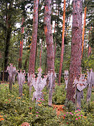
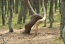
The Dancing Forest
The forest is perhaps one of the most famous sights at the Curonian Spit planted in 60s of the last century that has taken bizarre forms since then. These twists really remind people frozen when dancing responsible for its name. The forest is located on the km 37 of the national park.
It is most interesting that not the entire pine forest on the Spit is unusually shaped. There is the clear border between the usual and twisting form of trees. The site of the «dancing» array has long been the subject of study of biologists; however they have not found the rooting reasons for the phenomena. There is a theory to look for the cause in specific natural conditions at the Curonian Spit that caused such genetic changes in the single floral site. It is also possible that this is resulting from some particular virus or insects.
However, local people believe this anomaly is something mystical and they treat the «dancing forest» with special care suggesting some space energy in there. Anyway, this is still a mystery attracting lovers of natural secrets year by year.
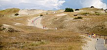
Epha Sand Dune
Having reached the km 42 of the Curonian Spit, research the sandy terrain named after FranzEpha, the dune inspector during the period of East Prussia. Such a title would confuse people though a person who held this position was in the great respect by locals. The settlements could have been covered with sand without the proper dune management and this occurred repeatedly throughout the history of the Spit.
The stunning view of all «worlds» of the Curonian Spit opens from this height named in honor of the inspector for his merits. Dunes fortified with greenery, beaches, birch and pine forests and the unique view of the Baltic Sea appear to you.
History of the Curonian Spit
Looking at the golden sand, you will want to go barefoot, though it is strictly forbidden under specific conditions of the Curonian Spit. A careless step may ruin the fragile ecosystem of this unique corner of nature and locals know of that since long. Therefore, you can move around the sand only along specially made paths constructed by volunteers, enthusiasts and park personnel.
This strip of land was formed by natural alluviation and it happened relatively recently in terms of historical paradigm. The name of the area is associated with the Curonians, the pagan tribe that lived here in the 9th century AD. These people were known for their special attitude to the forest. They believed the forest was sacred, they danced around it and worshiped gods. Vojtĕch Adalbertus, the Prague missionary who ignored this rule and stepped into the forbidden grove, paid with his life.
The Vikings who settled here in the 12th century failed to have special feelings for flora and fauna, though forests of the Curonian Spit survived their reign. The real danger to local pines and birches appeared later, from about the 16th century, when the Prussian kings began to rule on those lands. They hunted in former sacred woods changing to forest devastation, and they never through of drastic consequences. Though, they took no long to occur: having no vegetation barriers, sands began to open an attack to settlements.
The results of vandal clearance resulted in escape of residents and the launch of centuries-long battle for preservation of the Curonian Spit. Since then, people tend to plant bushes herein, the dune behavior is controlled by foresters and scientists, surveyors elaborately monitor to strain the sands. The Soviet specialists followed these activities to keep on reserve the spit within the post-World War II period. Since 2000, the area has been acknowledged as the World Heritage Site protected by UNESCO.
How to get to the Curonian Spit from Kaliningrad
Kaliningrad lies in 30 km distance to the Curonian Spit that is easy to cover. You can do this in two different ways:
- in this direction, a direct Kaliningrad-Klaipeda bus runs from the South Railway Station that takes you to any section of the spit, whether it is the Lithuanian or Russian side. Also, you can trip by the road from the regional center to Zelenogradsk, one of two federal resort towns that also requires to be visited when you stay here. As you see this beautiful coastal town, you can get to the final destination by taking a bus to Morskoe village;
- a car rent is the simplest and quickest way to get to the place. You can rent a car any time by contacting the hotel manager. The trip takes about half an hour and the car rent will be extra paid.
It should be noted that the entrance to the Curonian Spit is restricted by the fee of 150 rubles per person and 300 rubles per vehicle. The fee will be twice lower for schoolchildren and pensioners by 50% discount, and the access is free for disabled people and children under the age of 12.
| Curonian Spit National Park | |
|---|---|
| Куршская коса (Russian) Also: Kurshskaya Kosa |
|

Curonian Spit |
|
|
Location of Park |
|
| Location | Kaliningrad Oblast |
| Nearest city | Kaliningrad |
| Coordinates | 55°08′N 20°48′E / 55.133°N 20.800°ECoordinates: 55°08′N 20°48′E / 55.133°N 20.800°E |
| Area | 6,621 hectares (16,361 acres; 66 km2; 26 sq mi) |
| Established | 1987 |
| Governing body | Ministry of Natural Resources and Environment (Russia) |

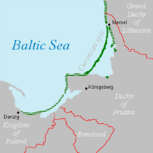
Curonian Spit National Park (Russian: Куршская коса) (Also: Kurshskaya Kosa) covers the Russian-owned southern 41 km of the 98 km long, curved Curonian Spit – a type of depositional sandbar. The spit separates the salt-water Baltic Sea (on the west) from the freshwater Curonian Lagoon to the east. The southern portion of the spit lies within Zelenogradsky District in Kaliningrad Oblast, Russia; the northern portion lies within southwestern Lithuania. It is a UNESCO World Heritage Site shared by the two countries.[1]
Topography[edit]
The foundations of the spit were created about 15,000 BCE as the receding glaciers left the Baltic Sea behind, and the sand dunes of the Curonian built on the glacial moraine.[2] The actions of sea and wind build large dunes, which average 35 meters on the spit. The area is one of high biodiversity due to the many different ecological communities in close proximity to each other: beach, dune ridge, wetlands of various types, meadows and forests. The Curonian Spit is the second longest spit in the world, after the 110-km long Arabat Spit in the Sea of Azov. The park follows the spit from the Sambian Peninsula in the south to the border with Lithuania about 40 km north; its width varies from 0.4 to 4 km.[3] The water in the lagoon averages 3.7 meters in depth, and the water level of the lagoon is about 12 cm above that of the Baltic.
-

Curonian Spit (and Curonian Lagoon) from Space, 2006
-

Beach in Kurshskaya Kosa National Park
-

Swan Lake, Kurshskaya Kosa National Park
-

Map of Curonian Lagoon, spit to the west
-

-
Epha Dune, aerial view


Plants and animals[edit]
Birds and waterfowl are abundant, as the park has abundant wetlands and is on major migratory routes. 262 species of birds have been recorded in the park, and 100 are known to nest and breed in the territory. The park is also home to 46 species of mammals, including elk, European roe deer, wild boar, fox, marten, raccoon dog, badger, hare, red squirrel, and beaver. The park has recorded over 290 species of terrestrial vertebrates, representing 80% of the species found in the Kaliningrad region. Plant life is similarly varied: 889 species, hybrids, varieties and forms of wild vascular plants of 398 genera and 111 families.[2]
See also[edit]
- Curonian Spit National Park (Lithuania) — Neighboring park to the north in Lithuania
- Protected areas of Russia
- List of spits
- Nature reserves of Russia (zapovedniks)
References[edit]
- ^ «Kurshskaya Kosa (in Russian)». FGBU National Park Kurshkaya Kosa. Retrieved December 29, 2015.
- ^ a b «Kurshskaya Kosa — Overview (in Russian)». FGBU National Park Kurshkaya Kosa. Retrieved December 29, 2015.
- ^ «Curonian Spit». UNESCO. Retrieved December 29, 2015.
External links[edit]
- UNESCO World Heritage Site — Curonian Spit listing
- Official Kurshskaya Kosa Guide — App for iPhone or Android
![]()
Complete the text. Write three questions about the Curonian Spit.
meters, unique, reach, during, long
The Curonian Spit is situated between Russia and Lithuania. It is 98 km … . The fantastic combination of forests, beach and desert makes this place … . The Curonian Spit is home to the highest moving sand dunes in Europe. Their average height is 35 … . Some of them … a height of 60 meters. Between 10 and 20 million birds fly over the Spit … spring and autumn migration. Most of them stop to have a rest on the Curonian Spit.


![]()
reshalka.com
Английский язык ENJOY ENGLISH Английский с удовольствием 6 класс Биболетова. UNIT 1. HOMEWORK. Номер №7
Решение
Перевод задания
Дополнить текст. Напишите три вопроса о Куршской косе.
метры, уникальный, досягаемость, в течение, длинна
Куршская коса расположена между Россией и Литвой. Ее … 98 км. Фантастическое сочетание леса, пляжа и пустыни делает это место … . На Куршской косе находятся самые высокие подвижные песчаные дюны в Европе. Их средняя высота 35 … . Некоторые из них … высоты 60 метров. … весенне−осенней миграции над косой пролетают от 10 до 20 миллионов птиц. Большинство из них останавливаются отдохнуть на Куршской косе.
ОТВЕТ
The Curonian Spit is situated between Russia and Lithuania. It is 98 km long. The fantastic combination of forests, beach and desert makes this place unique. The Curonian Spit is home to the highest moving sand dunes in Europe. Their average height is 35 meters. Some of them reach a height of 60 meters. Between 10 and 20 million birds fly over the Spit during spring and autumn migration. Most of them stop to have a rest on the Curonian Spit.
Перевод ответа
Куршская коса расположена между Россией и Литвой. Ее длина 98 км. Фантастическое сочетание леса, пляжа и пустыни делает это место уникальным. На Куршской косе находятся самые высокие подвижные песчаные дюны в Европе. Их средняя высота 35 метров. Некоторые из них достигают высоты 60 метров. Во время весенне−осенней миграции над косой пролетают от 10 до 20 миллионов птиц. Большинство из них останавливаются отдохнуть на Куршской косе.
Презентация, доклад по английскому языку Куршская коса
Содержание
-
1.
Презентация по английскому языку Куршская коса -
2.
The Curonian Spit is a 98 km -
3.
The Curonian Spit is home to the -
4.
Between 10 and 20 million birds -
5.
The Curonian Spit is really popular among
The Curonian Spit is a 98 km long, thin sand-dune spit. It separates the Curonian Lagoon from the Baltic Sea. The fantastic combination of forests, beach and desert makes this place unique.
-
Главная
-
Английский язык
-
Презентация по английскому языку Куршская коса
Слайд 1The Curonian Spit
Missyura Tatiana 7a

Слайд 2
The Curonian Spit is a 98 km long, thin sand-dune spit.
It separates the Curonian Lagoon from the Baltic Sea. The fantastic combination of forests, beach and desert makes this place unique.

Слайд 3The Curonian Spit is home to the highest moving sand dunes
in Europe. Their average height is 35 metres, but some reach a height of 60 metres.

Слайд 4 Between 10 and 20 million birds fly over the spit
during spring and autumn migrations. Most of them stop to have a rest on the Curonian Spit.

Слайд 5The Curonian Spit is really popular among tourists and local Kaliningrad
citizens. Wildlife and nature of the spit need protection and care.

Похожие презентации
| UNESCO World Heritage Site | |
|---|---|
 |
|
| Location | Klaipėda County, Lithuania Kaliningrad Oblast, Russia |
| Criteria | Cultural: v |
| Reference | 994 |
| Inscription | 2000 (24th Session) |
| Area | 33,021 ha |
| Coordinates | 55°16′28″N 20°58′15″E / 55.27444°N 20.97083°ECoordinates: 55°16′28″N 20°58′15″E / 55.27444°N 20.97083°E |
|
Location of the Curonian Spit on the Baltic Sea coast of Northern Europe |

The Curonian (Courish) Spit (Lithuanian: Kuršių nerija; Russian: Ку́ршская коса́ (Kurshskaya kosa); German: Kurische Nehrung, ![]() German pronunciation (help·info); Latvian: Kuršu kāpas) is a 98-kilometre (61 mi) long, thin, curved sand-dune spit that separates the Curonian Lagoon from the Baltic Sea coast. Its southern portion lies within Kaliningrad Oblast, Russia, and its northern within southwestern Klaipėda County, Lithuania. It is a UNESCO World Heritage Site shared by Lithuania and Russia.
German pronunciation (help·info); Latvian: Kuršu kāpas) is a 98-kilometre (61 mi) long, thin, curved sand-dune spit that separates the Curonian Lagoon from the Baltic Sea coast. Its southern portion lies within Kaliningrad Oblast, Russia, and its northern within southwestern Klaipėda County, Lithuania. It is a UNESCO World Heritage Site shared by Lithuania and Russia.
Geography[edit]

The Curonian Spit stretches from the Sambia Peninsula on the south to its northern tip next to a narrow strait, across which is the port city of Klaipėda on the mainland of Lithuania. The northern 52 km (32 mi) long stretch of the Curonian Spit peninsula belongs to Klaipėda County, Lithuania, while the rest is part of the Kaliningrad Oblast, Russia. The width of the spit varies from a minimum of 400 m (1,300 ft) in Russia (near the village of Lesnoy) to a maximum of 3,800 m (12,500 ft; 2.4 mi) in Lithuania (just north of Nida).
Geologic history[edit]
The Curonian Spit was formed about 3rd millennium BC.[1] A glacial moraine served as its foundation; winds and sea currents later contributed enough sand to raise and keep the formation above sea level.[1]
The existence of this narrow shoal is inherently threatened by the natural processes that govern shoreline features.[2] It depends on a dynamic balance between sand transport and deposition. If (hypothetically) the source area to the south-west were cut off, say, by a large port construction with a pier, the spit would erode and eventually disappear. It is thus a geologically speaking ephemeral coast element. The most likely development, however, is that the shallow bay inside the Curonian Spit will eventually fill up with sediment, thus creating new land.
Human history[edit]
Mythology[edit]
According to folk etymology for the name of Neringa Municipality, there was a giantess girl named Neringa, who formed the Curonian Spit and helped fishermen.[3]
The Medieval period[edit]
From c. 800 to 1016, the Spit was the location of Kaup, a major pagan trading centre which has not been excavated yet. The Teutonic Knights occupied the area in the 13th century, building their castles at Memel (1252), Neuhausen (1283), and at Rossitten (1372). In 1454, King Casimir IV Jagiellon incorporated the region to the Kingdom of Poland upon the request of the anti-Teutonic Prussian Confederation.[4] After the subsequent Thirteen Years’ War (1454–1466), the spit became a part of Poland as a fief held by the Teutonic Knights,[5] and thus located within the Polish–Lithuanian union, later elevated to the Polish–Lithuanian Commonwealth. The spit may have been the home of the last living speaker of now-extinct Old Prussian, one of the Baltic languages.[6]
Kursenieki habitation[edit]
Significant human impacts on the area began in the 16th century.[1] From the 18th century, it was part of the Kingdom of Prussia. Deforestation of the spit due to overgrazing, timber harvesting, and building of boats for the Battle of Gross-Jägersdorf in 1757 led to the dunes taking over the spit and burying entire villages. Alarmed by these problems, the Prussian government sponsored large-scale revegetation and reforestation efforts, which started in 1825. Other sources credit George David Kuwert, the owner of a post station in Nida in the late 19th century, with beginning the spit’s reforestation.[citation needed] Owing to these efforts, much of the spit is now covered with forests.
In the 19th century the Curonian Spit was inhabited primarily by Kursenieki, with a significant German minority in the south and a Lithuanian minority in the north. The population of Kursenieki eventually dwindled due to assimilation and other reasons; it is close to non-existent these days and had been even before 1945, when the spit had become ethnic German.[citation needed]
Artists’ colony[edit]

From the late 19th century, the dune landscape around Nidden (Nida) became popular with landscape and animal painters from the Kunstakademie Königsberg arts school. The local inn of Herman Blode was the nucleus of the expressionist artists’ colony (Künstlerkolonie Nidden). Lovis Corinth stayed here in 1890, followed by artists such as Max Pechstein, Alfred Lichtwark, Karl Schmidt-Rottluff, and Alfred Partikel.[7] Painters from Königsberg such as Julius Freymuth and Eduard Bischoff visited the area, as did poets like Ernst Wiechert and Carl Zuckmayer.[7] Other guests included Ernst Kirchner, Ernst Mollenhauer, Franz Domscheit, and Herrmann Wirth. The painters usually took accommodations at Blode’s hotel, and left some of their works with him. Some also built their own residences in the vicinity.
20th century[edit]

Curonian Spit in Kaliningrad Oblast, Russia
Until the 20th century, most people in the area made their living by fishing. From 1901 to 1946 the village of Rossitten, now Rybachy, became the site of the pioneering Rossitten Bird Observatory, the world’s first, founded by German ornithologist Johannes Thienemann there because of the Spit’s importance as a bird migration corridor.
After World War I, Nidden, together with the northern half of the Curonian Spit became part of the Klaipėda Region according to the 1919 Treaty of Versailles and was annexed by Lithuania in 1923. Officially renamed Nida, the village nevertheless remained a German-majority settlement – the border with the remaining East Prussian half of the Spit lay only a few kilometres to the south.
In 1929 Nobel Prize-winning writer Thomas Mann visited Nida while on holiday in nearby Rauschen and decided to have a summer house erected on a hill above the Lagoon, mocked as Uncle Tom’s Cabin (Onkel Toms Hütte) by locals. He and his family spent the summers of 1930–1932 in the thatched cottage; parts of the epic novel Joseph and His Brothers (Joseph und seine Brüder) were written here. Threatened by the Nazis, Mann left Germany after Hitler’s Machtergreifung in 1933 and never returned to Nida. After the Klaipėda Region was again annexed by Nazi Germany in 1939, his house was seized at the behest of Hermann Göring and served as a recreation home for Luftwaffe officers.
Following World War II, the German-occupied Lithuanian part of the spit was restored to Lithuania, while the remainder fell to Russia. The German population was expelled after the war by the occupying Soviet forces in accordance with the Potsdam Agreement. Like elsewhere in present-day Kaliningrad Oblast, the assimilation of the territory and colonization by Russian settlers was completed by changing the historic German toponyms to Russian ones throughout the Russian-controlled part of the Spit.
Today[edit]
After the breakup of the Soviet Union, tourism flourished; many Germans, mostly the descendants of the inhabitants of the area, choose the Curonian Spit (especially Nida, as no visas are needed for Germans in Lithuania) as their holiday destination.
Kursenieki[edit]
While today the Kursenieki, also known as Kuršininkai, are a nearly extinct Baltic ethnic group living along the Curonian Spit, in 1649 Kuršininkai settlement spanned from Memel (Klaipėda) to Gdańsk. The Kuršininkai were eventually assimilated by the Germans, except along the Curonian Spit where some still live. The Kuršininkai were considered Latvians until after World War I, when Latvia gained independence from the Russian Empire, a consideration based on linguistic arguments. This was the rationale for Latvian claims over the Curonian Spit, Memel and other territories of Prussia, which would be later dropped.
-
-

-

Old cemetery in Nida
-

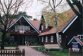
Small inn and cafe in Nida
-
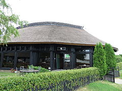
Fish restaurant in Nida


Current state[edit]


The Curonian Spit is home to the highest moving (drifting) sand dunes in Europe. Their average height is 35 metres (115 ft), but some attain a height of 60 metres (200 ft). Several ecological communities are present on and near the Spit, from its outer beaches to dune ridges, wetlands, meadows, and forests.[8] Its location on the East Atlantic Flyway means it is frequently visited by migratory waterfowl. Between 10 and 20 million birds fly over the feature during spring and fall migrations, and many pause to rest or breed there.[8]
Both the Russian and Lithuanian parts of the spit are national parks.
The settlements of the Curonian Spit (from north to south) are:
- Smiltynė
- Alksnynė
- Juodkrantė
- Pervalka
- Preila
- Nida
- Morskoe
- Rybachy
- Lesnoy
The first six are on the Lithuanian side, while the last three are on the Russian side. The Russian side of the Curonian Spit belongs to Zelenogradsky District of the Kaliningrad Oblast, while the Lithuanian side is partitioned among Klaipėda city municipality and Neringa municipality in Klaipėda County.
There is a single road that traverses the whole length of the Curonian Spit. In the Russian side it goes to Zelenogradsk, while on the Lithuanian side it goes to Smiltynė. The spit is not connected to mainland Lithuania. Car ferries provide a transportation link between Smiltynė, located on the spit, and the port town of Klaipėda.
Since 2000, the Curonian Spit has been on UNESCO’s World Heritage List under cultural criteria «V» («an outstanding example of a traditional human settlement, land-use, or sea-use which is representative of a culture […], or human interaction with the environment especially when it has become vulnerable under the impact of irreversible change»).
As of March 2012, there was a demand to tear down a number of homes on the Curonian Spit. These homes are owned by people who were given permits to build by corrupt local government[specify] officials. The demand to tear the homes down is based on the fact that the Spit is a UN World Heritage Site and the only structures that were to be allowed outside official settlements were fishing shacks.[9]
Tourism[edit]
The largest town on the spit is Nida in Lithuania, a popular holiday resort, mostly frequented by Lithuanian and German tourists. The western shoreline of Curonian Spit is the site of beaches for tourists.
Parnidis dune and sundial[edit]
Parnidis sand dune, subjected to drift by harsh winds, is rising up to 52 metres (171 ft) above sea level. Local residents believe that the name Parnidis comes from the phrase meaning «passed across Nida», because this wind-blown dune has several times passed through the village of Nida. Scientists estimated that each person climbing or descending on the steep dune slopes moves several tons of sand, so hikers are allowed to climb only in designated paths.
There is a granite sundial built on Parnidis dune in 1995 that accurately shows the time. The sundial was rebuilt in 2011 following storm damage. The sundial is a stone pillar 13.8 metres (45 ft) high and weighing 36 tonnes (35 long tons; 40 short tons). It consists in small steps covered with granite slabs, carved with hour and half-hour notches, as well as one notch for each month, and four additional notches for solstices and equinoxes. From the astronomical point of view Parnidis dune is an ideal place for the sundial in Lithuania.[10]
Environmental concerns[edit]

The Curonian Spit is known for its fine sandy beaches (Nida, Lithuania).
There are environmental concerns related to the Curonian Spit, which is often promoted as a refuge of clean nature.
Due to the importance of tourism and fishing for the regional economy, pollution of sea and coastlines may have disastrous effects for the area as the unique nature and the economy would be damaged.
Sand dunes near Nida, Lithuania
The construction of an offshore drilling facility (the Kravtsovskoye (D-6) oilfield) in the territorial waters of Russia, 22.5 km (14.0 mi) from the coastline of the Curonian Spit raised concerns over possible oil spills. Between 2002 and 2005 local environmentalists in Kaliningrad Oblast[11] and Lithuania[12] protested against Lukoil’s plans to exploit the oilfield, objecting to the possible great damage to the environment and tourism (a vital source of income in the area) in case of oil leakage. These concerns did not engender support in the government of Russia. They were, however, supported by the government of Lithuania. The oilfield is about 4 km (2.5 mi) from the boundary of Lithuanian territorial waters; the prevailing northward currents means that the Lithuanian coastlines would receive much potential damage in case of leakage. Opposition to the operation of D-6 met little international support, and the oil platform was opened in 2004. During the first decade of the 21st century the two states agreed to a joint environmental impact assessment of the D-6 project, including plans for oil spill mitigation.[13] The assessment and mitigation project had not been completed as of 2010.[13]
Another concern is that increased tourism destroys the very nature that attracts it. For this reason, protective measures have been taken, such as banning tourists from hiking in certain areas of the spit.
Natural hazards are more dangerous in the Curonian Spit than elsewhere in Lithuania or the Kaliningrad Oblast. For example, storms tend to be stronger there. Due to the importance of trees in preventing soil erosion, forest fires that happen in summer are more dangerous to the ecology.
See also[edit]
- Kuršių Nerija National Park
- Curonian Spit National Park (Russia)
- Vecekrugas dune
References[edit]
- ^ a b c «LANDSCAPE». Kuršių Nerija National Park. Archived from the original on 2012-05-30. Retrieved 2021-03-28.
- ^ «Curonian Spit». UNESCO. Retrieved 2010-06-15.
- ^ Gitana Kazimieraitienė, Legendos pasakoja. Lietuvos geografiniai objektai, Kaunas, „Šviesa“, 2008, ISBN 5430047694 (online)
- ^ Górski, Karol (1949). Związek Pruski i poddanie się Prus Polsce: zbiór tekstów źródłowych (in Polish). Poznań: Instytut Zachodni. p. 54.
- ^ Górski, pp. 96–97, 214–215
- ^ Krickus, Richard J. (2002). The Kaliningrad question. Rowman & Littlefield. p. 17. ISBN 978-0-7425-1705-9. Retrieved 2019-08-20.
- ^ a b Weise, p. 159
- ^ a b «Curonian Spit» (PDF). UNESCO. Archived from the original (PDF) on 2011-07-22. Retrieved 2010-06-15.
- ^ «Lithuania:The Battle for the Curonian Spit». Deutsche Welle. Retrieved 2012-10-03.
- ^ «Parnidis Dune with Sun Clock – Calendar». Lithuania.travel. Archived from the original on 2016-03-24. Retrieved 2016-04-25.
- ^ [1] Archived October 9, 2007, at the Wayback Machine
- ^ [2] Archived January 11, 2006, at the Wayback Machine
- ^ a b «32COM 7B.98 – Curonian Spit (Lithuania / Russian Federation) (C 994)». UNESCO World Heritage Committee. Retrieved 2010-06-15.
External links[edit]
- UNESCO World Heritage Site Curonian Spit
- Kursiu Nerija National Park (in Lithuania) Archived 2015-05-14 at the Wayback Machine
- National Park Kurshskaya Kosa (in Russia)
- Rybachy Biological Station, Russian Academy of Sciences
- Curonian Spit at Natural Heritage Protection Fund
| UNESCO World Heritage Site | |
|---|---|
|
|
| Location | Klaipėda County, Lithuania Kaliningrad Oblast, Russia |
| Criteria | Cultural: v |
| Reference | 994 |
| Inscription | 2000 (24th Session) |
| Area | 33,021 ha |
| Coordinates | 55°16′28″N 20°58′15″E / 55.27444°N 20.97083°ECoordinates: 55°16′28″N 20°58′15″E / 55.27444°N 20.97083°E |
|
Location of the Curonian Spit on the Baltic Sea coast of Northern Europe |
The Curonian (Courish) Spit (Lithuanian: Kuršių nerija; Russian: Ку́ршская коса́ (Kurshskaya kosa); German: Kurische Nehrung, ![]() German pronunciation (help·info); Latvian: Kuršu kāpas) is a 98-kilometre (61 mi) long, thin, curved sand-dune spit that separates the Curonian Lagoon from the Baltic Sea coast. Its southern portion lies within Kaliningrad Oblast, Russia, and its northern within southwestern Klaipėda County, Lithuania. It is a UNESCO World Heritage Site shared by Lithuania and Russia.
German pronunciation (help·info); Latvian: Kuršu kāpas) is a 98-kilometre (61 mi) long, thin, curved sand-dune spit that separates the Curonian Lagoon from the Baltic Sea coast. Its southern portion lies within Kaliningrad Oblast, Russia, and its northern within southwestern Klaipėda County, Lithuania. It is a UNESCO World Heritage Site shared by Lithuania and Russia.
Geography[edit]
The Curonian Spit stretches from the Sambia Peninsula on the south to its northern tip next to a narrow strait, across which is the port city of Klaipėda on the mainland of Lithuania. The northern 52 km (32 mi) long stretch of the Curonian Spit peninsula belongs to Klaipėda County, Lithuania, while the rest is part of the Kaliningrad Oblast, Russia. The width of the spit varies from a minimum of 400 m (1,300 ft) in Russia (near the village of Lesnoy) to a maximum of 3,800 m (12,500 ft; 2.4 mi) in Lithuania (just north of Nida).
Geologic history[edit]
The Curonian Spit was formed about 3rd millennium BC.[1] A glacial moraine served as its foundation; winds and sea currents later contributed enough sand to raise and keep the formation above sea level.[1]
The existence of this narrow shoal is inherently threatened by the natural processes that govern shoreline features.[2] It depends on a dynamic balance between sand transport and deposition. If (hypothetically) the source area to the south-west were cut off, say, by a large port construction with a pier, the spit would erode and eventually disappear. It is thus a geologically speaking ephemeral coast element. The most likely development, however, is that the shallow bay inside the Curonian Spit will eventually fill up with sediment, thus creating new land.
Human history[edit]
Mythology[edit]
According to folk etymology for the name of Neringa Municipality, there was a giantess girl named Neringa, who formed the Curonian Spit and helped fishermen.[3]
The Medieval period[edit]
From c. 800 to 1016, the Spit was the location of Kaup, a major pagan trading centre which has not been excavated yet. The Teutonic Knights occupied the area in the 13th century, building their castles at Memel (1252), Neuhausen (1283), and at Rossitten (1372). In 1454, King Casimir IV Jagiellon incorporated the region to the Kingdom of Poland upon the request of the anti-Teutonic Prussian Confederation.[4] After the subsequent Thirteen Years’ War (1454–1466), the spit became a part of Poland as a fief held by the Teutonic Knights,[5] and thus located within the Polish–Lithuanian union, later elevated to the Polish–Lithuanian Commonwealth. The spit may have been the home of the last living speaker of now-extinct Old Prussian, one of the Baltic languages.[6]
Kursenieki habitation[edit]
Significant human impacts on the area began in the 16th century.[1] From the 18th century, it was part of the Kingdom of Prussia. Deforestation of the spit due to overgrazing, timber harvesting, and building of boats for the Battle of Gross-Jägersdorf in 1757 led to the dunes taking over the spit and burying entire villages. Alarmed by these problems, the Prussian government sponsored large-scale revegetation and reforestation efforts, which started in 1825. Other sources credit George David Kuwert, the owner of a post station in Nida in the late 19th century, with beginning the spit’s reforestation.[citation needed] Owing to these efforts, much of the spit is now covered with forests.
In the 19th century the Curonian Spit was inhabited primarily by Kursenieki, with a significant German minority in the south and a Lithuanian minority in the north. The population of Kursenieki eventually dwindled due to assimilation and other reasons; it is close to non-existent these days and had been even before 1945, when the spit had become ethnic German.[citation needed]
Artists’ colony[edit]
From the late 19th century, the dune landscape around Nidden (Nida) became popular with landscape and animal painters from the Kunstakademie Königsberg arts school. The local inn of Herman Blode was the nucleus of the expressionist artists’ colony (Künstlerkolonie Nidden). Lovis Corinth stayed here in 1890, followed by artists such as Max Pechstein, Alfred Lichtwark, Karl Schmidt-Rottluff, and Alfred Partikel.[7] Painters from Königsberg such as Julius Freymuth and Eduard Bischoff visited the area, as did poets like Ernst Wiechert and Carl Zuckmayer.[7] Other guests included Ernst Kirchner, Ernst Mollenhauer, Franz Domscheit, and Herrmann Wirth. The painters usually took accommodations at Blode’s hotel, and left some of their works with him. Some also built their own residences in the vicinity.
20th century[edit]
Curonian Spit in Kaliningrad Oblast, Russia
Until the 20th century, most people in the area made their living by fishing. From 1901 to 1946 the village of Rossitten, now Rybachy, became the site of the pioneering Rossitten Bird Observatory, the world’s first, founded by German ornithologist Johannes Thienemann there because of the Spit’s importance as a bird migration corridor.
After World War I, Nidden, together with the northern half of the Curonian Spit became part of the Klaipėda Region according to the 1919 Treaty of Versailles and was annexed by Lithuania in 1923. Officially renamed Nida, the village nevertheless remained a German-majority settlement – the border with the remaining East Prussian half of the Spit lay only a few kilometres to the south.
In 1929 Nobel Prize-winning writer Thomas Mann visited Nida while on holiday in nearby Rauschen and decided to have a summer house erected on a hill above the Lagoon, mocked as Uncle Tom’s Cabin (Onkel Toms Hütte) by locals. He and his family spent the summers of 1930–1932 in the thatched cottage; parts of the epic novel Joseph and His Brothers (Joseph und seine Brüder) were written here. Threatened by the Nazis, Mann left Germany after Hitler’s Machtergreifung in 1933 and never returned to Nida. After the Klaipėda Region was again annexed by Nazi Germany in 1939, his house was seized at the behest of Hermann Göring and served as a recreation home for Luftwaffe officers.
Following World War II, the German-occupied Lithuanian part of the spit was restored to Lithuania, while the remainder fell to Russia. The German population was expelled after the war by the occupying Soviet forces in accordance with the Potsdam Agreement. Like elsewhere in present-day Kaliningrad Oblast, the assimilation of the territory and colonization by Russian settlers was completed by changing the historic German toponyms to Russian ones throughout the Russian-controlled part of the Spit.
Today[edit]
After the breakup of the Soviet Union, tourism flourished; many Germans, mostly the descendants of the inhabitants of the area, choose the Curonian Spit (especially Nida, as no visas are needed for Germans in Lithuania) as their holiday destination.
Kursenieki[edit]
While today the Kursenieki, also known as Kuršininkai, are a nearly extinct Baltic ethnic group living along the Curonian Spit, in 1649 Kuršininkai settlement spanned from Memel (Klaipėda) to Gdańsk. The Kuršininkai were eventually assimilated by the Germans, except along the Curonian Spit where some still live. The Kuršininkai were considered Latvians until after World War I, when Latvia gained independence from the Russian Empire, a consideration based on linguistic arguments. This was the rationale for Latvian claims over the Curonian Spit, Memel and other territories of Prussia, which would be later dropped.
-
-
-
Old cemetery in Nida
-
Small inn and cafe in Nida
-
Fish restaurant in Nida
Current state[edit]
The Curonian Spit is home to the highest moving (drifting) sand dunes in Europe. Their average height is 35 metres (115 ft), but some attain a height of 60 metres (200 ft). Several ecological communities are present on and near the Spit, from its outer beaches to dune ridges, wetlands, meadows, and forests.[8] Its location on the East Atlantic Flyway means it is frequently visited by migratory waterfowl. Between 10 and 20 million birds fly over the feature during spring and fall migrations, and many pause to rest or breed there.[8]
Both the Russian and Lithuanian parts of the spit are national parks.
The settlements of the Curonian Spit (from north to south) are:
- Smiltynė
- Alksnynė
- Juodkrantė
- Pervalka
- Preila
- Nida
- Morskoe
- Rybachy
- Lesnoy
The first six are on the Lithuanian side, while the last three are on the Russian side. The Russian side of the Curonian Spit belongs to Zelenogradsky District of the Kaliningrad Oblast, while the Lithuanian side is partitioned among Klaipėda city municipality and Neringa municipality in Klaipėda County.
There is a single road that traverses the whole length of the Curonian Spit. In the Russian side it goes to Zelenogradsk, while on the Lithuanian side it goes to Smiltynė. The spit is not connected to mainland Lithuania. Car ferries provide a transportation link between Smiltynė, located on the spit, and the port town of Klaipėda.
Since 2000, the Curonian Spit has been on UNESCO’s World Heritage List under cultural criteria «V» («an outstanding example of a traditional human settlement, land-use, or sea-use which is representative of a culture […], or human interaction with the environment especially when it has become vulnerable under the impact of irreversible change»).
As of March 2012, there was a demand to tear down a number of homes on the Curonian Spit. These homes are owned by people who were given permits to build by corrupt local government[specify] officials. The demand to tear the homes down is based on the fact that the Spit is a UN World Heritage Site and the only structures that were to be allowed outside official settlements were fishing shacks.[9]
Tourism[edit]
The largest town on the spit is Nida in Lithuania, a popular holiday resort, mostly frequented by Lithuanian and German tourists. The western shoreline of Curonian Spit is the site of beaches for tourists.
Parnidis dune and sundial[edit]
Parnidis sand dune, subjected to drift by harsh winds, is rising up to 52 metres (171 ft) above sea level. Local residents believe that the name Parnidis comes from the phrase meaning «passed across Nida», because this wind-blown dune has several times passed through the village of Nida. Scientists estimated that each person climbing or descending on the steep dune slopes moves several tons of sand, so hikers are allowed to climb only in designated paths.
There is a granite sundial built on Parnidis dune in 1995 that accurately shows the time. The sundial was rebuilt in 2011 following storm damage. The sundial is a stone pillar 13.8 metres (45 ft) high and weighing 36 tonnes (35 long tons; 40 short tons). It consists in small steps covered with granite slabs, carved with hour and half-hour notches, as well as one notch for each month, and four additional notches for solstices and equinoxes. From the astronomical point of view Parnidis dune is an ideal place for the sundial in Lithuania.[10]
Environmental concerns[edit]
The Curonian Spit is known for its fine sandy beaches (Nida, Lithuania).
There are environmental concerns related to the Curonian Spit, which is often promoted as a refuge of clean nature.
Due to the importance of tourism and fishing for the regional economy, pollution of sea and coastlines may have disastrous effects for the area as the unique nature and the economy would be damaged.
Sand dunes near Nida, Lithuania
The construction of an offshore drilling facility (the Kravtsovskoye (D-6) oilfield) in the territorial waters of Russia, 22.5 km (14.0 mi) from the coastline of the Curonian Spit raised concerns over possible oil spills. Between 2002 and 2005 local environmentalists in Kaliningrad Oblast[11] and Lithuania[12] protested against Lukoil’s plans to exploit the oilfield, objecting to the possible great damage to the environment and tourism (a vital source of income in the area) in case of oil leakage. These concerns did not engender support in the government of Russia. They were, however, supported by the government of Lithuania. The oilfield is about 4 km (2.5 mi) from the boundary of Lithuanian territorial waters; the prevailing northward currents means that the Lithuanian coastlines would receive much potential damage in case of leakage. Opposition to the operation of D-6 met little international support, and the oil platform was opened in 2004. During the first decade of the 21st century the two states agreed to a joint environmental impact assessment of the D-6 project, including plans for oil spill mitigation.[13] The assessment and mitigation project had not been completed as of 2010.[13]
Another concern is that increased tourism destroys the very nature that attracts it. For this reason, protective measures have been taken, such as banning tourists from hiking in certain areas of the spit.
Natural hazards are more dangerous in the Curonian Spit than elsewhere in Lithuania or the Kaliningrad Oblast. For example, storms tend to be stronger there. Due to the importance of trees in preventing soil erosion, forest fires that happen in summer are more dangerous to the ecology.
See also[edit]
- Kuršių Nerija National Park
- Curonian Spit National Park (Russia)
- Vecekrugas dune
References[edit]
- ^ a b c «LANDSCAPE». Kuršių Nerija National Park. Archived from the original on 2012-05-30. Retrieved 2021-03-28.
- ^ «Curonian Spit». UNESCO. Retrieved 2010-06-15.
- ^ Gitana Kazimieraitienė, Legendos pasakoja. Lietuvos geografiniai objektai, Kaunas, „Šviesa“, 2008, ISBN 5430047694 (online)
- ^ Górski, Karol (1949). Związek Pruski i poddanie się Prus Polsce: zbiór tekstów źródłowych (in Polish). Poznań: Instytut Zachodni. p. 54.
- ^ Górski, pp. 96–97, 214–215
- ^ Krickus, Richard J. (2002). The Kaliningrad question. Rowman & Littlefield. p. 17. ISBN 978-0-7425-1705-9. Retrieved 2019-08-20.
- ^ a b Weise, p. 159
- ^ a b «Curonian Spit» (PDF). UNESCO. Archived from the original (PDF) on 2011-07-22. Retrieved 2010-06-15.
- ^ «Lithuania:The Battle for the Curonian Spit». Deutsche Welle. Retrieved 2012-10-03.
- ^ «Parnidis Dune with Sun Clock – Calendar». Lithuania.travel. Archived from the original on 2016-03-24. Retrieved 2016-04-25.
- ^ [1] Archived October 9, 2007, at the Wayback Machine
- ^ [2] Archived January 11, 2006, at the Wayback Machine
- ^ a b «32COM 7B.98 – Curonian Spit (Lithuania / Russian Federation) (C 994)». UNESCO World Heritage Committee. Retrieved 2010-06-15.
External links[edit]
- UNESCO World Heritage Site Curonian Spit
- Kursiu Nerija National Park (in Lithuania) Archived 2015-05-14 at the Wayback Machine
- National Park Kurshskaya Kosa (in Russia)
- Rybachy Biological Station, Russian Academy of Sciences
- Curonian Spit at Natural Heritage Protection Fund
На основании Вашего запроса эти примеры могут содержать грубую лексику.
На основании Вашего запроса эти примеры могут содержать разговорную лексику.
Перевод «Куршская коса» на английский
Curonian Spit
Kurshskaya Kosa
Самая главная достопримечательность Литвы — это ее потрясающее балтийское побережье, особенно полоса белого песка под названием Куршская коса.
Lithuania’s foremost attraction is its stunning Baltic coastline, especially the unique silverr of white sand known as Curonian Spit.
Национальный парк «Куршская коса» — это неповторимое и незабываемое место!
The national park «Curonian Spit» is an amazing and unforgettable place!
На данный момент на территории национального парка «Куршская коса» на пляже находятся три тела животных», — говорится в сообщении.
At this point in the national Park «Kurshskaya Kosa» on the beach there are three bodies of animals», — stated in the message.
Нобелевский лауреат один из первых смог рассказать миру о чудесном уголке литовской Балтики — полуострове Куршская коса.
The Nobel Prize winner is one of the first ones who could tell the world about a wonderful part of Lithuanian Baltic the peninsula Kurshskaya Kosa.
Куршская коса является родиной самых высоких (дрейфующих) песчаных дюн в Европе.
Curonian Spit is home to the highest moving (drifting) sand dunes in Europe.
Куршская коса, созданная морем и ветром, представляет собой узкую песчаную полоску суши, где соленое море соседствует с пресноводным заливом.
Curonian spit, created by the sea and the wind, is a narrow sandy strip of land, where the salt sea is adjacent to the freshwater Bay.
Главным притяжением Литвы является потрясающая береговая линия Балтийского моря, особенно уникальная щепа белого песка, известная как Куршская коса.
Lithuania’s foremost attraction is its stunning Baltic coastline, especially the unique sliver of white sand known as Curonian Spit.
Национальный парк «Куршская коса» включён в Список как выдающийся культурный ландшафт.
National Park «Curonian Spit» included on the List as an outstanding cultural landscape.
Танцующий лес — одна из самых загадочных достопримечательностей национального парка «Куршская коса» в Калининградской области.
The dancing forest is one of the most mysterious sights of the Curonian Spit national park in the Kaliningrad region.
Место было выбрано не случайно, Куршская коса — это единственное место в Литве, где солнце заходит и восходит от поверхности воды.
This particular area was not randomly selected — Curonian Spit is the only place in Lithuania where the sunset and sunrise occurs from water surface.
Также альманах будет бесплатно распространяться музеями и инфо-центрами Национального парка «Куршская коса» (русская и литовская часть).
Also, the almanac will be distributed free of charge by museums and info centers of the Curonian Spit National Park (Russian and Lithuanian parts).
Не случайно Национальный парк «Куршская коса» внесен в реестр охраняемого природного наследия ЮНЕСКО.
It is not accidental that the National Park «Curonian Spit» is included in the register of the UNESCO protected natural heritage.
Наиболее густо Куршская коса была заселена в позднем неолите, в конце III тыс. до Р.Х.
The Curonian Spit was populated the best in the late neolith at the end of III millennium B.C.
Главная природная достопримечательность Клайпеды — уникальная Куршская коса, поделенная между Литвой и Россией.
The main natural attraction of Klaipeda is the unique Curonian Spit, divided between Lithuania and Russia.
Продолжается много усилий и продолжается работа по стабилизации дюн, чтобы сохранить этот постоянно меняющийся ландшафт для будущих поколений, и Куршская коса в настоящее время является объектом Всемирного наследия ЮНЕСКО.
Lots of effort and continuous dune stabilization work continues in order to preserve this ever-evolving landscape for future generations, and Curonian Spit is now a UNESCO World Heritage Site.
Северный 52-километровый участок полуострова Куршская коса относится к Литве, а остальная часть к Калининградской области, Россия.
The north 52km long elongate of the Curonian Spit cape belongs to Lithuania whereas the rest is the part of Kaliningrad Oblast in Russia.
Участие в совещании приняли главы прибрежных муниципалитетов, представители регионального министерства природы и экологии, управлений Росприроднадзора и Россельхознадзора, национального парка «Куршская коса» и калининградского зоопарка.
Participation the meeting was attended head of the coastal municipalities, representatives of the regional Ministry of nature and environment, departments of Rosprirodnadzor and Rosselkhoznadzor, the national Park of Curonian spit and Kaliningrad zoo.
Ожидать гораздо больше людей, когда солнце светит в выходные, так как Куршская коса находится недалеко от материка, и доступ из большого города (З-й по величине город в Литве, большие конечно, в относительном выражении, население 200к) Клайпеда.
Expect much more people when the sun is shining in the weekend, since Curonian Spit is easily accessible from the mainland, and the access is from a large city (3rd largest city in Lithuania, large of course in relative terms, population 200k) Klaipėda.
«Куршская коса настолько примечательна, что её надо увидеть, как Испанию или Италию, если вы хотите, чтобы в вашей душе запечатлелась такая дивная картина»
The Curonian Spit is so specific that one must necessarily see it in the same way as Spain or Italy in order to hold down this wonderful view in one’s soul.
Куршская коса, общая достопримечательность Литвы и Калининградской области, прошла во второй тур международного конкурса «Новые 7 чудес света».
Curonian Spit, the general sight of Lithuania and the Kaliningrad region, has passed into the second tour of the international competition «New 7 wonders of the world».
Результатов: 97. Точных совпадений: 97. Затраченное время: 121 мс
Documents
Корпоративные решения
Спряжение
Синонимы
Корректор
Справка и о нас
Индекс слова: 1-300, 301-600, 601-900
Индекс выражения: 1-400, 401-800, 801-1200
Индекс фразы: 1-400, 401-800, 801-1200
выбери сама .
Национальный парк «Куршская коса» расположился на узкой полоске суши, разделяя Балтийское море и пресноводный Куршский залив. Коренным народом, населявшим Куршскую косу в XI – XIIIвв. и давшим полуострову имя, были курши — одно из западно-балтских племен. Курши были язычниками, жили в гармонии с природой, а лес – свою обитель, считали святым и неприкосновенным.
Восемь маленьких поселений на берегу Куршского залива (три — на российской стороне и пять — на литовской) составляют лишь 3% всей пощади косы. На 44км Куршской косы, затерянный среди священных лесов и блуждающих дюн, находится маленький приграничный поселок Морское с населением 132 человека. Этот населенный пункт был выбран местом нашего размещения.
По приезду хозяйка гостевого дома накормила нас сытным ужином и мы отправились на прогулку к берегу Балтийского моря. Путь до моря длиной 800 метров пролегает через густой сосновый лес, в порывы свежего ветра вкрадываются запахи смолы и хвои.
Постоянно дующий ветер — характерная черта любой погоды на Куршской косе. Западные ветра интенсивно развеивают и перевеивают песчаные дюны. Со стороны моря Куршская коса защищена искусственной авандюной. Через защитно-пляжевый дюнный вал проложены деревянные мостки. В местах самовольных переходов на пляж образуются локальные очаги развеивания песков и процесс разрушения защитной дюны многократно ускоряется
Мы бродили по пустынному пляжу, подставляя лицо грубому соленому ветру. Суровые волны неустанно бросались на песчаный берег, закат оставлял янтарные брызги на пропитанном морем песке.
Утром мы арендовали велосипеды и отправились в путешествие по косе, перед стартом маршрута взбодрившись купанием в холодном Куршском заливе. С пляжа поселка Морское видны массивные холмы песчаных дюн, находящихся в вечном движении
В давние времена в 2км от современного поселка находилось селение Пилкопа, после появления орденского замка обретшее имя Нойштадт. Первый раз дюна похоронила под собой поселок в XVII веке. Жители переселились под прикрытие горы Петч, на территорию, которую сейчас занимает поселок Морское. Но вскоре и со склонов горы Петч началось движение песка, засыпав часть домов. Жители переселились ещё на 3 км севернее и назвали поселок Новый Пилкоппен.
Многие века по территории Куршской косы проходил почтовый и торговый путь. Когда европейский почтовый тракт был проложен по другому берегу Куршского залива, правительство Восточной Пруссии забросило борьбу с опустыниванием и ветровой эрозией на полуострове. Ситуация стала ещё более катастрофической. В начале XIX века усилилось поступление песка, снова засыпавшего дома, пастбища и огороды Нового Пилкоппена, село было обречено на гибель. Жители стали возвращаться обратно, на территорию нынешнего Морского.
Вернувшиеся на прежнее место к подножию дюны Петч, рыбаки недолго прожили спокойно: внезапно с угрожающей скоростью дюна снова начала наступление на жилища и в 1888г. достигла окраинных домов. Казалось, будущее деревни предопределено. Обеспокоенный судьбой села, за него вступился известный исследователь косы геолог Берендт. Было принято решение провести обширные лесонасаждения на передвигающихся в сторону села дюнах. Опасность засыпания песком была предотвращена благодаря деятельности немецкого инженера и ученого, дюнного инспектора Вильгельма Франца Эфа, автора проекта по облесению Куршской косы. Его имя носит дюна, у подножия которой расположен сейчас поселок Морское. Работы по закреплению движущихся песков на Куршской косе, в том числе в окрестностях Морского, продолжаются и в настоящее время.