Kemerovo is the heart of Kuzbass. – Кемерово – это сердце Кузбасса.
Coal mining has been its major industry since 1701. – Добыча угля является его основной промышленностью с 1701 года.
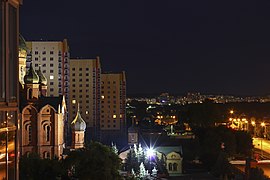
Kemerovo is not only an important industrial city but also a cultural centre with theatres, museums and monuments. – Кемерово не только важный промышленный центр, он является также культурным центром с театрами, музеями и памятниками.
Alexey Leonov, a cosmonaut, is the honorable citizen of Kemerovo. – Космонавт Алексей Леонов является почётным гражданином Кемерово.
Диалог о Кемерово на английском языке
– Kemerovo is a Siberian city, isn’t it? – Кемерово сибирский город, не так ли?
– Yes, it is. Kemerovo is the administrative center of Kemerovo Oblast. It is in West Siberia, in the major coal mining region of the Kuznetsk Basin. – Да. Кемерово – административный центр Кемеровской области. Это в Западной Сибири, в крупном угледобывающем районе Кузбасса.
– Is it a good place to live? – Здесь хорошо жить?
– Yes, it is. Kemerovo is a well-developed city. The only bad point is the climate. The winter is colder and one month longer than in central part of Russia. – Да. Кемерово – хорошо развитый город. Единственный недостаток – климат. Зима холоднее и на месяц дольше, чем в центральной части России.
– I see. How can I get there? – Понятно. Как туда доехать?
– By train or air. The city is served by the Kemerovo International Airport. – На поезде или самолёте. Город обслуживается международным аэропортом Кемерово.
– Are there any sights? – Есть там достопримечательности?
– Many cultural buildings are found in Kemerovo, such as Regional Drama Theater, Kuzbass Operetta Theater, Regional Museum of Fine Arts. – В Кемерово много культурных зданий, таких как областной театр драмы, музыкальный театр Кузбасса, областной музей изобразительных искусств.
It will be interesting to visit Park of Miracles, Botanical Garden, Yeti Park. – Интересно будет посетить Парк чудес, ботанический cад, парк йети.
You must visit Krasnaya Gorka Museum. – Обязательно посети музей “Красная Горка”.
Kemerovo — Overview
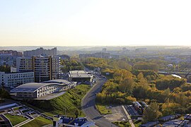
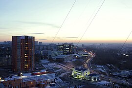
Kemerovo is a city located in the southeast of Western Siberia in Russia, in the northern part of the Kuznetsk coal basin (Kuzbass), about 3,600 km east of Moscow. The administrative center of Kemerovo Oblast, it is an important industrial, transport, economic, scientific, and cultural center of Siberia.
The population of Kemerovo is about 559,000 (2019), the area — 295 sq. km.
The phone code — +7 3842, the postal codes — 650000-650970.
History of Kemerovo
The history of the development of Kemerovo is closely connected with the development of Western Siberia. The oldest settlement on the territory of today’s Kemerovo was the village of Scheglova located on the right bank of the Tom River and first mentioned in 1701.
In 1721, the ore prospector M. Volkov found “combustible stone” (coal) near this village for the first time in Kuzbass. However, at that time this discovery didn’t lead to any practical steps for the development of these coal deposits.
By 1734, not far from Scheglova, along with a number of other villages, the village of Kemerova emerged (later Kemerovo; named after the first settler A. Kemirov). In 1825-1827, the Shcheglovskoye coal deposit was studied by geologists. In the 19th century, there were several villages in the territory of the future city.
In 1907, the Kemerovo mine was founded on the basis of the Shcheglovskoye coal deposit. In 1915, the main shaft of the Kemerovo mine was built. In 1918, the village of Scheglovo was transformed into the county town of Scheglovsk. In 1921, coal production in Kuzbass began to rise. In 1926, the population of the town was about 22,000 people.
More historical facts…
With the development of industrial construction, the town began to grow. In June 1930, a session of the Town Council considered a draft design for the planning of Scheglovsk. The city was designed for 130 thousand residents. When considering the project, the question arose of the name of the city. The residents actively participated in the discussion of this issue.
It was decided that the name of the former village of Shcheglova didn’t have a direct historical connection with the city specialized on the extraction and processing of coal. On March 27, 1932, Shcheglovsk was renamed Kemerovo. Its further development was associated with the rapid development of industrial production. In 1938, the city had more than 100 industrial facilities. In 1939, Shcheglovsk had about 133,000 residents.
In 1941, during the Second World War, a number of plants were evacuated from the western regions of the USSR to Kemerovo. Gunpowder and explosives were produced at local defense enterprises. On January 26, 1943, the Kuzbass Industrial Region received the status of a separate region (oblast). Kemerovo became the administrative center of Kemerovo Oblast.
In 1945, Kemerovo was a miserable sight with numerous dilapidated buildings and undeveloped streets. The city urgently needed a development and improvement plan, which was made over four years from 1947 to 1951. Kemerovo developed according to this plan until 1970. The city continued to grow, absorbing nearby villages. In 1989, the population of Kemerovo was about 520,000 people.
On October 16, 2006, the Kuznetsk Bridge was commissioned in Kemerovo — one of the widest bridges (40.5 meters) in Siberia, which replaced the obsolete Communal Bridge.
In today’s Russia, Kemerovo, as before, is a large industrial center. Income from coal mining occupies a major place in the total income of the city.
Architecture of Kemerovo
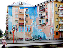
Graffiti on apartment buildings in Kemerovo
Author: Igor Khmaro
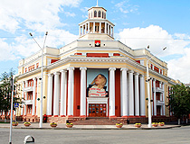
The City Hall of Kemerovo
Author: Igor Khmaro
Kemerovo — Features
The city of Kemerovo is located in the forest-steppe strip of the southern part of Western Siberia, in the northern part of the Kuznetsk coal basin, on both banks of the Tom River at the confluence of the Iskitim River. The right-bank part of the city is connected to the left bank by two automobile and one railway bridges.
The climate of Kemerovo is sharply continental. It is characterized by a long cold winter lasting about 5 months and a short, quite warm summer. The average temperature in January is minus 17 degrees Celsius, in July — plus 19 degrees Celsius.
The City Day is celebrated on June 12 and coincides with the Day of Russia. On the last Sunday of August, Kemerovo celebrates Miner’s Day. The airport of Kemerovo located about 2.5 kilometers south-east of the outskirts of the city offers regular flights to Moscow, St. Petersburg, Novosibirsk, Kazan, Sochi.
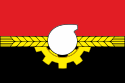
On the coat of arms of Kemerovo you can see the image of a stylized chemical retort and gear parts that symbolize the chemical and engineering industries — the main directions of industrial development of this city. Ears of wheat symbolize the fertility of soil associated with the use of mineral fertilizers produced at the chemical enterprises of Kemerovo.
Kemerovo is one of the largest industrial centers of the region (chemical and coal industries, mechanical engineering, electric power generation). JSC “SDS Azot” is one of the largest manufacturers of nitrogen fertilizers in Russia. The presence of raw materials (coal, refractory clay, limestone, quarry stone, gravel, wood), a convenient industrial site, and railway communication led to the creation of a powerful energy-chemical complex here.
The recreational potential of the city is represented by a pine forest on the right bank of the Tom River, as well as an island and beaches on the Tom River.
In total, there are more than 100 objects of cultural heritage in Kemerovo. These are monuments of architecture and urban planning, monumental art, history and archeology. Kemerovo is in the full sense a city of miners and most of its attractions are somehow connected with the mining industry.
Main Attractions of Kemerovo
“Krasnaya Gorka” — a museum-reserve created on the territory of the former coal mine. The district of Krasnaya Gorka (“red hill”) is an open-air museum. Here, on the steep bank of the Tom River, you can see a unique complex of monuments of mining, historical and cultural heritage. The monuments constitute a single thematic complex associated with the development of the coal industry of Kuzbass. The exposition “Coal Mine” is open in the basement of the museum. Krasnaya Gorka Street, 17.
The Red Hill and the monument “In Memory of the Kuzbass Miners”. One of the most important places in Kemerovo, part of the Krasnaya Gorka Museum-Reserve. The history of Kemerovo began here. This name originates from flashes of fire at the site of the first coal discovered in Kuzbass. It is one of the highest places in the city with the best observation deck of Kemerovo. Also there is an impressive monument dedicated to miners here.
Vesennyaya Street — one of the oldest streets in Kemerovo about 1.5 km long. In the middle of the street there is a boulevard — a popular resting place for locals and visitors of Kemerovo. Here you can see a number of interesting sculptural compositions.
Kemerovo Regional Museum of Fine Arts. The collection of this museum includes more than 5 thousand works of art, most of which are on display in the permanent exhibition. In the halls of the museum visitors can see the paintings of Russian artists created from the late 18th to the beginning of the 21st centuries, works of masters of decorative and applied art, an excellent collection of old icons. Sovetskiy Avenue, 48.
Kemerovo Regional Museum of Local Lore — the oldest museum in the region with a large collection of natural and historical monuments of Kuzbass. This museum has one of the largest paleontological collections in Russia. Sovetskiy Avenue, 55.
The museum “Archeology, Ethnography, and Ecology of Siberia”. Here you can learn about the history and nature of this unique region. There are exhibitions about the flora and fauna of Siberia, Kazakhstan, the Far East, and Central Asia. The archaeological section has collections of artifacts related to the Stone and Bronze Ages, the Scythian and Hunnic periods. Separate halls are devoted to ethnography. Sovetskiy Avenue, 77.
The Coal Museum — the only museum of coal in Russia. The Kemerovo region is one of the largest suppliers of coal in Russia, the variety of coal mined here is recognized globally. Here you can see unique collections of coal, exhibits devoted to mining technologies and the history of the development of the Kuznetsk coal basin. Leningradskiy Street, 10.
Chudes (Miracles) Park — the oldest park in Kemerovo opened more than 80 years ago, a great place for families. Playgrounds with safe swings and carousels for kids, rides of varying degrees of extremeness, sports grounds, the Children’s Railway, a ferris wheel attract a lot of visitors. There are several cafes in the park; in the evenings, artists perform on stages. The pedestrian promenade along the bank of the Tom River begins here. Kirova Street, 4.
“Kuzbass Railway Museum” — a small museum of rare railway equipment. The exposition consists of ten exhibits and is located in the city center near the Pionerskaya station of the Children’s Railway. Pritomskiy Avenue, 2.
Kemerovo also has such cultural institutions as a philharmonic, a drama theater, a puppet theater, a musical theater, and a circus.
|
Kemerovo Кемерово |
|
|---|---|
|
City[1] |
|
View of Kemerovo |
|
|
Flag
Coat of arms |
|
| Anthem: none[2] | |
|
Location of Kemerovo
|
|
|
Kemerovo Location of Kemerovo
Kemerovo Kemerovo (Kemerovo Oblast) |
|
| Coordinates: 55°22′N 86°04′E / 55.367°N 86.067°ECoordinates: 55°22′N 86°04′E / 55.367°N 86.067°E | |
| Country | Russia |
| Federal subject | Kemerovo Oblast[1] |
| Founded | May 9, 1918[3] |
| Government | |
| • Body | City Council of People’s Deputies[4] |
| • Head[4] | Ilya Sereduk[5] |
| Elevation | 140 m (460 ft) |
| Population
(2010 Census)[6] |
|
| • Total | 532,981 |
| • Estimate
(2018)[7] |
558,973 (+4.9%) |
| • Rank | 30th in 2010 |
|
Administrative status |
|
| • Subordinated to | Kemerovo City Under Oblast Jurisdiction[1] |
| • Capital of | Kemerovo Oblast[8], Kemerovsky District[1] |
|
Municipal status |
|
| • Urban okrug | Kemerovsky Urban Okrug[9] |
| • Capital of | Kemerovsky Urban Okrug[9], Kemerovsky Municipal District[9] |
| Time zone | UTC+7 (MSK+4 |
| Postal code(s)[11] |
650000–650004, 650010, 650014, 650016, 650021, 650023–650026, 650029, 650031–650033, 650035, 650036, 650040, 650042–650044, 650051, 650052, 650054–650056, 650060, 650061, 650064–650066, 650068, 650070, 650071, 650700, 650880, 650890, 650899, 650920, 650940–950957, 650960, 650961, 650971–650979, 650991–650993, 650997–650999 |
| Dialing code(s) | +7 3842 |
| OKTMO ID | 32701000001 |
| City Day | June 12[12] |
| Website | www.kemerovo.ru |


Kemerovo (Russian: Ке́мерово, IPA: [ˈkʲemʲɪrəvə]) is an industrial city and the administrative center of Kemerovo Oblast, Russia, located at the confluence of the Iskitimka and Tom Rivers, in the major coal mining region of the Kuznetsk Basin. Population: 557,119 (2021 Census);[13] 532,981 (2010 Census);[6] 484,754 (2002 Census);[14] 520,263 (1989 Census).[15]
The city was known as Shcheglovsk until March 27, 1932.[3]
History[edit]
Kemerovo is an amalgamation of, and successor to, several older Russian settlements. A waypoint named Verkhotomsky ostrog was established nearby in 1657 on a road from Tomsk to Kuznetsk fortress. In 1701, the settlement of Shcheglovsk was founded on the left bank of the Tom; soon it became a village. By 1859, seven villages existed where modern Kemerovo is now: Shcheglovka (or Ust-Iskitimskoye), Kemerovo (named in 1734), Yevseyevo, Krasny Yar, Kur-Iskitim (Pleshki), Davydovo (Ishanovo), and Borovaya. In 1721, coal was discovered in the area. The first coal mines were established in 1907, later a chemical plant was established in 1916. By 1917, the population of Shcheglovo had grown to around 4,000 people.
The area’s further development was boosted by the construction of a railway between Yurga and Kolchugino (now Leninsk-Kuznetsky) with a connection between Topki and Shcheglovo. Shcheglovo was granted town status on May 9, 1918, which is now considered to be the date of Kemerovo’s founding;[3] and was later known as Shcheglovsk. The town became the central location for the Kuzbass Autonomous Industrial Colony which was established there in 1921. 650 workers from 20 countries settled there and set up what became the Kemerovo Coke Chemical Plant. Some of their descendants visited the modern factory in 2011.[16] On May 27, 1932, Shcheglovsk was renamed Kemerovo[3] and became the administrative center of Kemerovo Oblast in 1943. In 2018, 60 people were killed by a fire in a shopping mall.[17] In 2022, at least 20 people were killed by a fire in a nursing home.
Etymology[edit]
The city was named after the village of Kemerovo, named after the surname of the first settlers of the Kemerovs. The ending «ovo» suggests a toponymic transition through a personal name.[18] The village gave its name to the Kemerovo mine that arose under it. In 1925, the city of Scheglovsk was formed from two neighboring villages Kemerovo and Scheglovo, which in 1932 was renamed to Kemerovo after the name of the mine. According to another version, the name is based on the Turkic word kemer — «cliff, coast, cliff».[19][20] The inhabitants of the city are called: Kemerovochanin, Kemerovochanka, Kemerovochane.[21][22]
Administrative and municipal status[edit]
Kemerovo is the administrative center of the oblast[8] and, within the framework of administrative divisions, it also serves as the administrative center of Kemerovsky District, even though it is not a part of it.[1] As an administrative division, it is incorporated separately as Kemerovo City Under Oblast Jurisdiction—an administrative unit with a status equal to that of the districts.[1] As a municipal division, Kemerovo City Under Oblast Jurisdiction is incorporated as Kemerovsky Urban Okrug.[9]
Economy[edit]
The industrialization of Kemerovo was driven and underpinned by coal mining and by the heavy industry based on the availability of coal. It remains an important industrial city, built up during the Soviet period, with important steel, aluminum and machinery based manufacturing plants along with chemical, fertilizer, and other manufacturing industries. Since the disintegration of the Soviet Union, the city’s industries have experienced a severe decline, creating high levels of unemployment. Major companies based in the city include Siberian Business Union.
Transportation[edit]
Public transport[edit]
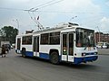
The public transport network of Kemerovo consists of 70 city bus routes (including 6 seasonal), 63 suburban (including 35 seasonal), 53 public taxi routes (including 2 seasonal), 5 tram, and 9 trolleybus routes.[23]
686 transport units enter the streets of the city every day, including:
- 201 buses of city and suburban routes;
- 364 units of route taxis;
- 121 units of electric transport.[24]
The fare in public transport is 20 rubles, in express buses — 21 rubles, in fixed-route taxis — 22 rubles (as of March 24, 2019).[25] Free Wi-Fi was used in all Kemerovo trams to attract passenger traffic.[26]
Air transportation[edit]
The city is served by Kemerovo International Airport that reside 2.5 kilometres to the south-east of the city. It has one runway with artificial turf of class B that length is 3200 meters. The airport is named after the Russian cosmonaut Alexei Leonov, a native of Kuzbass. There are two bus routes to the airport — 101 and 126.
Railway transportation[edit]
Kemerovo is linked to western Russia by a branch of the Trans-Siberian Railway and has the Kemerovo Railway station.
-

NefAZ-5299 bus
-

BTZ-52761 trolleybus
-

KTM-19 tram
-
Kemerovo railroad station


Education[edit]
Six higher education institutions are located in Kemerovo: Kemerovo State University, Kuzbass State Technical University, Kemerovo Institute of Food Industry (University), Kemerovo State Medical Academy, Kemerovo State Institute of Culture, Kemerovo Agricultural Institute and Kuzbass Economy and Justice Institute.
Sports[edit]
The public interest for bandy is widespread in Russia. 26,000 watched the opening game of the 2011–12 Russian Bandy League when local club Kuzbass played against Dynamo Moscow[27] and Kuzbass is among the very best in the Russian Bandy League.[28] The 2007 Bandy World Championship was held in the city.[29] Female bandy only exists in a few places in Russia. Now Kemerovo is about to start it up.[30][31] Moscow already had two multi-use indoor arenas where bandy can be played. Kemerovo got the first one in Russia specifically built for bandy[32] (today also Khabarovsk and Ulyanovsk have it).[33] Kuzbass plays the matches in the league at Khimik Stadium because of the big public interest. That arena has a capacity of 32000.[34] As it also is equipped with artificial ice, Kemerovo has the best infrastructure for developing bandy in Russia.[35]
Since 2013 there has been a «bandy on boots» tournament for national diasporas living in Kuzbass.[36]
Climate[edit]
Kemerovo’s position gives it a humid continental climate (Köppen Dfb) with warm summers and long, severely cold winters. Its average temperatures vary from −17 °C (1 °F) in January to 19 °C (66 °F) in July. It has fairly low precipitation of around 525 mm (20.7 in) annually.
| Climate data for Kemerovo (1991–2020, extremes 1955–present) | |||||||||||||
|---|---|---|---|---|---|---|---|---|---|---|---|---|---|
| Month | Jan | Feb | Mar | Apr | May | Jun | Jul | Aug | Sep | Oct | Nov | Dec | Year |
| Record high °C (°F) | 6.0 (42.8) |
6.8 (44.2) |
14.6 (58.3) |
30.2 (86.4) |
34.4 (93.9) |
35.1 (95.2) |
38.0 (100.4) |
36.3 (97.3) |
33.1 (91.6) |
24.5 (76.1) |
13.8 (56.8) |
5.8 (42.4) |
38.0 (100.4) |
| Average high °C (°F) | −12.7 (9.1) |
−8.7 (16.3) |
−0.4 (31.3) |
9.6 (49.3) |
18.6 (65.5) |
23.9 (75.0) |
25.7 (78.3) |
23.1 (73.6) |
15.9 (60.6) |
7.6 (45.7) |
−3.5 (25.7) |
−10.1 (13.8) |
7.4 (45.3) |
| Daily mean °C (°F) | −17.3 (0.9) |
−14.5 (5.9) |
−6.4 (20.5) |
3.3 (37.9) |
11.2 (52.2) |
17.1 (62.8) |
19.3 (66.7) |
16.4 (61.5) |
9.7 (49.5) |
2.6 (36.7) |
−7.3 (18.9) |
−14.4 (6.1) |
1.6 (34.9) |
| Average low °C (°F) | −21.7 (−7.1) |
−19.4 (−2.9) |
−11.6 (11.1) |
−2.0 (28.4) |
4.6 (40.3) |
10.7 (51.3) |
13.4 (56.1) |
10.9 (51.6) |
4.8 (40.6) |
−1.2 (29.8) |
−10.8 (12.6) |
−18.7 (−1.7) |
−3.4 (25.9) |
| Record low °C (°F) | −47.9 (−54.2) |
−47.1 (−52.8) |
−39.9 (−39.8) |
−32.4 (−26.3) |
−12.6 (9.3) |
−5.7 (21.7) |
0.5 (32.9) |
−1.2 (29.8) |
−9.4 (15.1) |
−27.9 (−18.2) |
−39.5 (−39.1) |
−48.4 (−55.1) |
−48.4 (−55.1) |
| Average precipitation mm (inches) | 29 (1.1) |
22 (0.9) |
21 (0.8) |
25 (1.0) |
42 (1.7) |
65 (2.6) |
78 (3.1) |
63 (2.5) |
47 (1.9) |
44 (1.7) |
46 (1.8) |
43 (1.7) |
525 (20.7) |
| Average rainy days | 0.3 | 0.3 | 2 | 9 | 15 | 15 | 14 | 15 | 16 | 12 | 4 | 0 | 103 |
| Average snowy days | 22 | 19 | 16 | 10 | 2 | 0.1 | 0 | 0 | 1 | 11 | 20 | 24 | 125 |
| Average relative humidity (%) | 79 | 78 | 75 | 67 | 58 | 67 | 73 | 76 | 75 | 77 | 80 | 80 | 74 |
| Mean monthly sunshine hours | 60 | 99 | 165 | 207 | 255 | 282 | 299 | 240 | 161 | 96 | 58 | 43 | 1,965 |
| Source 1: Pogoda.ru.net[37] | |||||||||||||
| Source 2: Climatebase (sun 1955–2012)[38] |
City symbols[edit]
Coat of arms[edit]

The heraldic description of the coat of arms of the city of Kemerovo is the following: in the crossed scarlet and black field, there is a narrow golden belt in the form of two diverging heads of grain ears, behind them there is a golden cogwheel that goes down; there is a silver retort in the middle, its neck tilted to the right.
The figures of the coat of arms of the city of Kemerovo symbolize the historically established main directions of the industrial development of the city:
- retort — chemical industry;
- cogwheel — mechanical engineering;
- ears of corn — the fertility of the land associated with the use of mineral fertilizers produced at the chemical enterprises of the city.
The colors used in the coat of arms symbolize:
- scarlet (red) — work, courage, energy, and strength;
- black color — wisdom, as well as the main wealth of the region, the center of which is the city of Kemerovo, — coal;
- silver (white) — pure thoughts, reliability, and kindness;
- gold (yellow) — wealth and prosperity.[39]
Flag[edit]
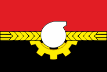
The flag of the city of Kemerovo is based on the city’s coat of arms and repeats its symbolism. It is a rectangular double-sided panel with a width to length ratio of 2:3. It displays figures from the coat of arms of the city of Kemerovo. The colors used are red, black, yellow, and white. [39]
Emblem[edit]

The emblem of Kemerovo displays the monument of Mikhailo Volkov, the discoverer of coal in the area. The sculpture of Mikhailo Volkov displayed on the pedestal fragment styled like a rock. Behind the monument, there is a black triangle that symbolizes a spoil tip. The inscription of the city’s name («Кемерово» in Russian) resides on the diagonal from the left bottom side of the triangle. In the black part of the triangle, the year of the foundation of the city is displayed — «1918».[39]
Numismatics[edit]
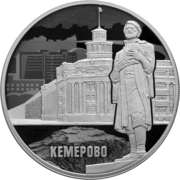
Silver coin «Centenary of the Foundation of Kemerovo» (2018)
In 2018 Bank of Russia issued into circulation the commemorative silver coin in denomination of 3 rubles «Centenary of the Foundation of Kemerovo» which displays the statue of Mikhailo Volkov.[40]
Notable people[edit]
- Yuri Arbachakov, boxer
- Maria Barakova, mezzo-soprano; winner of Glinka and Tchaikovsky classical music competitions
- Andreas Beck, association football player
- Diana Borisova, rhythmic gymnast
- Julia Chernogorova, Great British Bake Off contestant
- Marina Domashenko, opera singer
- Vyacheslav Ivanenko, retired race walker
- Alexei Leonov, cosmonaut; honorable citizen of Kemerovo
- Alexandra Merkulova, retired rhythmic gymnast
- Slava Mogutin, artist
- Wladimir Sukhatsky, TV producer
- Aman Tuleyev, governor of Kemerovo Oblast
- Nikolai Knyzhov, NHL player for the San Jose Sharks
- Artem Vakhitov, kickboxer
- Yuliya Karimova, Russian-born Azerbaijani volleyball player
Twin towns – sister cities[edit]
Kemerovo is twinned with:[41]
 Salgótarján, Hungary
Gallery[edit]
-

-
-
-
-
-

-
Victory Park (Парк Победы) or Zhukov’s Park (Парк имени Жукова) in Kemerovo]


![Victory Park (Парк Победы) or Zhukov's Park (Парк имени Жукова) in Kemerovo]](https://upload.wikimedia.org/wikipedia/commons/thumb/2/24/Kemerovo_park-pobedy-dandelions.JPG/240px-Kemerovo_park-pobedy-dandelions.JPG)
See also[edit]
- Immaculate Heart of Mary Church, Kemerovo
References[edit]
Notes[edit]
- ^ a b c d e f Law #215-OZ
- ^ According to Article 6 of the Charter of Kemerovo, the symbols of Kemerovo include a flag, a coat of arms, and an emblem, but not an anthem.
- ^ a b c d Charter of Kemerovo, Article 1
- ^ a b Charter of Kemerovo, Article 10
- ^ Official website of Kemerovo. Valery Konstantinovich Yermakov Archived September 23, 2017, at the Wayback Machine, Head of the City (in Russian)
- ^ a b Russian Federal State Statistics Service (2011). Всероссийская перепись населения 2010 года. Том 1 [2010 All-Russian Population Census, vol. 1]. Всероссийская перепись населения 2010 года [2010 All-Russia Population Census] (in Russian). Federal State Statistics Service.
- ^ «26. Численность постоянного населения Российской Федерации по муниципальным образованиям на 1 января 2018 года». Federal State Statistics Service. Retrieved January 23, 2019.
- ^ a b Charter of Kemerovo Oblast, Article 2
- ^ a b c d Law #104-OZ
- ^ «Об исчислении времени». Официальный интернет-портал правовой информации (in Russian). June 3, 2011. Retrieved January 19, 2019.
- ^ Почта России. Информационно-вычислительный центр ОАСУ РПО. (Russian Post). Поиск объектов почтовой связи (Postal Objects Search) (in Russian)
- ^ Charter of Kemerovo, Article 6
- ^ Russian Federal State Statistics Service. Всероссийская перепись населения 2020 года. Том 1 [2020 All-Russian Population Census, vol. 1] (XLS) (in Russian). Federal State Statistics Service.
- ^ Russian Federal State Statistics Service (May 21, 2004). Численность населения России, субъектов Российской Федерации в составе федеральных округов, районов, городских поселений, сельских населённых пунктов – районных центров и сельских населённых пунктов с населением 3 тысячи и более человек [Population of Russia, Its Federal Districts, Federal Subjects, Districts, Urban Localities, Rural Localities—Administrative Centers, and Rural Localities with Population of Over 3,000] (XLS). Всероссийская перепись населения 2002 года [All-Russia Population Census of 2002] (in Russian).
- ^ Всесоюзная перепись населения 1989 г. Численность наличного населения союзных и автономных республик, автономных областей и округов, краёв, областей, районов, городских поселений и сёл-райцентров [All Union Population Census of 1989: Present Population of Union and Autonomous Republics, Autonomous Oblasts and Okrugs, Krais, Oblasts, Districts, Urban Settlements, and Villages Serving as District Administrative Centers]. Всесоюзная перепись населения 1989 года [All-Union Population Census of 1989] (in Russian). Институт демографии Национального исследовательского университета: Высшая школа экономики [Institute of Demography at the National Research University: Higher School of Economics]. 1989 – via Demoscope Weekly.
- ^ «Descendants of Dutch colonists visit OAO Koks». www.koksgroup.ru. KOKS group. Archived from the original on December 20, 2016. Retrieved December 16, 2016.
- ^ «Russia fire: Children killed in Kemerovo shopping centre blaze». BBC News. March 25, 2018. Retrieved March 25, 2018.
- ^ Мурзаев Э. М. Словарь народных географических терминов. М.: 1984 — С. 248
- ^ Мурзаев Э. М., Мурзаева В. Э. Словарь местных географических терминов. — М.: Госиздат географической литературы, 1959. — С. 108.
- ^ Никонов В. А. Краткий топонимический словарь. — М.: Мысль, 1966. — С. 186.
- ^ Городецкая И. Л., Левашов Е. А. Русские названия жителей: Словарь-справочник. — М.: Русские словари, Астрель, АСТ, 2003. — С. 138.
- ^ Алабугина Ю. В.с Новый орфографический словарь русского языка с приложением. — М.: АСТ, 2016. — С. 411.
- ^ САРДАКОВА, Екатерина (May 25, 2011). «На кемеровских остановках появилось новое расписание общественного транспорта». kem.kp.ru.
- ^ «Торжественное мероприятие, посвященное дню работника автомобильного и городского пассажирского транспорта и подведение итогов конкурса на звание «Лучший по профессии» | УЕЗТУ».
- ^ «В Кемерове изменилась стоимость проезда по безналичному расчету». April 3, 2019.
- ^ «Â êåìåðîâñêèõ òðàìâàÿõ ïîÿâèëñÿ áåñïëàòíûé Wi-Fi». Interfax.ru.
- ^ «Google Translate». translate.google.com. Retrieved March 25, 2018.
- ^ KuzbassBandyClub (November 29, 2009). «Кузбасс — Боровичи.avi». Archived from the original on December 11, 2021 – via YouTube.
- ^ OrangeMaxim (August 1, 2011). «ЧМ по хоккею с мячом. Кемерово 2007. Все голы финала.mpg». Archived from the original on December 11, 2021. Retrieved March 25, 2018 – via YouTube.
- ^ «Отправная точка | BANDYNET.RU». Archived from the original on November 29, 2009. Retrieved December 4, 2009.
- ^ «Yahoo! Babel Fish — Text Translation and Web Page Translation». Archived from the original on October 10, 2007. Retrieved December 4, 2009.
- ^ «Информация о стадионе «КЛД стадиона «Химик», Кемерово — Реестр — Федерация хоккея с мячом России». rusbandy.ru.
- ^ «Google Translate». translate.google.com. Retrieved March 25, 2018.
- ^ «Google Translate». translate.google.com. Retrieved March 25, 2018.
- ^ «Google Translate». translate.google.co.uk. Retrieved March 25, 2018.
- ^ «Google Translate». translate.google.com. Retrieved March 25, 2018.
- ^ «Weather and Climate — Climate of Kemerovo» (in Russian). Погода и климат. Retrieved November 4, 2021.
- ^ «Kemerovo, Kemerovo, Russia #29645». Climatebase. Retrieved November 12, 2021.
- ^ a b c «Администрация города Кемерово». kemerovo.ru.
- ^ «Centenary of the Foundation of Kemerovo | Bank of Russia». www.cbr.ru.
- ^ «Кемерово». planetatalantov.ru (in Russian). Planeta Talantov. Retrieved February 4, 2020.
Sources[edit]
- Законодательное Собрание Кемеровской области. №10-ОЗ 5 июня 1997 г. «Устав Кемеровской области», в ред. Закона №65-ОЗ от 8 июля 2015 г. «О внесении поправки в Устав Кемеровской области». Вступил в силу по истечении 10 дней после официального опубликования. Опубликован: «Кузбасс», №102, 11 июня 1997 г. (Legislative Assembly of Kemerovo Oblast. #10-OZ June 5, 1997 Charter of Kemerovo Oblast, as amended by the Law #65-OZ of July 8, 2015 On Amending the Charter of Kemerovo Oblast. Effective as of the day which is 10 days after the official publication.).
- Кемеровский городской Совет народных депутатов. Постановление №253 от 24 июня 2005 г. «Устав города Кемерово», в ред. Решения №437 от 27 ноября 2015 г. «О внесении изменений в Устав города Кемерово». Вступил в силу 1 января 2006 г. Опубликован: «Кемерово», №28, приложение «Официально», 8 июля 2005 г. (Kemerovo City Council of People’s Deputies. Resolution #253 of June 24, 2005 Charter of the City of Kemerovo, as amended by the Decision #437 of November 27, 2015 On Amending the Charter of the City of Kemerovo. Effective as of January 1, 2006.).
- Совет народных депутатов Кемеровской области. Закон №215-ОЗ от 27 декабря 2007 г. «Об административно-территориальном устройстве Кемеровской области», в ред. Закона №131-ОЗ от 22 декабря 2014 г. «О внесении изменений в Закон Кемеровской области «О статусе и границах муниципальных образований» и Закон Кемеровской области «Об административно-территориальном устройстве Кемеровской области»». Вступил в силу в день, следующий за днём официального опубликования. Опубликован: «Кузбасс», №243, 28 декабря 2007 г. (Council of People’s Deputies of Kemerovo Oblast. Law #215-OZ of December 27, 2007 On the Administrative-Territorial Structure of Kemerovo Oblast, as amended by the Law #131-OZ of December 22, 2014 On Amending the Law of Kemerovo Oblast «On the Status and the Borders of the Municipal Formations» and the Law of Kemerovo Oblast «On the Administrative-Territorial Structure of Kemerovo Oblast». Effective as of the day following the official publication date.).
- Совет народных депутатов Кемеровской области. Закон №104-ОЗ от 17 декабря 2004 г. «О статусе и границах муниципальных образований», в ред. Закона №123-ОЗ от 22 декабря 2015 г. «О внесении изменений в Закон Кемеровской области «О статусе и границах муниципальных образований»». Вступил в силу со дня официального опубликования. Опубликован: «Кузбасс», №242, 24 декабря 2004 г. (Council of People’s Deputies of Chelyabinsk Oblast. Law #104-OZ of December 17, 2004 On the Status and the Borders of the Municipal Formations, as amended by the Law #123-OZ of December 22, 2015 On Amending the Law of Kemerovo Oblast «On the Status and the Borders of the Municipal Formations». Effective as of the official publication date.).
External links[edit]
![]() Media related to Kemerovo at Wikimedia Commons
Media related to Kemerovo at Wikimedia Commons
- Official website of Kemerovo (in Russian)
- Kemerovo Business Directory (in Russian)
The capital of Kuzbass – the smoky city of Kemerovo – can hardly be called a tourist magnet. Here people do not rest, and what a sin to hide, not especially and enjoy life: not for idle pleasures, the first settlers of Kemerovo laid a village in Western Siberia, on the banks of the Tom and Bolshaya Kamyshnya rivers. The city of labor valor, the terrible environmental situation and the eternal fight against crime, Kemerovo welcomes hard workers, shift workers, business travelers and strange passionaries who are all looking for the Russian soul, and for some reason not in fashionable restaurants in Moscow.
Kemerovo is a strange city. Here live strong and tired people who are accustomed to be content with little. As a result, it turns out, according to the Financial University under the Government of the Russian Federation, 72nd place out of 75 possible in terms of housing and communal services and well-being. According to the citizens themselves, 7-10 years ago it was much better. Now coal and rolled metal are not needed by anyone, so the once prosperous city-mine is slowly decrepit and drunk.
Nevertheless, if fate threw in Kemerovo, there is something to see: the city has many interesting museums and hiking trails. If time allows, you can explore the surroundings, because being in Western Siberia and not seeing Shanda or Sheregesh is an unfortunate omission.
This is interesting: The famous Soviet astronomer Tamara Smirnova in 1970 discovered a small, less than 30 kilometers in diameter, main-belt asteroid (between Mars and Jupiter) and named it after Kemerovo.
- 1 Wonder Park
- 2 Museum of Fine Arts
- 3 Museum of Archaeology, Ethnography and Ecology of Siberia
- 4 Kemerovo Regional Museum of Local Lore
- 5 Coal Museum
- 6 Kemerovo Children’s Railway
- 7 Museum-polygon of railway equipment
- 8 Botanical Garden
- 9 Pritomskaya embankment
- 10 Farm “Farm Frenzy”
- 11 Red Mountain
- 12 Museum-Reserve “Krasnaya Gorka”
- 13 Lake Red
- 14 Kedrovsky coal mine
- 15 Ostrich Ranch
- 16 Museum-Reserve “Tomsk Pisanitsa”
- 17 Sheregesh Ski Resort
- 18 Shanda Village
- 19 Kuznetsk Fortress
- 20 Shor National Park
- 21 Museum-Reserve “Trekhrechye”
- 22 Gulag Museum
- 23 Attractions Kemerovo on map
Wonder Park
- On map
- GPS: 55.364660,86.074781
In every decent city there is a certain city garden (aka Gorky Park) with attractions, walking alleys, a couple of fountains, a summer theater and thickets of juniper. They built these mountains. gardens for a long time, back in the days of all-Soviet care for the leisure of workers (specifically in Kemerovo park was opened in 1926). And in this sense, Kemerovo is no different from Kharkov, Chernigov, Shymkent or Gomel.
Since then, nothing radically new has been invented. And no, they came up with it: in 2002, the City Garden, familiar to the ear of an ordinary Kemerovo resident, became the Park of Miracles. And on the old (but freshly painted) white entrance arch there were new letters, and next to it – painted lobo-shakers from the cartoon “Two from the casket”. As outdated and meaningless as the rest of the Park of Wonders stuffing in times of ramming digitalization.
In the Park of Miracles there are:
- 30 attractions;
- sports grounds;
- slot machines;
- shooting gallery.
Children’s groups perform on the summer stage, sometimes a guest ensemble plays. The park is open for walks from 07:00 to 22:00. Attractions work on the weather (in summer from 10.00 to 19.30).
Address: Kirov, 4
Site: parkchudes.info
Museum of Fine Arts
- On map
- GPS: 55.356309,86.083166
200 meters from the Park of Miracles is one of the most authoritative Kemerovo museums – the former art gallery, the current Museum of Fine Art. This unusual art museum is located in a 3-storey building, built in the pre-war years in the then popular style of triumph-eclectic (Stalin’s Empire).
The Museum of Fine Art, as a very young (opened in 1969), is allowed to depart from the canons. It is sure to surprise connoisseurs – first of all, the absence of erring “classics” and traditional reproductions for the province. The museum’s collection has more than 6 thousand exhibits and represents Russian visual art from the end of the XIX to the present day. Conventionally, the collection is divided into directly fine art (including modern icons), as well as folk crafts (decorative and applied direction).
The museum is open daily, except Monday, from 10.00 to 19.00 (Sunday from 11.00).
Site: kuzbassizo.ru
Address: Kemerovo, pr-t. Sovetsky d. 48
Museum of Archaeology, Ethnography and Ecology of Siberia
- On map
- GPS: 55.351047,86.095590
The young city is young museums: the Kemerovo Historical Museum was founded by employees of the specialized departments – archeology and zoology at KSU. What began simply as cathedral expositions – to show yourself and please students, in 1980 turned into a serious museum with more than 300 thousand exhibits. He has his own library, archive, laboratories, workshops (including the current place of taxidermist), training center.
The exposition of the museum is divided into two parts:
- Archaeology and ethnography, which describes the development of the region from the stone age to the Middle Ages. The pride of the exhibitions is the exact copies of Altai and Tuvan petroglyphs.
- Nature and ecology, which tells about the unique living resources of the region.
The museum conducts professional excursions. Due to the low popularity of scientific exhibitions among the population, the schedule of the museum should be clarified in advance.
Site: museum.kemsu.ru/main.html
Address: Kemerovo, pr-t. Sovetsky d. 77
Kemerovo Regional Museum of Local Lore
- On map
- GPS: 55.356138,86.080203
Within walking distance from the historical is the largest and most caressed by the authorities museum – local lore. If there is little time or no effort, then its one will be enough to make a complete picture of the city and the region.
The Kuzbass State Museum of Local Lore was founded in 1929 in Shcheglovsk and is now located in the heart of Kemerovo, in a complex of three buildings. The funds gathered generations of researchers and volunteers who were not indifferent to the history of their native land. A significant part of the exposition is gifts (from individuals, public funds, other museums; gifts to A. G. Tuleev are also stored here)
Departments of the museum:
- military history;
- history of the native land;
- nature;
- Research.
The highlight of the collection is paleontological finds, there are more than a thousand of them and this is a lot even by the standards of the capital’s museums. Employees are justifiably proud of the work that is carried out according to the classification and description of fossils. For example, thanks to the Kemerovo Museum, the world knows about Siberian psittacosaurs – unique dinosaurs that were found in 130 million. years ago on the territory of Kuzbass.
The museum is open daily from Tuesday to Sunday from 10:00 to 19:00. Monday is a day off.
Site: http://www.kuzbasskray.ru/
Address: Kemerovo, pr-t. Sovetsky d. 51
Coal Museum
- On map
- GPS: 55.361471,86.163586
There should be a Coal Museum in the coal capital – this is obvious. Another strange thing is that the first and so far the only thematic museum in Russia (the second name: the Laboratory of the History of the Coal Industry) was opened in Kemerovo on the basis of a branch of the Russian Academy of Sciences already in 1999. Before that, apparently, coal was taken for granted.
Now the collection of the Laboratory includes nine lines, which together give a complete picture of the geology of Kuzbass, the understanding of coal formation and the diversity of coals. The exposition of the museum is highly specialized in nature and will be more interesting to geologists or chemists than to ordinary tourists.
Site: http://www.coal.sbras.ru/icc/coal-museum/
Address: Kemerovo, pr-t. Leningradsky d. 10
Kemerovo Children’s Railway
- On map
- GPS: 55.351736,86.107477
In Kemerovo, they love rails – maybe it is not for nothing that the city has not yet abandoned trams? But in general, it is difficult to overestimate the importance of railway transport for heavy industry and coal mining. A unique project – the Kemerovo Children’s Railway – is aimed precisely at explaining this importance to the younger generation, impressing and attracting work on the already adult railway.
In the training center, secondary school students can listen to lectures on the topics:
- automation, telemechanics, acs;
- wagon, locomotive, track facilities;
- organization of train traffic.
Kemerovo Railway was invented and launched not so long ago – in 2008. It was a project of the local authorities and Russian Railways, which became a tourist center for residents of the region.
Facts about CJD:
- 3.8 km long route from Pionerskaya station to Krasnoye Lake;
- two railway stations;
- two trains of three cars;
- each car with 38 seats.
The technical equipment of the tracks will give odds to the “real” Russian Railways. Tickets can be bought at the ticket office of the station. The schedule depends on the time of year.
In the summer of 2021, Kemerovo Railway opened its 14th season. According to official statistics, for all the time it carried 20 thousand passengers.
Site: https://dzd42.ru/
Address: Pritomsky Prospekt
Museum-polygon of railway equipment
- On map
- GPS: 55.351391,86.105459
At the training center of the KJD there is a small open-air museum of rare railway equipment (geographically – near the Pionerskaya station, where the management of the Kuzbass branch of the West Siberian Railway is located).
Exhibits – equipment of the XX century: diesel locomotives, steam locomotives, cars for different purposes, drezin, tanks. On the territory you can take photos and videos.
In 2021, the Museum temporarily did not work due to the reconstruction of the embankment.
Address: Kemerovo, pr-t. Pritomsky d. 2
Botanical Garden
- On map
- GPS: 55.365449,86.190609
Kuzbass Botanical Garden is young and proud. It was organized in 1991 on the basis of the Institute of Coal, and in 2004 the Institute of Human Ecology grew on its basis. Now the botanical garden has an established scientific team and there are three laboratories:
- introduction of plants;
- intensive botany;
- biomonitoring and reclamation.
In addition, the botanical garden is just a beautiful place: the greenhouse is divided into two zones – the humid tropics and subtropics. On the adjacent territory there is a photo zone and a place for walking. The administration plans a café and an entertainment area.
Excursions are available by appointment only.
Site: http://kuzbs.ru/
Address: Kemerovo, Leningradsky Ave., 10
Pritomskaya embankment
- On map
- GPS: 55.358905,86.088425
The best place in the city for walking is almost entirely pedestrian Pritomskaya embankment with a length of about one and a half kilometers. It starts at the Park of Miracles and continues to the Youth Square. On weekends along the embankment you can find at least a few weddings, on weekdays it is crowded with walking Kemerovo residents.
Along the entire length of the street is decorated with interesting sculptural compositions. Among them there is a monument to a stray dog, a grandmother who reads a book to her granddaughter, a smile and the Tom River.
Address: Kemerovo, Pritomskaya embankment str.
Farm “Farm Frenzy”
- On map
- GPS: 55.341039,86.130365
A small petting zoo in the central part of Kemerovo is what you need to show the child animals. Many, many loves, warmth and very soft fur coats: the popularity of “Farm Frenzy” has long bypassed boring museums and stupid parks. Children are always children, it is important for them to see, touch and feed a familiar animal. Food can be bought on the spot. Cup – 50 rubles (price for October 2021).
Working hours daily from 10 to 20 hours (on weekends pandemonium). Children under five years of age pass with their accompanying persons on one ticket.
Site: https://vk.com/zoo_veselayaferma
Address: Kemerovo, Komsomol park named after Vera Voloshina
Extended route
To get pleasure from Kemerovo, the standard route through the center is not enough. All the most interesting things in Kemerovo are not in Kemerovo: the city is too edified and standardized the nature of the region, but has not yet had time to grow its own face – a hundred years, this is only a hundred years, not even a toddle age for a settlement of this level.
Red Mountain
- On map
- GPS: 55.374046,86.078483
The highest point of Kemerovo – Red Mountain (formerly it was called Gorela) is located on the right bank of the Tom. They say that it can be taken as a point of reference: coal began from here, and, therefore, the city itself – in 1721, Tomsk resident Mikhail Volkov at the foot of the mountain discovered layers coming to the surface. However, it began to develop only in the middle of the XIX century.
Red Mountain must be climbed for three reasons:
- The monument “In Memory of the Miners of Kuzbass” by Ernst Neizvestny (installed in 2003) is an eerie monument in its grandeur, a stunning work of the famous sculptor. Dominates the landscape, attracts the eye, emphasizes that every ton of coal is still worth a life.
- Views: to the left – to the city, to the right – to the infernal industrial zone with a coke torch.
- The first tunnel (1907), which overlooks the shore of the Tomi, is now laid with bricks.
Also there originates the historical village of Krasnaya Gorka and you can go down to the Museum of Coal Mining.
Address: Kemerovo, Krasnaya Gora
Museum-Reserve “Krasnaya Gorka”
- On map
- GPS: 55.375477,86.071907
The working settlement at the foot of the Red Mountain in the middle of the industrial zone is an open-air museum that will give odds to any other expositions due to its historical honesty. He shows clearly, without embellishment and artistic beauty: yes, everything was exactly the same and in many ways remained the same. Coal was delivered first from the tunnel on horseback, and then by coke by cable car through the Tom, the first pier was pathetic and wooden, the workers lived in barracks (they are called “sausage houses” here). From the Cabinet of His Imperial Majesty and Kopikuz to AIK and St. Barbara: in the first half of the XX century, Russia finally grew Kuzbass. But behind this industrial miracle are hundreds of thousands of human destinies.
Objects that can be viewed:
- pier;
- remnants of rope supports;
- Office House;
- working settlement – barracks-“sausages”, bath, school.
Only the museum building itself, the former house of the mine manager, has been restored. The rest of the buildings are in a neglected and dull state, among them monuments and memorial plaques stand out with pathetic poles.
The museum is open daily from 10.00 to 17.30, in winter the schedule may vary depending on the weather.
Site: https://redhill-kemerovo.ru/
Address: Kemerovo, Krasnaya Gorka str., 17
Lake Red
- On map
- GPS: 55.365548,86.153219
A local attraction, interesting only to the Kemerovo residents themselves and longing summer business travelers – the local fresh lake Red, which self-formed on the site of a quarry for the extraction of sand. It is said that it is red not out of shame for the dirt or not ennobled beaches, but because of the crayfish. Well, crayfish are so crayfish.
The lake is connected to Tomyu, but much warmer. Kemerovo residents love Red so much that they are not afraid to swim in it – this is once, and fantasized a whole layer of mythology – this is two. As expected, everything is told about the lake. There is also about radiation, and about sewage, and about drowned people, and corruption of local officials. Tourists who dare to approach the beaches of Red (there are two of them and they are both wild) agree to believe in anything. Although it is convenient to get to it, public transport goes almost to the shore.
Address: Leningradsky Skaya 5, 1
Kedrovsky coal mine
- On map
- GPS: 55.520621,86.094954
The Kedrovsky coal mine (part of Kuzbassrazrezugol Management Company) is one of the main deposits in the Central part of Kuzbass, located 25 kilometers from Kemerovo. Coal here is mined in an open way and it looks truly epic.
To get to Kedrovsky, you need to take advantage of a special excursion offer: kur is part of the branded regional route “Kuzbass. Fire in the heart”, approved by Rosturizm in 2020.
Route program:
- visiting the museum;
- inspection of mining equipment;
- tasting of coal ice cream;
- professional examination on equipment for screening the health of miners.
Coal quarries with working equipment look impressive. But an independent inspection is impossible: the incision is a regime object.
Site: https://www.kru.ru/ru/about/us/structure/
Address: Kemerovo region, Kedrovka, Sovetskaya str., 5
Ostrich Ranch
- On map
- GPS: 55.373025,86.252105
A small farm almost immediately outside the city limits of Kemerovo, of course, will appeal to adults who have not yet had time to see ostrich farms and will definitely impress children. First, many animals here can be stroked, taken in their arms, squeezed. Secondly, for the middle child enough and first.
The main specialization of the ranch is black African ostriches, but there are many other animals: ponies, goats, deer, pigs, rabbits and even the donkey Tessie. The farm is clean (as far as possible), cozy and comfortable.
To get from Kemerovo will have your own vehicles on the Yelykaevskaya highway: Zhuravlevo is not far away, only 10-15 minutes. On the territory there is a parking lot, a place for a snack and quite a nice café. In summer, horseback riding and quad biking is organized.
The ranch receives visitors on weekends and holidays from 10.00 to 17.00, on weekdays – by appointment. Pet food can be bought at the entrance.
Site: https://www.instagram.com/straus_2016/?hl=ru
Address: Zhuravlevo village, SNT Solnechnaya Polyana 1
Museum-Reserve “Tomsk Pisanitsa”
- On map
- GPS: 55.668832,85.623621
50 km from the city on the banks of the Tom river on an area of about 140 hectares there is a unique reserve dedicated to Siberian petroglyphs – rock art of the Late Bronze And Early Iron period. About 300 drawings form one of the first petroglyphic complexes discovered in Northern Eurasia: the first mention of the work of ancient people is attributed to the expeditions of the time of Peter I.
On the territory of the reserve there are more than a dozen permanent exhibitions, in which archeology, paleontology, ethnography and post-Soviet superstitions are intricately mixed. Nevertheless, to see firsthand rock paintings, reconstruction of Neolithic dwellings or the original house of Shortz will be interesting to any person.
Now the territory of the reserve is landscaped, routes have been developed here, tourist trails and civilized parking lots have been organized. Here you can stay overnight in a tent, and it will be completely safe. You can get to Pisanitsa directly from Kemerovo with an organized excursion, a regular bus to Yashkino or by private car.
https://tomskayapisanitsa.ru/
Sheregesh Ski Resort
- On map
- GPS: 52.953232,87.955933
400 kilometers from Kemerovo (you need to go through Novokuznetsk) in the area with the fabulous name of Mountain Shoria at the foot of Mount Zelenaya is one of the best Siberian ski resorts Sheregesh – the goal of many thousands of tourists from all over Russia.
The resort was opened to the general public in 1981, after the Spartakiad. Since then, its popularity has only grown – mainly due to the unique natural conditions (the temperature does not be lower than -10), chic snow cover (exclusively natural!), magical air, an excellent selection of trails and lifts. Sheregesh is devoid of the refined pathos of Krasnaya Polyana, while it is a fairly civilized resort, where there is a place for both pros and beginners.
The chip of Sheregesh is a freeride route, and because of the viscosity of snow and the combination of temperature and humidity, avalanches or landslides practically do not happen.
The season lasts from November to May inclusive. One track with artificial turf, so it is used even in the summer.
Site: http://www.sheregesh.su/
Shanda Village
- On map
- GPS: 54.310733,86.066989
118 kilometers from Kemerovo in the direction of Novokuznetsk in the Guryevsky district is a tiny village – one of the few settlements of the endangered people of Teleuts. Only a couple of thousand people in the Kemerovo region – all that remains of the indigenous people of Kuzbass … Which we don’t actually know anything about.
The village is not too fun, but a very informative place: teleuts hold various national celebrations (winter Kolodo, Tabyr in spring and Payram in the very gray summer), are always happy to feed tourists with unusual dishes, sing songs (in the House of Culture – the most powerful ensembles and even a small choir), show customs and traditional crafts.
Near the village there is a cult place for teleuts – Mount Shaanthu, Ringing. They say that in a small gorge on this mountain, the energy of heaven and earth connect, so the ringing is heard. After the war, a monument to the mother who did not wait for her son was erected there.
Kuznetsk Fortress
- On map
- GPS: 53.774305,87.182748
The main attraction of the glorious city of Novokuznetsk – a fortress built in samos at the beginning of the XIX century by order of Paul I for the purpose of defense against Chinese raids – did not smell gunpowder, and the Chinese evil also did not see. Nevertheless, it is proudly considered an example of fortifications, although in its walls from the middle of the same XIX century there is a prison, then a museum.
Now the museum is a well-preserved architectural complex on an area of about 20 hectares. In the funds of the museum – archaeological, ethnographic, printed exhibits. You can see everything you need daily from 9.30 to 17.30, weekends from 10.00 to 17.00. Excursions must be booked in advance.
Site: http://kuzn-krepost.ru/
Address: Novokuznetsk, proezd Kremostnoy 1
Shor National Park
- On map
- GPS: 52.773013,87.925128
In the south of the Kemerovo region there is a stunning natural diamond – the national park of federal significance Shorsky. The park is a mountain taiga (dark coniferous species) and is located on a complex mountainous terrain, completely cut by valleys and streams.
Attractions of the park:
- Saga Falls on the left tributary of the Mrassu;
- caves Azasskaya, Kizasskaya, Osinaya, Grandiose, Nadezhda, Oktyabrskaya;
- Rock Royal Gates;
- stone arch Drinking Elephant;
- the remains and the Tazgol Museum.
In the park there are tourist routes (from 150 to 15 km), hiking, cycling and horse riding trails, rafting and descents into the caves are available.
Ecotrails:
- The path of green remains from the taimet stream to the top of Pazyn Mountain (1 km).
- Black taiga (length a little less than 5 km).
- Under the canopy of cedar (length 800 meters).
Not far from the resort of Sheregesh with Mount Mustag. For the comfort of tourists, there are three cordons in different places of the park.
Site: https://shorskynp.ru/
Address: 652990, Kemerovo region, Tashtagol, Sadovaya str. 8
Museum-Reserve “Trekhrechye”
- On map
- GPS: 52.823680,88.444938
On the territory of Mountain Shoria there are many museums, but “Trekhrechye” should be highlighted separately: located in the ancient Teleut village of Ust-Kabyrza, it keeps the memory of the dramatic history of these places. The reserve is located at the confluence of three waterways – Mrassu, Pyzass, Kabyrza, and therefore is called trekhrechye, by the name of that district.
This is an important place for indigenous peoples: from time immemorial, traders, researchers, immigrants flocked here … And a little later, after the conquest of Siberia by the Russians – convicts, eviction, special settlers.
The museum has two expositions:
- ethnographic “Trade and Economic Barn”, dedicated to the life of indigenous people and settlers over the past hundred years, including the USSR (this is how the building is dated);
- memorial “Gulag”, which tells about the survival of hundreds of thousands of people sent to the development of Kuzbass starting with the dispossessed in the 20s and ending with the classic “forest” of the 60s.
To visit the museum, you need to leave a request on the site.
Site: https://kobyrsu-museum.ru/
Address: Kemerovo region, Tashtagol district, pos. Ust-Kabyrza, Arbachakova str., 17 a
Gulag Museum
- On map
- GPS: 55.342997,86.087934
It is difficult to overestimate the role of prisoners and special settlers of the Gulag in the formation and development of Kuzbass. According to minimum estimates, we are talking about hundreds of thousands of people for the period from the 20s to the mid-1990s.
In the mid-30s in Kuzbass there were dozens of camps of Siblag nkvd USSR, people in which were engaged in agriculture, quarries and logging. During and after the war, the composition of political prisoners was replenished with Soviet Germans, former prisoners of war of the Red Army, collaborators, defectors and all those who only allowed to send the imagination of Soviet leaders. For example, it is known that in 1949 the number of prisoners exceeded 105 thousand people. Many of them had nowhere to go after their liberation, so they remained in Western Siberia.
A small departmental museum in Kemerovo is dedicated to the stories of these people. Here are stored their documents, personal belongings, letters, as well as estimates and plans of the camps, declassified materials on the “enemies of the people”, information about the leaders and guards.
Excursions are carried out by prior arrangement. They will be especially interesting for history students.
Address: 650000, Kemerovo region, Kemerovo, Lenin Ave., 53-a, GUFSIN of Russia in Kemerovo region
Kemerovo and its surroundings are not just an industrial giant, accustomed to overcome and lead, but a living city with a rich history, surrounded by the beauty and strength of Western Siberia. Here you can find interesting places, the main thing is not to pupate in the post-Soviet cold, which flooded the streets and parks of the city itself, but literally go beyond the framework and visit the sights of the countryside.
Attractions Kemerovo on map

![]()
- Текст
- Веб-страница
![]()
Kemerovo region is situated in the south of Western Siberia. It is one of the most important industrial center of Russia. In the north the region borders on Tomsk region, in the south — on Altai territory, in the east — on Krasnoyarsk territory, in the west — on Novosibirsk region.
Availability of major coal deposits has determined the second name of the region — Kuzbass (Kuznets Basin).
Kuzbass has a well-developed power-engineering, machine-building and metal- working industries. It is rich in different mineral resources such as coal, iron, zinc and others. The main mineral is coal.
One of the leading industries of Kuzbass is chemical. Most of the chemical plants are located in Zavodskiy district in Kemerovo. They are Azot, Karbolit and Koksohim. They produce mineral fertilizers, plastics, metallurgical coke, chemical powders, resins etc.
Kemerovo is thaw administrative, industrial, cultural and educational centre of Kuzbass. It was founded in 1918. Its population is more than 500 thousand people. Our city is rather young. Kemerovo is situated on the river Tom. The centre of the city is on the left bank.
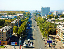
There are many places of interest in Kemerovo: the Monument of Glory, the Alley of Heroes, the Drama theatre with the beautiful singing fountain. Puppet theatre, Musical Comedy theatre, Pushkin Square and the most beautiful places of Kemerovo. Kemerovo Circus was built in 1973. It houses 2 thousand people. The streets in Kemerovo are broad and straight. The street traffic is rather heavy. The longest avenues are Sovetsky, Lenin and Oktyabrsky.
Kemerovo is a city of students. There are two Universities, some Institutes, the Medical Academy and many colleges, professional vocational and technical schools in Kemerovo. School-leavers from Like any other city Kemerovo has its own problems. But I hope that in future it will become more beautiful and modern.
0/5000
Результаты (русский) 1: [копия]
Скопировано!
Кемеровская область расположена на юге Западной Сибири. Это один из самых важных промышленных центра России. На севере граничит с Томской области, на юге — на Алтайского края, на Востоке — Красноярский край, на западе — с Новосибирской области.Наличие крупных угольных месторождений определил имя второго региона — Кузбасс (кузнец бассейна).Кузбасс имеет хорошо развитые отрасли промышленности-энергетика, машиностроение и металлообработка. Он богат различных минеральных ресурсов, таких как уголь, железо, цинк и др. Основным минералом является уголь.Одна из ведущих отраслей промышленности Кузбасса химические. Большинство химических предприятий расположены в Заводский район в Кемерово. Они являются азот, Карболит и Koksohim. Они производят, минеральные удобрения, пластмассы, металлургический кокс, химических порошков, смолы и т.д.Кемерово является административным, промышленным, культурным и образовательным центром оттепель Кузбасса. Он был основан в 1918 году. Его население составляет более чем 500 тысяч человек. Наш город является довольно молодым. Кемерово расположен на реке Томь. Центр города находится на левом берегу.Есть много мест интереса в Кемерово: памятник славы, Аллея героев, драматический театр с красивый Поющий фонтан. Кукольный театр, театр музыкальной комедии, Пушкинская площадь и самых красивых мест в Кемерово. Кемерово цирк был построен в 1973 году. К услугам гостей 2 тысячи человек. Улицы в Кемерово, широкий и прямой. Уличное движение является довольно тяжелым. Советский, Ленинского и Октябрьского длинных проспектов.Кемерово — город студентов. Есть двух университетов, некоторые институты, медицинской академии и многие колледжи, профессиональные профессионально-технической школы в Кемерово. Выпускники школ от как любой другой город Кемерово имеет свои собственные проблемы. Но я надеюсь, что в будущем он станет более красивым и современным.
переводится, пожалуйста, подождите..
Результаты (русский) 2:[копия]
Скопировано!
Кемеровская область расположена на юге Западной Сибири. Это один из наиболее важных промышленных центров России. На севере область граничит с Томской областью, на юге — с Алтайского края, на востоке — с Красноярским краем, на западе -. На Новосибирской обл
Наличие крупных месторождений угля определяется второе название области — Кузбасс ( Кузнец бассейна).
Кузбасс имеет хорошо развитую энергетика, машиностроение и металлообработка промышленности. Он богат минеральными ресурсами различных, таких как уголь, железо, цинк и другие. Основным минералом является уголь.
Один из ведущих отраслей промышленности Кузбасса химического. Большинство химических заводов расположены в районе Заводского в Кемерово. Они Азот, Карболит и Koksohim. Они производят минеральные удобрения, пластмассы, кокс металлургический, химический порошок, смолы и т.д.
Кемеровской оттепель административный, промышленный, культурный и образовательный центр Кузбасса. Он был основан в 1918 году Его население составляет более 500 тысяч человек. Наш город достаточно молодой. Кемерово расположен на реке Томь. Центр города находится на левом берегу.
Есть много интересных мест в Кемерово: Монумент Славы, Аллея Героев, драматический театр с прекрасной поющим фонтаном. Кукольный театр, Театр музыкальной комедии, на Пушкинской площади и самые красивые места Кемерово. Кемерово Цирк был построен в 1973 году домов 2 тысяч человек. Улицы в Кемерово широкие и прямые. Улица трафика довольно тяжелый. Самые длинные проспекты Советский, Октябрьский и Ленин.
Кемерово является городом студентов. Есть два университеты, институты, некоторые медицинской академии и многих колледжах, профессионально профессионально-технических училищах в Кемерово. Абитуриенты из Как и любой другой город Кемерово имеет свои собственные проблемы. Но я надеюсь, что в будущем он станет более красивым и современным.
переводится, пожалуйста, подождите..
Результаты (русский) 3:[копия]
Скопировано!
кемеровская область расположена в юго — западной сибири.это одна из наиболее крупным промышленным центром россии.на севере граничит с томской областью, в южной — в алтайском крае, в восточном — красноярский край, на западе — с новосибирской.
наличие крупных угольных месторождений определил второе название региона — кузбасс (кузнец бассейн).
кузбасс имеет хорошо развитую энергетики, машиностроения и металл — рабочие предприятий.она богата различными минеральных ресурсов, таких, как уголь, железо, цинк и другие.основные минеральных является уголь.
одной из ведущих отраслей промышленности кузбасса — химического вещества.большая часть химического предприятия расположены в zavodskiy район в кемерово.они являются «азот», karbolit и коксохим.они производят минеральных удобрений, пластмасс, металлургического кокса, химического порошки, смол и т.д.
кемерово — оттепель административных, промышленный, культурный и образовательный центр кузбасса.он был основан в 1918 году.его население составляет более 500 тыс. человек.наш город — довольно молодой.кемерово находится на реке томь.центр города находится на левом берегу.
есть много мест, где интерес в кемерово: монумента славы, на аллее героев, драматический театр с красивым поющим фонтаном.кукольный театр, театр музыкальной комедии, пушкинской площади и самых красивых мест, кемерово.кемерово цирк был построен в 1973 году.она дома 2 тыс. человек.улицы в кемерово являются широкими и прямо.улицы движения довольно тяжелым.дольше всех направлений — советский, ленина и октябрьского.
кемерово — город студентов.существует два университета, некоторые институты, медицинской академии и многие колледжей, профессиональных профессионально — технических училищ в кемерово.выпускники, как любой другой город кемерово, имеет свои собственные проблемы.но я надеюсь, что в будущем он станет еще более красивым и современным.
упражнение 6
переводится, пожалуйста, подождите..
Другие языки
- English
- Français
- Deutsch
- 中文(简体)
- 中文(繁体)
- 日本語
- 한국어
- Español
- Português
- Русский
- Italiano
- Nederlands
- Ελληνικά
- العربية
- Polski
- Català
- ภาษาไทย
- Svenska
- Dansk
- Suomi
- Indonesia
- Tiếng Việt
- Melayu
- Norsk
- Čeština
- فارسی
Поддержка инструмент перевода: Клингонский (pIqaD), Определить язык, азербайджанский, албанский, амхарский, английский, арабский, армянский, африкаанс, баскский, белорусский, бенгальский, бирманский, болгарский, боснийский, валлийский, венгерский, вьетнамский, гавайский, галисийский, греческий, грузинский, гуджарати, датский, зулу, иврит, игбо, идиш, индонезийский, ирландский, исландский, испанский, итальянский, йоруба, казахский, каннада, каталанский, киргизский, китайский, китайский традиционный, корейский, корсиканский, креольский (Гаити), курманджи, кхмерский, кхоса, лаосский, латинский, латышский, литовский, люксембургский, македонский, малагасийский, малайский, малаялам, мальтийский, маори, маратхи, монгольский, немецкий, непальский, нидерландский, норвежский, ория, панджаби, персидский, польский, португальский, пушту, руанда, румынский, русский, самоанский, себуанский, сербский, сесото, сингальский, синдхи, словацкий, словенский, сомалийский, суахили, суданский, таджикский, тайский, тамильский, татарский, телугу, турецкий, туркменский, узбекский, уйгурский, украинский, урду, филиппинский, финский, французский, фризский, хауса, хинди, хмонг, хорватский, чева, чешский, шведский, шона, шотландский (гэльский), эсперанто, эстонский, яванский, японский, Язык перевода.
- Дверь дома была выкрашена в зеленый цвет
- Наконец-то утро. Как хорошо что не надо
- Я люблю картошку и яйшницу
- врач говорит, что пациент пошел на попра
- ol, soo i have an idea if ure up for a l
- Spidergrams
- но никто не верит ему
- Nemo omne, quod vult, habere potest, sed
- Conjuguez en accordant l’adjectif posses
- o nomen dulce libertatis
- А какая разница? Нету)
- этот чемодан не мой, это их.
- я смотрю телевизор до девяти часов вечер
- А что?
- Law faculty
- этот чемодан не мой, это их.
- photo by my
- умница
- какая твоя любимая еда пицца вкусно
- Frängst
- А у меня есть кот по имени бус
- Frängst
- Спасибо тебе за все!
- Indication