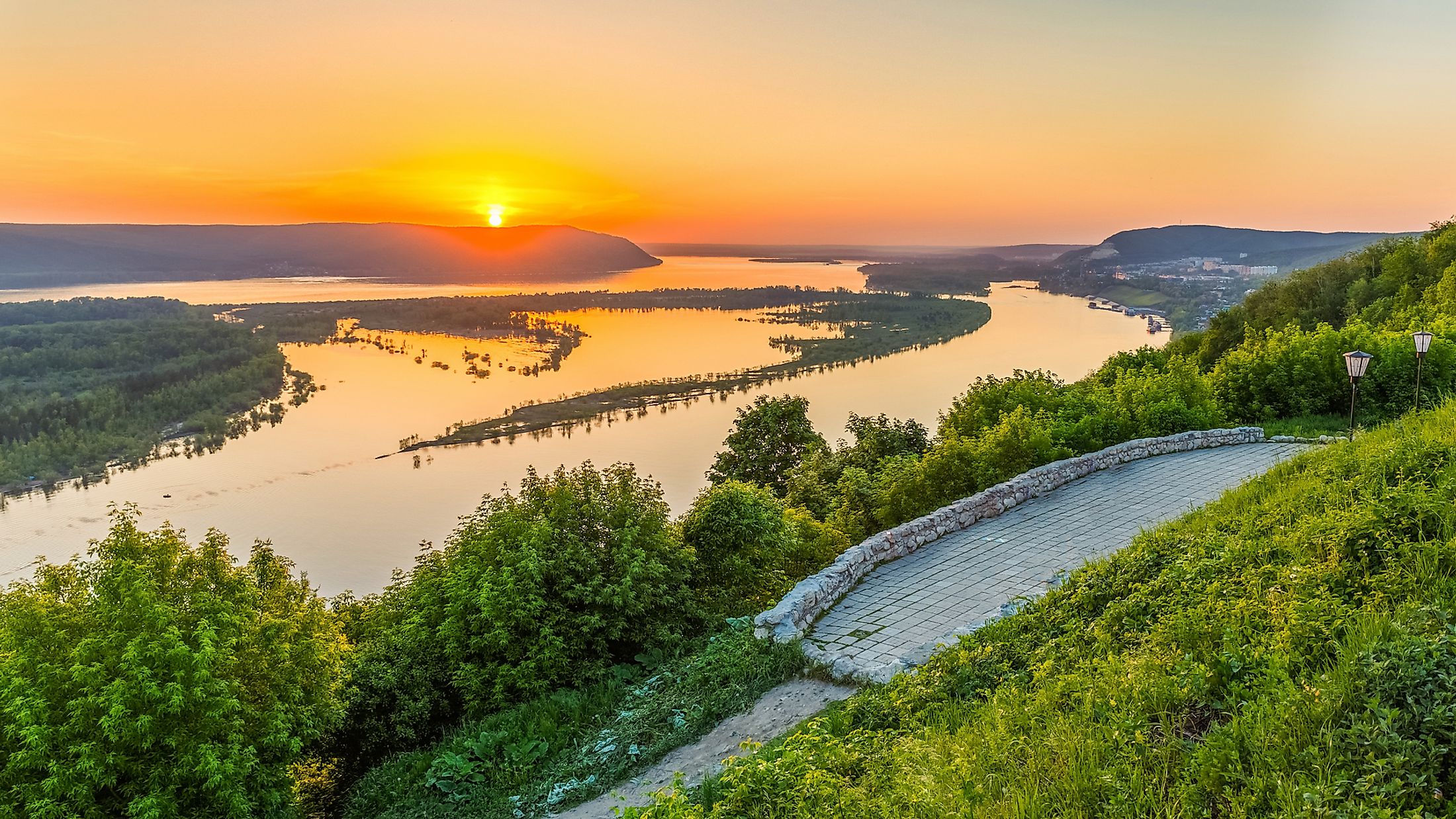
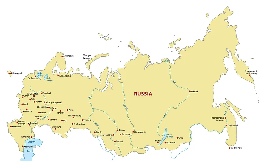
The Volga River is the longest in Europe and western Russia’s principal waterway. It covers much of the Volga region and stretches 3,530 kilometers from its source in the Valdai Hills to the Caspian Sea, the world’s largest inland water body. The Volga River Basin covers almost two-fifth of European Russia and hosts about half of Russia’s population. The river flows entirely through Russia, including four of the countries ten largest cities. Its historic, cultural, and economic importance makes it one of the world’s greatest rivers. Historically, the Volga River was the meeting point of the Eurasian Civilization. It also hosts some of the world’s largest reservoirs and a major source of livelihood to millions of people directly and indirectly.
Contents:
- Description
- River Course
- Hydrology
- Climate
- Aquatic Life
- Economy
- Threats
Description
The Volga River is the world’s 18th longest and Europe’s longest river, covering a distance of about 3,530 kilometers from its source to the mouth in the Caspian Sea. It is the longest river flowing into the Caspian Sea, the world’s largest closed basin. Its source, the Valdai Hills in Tver Oblast, is located at an altitude of 228 meters above sea level, and the Caspian Sea is located at an elevation of 28 meters below sea level.
The Volga River is also Europe’s largest river by drainage basin and discharge. Its drainage basin, located almost entirely in Russia, stretches 1.36 million square kilometers (the world’s 15th largest drainage basin), covering most parts of European Russia and hosting the bulk of the country’s population. The drainage basin is divided into four geographic zones; marshy forest, forest-steppe, steppe, and semi-desert lowlands.
The Volga discharges an average of 8,060 cubic meters of water per second, about 250 cubic kilometers per year. However, the river has a maximum discharge of 48,500 cubic meters of water per second. Volga’s important tributaries include the Oka, Sura, Kama, and Veltuga. The Volga River delta stretches 160 kilometers and comprises about 500 small rivers, making it Europe’s largest estuary.
River Course
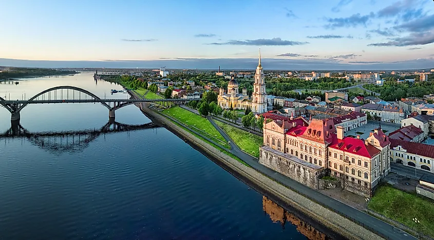
The course of the mighty Volga River is divided into four sections. The section between its source and the confluence with Oka is called the Upper Volga. The Middle Volga begins from the confluence with Oka to confluence with the Kama, while the rest of the length forms the Lower Volga. The Volga River originates from the Valdai Hills as a small stream and only becomes a true river after it being joined by several of its tributaries. From Valdai, the river flows east past a group of small lakes and towns, including Lake Sterzh. It then turns southeast and runs through a trench and past Rzhev before turning northwestwards. Shortly after, Volga receives inflow from Tversta and Vazuza Rivers at Tver. From Tver, it continuous its northwestward flow through Rybinsk Reservoir, which also receives water from other rivers like Sheksna and Mologa.
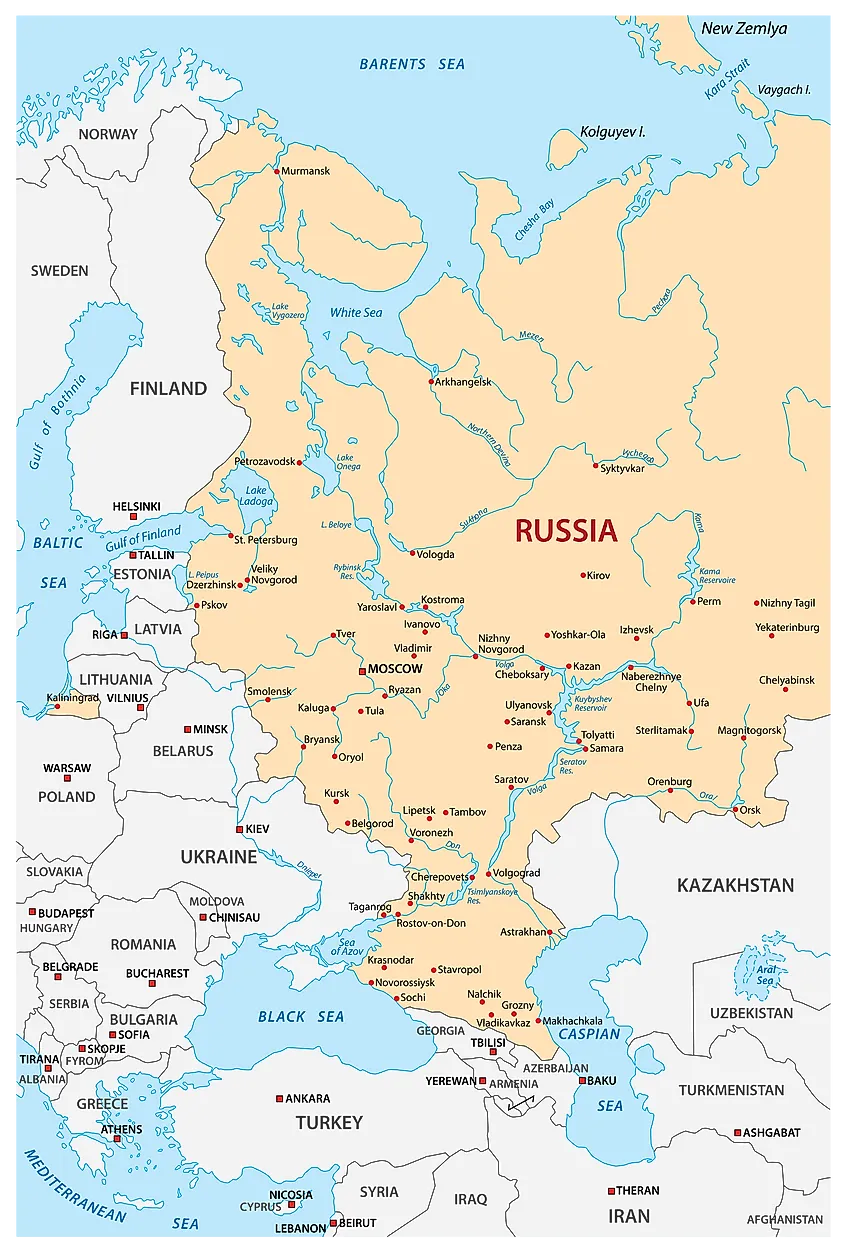
From Rybinsk, Volga changes direction to the southeast and flows to Nizhny Novgorod through a valley between the Galich-Chukhlom Lowland and Danilov Uplands on the north and Uglich Highland on the south. Within this section, Unzha, Oka, and Kostroma Rivers join the Volga. Between Oka and Kazan, the size of the river doubles, receiving inflows from Sviyaga and Sura on the right bank and Vetluga and Kerzhenets on the left bank. From Kazan, Volga flows southwards into Samara Reservoir and is joined by the Kama on the left. Here, the Volga is now a mighty river and changes direction to the southwest and flows along the Volga Hills to Volgograd. At Volgograd, Akhtuba, Volga’s principal distributary, branches on the southeast to the Caspian Sea. The main Volga proceeds to Astrakhan where Buzan, the second distributary, branches into the Volga Delta. Other branches are Old (Staraya) Volga, Kamyzyak, and Bolda.
Hydrology
The Volga River receives much of its water from snow, accounting for up to 60% of the total discharge. Rain accounts for only 10% of the river’s water, with underground sources accounting for the remaining discharge. Before the construction of reservoirs along the river, Volga’s regime was characterized by spring floods and annual fluctuations. The water level ranged from 3 to 15 meters on the Lower Volga, 12 to 14 meters on the Middle Volga, and 7 to 11 meters on the Upper Volga. The river’s average discharge also varies with location, with Tver recording 180 cubic meters per second, 1,100 cubic meters per second at Yaroslavl, and 7,715 cubic meters per second at Samara. The average annual discharge at the river’s mouth is 8,060 cubic meters per second.
Climate
The climate of the Volga River basin exhibits variation along its course from north to south. The northern reaches of the river experience a temperate climate defined by cold, snow-covered winters, and warm, humid summers. Meanwhile, the lower parts of the river basin have hot, dry summers, and cold winters. Precipitation levels gradually drop from north to south.
Aquatic Life
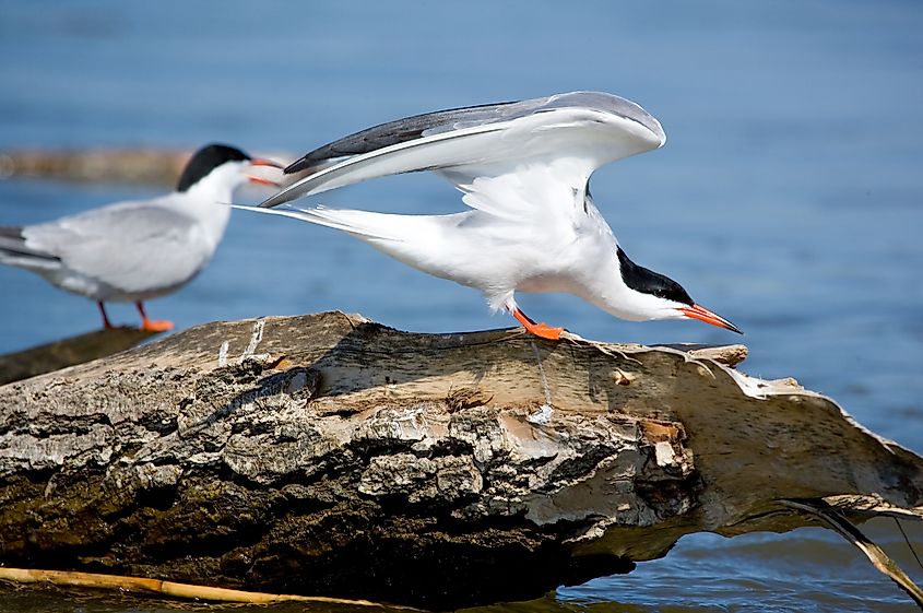
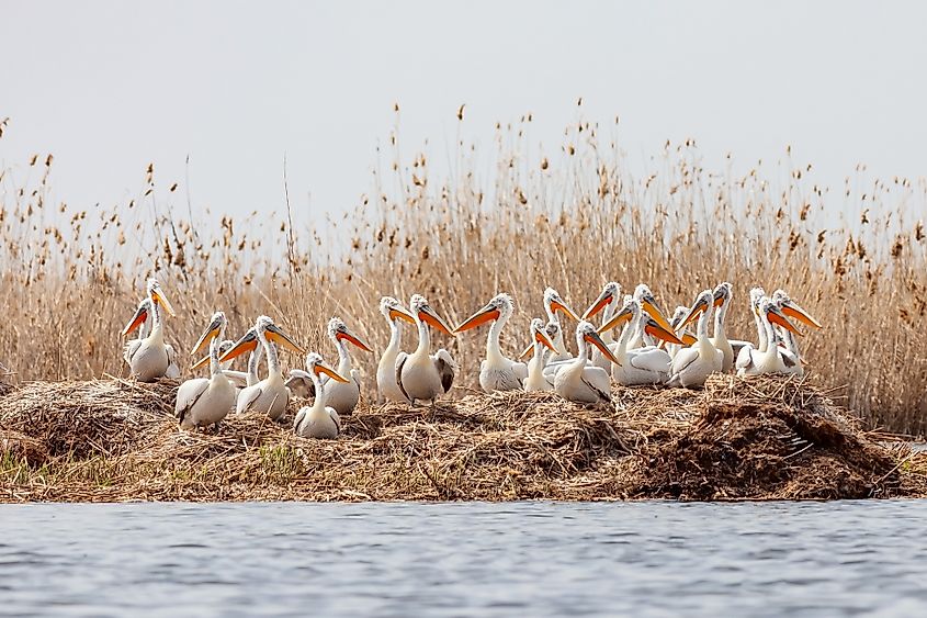
The Volga River Delta at the mouth of the river is a species-rich habitat harboring 430 species of flora, 127 fish species, 260 species of birds, and 850 species of aquatic invertebrates, as well as a large repertoire of insect species. Many migratory birds, such as Dalmatian pelicans, great white egrets, breed in the Volga Delta’s wetlands. Fish species in the river include several kinds of sturgeons, Volga lampreys, whitefish, and herrings.
Economy
The Volga River hosts some of the world’s largest reservoirs and dams, converting the river into a chain of small lakes. The reservoirs include navigation locks and hydropower stations. The uppermost reservoir at Ivankovo covers approximately 326 square kilometers and was completed in 1937. The reservoir Uglich reservoir covers about 250 square kilometers, while the Rybinsk Reservoir stretches 4,532 square kilometers. Other reservoirs are located at Samara, Cheboksary, Volgograd, and Saratov. The Volga has eight hydroelectric power stations along its path, while the Kama, its main tributary, has three power stations.
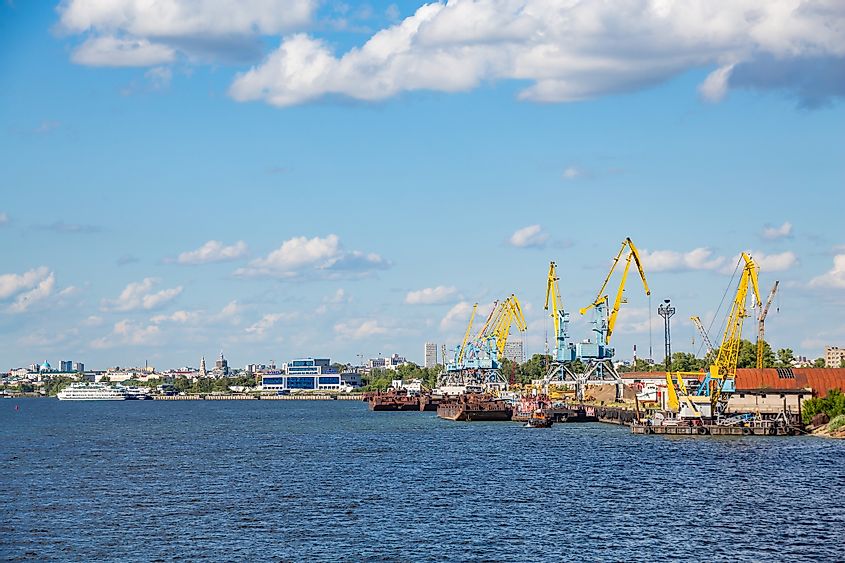
The Volga is navigable for about 3,330 kilometers, with the over 70 navigable tributaries transporting more than half of Russia’s inland freight. Raw and construction material accounts for about four-fifths of the total freights. Other goods transported along the river include foodstuff, petroleum products, salt, and agricultural machinery. The Volga-Baltic Waterway links the Volga River to the Baltic Sea, which joins the White Sea via the White Sea-Baltic Canal. Thus, the Volga River is linked to the major European waterway system.
Threat
Although the Volga River has benefited the Russian economy for ages, the effects of indiscriminate human activity have taken their toll on the ecosystem of the river basin. The large-scale inundation of the river, facilitated by the development of dams and reservoirs along its course, has led to a lowering of the volume of waters reaching the Caspian Sea. This, combined with the high rates of pollution of river waters, has greatly dilapidated the aquatic flora and fauna of the river. Fish species like the beluga sturgeon and whitefish, which reside in the sea but migrate to the upper reaches of the Volga for spawning, are now facing obstructions to their natural migratory routes. Large-scale poaching of fish species of the river has led to the endangering the survival of these fishes. Currently, six species of sturgeons are listed as Critically Endangered, six are Vulnerable, and all but two species are in some way threatened.
«Wolga» redirects here. For the genus of rotifers, see Wolga (rotifer).
| Volga | |
|---|---|

The Volga at Yaroslavl |
|

Map of the Volga drainage basin |
|
| Etymology | Proto-Slavic *vòlga «wetness» |
| Native name | Волга (Russian) |
| Location | |
| Location | Eastern Europe |
| Country | Russian Federation |
| Cities | Tver, Yaroslavl, Nizhny Novgorod, Cheboksary, Kazan, Ulyanovsk, Samara, Saratov, Volgograd, Astrakhan |
| Physical characteristics | |
| Source | |
| • location | Valdai Hills, Tver Oblast |
| • coordinates | 57°15′4.7″N 32°28′5.1″E / 57.251306°N 32.468083°E |
| • elevation | 228[1] m (748 ft) |
| Mouth | Caspian Sea |
|
• location |
Astrakhan Oblast |
|
• coordinates |
45°50′N 47°58′E / 45.833°N 47.967°E[2] |
|
• elevation |
−28[1] m (−92 ft) |
| Length | 3,531 km (2,194 mi)[3] |
| Basin size | 1,360,000 km2 (530,000 sq mi)[3] 1,404,107.6 km2 (542,129.0 sq mi)[4] |
| Discharge | |
| • location | Astrakhan (Basin size: 1,391,271.8 km2 (537,173.0 sq mi) |
| • average | 8,060 m3/s (285,000 cu ft/s)
8,103.078 m3/s (286,157.5 cu ft/s)[5] Volga Delta: 8,110.544 m3/s (286,421.2 cu ft/s)[6] |
| • minimum | 5,000 m3/s (180,000 cu ft/s) |
| • maximum | 48,500 m3/s (1,710,000 cu ft/s) |
| Discharge | |
| • location | Volgograd (Basin size: 1,359,396.8 km2 (524,866.0 sq mi) |
| • average | 8,150 m3/s (288,000 cu ft/s) 8,228.298 m3/s (290,579.6 cu ft/s)[7] |
| • minimum | 5,090 m3/s (180,000 cu ft/s) |
| • maximum | 48,450 m3/s (1,711,000 cu ft/s) |
| Discharge | |
| • location | Samara (Basin size: 1,218,995.3 km2 (470,656.7 sq mi) |
| • average | 7,680 m3/s (271,000 cu ft/s) 7,785.921 m3/s (274,957.2 cu ft/s)[8] |
| Discharge | |
| • location | Nizhny Novgorod (Basin size: 479,637.3 km2 (185,189.0 sq mi) |
| • average | 2,940 m3/s (104,000 cu ft/s)
2,806.467 m3/s (99,109.4 cu ft/s)[9] Yaroslavl (Basin size: 153,657.8 km2 (59,327.6 sq mi): 1,008.277 m3/s (35,607.0 cu ft/s)[10] Rybinsk (Basin size: 150,119.8 km2 (57,961.6 sq mi): 993.253 m3/s (35,076.4 cu ft/s)[11] |
| Discharge | |
| • location | Tver (Basin size: 24,658.6 km2 (9,520.7 sq mi) |
| • average | 176 m3/s (6,200 cu ft/s) 186.157 m3/s (6,574.1 cu ft/s)[12] |
| Basin features | |
| Tributaries | |
| • left | Kama |
| • right | Oka |
The Volga (; Russian: Во́лга) is the longest river in Europe. Situated in Russia, it flows through Central Russia to Southern Russia and into the Caspian Sea. The Volga has a length of 3,531 km (2,194 mi), and a catchment area of 1,360,000 km2 (530,000 sq mi).[3] It is also Europe’s largest river in terms of average discharge at delta – between 8,000 m3/s (280,000 cu ft/s) and 8,500 m3/s (300,000 cu ft/s) – and of drainage basin. It is widely regarded as the national river of Russia. The hypothetical old Russian state, the Rus’ Khaganate, arose along the Volga c. 830 AD.[13] Historically, the river served as an important meeting place of various Eurasian civilizations.[14][15][16]
The river flows in Russia through forests, forest steppes and steppes. Four of the ten largest cities of Russia, including the nation’s capital, Moscow, are located in the Volga’s drainage basin.
Some of the largest reservoirs in the world are located along the Volga River. The river has a symbolic meaning in Russian culture – Russian literature and folklore often refer to it as Волга-матушка Volga-Matushka (Mother Volga).
Etymology[edit]

Cruise ship on the Volga.
The Russian hydronym Volga (Волга) derives from Proto-Slavic *vòlga ‘wetness, moisture’, which is preserved in many Slavic languages, vlaga (влага) ‘moisture’, Bulgarian vlaga (влага) ‘moisture’, Czech vláha ‘dampness’, Serbo-Croatian: vlaga (влага) ‘moisture’, Slovene vlaga ‘moisture’, Polish wilgoć ‘moisture’ and Macedonian vlaga (влага) ‘moisture’, among others.[17]
The Scythian name for the Volga was Rahā,[18] literally meaning ‘wetness’. This is related to the Avestan name for the river; Raŋhā (𐬭𐬀𐬢𐬵𐬁) (derived from Proto-Indo-European *h1res- or *h1ers-, ‘wet’ or ‘moisture’), or ‘mythical stream’[19] (also compare the derivation Sogdian rʾk (𐽀𐼰𐼸) ‘vein, blood vessel’ (from Old Iranian *raha-ka),[20] Persian رگ rag ‘vein’[21] and Vedic Sanskrit rasā́ (रसा) ‘dew, liquid, juice; mythical river’).[22] The Scythian name survives in modern Moksha Rav (Рав).[23][24]
The Greek author Herodotus recorded two more ancient Iranic names of the Volga:
- Oarus (Ancient Greek: Οαρος Oaros; Latin: Oarus), which was derived from Scythian *Varu, meaning ‘broad’. The ancient Greek name of the Dnieper river, Borysthenes (Βορυσθενης Borusthenēs; Latin: Borysthenes), was also connected to this term since its original Scythian form was *Varustāna, meaning ‘having broad space’.[25]
- Araxes (Ancient Greek: Αραξης Araxēs; Latin: Araxes)[26][27]
The Turkic peoples living along the river formerly referred to it as Itil or Atil. In modern Turkic languages, the Volga is known as İdel (Идел) in Tatar, Atăl (Атӑл) in Chuvash, Iźel in Bashkir, Edıl in Kazakh, and İdil in Turkish. The Turkic names go back to the ancient Turkic form “Etil/Ertil”, the origin and meaning of which are not clear. Perhaps this form has a connection with the hydronym Irtesh.[28]
The Turkic peoples associated the Itil’s origin with the Kama.[29] Thus, a left tributary to the Kama was named the Aq Itil ‘White Itil’ which unites with the Kara Itil ‘Black Itil’ at the modern city of Ufa.[citation needed] The name Indyl (Indɨl) is used in the Cherkess language.
In Asia the river was known by its other Turkic name Sarı-su ‘yellow water’, but the Oirats also used their own name, Ijil mörön or ‘adaptation river’. Presently the Mari, another Uralic group, call the river Jul (Юл), meaning ‘way’ in Tatar. Formerly, they called the river Volgydo, a borrowing from Old East Slavic.[citation needed]
Description[edit]

The confluence of the Oka (to the left) and the Volga in Nizhny Novgorod
The Volga is the longest river in Europe, and its catchment area is almost entirely inside Russia, though the longest river in Russia is the Ob–Irtysh river system.[1]
It belongs to the closed basin of the Caspian Sea, being the longest river to flow into a closed basin. Rising in the Valdai Hills 225 meters (738 ft) above sea level northwest of Moscow and about 320 kilometers (200 mi) southeast of Saint Petersburg, the Volga heads east past Lake Sterzh, Tver, Dubna, Rybinsk, Yaroslavl, Nizhny Novgorod, and Kazan. From there it turns south, flows past Ulyanovsk, Tolyatti, Samara, Saratov and Volgograd, and discharges into the Caspian Sea below Astrakhan at 28 meters (92 ft) below sea level.[1] At its most strategic point, it bends toward the Don («the big bend»). Volgograd, formerly Stalingrad, is located there.


The upper Volga in the vicinity of Staritsa, 1912
The Volga has many tributaries, most importantly the rivers Kama, the Oka, the Vetluga, and the Sura. The Volga and its tributaries form the Volga river system, which flows through an area of about 1,350,000 square kilometres (521,238 square miles) in the most heavily populated part of Russia.[1] The Volga Delta has a length of about 160 kilometres (99 miles) and includes as many as 500 channels and smaller rivers. The largest estuary in Europe, it is the only place in Russia where pelicans, flamingos, and lotuses may be found.[citation needed] The Volga freezes for most of its length for three months each year.[1]
The Volga drains most of Western Russia. Its many large reservoirs provide irrigation and hydroelectric power. The Moscow Canal, the Volga–Don Canal, and the Volga–Baltic Waterway form navigable waterways connecting Moscow to the White Sea, the Baltic Sea, the Caspian Sea, the Sea of Azov and the Black Sea. High levels of chemical pollution have adversely affected the river and its habitats.
The fertile river valley provides large quantities of wheat, and also has many mineral riches. A substantial petroleum industry centers on the Volga valley. Other resources include natural gas, salt, and potash. The Volga Delta and the Caspian Sea are fishing grounds. Astrakhan, at the delta, is the center of the caviar industry.
Confluences (downstream to upstream)[edit]

The Starovolzhsky Bridge in Tver

- Akhtuba (near Volzhsky), a distributary
- Bolshoy Irgiz (near Volsk)
- Samara (in Samara)
- Kama (south of Kazan)
- Kazanka (in Kazan)
- Sviyaga (west of Kazan)
- Vetluga (near Kozmodemyansk)
- Sura (in Vasilsursk)
- Kerzhenets (near Lyskovo)
- Oka (in Nizhny Novgorod)
- Uzola (near Balakhna)
- Unzha (near Yuryevets)
- Kostroma (in Kostroma)
- Kotorosl (in Yaroslavl)
- Sheksna (in Cherepovets)
- Mologa (near Vesyegonsk)
- Kashinka (near Kalyazin)
- Nerl (near Kalyazin)
- Medveditsa (near Kimry)
- Dubna (in Dubna)
- Shosha (near Konakovo)
- Tvertsa (in Tver)
- Vazuza (in Zubtsov)
- Selizharovka (in Selizharovo)
Reservoirs (downstream to upstream)[edit]
A number of large hydroelectric reservoirs were constructed on the Volga during the Soviet era. They are:
- Volgograd Reservoir
- Saratov Reservoir
- Kuybyshev Reservoir – the largest in Europe by surface
- Cheboksary Reservoir
- Gorky Reservoir
- Rybinsk Reservoir
- Uglich Reservoir
- Ivankovo Reservoir
Biggest cities on the shores of the Volga[edit]
- Kazan
- Nizhny Novgorod
- Samara
- Volgograd
- Saratov
- Tolyatti
- Yaroslavl
- Astrakhan
- Ulyanovsk
- Cheboksary
- Tver
Human history[edit]

The Volga–Oka region has been occupied for at least 9,000 years and supported a bone and antler industry for producing bone arrowheads, spearheads, lanceheads, daggers, hunters knives, and awls. The makers also used local quartz and imported flints.[30]
During classical antiquity, the Volga formed the boundary between the territories of the Cimmerians in the Caucasian Steppe and the Scythians in the Caspian Steppe.[26] After the Scythians migrated to the west and displaced the Cimmerians, the Volga became the boundary between the territories of the Scythians in the Pontic and Caspian Steppes and the Massagetae in the Caspian and Transcaspian steppes.[27]
Between the 6th and the 8th centuries, the Alans settled in the Middle Volga region and in the steppes of Russia’s southern region in the Pontic–Caspian steppe.[31]
The area around the Volga was inhabited by the Slavic tribes of Vyatichs and Buzhans, by Finnic, Scandinavian, Baltic, Hunnic and Turkic peoples (Tatars, Kipchaks) in the first millennium AD, replacing the Scythians.[32] Furthermore, the river played a vital role in the commerce of the Byzantine people. The ancient scholar Ptolemy of Alexandria mentions the lower Volga in his Geography (Book 5, Chapter 8, 2nd Map of Asia). He calls it the Rha, which was the Scythian name for the river. Ptolemy believed the Don and the Volga shared the same upper branch, which flowed from the Hyperborean Mountains. Between 2nd and 5th centuries Baltic people were very widespread in today’s European Russia. Baltic people were widespread from Sozh River till today’s Moscow and covered much of today’s Central Russia and intermingled with the East Slavs.[33] The Russian ethnicity in Western Russia and around the Volga river evolved to a very large extent, next to other tribes, out of the East Slavic tribe of the Buzhans and Vyatichis. The Vyatichis were originally concentrated on the Oka river.[34] Furthermore, several localities in Russia are connected to the Slavic Buzhan tribe, like for example Sredniy Buzhan[35] in the Orenburg Oblast, Buzan and the Buzan river in the Astrakhan Oblast.[36][35] Buzhan (Persian: بوژان, romanized: Būzhān; also known as Būzān) is also a village in Nishapur, Iran. In late 8th century the Russian state Russkiy Kaganate is recorded in different Northern and Oriental sources. The Volga was one of the main rivers of the Rus’ Khaganates culture.[37]
Subsequently, the river basin played an important role in the movements of peoples from Asia to Europe. A powerful polity of Volga Bulgaria once flourished where the Kama joins the Volga, while Khazaria controlled the lower stretches of the river. Such Volga cities as Atil, Saqsin, or Sarai were among the largest in the medieval world. The river served as an important trade route connecting Scandinavia, Finnic areas with the various Slavic tribes and Turkic, Germanic, Finnic and other people in Old Rus’, and Volga Bulgaria with Khazaria, Persia and the Arab world.

Khazars were replaced by Kipchaks, Kimeks and Mongols, who founded the Golden Horde in the lower reaches of the Volga. Later their empire divided into the Khanate of Kazan and Khanate of Astrakhan, both of which were conquered by the Russians in the course of the 16th century Russo-Kazan Wars. The Russian people’s deep feeling for the Volga echoes in national culture and literature, starting from the 12th century Lay of Igor’s Campaign.[38] The Volga Boatman’s Song is one of many songs devoted to the national river of Russia.
Construction of Soviet Union-era dams often involved enforced resettlement of huge numbers of people, as well as destruction of their historical heritage. For instance, the town of Mologa was flooded for the purpose of constructing the Rybinsk Reservoir (then the largest artificial lake in the world). The construction of the Uglich Reservoir caused the flooding of several monasteries with buildings dating from the 15th and 16th centuries. In such cases the ecological and cultural damage often outbalanced any economic advantage.[39]
20th-century conflicts[edit]

During the Russian Civil War, both sides fielded warships on the Volga. In 1918, the Red Volga Flotilla participated in driving the Whites eastward, from the Middle Volga at Kazan to the Kama and eventually to Ufa on the Belaya.[40]
During World War II, the city on the big bend of the Volga, currently known as Volgograd, witnessed the Battle of Stalingrad, possibly the bloodiest battle in human history, in which the Soviet Union and the German forces were deadlocked in a stalemate battle for access to the river. The Volga was (and still is) a vital transport route between central Russia and the Caspian Sea, which provides access to the oil fields of the Absheron Peninsula. Hitler planned to use access to the oil fields of Azerbaijan to fuel future German conquests. Apart from that, whoever held both sides of the river could move forces across the river, to defeat the enemy’s fortifications beyond the river.[41] By taking the river, Hitler’s Germany would have been able to move supplies, guns, and men into the northern part of Russia. At the same time, Germany could permanently deny this transport route by the Soviet Union, hampering its access to oil and to supplies via the Persian Corridor.
For this reason, many amphibious military assaults were brought about in an attempt to remove the other side from the banks of the river. In these battles, the Soviet Union was the main offensive side, while the German troops used a more defensive stance, though much of the fighting was close quarters combat, with no clear offensive or defensive side.
Ethnic groups[edit]

Many different ethnicities lived on the Volga river. Numerous were the Eastern Slavic Vyatchi tribes which took a decisive role in the development of modern Russians.[42][43] Among the first recorded people along the upper Volga were also the Finnic Mari (Мари) and Merya (Мäрӹ) people. Where the Volga flows through the steppes the area was also inhabited by the Iranian people of the Sarmatians from 200 BC.[44][45] Since ancient times, even before Rus’ states developed, the Volga river was an important trade route where not only Slavic, Turkic and Finnic peoples lived, but also Arab world of the Middle East met the Varangian people of the Nordic countries through trading.[46][47] In the 8th and 9th centuries colonization also began from Kievan Rus’. Slavs from Kievan Rus’ brought Christianity to the upper Volga, and a portion of non-Slavic local people adopted Christianity and gradually became East Slavs. The remainder of the Mari people migrated to the east far inland. In the course of several centuries the Slavs assimilated the indigenous Finnic populations, such as the Merya and Meshchera peoples. The surviving peoples of Volga Finnic ethnicity include the Maris, Erzyas and Mokshas of the middle Volga. Also Khazar and Bulgar peoples inhabited the upper, middle and lower of the Volga River basin.[48]
Apart from the Huns, the earliest Turkic tribes arrived in the 7th century and assimilated some Finno-Ugric and Indo-European population on the middle and lower Volga. The Turkic Christian Chuvash and Muslim Volga Tatars are descendants of the population of medieval Volga Bulgaria. Another Turkic group, the Nogais, formerly inhabited the lower Volga steppes.
The Volga region is home to a German minority group, the Volga Germans. Catherine the Great had issued a manifesto in 1763 inviting all foreigners to come and populate the region, offering them numerous incentives to do so.[49] This was partly to develop the region but also to provide a buffer zone between the Russians and the Mongols to the east.[citation needed] Because of conditions in German territories, Germans responded in the largest numbers. Under the Soviet Union a slice of the region was turned into the Volga German Autonomous Soviet Socialist Republic.
Flora and fauna[edit]
|
This section is empty. You can help by adding to it. (October 2022) |
Navigation[edit]


In some locations, the Volga has a rocky west bank.
The Volga, widened for navigation purposes with construction of huge dams during the years of Joseph Stalin’s industrialization, is of great importance to inland shipping and transport in Russia: all the dams in the river have been equipped with large (double) ship locks, so that vessels of considerable dimensions can travel from the Caspian Sea almost to the upstream end of the river.
Connections with the river Don and the Black Sea are possible through the Volga–Don Canal. Connections with the lakes of the North (Lake Ladoga, Lake Onega), Saint Petersburg and the Baltic Sea are possible through the Volga–Baltic Waterway; and commerce with Moscow has been realised by the Moscow Canal connecting the Volga and the Moskva River.
This infrastructure has been designed for vessels of a relatively large scale (lock dimensions of 290 by 30 metres (951 ft × 98 ft) on the Volga, slightly smaller on some of the other rivers and canals) and it spans many thousands of kilometers. A number of formerly state-run, now mostly privatized, companies operate passenger and cargo vessels on the river; Volgotanker, with over 200 petroleum tankers, is one of them.
In the later Soviet era, up to the modern times, grain and oil have been among the largest cargo exports transported on the Volga.
[50] Until recently access to the Russian waterways was granted to foreign vessels on a very limited scale. The increasing contacts between the European Union and Russia have led to new policies with regard to the access to the Russian inland waterways. It is expected that vessels of other nations will be allowed on Russian rivers soon.[51]
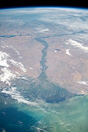
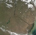
Satellite imagery[edit]
-

Terra/MODIS, 2002-05-17.
-

Terra/MODIS, 2001-10-10.

Cultural significance[edit]
Literature[edit]
- Without a Dowry, The Storm – dramas by the Russian playwright Aleksandr Ostrovsky
- In the Forests, On the Hills – novels by Pavel Melnikov
- Yegor Bulychov and Others, Dostigayev and Others – plays by Maxim Gorky
- «Distance After Distance» – poem by Aleksandr Tvardovsky
- «On the Volga» – a poem by Nikolay Nekrasov
- «Volga and Vazuza» – a poem by Samuil Marshak
- The Precipice – a novel by Ivan Goncharov
- Volga Se Ganga — a novel by Hindi language writer Rahul Sankrityayan
Cinema[edit]
- Volga-Volga (1938) – a Soviet film comedy directed by Grigori Aleksandrov
- Ekaterina Voronina (1957) – Soviet drama film directed by Isidor Annensky
- The Bridge Is Built (1965) – a Soviet film about the construction of a road bridge across the Volga in Saratov by Oleg Efremov and Gavriil Egiazarov
- A Cruel Romance (1984) – romantic drama directed by Eldar Ryazanov
- Election Day (2007) – Russian comedy film directed by Oleg Fomin
Music[edit]
- The Song of the Volga Boatmen
Video games[edit]
- Metro Exodus – Volga is one of main levels of the game
See also[edit]
- Caspian Depression
- List of rivers of Russia
References[edit]
- ^ a b c d e f Scheffel, Richard L.; Wernet, Susan J., eds. (1980). Natural Wonders of the World. United States of America: Reader’s Digest Association, Inc. p. 406. ISBN 0-89577-087-3.
- ^ Volga at GEOnet Names Server
- ^ a b c «Река Волга» Archived 2016-03-05 at the Wayback Machine, Russian State Water Registry
- ^ «Rivers Network». 2020.
- ^ «Rivers Network». 2020.
- ^ «Rivers Network». 2020.
- ^ «Rivers Network». 2020.
- ^ «Rivers Network». 2020.
- ^ «Rivers Network». 2020.
- ^ «Rivers Network». 2020.
- ^ «Rivers Network». 2020.
- ^ «Rivers Network». 2020.
- ^ Gannholm, Tore. «Birka, Varangian Emporium».
- ^ Luttwak, Edward N. (2011). Grand Strategy of the Byzantine Empire. Belknap Harvard. p. 52. ISBN 978-0674062078. OCLC 733913679.
- ^ Walker, Joel (2007). «Iran and Its Neighbors in Late Antiquity: Art of the Sasanian Empire (224–642 C.E.)». American Journal of Archaeology. 1 11 (4): 797. doi:10.3764/aja.111.4.795. ISSN 0002-9114. S2CID 192943660.
- ^ McNeese, Tim (2005). The Volga river. Philadelphia: Chelsea House Publishers. pp. 14–16. ISBN 0791082474. OCLC 56535045.
- ^ See Max Vasmer’s dictionary under «Волга«.
- ^ Brunner, C. J. (1986). «ARANG». Encyclopædia Iranica. Retrieved 13 August 2022.
Middle Persian Arang/Arag renders Avestan Raŋhā, which is cognate with the Scythian name Rhâ (*Rahā) transmitted by Ptolemy
- ^ J.P. Mallory & D.Q. Adams, Encyclopedia of Indo-European Culture, s.v. «dew» (London: Fitzroy Dearborn, 1997), 158-9.
- ^ Michiel de Vaan, Etymological Dictionary of Latin and the Other Italian Languages, s.v. «rōs, rōris» (Leiden: Brill, 2008), 526-7.
- ^ Nourai, Ali. 2013. An Etymological Dictionary of Persian, English and Other Indo-European Languages. Index of Words in Different Languages, vol. 1, p. 130.
- ^ Lebedynsky, Iaroslav. Les Sarmates : Amazones et lanciers cuirassés entre Oural et Danube. Paris: Editions Errance, 2002.
- ^ Hartley, Janet M. (2021). The Volga: A History. Yale University Press. p. 2. ISBN 978-0-300-24564-6.
- ^ Herrala, Eva; Feoktistov, Aleksandr (1998). Mokšalais-Suomalainen sanakirja. Turku: University of Turku. p. 54. ISBN 951-29-1244-9.
- ^ Harmatta, János (1999). «Herodotus, Historian of the Cimmerians and the Scythians». In Reverdin, Olivier; Nenci, Giuseppe (eds.). Hérodote et les Peuples Non Grecs [Herodotus and the Non-Greek Peoples] (in French). Vandœuvres, Switzerland: Fondation Hardt pour l’étude de l’Antiquité classique. pp. 115–130. ISBN 978-3-774-92415-4.
- ^ a b Olbrycht, Marek Jan (2000). «The Cimmerian Problem Re-Examined: the Evidence of the Classical Sources». In Pstrusińska, Jadwiga; Fear, Andrew (eds.). Collectanea Celto-Asiatica Cracoviensia. Kraków: Księgarnia Akademicka. ISBN 978-8-371-88337-8.
- ^ a b Olbrycht, Marek Jan (2000). «Remarks on the Presence of Iranian Peoples in Europe and Their Asiatic Relations». In Pstrusińska, Jadwiga; Fear, Andrew (eds.). Collectanea Celto-Asiatica Cracoviensia. Kraków: Księgarnia Akademicka. pp. 101–104. ISBN 978-8-371-88337-8.
- ^ Akhmetyanov R. G. Brief Historical and etymological dictionary of the Tatar language. — Kazan: Tat. publishing house, 2001. p. 76. ISBN 5-298-01004-0 (In tatar: Әхмәтьянов Р. Г. Татар теленең кыскача тарихи-этимологик сүзлеге. — Казан: Тат. кит. нәшр., 2001. б. 76. )
- ^ «Kama River | river, Russia | Britannica». www.britannica.com. Retrieved 2022-01-24.
- ^ Zhilin, M. (2015). Early Mesolithic bone arrowheads from the Volga-Oka interfluve, central Russia. 32. 35-54.
- ^ «VORGESCHICHE DER URALISCHEN SPRACHFAMILIE, GESCHICHTE DER KLEINEREN URALISCHEN SPRACHEN: CHRONOLOGIE» (PDF). Archived (PDF) from the original on 2019-05-30. Retrieved 2019-05-30.
- ^ Katona, Cseste (2018). Co-operation between the Viking Rus’ and the Turkic nomads of the steppe in the ninth-eleventh centuries (PDF) (MA thesis). Central European University. Archived (PDF) from the original on 2019-04-18. Retrieved 2019-07-04.
- ^ «Marija Gimbutas. «A Survey Study of the Ancient Balts — Reviewed by Jonas Puzinas». www.lituanus.org. Archived from the original on 2019-08-04. Retrieved 2019-05-30.
- ^ Zhirohov, Mikhail. (2019). The Khazars : a Judeo-Turkish Empire on the Steppes, 7th-11th Centuries AD. Nicolle, David., Hook, Christa. London: Bloomsbury Publishing Plc. p. 47. ISBN 9781472830104. OCLC 1076253515.
- ^ a b «Weather Sredniy Buzhan | Forecast, Radar, Lightning & Satellite». Meteologix. Archived from the original on 2018-12-16. Retrieved 2018-12-16.
- ^ «Early East Slavic Tribes in Russia». Study.com. Archived from the original on 2019-03-28. Retrieved 2018-12-16.
- ^ Gannholm, Tore. «Birka, Varangian Emporium».
- ^ «The Volga». www.volgawriter.com. Archived from the original (Microsoft FrontPage 12.0) on 2010-06-20. Retrieved 2010-06-11.
- ^ «In all, Soviet dams flooded 2,600 villages and 165 cities, almost 78,000 sq. km. – the area of Maryland, Delaware, Massachusetts, and New Jersey combined – including nearly 31,000 sq. km. of agricultural land and 31,000 sq. km. of forestland». Quoted from: Paul R. Josephson. Industrialized Nature: Brute Force Technology and the Transformation of the Natural World. Island Press, 2002. ISBN 1-55963-777-3. Page 31.
- ^ Brian Pearce, Introduction Archived 2008-02-03 at the Wayback Machine to Fyodor Raskolnikov
s «Tales of Sub-lieutenant Ilyin.» - ^ «::The Battle of Stalingrad». Historylearningsite.co.uk. Archived from the original on 2015-05-30. Retrieved 2010-06-11.
- ^ «Early East Slavic Tribes in Russia | Study.com». Study.com. Archived from the original on 2018-08-26. Retrieved 2018-10-13.
- ^ Mikhail., Zhirohov (2019). The Khazars : a Judeo-Turkish Empire on the Steppes, 7th-11th Centuries AD. Nicolle, David., Hook, Christa. London: Bloomsbury Publishing Plc. p. 47. ISBN 9781472830104. OCLC 1076253515.
- ^ Bašić, Marko (2015-05-14). «Noble Sarmatian Grave Discovered In Russia». Slavorum. Archived from the original on 2019-03-28. Retrieved 2019-03-28.
- ^ Tim., McNeese (2005). The Volga river. Philadelphia: Chelsea House Publishers. p. 14. ISBN 0791082474. OCLC 56535045.
- ^ «When the Arabs met the Vikings: New discovery suggests ancient links». The National. 6 May 2015. Archived from the original on 2019-05-25. Retrieved 2019-05-25.
- ^ «The Volga Trade Route». www.pbs.org. Archived from the original on 2019-05-23. Retrieved 2019-05-25.
- ^ «Unique History of Volga River That You Need to Know — Learn Russian Language». Learn Russian Language. 2018-06-30. Archived from the original on 2018-10-13. Retrieved 2018-10-13.
- ^ «Catherine’s Manifesto 1763». NORKA. Retrieved 2021-03-18.
- ^ Korotenko, K. A.; Mamedov, R. M.; Mooers, C. N. K. (2000). «Prediction of the Dispersal of Oil Transport in the Caspian Sea Resulting from a Continuous Release». Spill Science & Technology Bulletin. 6 (5–6): 323. doi:10.1016/S1353-2561(01)00050-0.
- ^ «NoorderSoft Waterways Database». Noordersoft.com. Archived from the original on November 9, 2005. Retrieved 2010-06-11.
Further reading[edit]
- Hartley, J. M. (2021). The Volga: A History. New Haven: Yale University Press.[1]
External links[edit]
![]()
Wikimedia Commons has media related to Volga.
- «Volga» . Encyclopædia Britannica. Vol. 28 (11th ed.). 1911. pp. 193–195.
- Volga Delta from Space
- Photos of the Volga coasts
 Geographic data related to Volga at OpenStreetMap
- Video about the source of the Volga
- ^ Sunderland, Willard (2021). «Reviewed work: The Volga: A History of Russia’s Greatest River, Hartley, Janet M». The Slavonic and East European Review. 99 (4): 761–763. JSTOR 10.5699/slaveasteurorev2.99.4.0761.
The Volga River is located in Russia and is Europe’s longest river. It is also the largest river in Europe in terms of discharge and in terms of size of its watershed at 532,821 square miles. The Volga River flows 2,294 miles from the Valdai Hills through central Russia and eventually discharges into the Caspian Sea. The Volga River has been used for transportation through Russia for centuries and its watershed has been home to many cultures dating back to the Proto-Indo-European civilization. The Volga River is an important waterway in Russia today, carrying approximately 50% of its river freight and providing a source for hydro-electric power.
| Interesting Volga River Facts: |
|---|
|
The word ‘Volga’ is derived from a Slavic word meaning ‘moisture, wetness’. |
|
The Volga River’s watershed (area of land drained by the river) is 532,821 square miles in size, and includes most of Western Russia. |
|
The Volga River’s major tributaries are Kama River and Oka River. There are approximately 200 other tributaries that join the Volga River along its route. |
|
Major cities that the Volga River passes through include Astrakhan, Volgograd, Saratov, Samara, Ulyanovsk, Kazan, Nizhny Novgorod, Yaroslavi, and Tver. |
|
There have been many large reservoirs built along the Volga River, providing a source for hydro-electricity and for irrigation of crops. |
|
The reservoirs built during the Soviet era include the Ivankovo Reservoir, the Uglich Reservoir, the Rybinsk Reservoir, the Gorky Reservoir, the Cheboksary Reservoir, the Kuybyshev Reservoir, the Saratov Reservoir, and the Volgograd Reservoir. |
|
The Volga River has 10 dams along its route. |
|
The suspension bridge crossing the Volga River in Tver was built between 1897 and 1900. It was damaged during the war and was repaired in 1947. In 1980 it was rebuilt. |
|
The Volga River has been damaged due to the high levels of pollutants discharged into the water, including chemicals from industry. It is estimated that 10 billion cubic yards of waste are dumped into the Volga River each year by the thousands of factories located on its banks. |
|
The Volga River is deep and so wide in some areas that you can’t see across the river in certain locations. It freezes for approximately three months in the winter each year. |
|
The Volga River is home to many large sturgeon fish, which are harvested for their caviar (fish eggs). Caviar is a Russian delicacy. |
|
The Volga River at Volgograd was the site of one of World War II’s deadliest battles, called the Battle of Stalingrad. |
|
The Volga River is divided geographically into three parts including the Lower Volga, the Middle Volga, and the Upper Volga. |
|
Because the Volga River does not fall much from its source to its mouth, it flows more slowly than many rivers of its length. It is estimated that 60% of the Volga River’s drainage comes from melting snow. |
|
The many reservoirs along the Volga River help to control flooding. |
|
The Volga River is an important river symbolically to the Russian people. It is referred to as Mother Volga and is featured in Russian folklore, songs and stories. |
Коротенькие рассказы на английском языке. Можно использовать в топиках, сочинениях.
Короткий рассказ про лето
Summer is the best time and season among the year. The days are long and the nights are warm and too short. In general, there are no cold days in summer. The weather is very great, and sunny. The sky is blue and clear. It is the season, when our day becomes shiny and brightly. The trees are green, the grass is green too. Many colors surround us in this time of the year. Different flowers grow everywhere. It is very great picture for our eyes.
Summer is a very rich season. Many kinds of vegetables and fruits are getting ripe. Thanks to it, our organism can receive different vitamins and minerals. Summer is a good time to improve the immunity and health.
There are three long and beautiful months in summer. People have different vacations and trips. Some of them relax on huge beaches, near the sea or ocean, but the others content in small, lying on the warm sands near the river or lake. It will be a great mistake to stay at home in summer. Because there are various entertainments in this time of year – mountains, forests, parks and other good places to spend your summer well.
Короткий рассказ про Волгу
Volga is one of the biggest river not only in Russia, but in the world. It seems like a tree on the map and has its size – almost 1,5 million square kilometers and 3700 kilometers long. Volga washes the shores of different cities and villages. It is great place to swim and to have fun on the Volga’s shores.
Speaking about the history of Volga river, we can say, that this huge Russian river is well known from antique times. There are many different stories about this river from Greek scientists. Some of them suppose, that the name ‘’Volga’’ comes from the words ‘’water’’ and ‘’moisture’’. The important thing is that near this river was born a beautiful city Saratov.
When you look to the deep water of Volga, your imagination raging and become more colorful and richer. The power of this river is fascinating. They say that if you plunge in Volga three times, you will be more healthy and stronger. Volga is a very beautiful place. And it is great, that this river runs in Russia.
![]()
![]()
- Entertainment & Pop Culture
- Geography & Travel
- Health & Medicine
- Lifestyles & Social Issues
- Literature
- Philosophy & Religion
- Politics, Law & Government
- Science
- Sports & Recreation
- Technology
- Visual Arts
- World History
- On This Day in History
- Quizzes
- Podcasts
- Dictionary
- Biographies
- Summaries
- Top Questions
- Week In Review
- Infographics
- Demystified
- Lists
- #WTFact
- Companions
- Image Galleries
- Spotlight
- The Forum
- One Good Fact
- Entertainment & Pop Culture
- Geography & Travel
- Health & Medicine
- Lifestyles & Social Issues
- Literature
- Philosophy & Religion
- Politics, Law & Government
- Science
- Sports & Recreation
- Technology
- Visual Arts
- World History
- Britannica Classics
Check out these retro videos from Encyclopedia Britannica’s archives. - Demystified Videos
In Demystified, Britannica has all the answers to your burning questions. - #WTFact Videos
In #WTFact Britannica shares some of the most bizarre facts we can find. - This Time in History
In these videos, find out what happened this month (or any month!) in history. - Britannica Explains
In these videos, Britannica explains a variety of topics and answers frequently asked questions.
- Student Portal
Britannica is the ultimate student resource for key school subjects like history, government, literature, and more. - COVID-19 Portal
While this global health crisis continues to evolve, it can be useful to look to past pandemics to better understand how to respond today. - 100 Women
Britannica celebrates the centennial of the Nineteenth Amendment, highlighting suffragists and history-making politicians. - Britannica Beyond
We’ve created a new place where questions are at the center of learning. Go ahead. Ask. We won’t mind. - Saving Earth
Britannica Presents Earth’s To-Do List for the 21st Century. Learn about the major environmental problems facing our planet and what can be done about them! - SpaceNext50
Britannica presents SpaceNext50, From the race to the Moon to space stewardship, we explore a wide range of subjects that feed our curiosity about space!
Обновлено: 10.01.2023
I live in Volgograd. It is a city on the Volga river with a population of about a million people.
Volgograd was awarded the title “Hero City”. Residents of the city courageously defended their homeland during the Great Patriotic War. Monumental statues, including a huge sculpture «Motherland calls», remind of these events.
Volgograd had many industrial enterprises in Soviet times. Unfortunately, some of them went bankrupt. However, the city has power plants, machine-building plants, food processing enterprises, and other businesses.
Our city is quite green. There are parks and squares. My favorite place in the city is the Central embankment. The observation decks offer picturesque views of the Volga river.
There are many attractions in Volgograd. There are great theaters and museums, a circus and an oceanarium. Among the museums, the Einstein Museum of engaging Science is particularly worth mentioning. I think it is the most interesting museum in the city. I would also recommend visiting the Volgograd planetarium.
So Volgograd is a city with a rich history and a cultural center of the Volgograd region. I love my native city.
Я живу в Волгограде. Это город на Волге с населением около миллиона человек.
В советское время в Волгограде было много промышленных предприятий. К сожалению, некоторые из них обанкротились. Тем не менее, в городе есть электростанции, машиностроительные заводы, предприятия пищевой промышленности и другие компании.
Наш город достаточно зеленый. Здесь есть парки и скверы. Моё любимое место в городе — центральная набережная. Со смотровых площадок открываются живописные виды на Волгу.
В Волгограде много достопримечательностей. Здесь есть прекрасные театры и музеи, цирк и океанариум. Среди музеев стоит особо отметить Музей занимательных наук Эйнштейна. Я думаю, что это самый интересный музей в городе. Также я бы рекомендовал обязательно посетить Волгоградский планетарий.
Так что Волгоград — это город с богатой историей и культурный центр Волгоградской области. Я люблю свой родной город.
Тысячи туристов путешествуют вверх и вниз по Волге каждый год. Это самая длинная река в Европе, и многие считают её национальной рекой России, но что можно увидеть там?
Какое ваше любимое место в области, где вы живете ? Какие места вы бы посоветовали туристу увидеть? Отправьте в фотографии или рисунки ваших любимых мест с коротким объяснением того, почему вам нравятся они так сильно. Мы поместим лучшее на нашем сайте для всего мира, чтобы увидеть!
Английские оригиналы текстов, переведенных выше
4. Travel(стр.6)
Thousands of tourists travel up and down the Volga every year. It’s Europe’s longest river and many consider it to be the national river of Russia, but what can one hope to see there?
We began our journey in the historic city of Volgograd with an inspirational trip to Mamayev Kurgan to see the enormous statue, The Motherland Calls. This city witnessed the full horror and heroism of World War II and the statue celebrates the enduring spirit of the Russian people. Then, we headed back to the centre, which has risen from the ashes to become a major crossroads of transportation, and strolled along the promenade by the river before boarding our boat to begin the adventure of a lifetime.
Over the next few days the boat stopped at many small villages, and we sailed past Saratov, Samara and Simbirsk. In every village there were small shops and street vendors selling clothes, matryoshka dolls and amber jewellery. It was a great chance to see rural life in Russia, and the people we met were incredibly hospitable. Back on the boat, we loved chatting with our new-found friends from all around the world.
The third day of our trip brought us to Kazan, where the Volga meets the Kazanka River. Kazan is half Russian, half Tartar and completely charming. In the upper part of the city, we visited the Kazan Kremlin, where we saw the amazing Annunciation Cathedral and the mysterious leaning Soyembika Tower. Then, in the lower part of the city, we visited some magnificent Muslim mosques.
As the river carried us further, Nizhny Novgorod came into view, standing on a high hill where the Volga meets the Oka River. The red brick towers of the grand Kremlin dominate the skyline and the Archangel Cathedral lies within its historic walls. From there we visited many of the city’s famous abbeys, such as the Monastery of the Caves and the Annunciation Monastery.
We sailed onwards to Kostroma — a city that’s almost as old as Moscow. The streets fan out from the central square, and we marvelled at the medieval peasant homes and the golden domes of the Ipatiev Monastery. The Epiphany Cathedral, with the 10″‘ century Byzantine icon. Our Lady of St Theodore, was also truly remarkable.
Finally, our voyage brought us to Yaroslavl. The 17h century red brick churches were delightful with their brightly tiled exteriors and fantastic frescos. At the Spaso-Preobrazhensky Monastery we saw many wonderful religious icons as well as the original manuscript of the Russian literary treasure, The Lay of Igor’s Host. All too soon it was time to leave, but as we caught the train back to Moscow we knew that we had taken a journey that would live in our hearts forever.
What’s your favourite place in the area where you live? Which places would you advise a tourist to see? Send in photographs or drawings of your favourite places with a short explanation of why you like them so much. We’ll put the best on our website for the whole world to see!
- Для учеников 1-11 классов и дошкольников
- Бесплатные сертификаты учителям и участникам

Описание презентации по отдельным слайдам:

The Volga is one of the largest rivers in the world and the longest in Europe. The length of the river is 3530 km and the area of the watershed — 1,361,000 km ². There are four city-millionaire on the Volga: Nizhny Novgorod, Kazan, Samara, Volgograd.

The Volga River starts in the northwestern part of Russia in the Valdai Hills. The Valdai Hills is the source of the river. The area of the Volga basin is 8% of the entire territory of the Russian Federation. The Volga River flows into the Caspian Sea.

Many rivers flow into the Volga: on the left they are Mologa, Sheksna, Vetluga, Kama, Samara, on the right — Oka, Sura, Sviyaga. The largest tributaries are Oka and Kama. About 60 million people live on the territory of the Volga basin.

The name of the river Volga comes from the Finnish word «valka», which means «white, clear“. In Russia, The Volga is called the Mother of all the rivers.

The Volga is a very important river because it is an excellent transport highway. It is used for delivery of various natural resources.

People also use the Volga for recreation and travel! It is a heaven for those who love fishing. About 20% of all fish in the country are mined here.

The Volga is rich in sterlet, bream, pike perch, pike, catfish, ruff, roach, etc.

The nature of these places is very attractive. Plants and animals of the river form the forest-steppe landscape of these places. This is the habitat of the brown bears, squirrels and martens, lynxes and taiga polecats. The local forests remind the taiga, at every step you can see the mighty pines.

The flooded city on the Volga. Mologa was near Yaroslavl, at the confluence of the rivers Mologa and Volga. It was situated on the hill and stretched along the right bank of the river Mologa. The population was more than 7000 people.

Mologa was completely flooded during the building of the Rybinsk Reservoir.

Every country has its national river and Russia has the Volga — the longest river in Europe, the Queen of rivers. -Alexander Dumas.

Thank you for attention!
- подготовка к ЕГЭ/ОГЭ и ВПР
- по всем предметам 1-11 классов
Курс повышения квалификации
Дистанционное обучение как современный формат преподавания
- Сейчас обучается 933 человека из 80 регионов

Курс профессиональной переподготовки
Английский язык: теория и методика преподавания в образовательной организации
- Сейчас обучается 1151 человек из 83 регионов

Курс повышения квалификации
Специфика преподавания английского языка с учетом требований ФГОС
- ЗП до 91 000 руб.
- Гибкий график
- Удаленная работа
Дистанционные курсы для педагогов
Свидетельство и скидка на обучение каждому участнику
Найдите материал к любому уроку, указав свой предмет (категорию), класс, учебник и тему:
5 609 402 материала в базе
Материал подходит для УМК
6e a semi-formal thank-you letter
Самые массовые международные дистанционные
Школьные Инфоконкурсы 2022
Свидетельство и скидка на обучение каждому участнику
Другие материалы
Вам будут интересны эти курсы:
Оставьте свой комментарий
- 19.10.2017 7048
- PPTX 3.7 мбайт
- 72 скачивания
- Рейтинг: 5 из 5
- Оцените материал:
Настоящий материал опубликован пользователем Варфоломеева Татьяна Сергеевна. Инфоурок является информационным посредником и предоставляет пользователям возможность размещать на сайте методические материалы. Всю ответственность за опубликованные материалы, содержащиеся в них сведения, а также за соблюдение авторских прав несут пользователи, загрузившие материал на сайт
Если Вы считаете, что материал нарушает авторские права либо по каким-то другим причинам должен быть удален с сайта, Вы можете оставить жалобу на материал.
Автор материала
40%
- Подготовка к ЕГЭ/ОГЭ и ВПР
- Для учеников 1-11 классов
Московский институт профессиональной
переподготовки и повышения
квалификации педагогов
Дистанционные курсы
для педагогов
663 курса от 690 рублей
Выбрать курс со скидкой
Выдаём документы
установленного образца!
Учителя о ЕГЭ: секреты успешной подготовки
Время чтения: 11 минут
Время чтения: 2 минуты
Курские власти перевели на дистант школьников в районах на границе с Украиной
Время чтения: 1 минута
Рособрнадзор предложил дать возможность детям из ДНР и ЛНР поступать в вузы без сдачи ЕГЭ
Время чтения: 1 минута
В Россию приехали 10 тысяч детей из Луганской и Донецкой Народных республик
Время чтения: 2 минуты
Время чтения: 2 минуты
Отчисленные за рубежом студенты смогут бесплатно учиться в России
Время чтения: 1 минута
Подарочные сертификаты
Ответственность за разрешение любых спорных моментов, касающихся самих материалов и их содержания, берут на себя пользователи, разместившие материал на сайте. Однако администрация сайта готова оказать всяческую поддержку в решении любых вопросов, связанных с работой и содержанием сайта. Если Вы заметили, что на данном сайте незаконно используются материалы, сообщите об этом администрации сайта через форму обратной связи.
Все материалы, размещенные на сайте, созданы авторами сайта либо размещены пользователями сайта и представлены на сайте исключительно для ознакомления. Авторские права на материалы принадлежат их законным авторам. Частичное или полное копирование материалов сайта без письменного разрешения администрации сайта запрещено! Мнение администрации может не совпадать с точкой зрения авторов.
Volgograd is the capital of the Volgograd region [Волгэгрэд ис зэ кэпитал оф зэ Волгэград риджин] – Волгоград это административный центр Волгоградской области.
p, blockquote 1,0,0,0,0 —>
The city is the longest one in Russia, it is length is about 90 kilometers [Зэ сити ис зэ лонгест уан ин Раша, ит ис ленф ис эбаут найнтин километэрс] – Этот город является одним из самых протяженных в России, его протяженность составляет около 90 километров.
p, blockquote 2,0,0,0,0 —>
The city was built as a fortress in 1589 and called Tsaritsyn [Зэ сити вос билт эс э фотрис ин фивтин эйтин найн энд колд царицын] – Город был основан как крепость в 1589 году и назван Царицын. In 1925 the city received a new name, Stalingrad [Ин найнтин твенти файв зэ сити ресивд э нью нэйм, Стэлингрэд] – В 1925 году город получил новое название, Сталинград.
p, blockquote 3,0,1,0,0 —>
Volgograd has the status of “Hero City” [Волгэгрэд хэс зэ статус оф хироу сити] – Волгоград имеет звание Города-героя. In 1942 the city became the scene of an epic battle of World War II [Ин найнтин фоти ту зэ сити бикейм зэ сцин оф эн эпик батл оф Ворлд Вор ту] – В 1942 году город стал ареной легендарной битвы Второй Мировой Войны.
p, blockquote 4,0,0,0,0 —>
Square of the Fallens [Сквэа оф зэ фолэнз] – Площадь Павших борцов
p, blockquote 5,0,0,0,0 —>
It is the central and largest square of Volgograd [Ит ис зэ сэнтрал энд ладжест сквэа оф Волгэгрэд] – Это центральная и самая большая площадь Волгограда.
p, blockquote 6,0,0,0,0 —>
The Mamai Hill [Зэ Мамэй Хилл] – Мамаев Курган
p, blockquote 7,1,0,0,0 —>
It is a symbol of the city, architectural-and-sculptural complex is about 26 hectares [Ит ис э симбол оф зэ сити акитэкчэ-энд скалптчурал комплекс ис эбаут твенти сикс хэктэз] – Это символ города, архитектурно-скульптурный комплекс занимающий около 26 гектар.
p, blockquote 8,0,0,0,0 —>
The Motherland Calls [Зэ мазэлэнд колс] – Родина Мать зовёт
p, blockquote 9,0,0,0,0 —>
The height of this sculpture is 85 m [Зэ хейт оф вис скалпчэ ис эйтин фивтин метэс] – Высота этой скульптуры составляет 85 метров. It is the tallest statue of a woman in the world [Ит ис зэ толест статью оф э вумен ин зэ ворлд] – Это самая высокая статуя женщины в мире.
p, blockquote 10,0,0,0,0 —>
Volga–Don Canal [Волгэ-Дон кэнэл] – Волго-Донской канал
p, blockquote 11,0,0,1,0 —>
The canal connects the Volga and the Don rivers [Зэ кэнэл конэктс зэ Волга энд зэ Дон риверс] – Этот канал соединяет реки Волгу и Дон. Volga-Don Canal opened in 1952, the length of the waterway is 101 km [Волга-Дон кэнэл оупенд ин найнтин фивтин ту, зэ ленф оф зэ вотэвэй ис уан хандрид энд уан] – Волго-Донской канал открыт в 1952 году, протяженность водных путей составляет 101 км.
p, blockquote 12,0,0,0,0 —>
The Heroes` Alley [Зэ хирос Алли] – Аллея героев
p, blockquote 13,0,0,0,0 —>
On one side of the Alley a memorial to 192 heroes of the Soviet Union born in Volgograd [Он уан сайд оф зэ Алли э мемориал моньюмент ту уан хандрид ту хирос оф зэ Совьет Юнион] – На одной стороне аллеи Мемориал 192 Героям Советского Союза, родившимся в Волгограде.
p, blockquote 14,0,0,0,0 —> p, blockquote 15,0,0,0,1 —>
On the other side there is a monument to 127 heroes of the Soviet Union who got the title during Stalingrad Battle [Он зэ авэ сайд вэа ис э моньюмент ту уан хандрид твенти севен хирос оф зэ Совьет Юнион ху гот зэ тайтл дьюрин Стэлингрэд Батл]- На другой стороне есть памятник 127 Героев Советского Союза, которые получили это звание в ходе Сталинградской битвы.
Мое любимое место — Центральная набережная Волгограда – самая красивая набережная на Волге. Это один из лучших парков в городе. Центральная набережная – это излюбленное место отдыха волгоградцев, место проведения торжественных мероприятий. Весной, летом и осенью на набережной работает множество летних кафе, аттракционов, проходят концерты и соревнования. С этого места начинают знакомство с городом туристы, прибывающие в город на круизных теплоходах по Волге.
Центральная набережная Волгограда – это 3,5 километровый участок берега Волги от волгоградского грузового порта с одной стороны до нового моста через Волгу с другой. Наиболее благоустроен 1,5 километровый участок, на котором находятся речной вокзал, центральная лестница, ведущая на Аллею Героев.
Центральная набережная носит имя 62-й армии, воины которой в годы второй мировой войны ценой невероятных усилий не подпустили врага к берегу Волги.
Иоанно-Предтеченская церковь сегодня единственная, находящаяся на центральной набережной. Это старейшая в городе церковь, построенная в 1664 году.
Набережная играет центральную роль в жизни города. Именно благодаря своему выгодному географическому положению Волгоград стал крупным транспортным узлом на юге России.
Хотела помочь (тем более, что центральная набережная Волгограда мне тоже очень даже нравится) , но слово — срочно— меня по жизни в ступор ставит: боязнь опоздания, что ли. ; -)
My favorite place — Central Quay Volgograd — the most beautiful embankment of the Volga. This is one of the best parks in the city. Central Quay — a favorite vacation spot Rotor place for commemorative activities. In the spring, summer and fall on the embankment works many outdoor cafes, attractions, concerts and competitions. From this point begin to get acquainted with the city of tourists arriving in the city on cruise ships on the Volga.
Central Quay Volgograd — is a 3.5 kilometer stretch of the coast of the Volga from Volgograd cargo port with one hand until the new bridge over the Volga River on the other. Most landscaped 1.5 km section that contains the river station, a central staircase leading to the Alley of Heroes.
Central Quay is named after 62-th army, whose soldiers during the Second World War at the cost of enormous efforts did not let the enemy to the banks of the Volga.
St John the Baptist Church today only, located on the central waterfront. It is the oldest in the town church, built in 1664.
Quay plays a central role in the life of the city. Due to its advantageous geographical position Volgograd became a major transportation hub in southern Russia.
My favourite place — the Central quay of Volgograd – the most beautiful quay on Volga. It is one of the best parks in a city. The central quay is a favourite vacation spot of inhabitants of Volgograd, a place of carrying out of solemn actions. In the spring, in the summer and in the autumn on quay the set of summer cafes, attractions works, pass concerts and competitions. With this place there begin acquaintance to a city the tourists arriving to a city on круизных steam-ships across Volga.
The central quay of Volgograd is 3,5 kilometre site of coast of Volga from the Volgograd cargo port on the one hand to the new bridge through Volga with another. 1,5 kilometre site on which are river station, the central ladder conducting on Avenue of Heroes is arranged most well.
The central quay bears a name of 62nd army which soldiers in days of the Second World War by improbable efforts have not admitted the enemy to coast of Volga.
Ioanno-Predtechenskaja church today unique, being on the central quay. It is the oldest in a city the church constructed in 1664.
The quay plays the central role in a city life. Thanks to the favourable geographical position Volgograd became large transport knot in the south of Russia.
ну надо же как изменился английский язык за несколько лет : (( по мне так первый перевод лучше, но и там есть ошибочки.
My favorite place is the Central embankment of Volgograd-the most beautiful embankment on the Volga. This is one of the best parks in the city. The Central promenade is a favorite vacation spot of inhabitants of Volgograd, the scene of the festivities. In spring, summer and autumn on the waterfront there are many summer cafes, attractions, concerts and competitions. Tourists arriving to the city by cruise ships on the Volga river begin acquaintance with the city from this place.
The Central embankment of Volgograd is a 3.5 km stretch of the Volga river Bank from the Volgograd cargo port on the one hand to the new bridge over the Volga river on the other. The most landscaped 1.5 km section, which are the river station, the Central staircase leading to the Alley of Heroes.
The Central embankment bears the name of the 62nd army, whose soldiers during the second world war at the cost of incredible efforts did not let the enemy to the Bank of the Volga.
The Church of St. John the Baptist today is the only one on the Central embankment. It is the oldest Church in the city, built in 1664.
The embankment plays a Central role in the life of the city. It is thanks to its favorable geographical position that Volgograd has become a major transport hub in the South of Russia
Читайте также:
- Подготовьте доклад на тему правовые основы предпринимательства в россии выступите с ним на уроке
- Доклад на тему телепортация
- Камышовый кот приморский край доклад
- Экономическая безопасность архангельской области доклад
- Река черненькая самарская область доклад