Вулкан Фудзияма в Японии
20 895
3.78
2

Древние японцы верили, что восхождение на Фудзияму способен совершить только настоящий герой, и наградой ему за это будет бессмертие. Поэтому многие жители Страны восходящего солнца до сих пор убеждены: дымка, периодически виднеющаяся над жерлом вулкана – это дым от костра, который зажгли боги с помощью эликсира бессмертия.
Хотя вулкан в последний раз проявлял активность лишь три столетия назад, ни в одной японской летописи упоминания об этом событии нет: о гневе священной горы местные жители предпочли долго не помнить, а потому на подсознательном уровне считают Фудзияму давно потухшим вулканом.
Содержание:
- 1 Гора, что дарит бессмертие
- 2 Как выглядит священная гора
- 3 Возникновение
- 4 Извержения Фудзи
- 5 Покорить гору
Гора, что дарит бессмертие
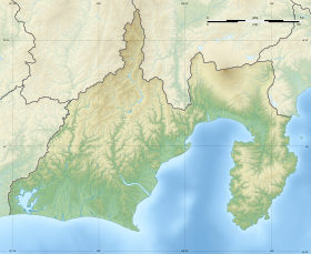
Действующий вулкан Фудзияма находится на самом большом острове Японского архипелага Хонсю. От Токио, столицы Японии, что расположена на этом же острове, священная гора размешается в 90 км на юго-запад (на географической карте мира Фудзияму можно отыскать по следующим координатам: 35° 21′ 45″ с. ш, 138° 43′ 50″ в. д.).

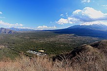
Японцы искренне убеждены в том, что гора Фудзияма, самая высокая гора Японии, и является одной из самых красивых природных достопримечательностей страны. В начале прошлого века здесь был основан Национальный парк Фудзи-Хаконэ-Идзу, в составе которого оказался вулкан и расположенный у его подножья район Пяти озёр.
Гора, как и местность вокруг неё, государству не принадлежит, а является частной собственностью, что принадлежит великому храму Хонгу Сэнгэн.
Как выглядит священная гора
На склонах вулкана и у его подножья раскинулся лес, а также расположено огромное количество термальных источников, образовавших небольшие тёплые озёра. Искупаться в них, правда, осмелится не каждый: температурные показатели воздуха летом у подножья горы составляют лишь +18°С, а зимой на вершине вулкана царит лютый холод, при этом столбик термометра колеблется в районе –30°С (максимально зафиксированные показатели по состоянию на зиму 2015 года составляли –38°С).
Сам вулкан Фудзияма примечателен тем, что имеет почти идеальную коническую форму (своему виду он обязан базальтовой лаве, которая в своё время толстым слоем укрыла склоны горы). При этом:
- высота вулкана – 3776 м над у. м;
- длина основания – около 126 км;
- диаметр кратера – 500 метров, а глубина – 200.
На вершине Фудзи находится сионистский храм (дзиндзя), почта и метеорологическая станция. Поскольку на горе находится самая высокая точка Японии, именно отсюда удобней всего наблюдать за погодой.
Возникновение
Так как территория, на которой расположены Японские острова, входит в состав Тихоокеанского огненного кольца, здесь насчитывается огромное количество как действующих, так и потухших огнедышащих гор. Если внимательно посмотреть на карту Хонсю, то можно обнаружить, что только на этом острове расположено более двадцати вулканов (половина из них извергалась в прошлом, а некоторые даже в этом столетии).
Что касается Фудзи, то эта гора находится на стыке сразу нескольких литосферных плит: Филиппинской, Евразийской и Охотской. Появилась она не сразу: сначала был сформирован Сен-Комитакэ, а после его крушения – Комитакэ, но и тот долго не простоял.
Восемьдесят тысяч лет назад вместо него появился «Старый Фудзи», который через 20 тыс. лет начал проявлять постоянную вулканическую активность, длившуюся на протяжении десяти столетий, и в результате вулкан оказался уничтожен.
Вместо него 11 тыс. лет назад появился молодой вулканический конус, «Юный Фудзи», на склонах которого впоследствии образовалось более сотни боковых расщелин. А некоторое время спустя извергаемые им потоки базальтовой лавы перекрыли дорогу рекам, истоки которых начинались на севере от Фудзиямы, сформировав Пять озёр Фудзи.
Извержения Фудзи
За всю историю наблюдения за вулканом начиная с 781 г. н. э., сейсмологи зафиксировали двенадцать извержений Фудзиямы, сильнейшее из которых произошло в начале XVIII в. С восточной стороны горы были сформированы три новых кратера, а вулканический пепел засыпал улицы Токио, расположенного почти в ста километрах от Фудзи, 15-метровым слоем. По состоянию на 2015 год это извержение является последним, поэтому на данный момент он считается действующим вулканом с низкой степенью извержения.
С таким определением согласны далеко не все. В последнее время учёные все больше говорят о пробуждении Фудзи: специальные приборы зафиксировали, что давление в магматическом бассейне вулкана по состоянию на 2015 год намного больше, чем это было во время его последнего извержения. Немаловажную роль в этом сыграло девятибалльное землетрясение 2011 года, вызвавшее огромнейшее цунами, затопившее ряд прибрежных японских городов.
О приближающемся землетрясении, которое может спровоцировать извержение вулкана, свидетельствует также поднятие уровня воды в озере Сай, одном из Пяти озер вулкана, многочисленные выбросы пара из жерла и увеличение количества вулканических землетрясений. В 2012 году геологи обнаружили, что под Фудзи проходит линия сброса шириной около 35 км, вдоль которой вполне может произойти землетрясение, после чего начнётся извержение (учёные даже утверждают, что это может случиться между 2015-2020 годами).
Прогнозы некоторых исследователей слишком уж пессимистичны, поскольку они допускают, что извержение будет настолько мощным, что Фудзи полностью исчезнет с лица земли, а огромное количество людей вынуждены будут покинуть свои дома. Правда, с этим согласны далеко не все – большинство учёных всё же склоняются к мысли, что вулкан просыпается постепенно, а магма движется очень медленно, поэтому если вулкан начнёт проявлять чрезмерную активность, людей успеют эвакуировать, хотя сельскому хозяйству ущерб будет нанесён однозначно.
Покорить гору
Поскольку вулкан Фудзияма относительно невысок (особенно если сравнивать с Эверестом, Килиманджаро, Эльбрусом, высота которых значительно превышает 5 тыс. метров), взобраться на его вершину для здорового человека особой сложности не представляет. Согласно статистическим данным на 2015 год, ежегодно на вершину священной горы Японии поднимается более двухсот тысяч человек, тридцать процентов из которых – иностранцы.
Оптимальными месяцами, когда специалисты советуют совершить восхождение на Фудзияму, является июль и август. В это время снег полностью сходит, что значительно облегчает подъём. В другое время вулкан покрыт толстенным пластом снега, из-за которого непрофессиональным и неподготовленным альпинистам совершить подъём на вершину будет сложно, даже с наличием проводника, необходимым снаряжением и картой.
На вершину вулкана проложено четыре маршрута, подъём по которым занимает от трёх до восьми часов. Выбрасывать мусор и даже справлять нужду в неприспособленных для этого местах категорически запрещено. Об этом постоянно предупреждают установленные по всему маршруту таблички, а проводники обязательно выдают туристам бесплатные мусорные пакеты. Немало здесь установлено платных биотуалетов, большинство которых работают в автоматическом режиме и заряжаются от солнечных батарей.
Содержание
- 1 Описание вулкана Фудзияма
- 2 Где находится вулкан Фудзияма
- 3 История вулкана Фудзияма
- 4 Извержения
- 5 Интересные факты
Вулкан Фудзияма заслуженно считают визитной карточкой Японии. Несмотря на грозную силу, таящуюся внутри, заснеженная вершина великой горы смотрится живописно, и на протяжении многих веков является для японцев олицетворением красоты, грации, вдохновения.
Описание вулкана Фудзияма
Фудзияма – действующий вулкан, расположенный на острове Хонсю, всего в 90 км от столицы государства, города Токио. Его абсолютная высота составляет 3776 метра выше уровня моря. Это высочайший пик на территории Японии.
Глубина кратера – примерно 200 метров, ширина жерла в диаметре – 500 метров. Впечатляющие размеры горы породили красивые легенды: буддисты считают кратер вратами в потусторонний мир, синтоисты утверждают, что вершина горы связывает два мира, земной и небесный.
В японском переводе название «Фудзияма» (Фудзи, Фудси-сан) соответствует сущности достопримечательности и означает «огненная гора».
Где находится вулкан Фудзияма
Расположение вулкана – остров Хонсю, префектура Сидзуоко. Географические координаты: 35 градусов северной широты, 138 градусов восточной долготы.
Вокруг Фудзиямы раскинулся национальный парк «Фудзи-хаконе-Идзу». Красоты местной природы влекут путешественников: добраться до самой высокой горы Японии не составит труда. Из Токио регулярно отправляются скоростные поезда, комфортабельные автобусы, моментально доставляющие в пункт назначения.
История вулкана Фудзияма
Изучая карту, ученые установили: гора Фудзи расположена на линии Тихоокеанского огненного кольца. Непосредственно под ней находится стык сразу трех литосферных плит. Этим и обусловлена сейсмическая активность местности.
История вулкана начинается приблизительно 80 тысяч лет назад. На месте тектонических разломов постоянно возникали действующие вулканы. Они извергались настолько часто, что существовали всего несколько десятков лет, разрушаясь от собственной чрезмерной активности: Сен-Комитакэ, Комитакэ, Старый Фудзи.
Новый Фудзи, привлекающий сегодня туристов, образовался около 11 тысяч лет назад. Горячая лава, непрестанно сочащаяся из широких расщелин, перекрыла путь мирно текущим рекам: так образовались Пять озер, ставших одной из красот местной природы.
Японцы всегда относились к горе, как к священному месту. Она воспевалась поэтами, насчет ее предназначения, происхождения создавались красивые легенды.
Извержения
Вулкан Фудзияма, по типу принадлежащий к стартовулканам – спящий, но не потухший. Последний раз извержение происходило в 1707 году. Это был продолжительный, разрушительный процесс, спровоцированный произошедшим незадолго до этого землетрясением. В течение двух недель близлежащие деревни посыпались пеплом. Пострадали сельскохозяйственные угодья, вызвав гибель населения от голода. Город Эдо (современный Токио) покрылся 15-сантиметровым слоем пепла.
Всего за долгую историю наблюдений (с 718 года) зафиксировано 12 извержений Фудзиямы. Отдельно остановиться стоит на следующих:
- 800 год – в результате деятельности вулкана пеплом засыпан тракт, связывающий японские поселения;
- 864 год – гора извергалась в течение двух месяцев. Лава погребла близлежащие поселки, поток горячей жидкости разделил озеро Сэнуоми на два других, размерами поменьше. Выжженная земля долго не могла оправиться: лес на месте катастрофы восстановился через тысячелетие.
После последнего извержения прошло более трехсот лет, но Фудзияма по-прежнему опасен: гора может пробудиться в любой момент. Вулканологи неустанно наблюдают за дремлющим символом Страны Восходящего Солнца: порой над кратером появляется легкий дымок, напоминающий людям о том, что пробуждение монстра – вполне реальная перспектива.
Интересные факты
Как любая достопримечательность, Фудзияма поражает обилием интересных фактов, связанных с его историей, наблюдениями ученых, современными реалиями. Вот лишь некоторые из них:
- Вершина стратовулкана в течение всего года покрыта снегом.
- Официально символ Японии принадлежит синтоистскому храму Хонгу.
- На смертельно опасной горе находятся, помимо храма Хонгу, почтовое отделение, метеорологическая станция.
- Ежегодное количество посетителей вулкана – свыше 200 тысяч.
- Считается, что название вулкана приносит удачу в бизнесе: около сотни японских компаний используют его имя.
- Живописная гора, считающаяся образцом изящества, ни разу не была запечатлены художниками.
- Форма вулкана – конус с идеальными пропорциями.
- Фудзи помогает стать удачливее: достаточно встретить рассвет в храме, расположенном на вершине вулкана.
- Полюбоваться видом сверху позволяют восхождения на гору. Разрешенный период для альпинизма – июль, август.
- Фудзияма – самое притягательное место для иностранных туристов.
- В ясный день гору видят жители Токио.
- Первое восхождение на Фудзи произошло в 663 году: его совершил буддийский монах. Первым европейцем, совершившим подобное, стал британский дипломат Рутерфорд Алкок в 1860 году.
Японцы издавна придают Фудзияме особое значение, относятся к чуду природы трепетно, уважительно. Иностранные путешественники, прибывшие с материка, считают долгом посетить опасную, но при этом невероятно прекрасную гору. Приехать в Японию и обойти вниманием главный символ Страны Восходящего Солнца – непростительное упущение.
Вулкан Фудзияма – кроме того, что это действующий вулкан, является и самой высокой горой Японии, высота которой 3776 м. над уровнем моря. Вулкан расположен на острове Хонсю, к юго-западу от столицы Токио. В 2013 году он был включен в Список всемирного наследия ЮНЕСКО как объект культурного наследия и источника художественного вдохновения. Это вулкан почитается как священная гора и является визитной карточкой Японии.
Геологические характеристики
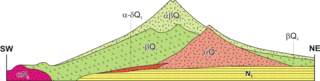
Происхождение Фудзиямы, на топографию которого повлияла вулканическая активность, неизвестно. Согласно народной традиции, гора образовалась после землетрясения в 286 г. до н.э. Вулканологи считают, что нынешний вулкан — это результат четырех отдельных фаз вулканической активности, характеризующие его форму и структуру. Правильная коническая форма горы является следствием наложения слоев затвердевшей лавы и вулканического пепла.
Главный
кратер вулкана Фудзияма расположен на разломе, который является частью
Тихоокеанского пояса, между Евразийской плитой, Охотской плитой и Филиппинской
плитой. Хотя основная фаза вулканической
деятельности Фудзиямы происходила 11-8 тысяч лет назад, вулкан не считается
потухшим. С 781 г. произошло 10 извержений, в том числе три значительных. Последнее извержение произошло с 28
октября 1707 года по 1 января 1708 года. Оно сопровождалось сильным
землетрясением 28 октября 1707 года.

Следствием
вулканической деятельности и расслоения структуры вулкана Фудзияма, является
150 затвердевших лавовых потоков, среди которых самыми большими являются потоки
Мисимы и Мано. Эти потоки, создали многочисленные естественные пещеры с
лавовыми камнями вдоль склонов горы.
Помимо
пещер, можно также наблюдать характерные «лавовые деревья» (лавовое
покрытие вокруг ствола дерева, оставленное потоком лавы).
Поверхность
горы покрыта долинами и ущельями, образовавшихся в результате коррозии ветра,
воды и снега на протяжении веков. Самое большое и обширное из этих ущелий, идет
до западной стороны вершины на высоте около 2200 м. Ущелье имеет 2 км в длину
при ширине 500 м, а глубина составляет 150 м.
Климатические условия

Из-за большой высоты пика, вдоль его склонов
находятся различные типы климата. Большая часть горы имеет альпийский климат, характеризующийся холодными
температурами и сильными ветрами, дующими с запада на северо-запад. Из-за
сильной турбулентности, 5 марта 1966 года Boeing 707 911 врезался в гору, что
привело к гибели 124 человек на борту.
Вершина не
покрыта снегом только короткий период, в летние месяцы, хотя внезапные
снегопады могут происходить даже в самое жаркое время года.
Туристическое развитие вулкана Фудзияма
Вулкан
Фудзияма можно увидеть с бесчисленных точек в окружающих регионах. В ясные дни
его пик виден на расстоянии сотен километров; однако чаще всего вид на вершину
горы затруднен низкими висящими облаками или плохой видимостью.
Вулкан и его
массив являются местом многочисленных
туристических поездок и паломничества. Официальный сезон скалолазания —
июль и август. На самом верху проходят четыре туристических маршрута с десятью
платными туристическими хижинами. До 2400 м над уровнем моря летом туда можно добраться по асфальтовой дороге
на автомобиле или круизном автобусе. На вершине работает метеорологическая
обсерватория.

Рядом с вулканом Фудзияма, в префектуре Яманаси расположены озера:
- Кавагути;
- Яманака;
- Сай;
- Мотосу;
- Сёдзи.
Гора
официально открыта для скалолазания в июле и августе по нескольким маршрутам.
В июне 2009
года был открыт японский аэропорт горы «Фудзи Сидзуока» для нескольких
внутренних и внешних авиалиний.
На
юго-западной стороне расположены водопады Ширайто, а на северо-западной стороне
лыжные районы Фуджитен. Весь район является целью массового туризма и частью национального парка Фудзи-Хаконэ-Идзу.
Он также включает в себя равнину и печально известный лес Аокигахара.
Гора
официально открыта для скалолазания в июле и августе по нескольким маршрутам.
В июне 2009
года был открыт японский аэропорт горы Фудзи
Сидзуока для нескольких внутренних и внешних авиалиний.
Значение в культуре

Отличительный силуэт вулкана, вершина которого покрыта снегом в течение большей части года, популярный мотив в искусстве. Знаменитые горные пейзажи запечатлены в виде ксилографий из двух серий под одним и тем же названием: «36 видов на гору Фудзи» (Хокусай), « 36 видов на гору Фудзи» (Хиросигэ), были созданы отдельно двумя художниками по имени Хокусай Кацусика и Хиросигэ Андо. Хокусай повторил эту тему в иллюстрированной книге, изданной в трех томах под названием «Сто видов на гору Фудзи» в 1834-1849 годах.
Фудзияма также является священной горой для последователей синтоизма, как женское божество Конохана-но-сакуйахиме-но-микото. Она считается одной из «трех священных гор» страны, вместе с горой Тейт и горой Хаку.
Вулкан Фудзияма на карте
Интересное:
японская подстилка футон
япония на карте мира и её географическое положение
Гора Фудзияма (Фудзи)
Большинство национальных символов в мире — рукотворные: статуя Свободы, Эйфелева башня, Кремль, Великая Китайская стена… В Японии же это природное явление, хотя благодаря его почти полной симметрии заснеженный даже летом конус Фудзиямы настолько гармонично сложен, что скорее представляется произведением бесконечно терпеливого ландшафтного дизайнера, а не следствием вулканической деятельности. Величественный одинокий пик возносится к небесам на высоту 3776 м. Словом, он просто красив. Здесь более чем в любом храмовом саду или на территории древнего замка становится понятно, почему японцы предпочитают размытые грани между природой и искусством.
Считается, что название вулкана произошло от слова из языка айну, означающего «огонь». Вулкан Фудзияма последний раз извергался в 1707 г., и ныне через его кору лишь время от времени прорываются клубы пара, подобные размеренному дыханию спящего великана. Сон его кажется крепким — к счастью для сотен тысяч людей, ежегодно поднимающихся на вершину. Для одних подъем — священнодействие, ведь гора почитается как обитель древних японских богов. Для других это акт укрепления самодисциплины и способ физического очищения. У третьих восхождение не вызвано никакими религиозными импульсами, и они приезжают сюда во время отпуска, чтобы потом сказать, что побывали здесь, хотя уезжают, к удивлению для самих себя, с ощущением сильного духовного подъема. Никакой туристический буклет не в силах сделать Фудзияму банальным туристическим аттракционом, и даже самые пресытившиеся красотами мира путешественники не останутся безучастными к тому, что предстанет перед их взором.
Видео: Фудзияма
Подъем на Фудзияму
Большинство начинает подъем у озера Кавагути, в курортной зоне к северу от горы после примерно двухчасовой поездки из Токио на поезде. Официальный сезон восхождений продолжается с 1 июля по 27 августа, однако горные приюты всех десяти станций на разных маршрутах подъема открыты с апреля по середину ноября. Подниматься на гору «вне сезона» (в особенности в сырую погоду) не рекомендуется, однако люди делают это в любое время.
Из Кавагути вы на местном автобусе доедете до Го-гоме («Пятая станция») на северном склоне, откуда можно начать пятичасовой подъем к вершине. Вы доедете сюда и напрямую из Токио на автобусе, отправляющемся с автостанции Синдзюку; время в пути около 2,5 ч. Если приезжаете из Киото или Осаки, поезд или автобус доставит вас к маршруту Фудзино-мийа, проложенному по южному склону.
Настоящие пилигримы начинают подъем около полуночи, достигая вершины к восходу солнца. Тропа хорошо промаркирована, а потому нет риска заблудиться. К тому же ночной подъем позволяет обойтись без ночевки в одном из приютов с общими спальнями (условия, по правде сказать, ужасные). Вы сможете остановиться отдохнуть на седьмой или восьмой станции. Захватите с собой теплую одежду, наденьте удобную обувь, головной убор и перчатки. Приобрести на вершине можно только снеки из автоматов, а потому стоит запастись провизией, а главное — термосом с кофе или чаем.
В одном отношении Фудзияма подобна любой другой горе — спускаться гораздо легче, чем подниматься. Более авантюрно настроенные восходители смогут проделать обратный путь по усеянному вулканическим песком спуску до Син-Го-гоме («Новая пятая станция»). Вы просто садитесь верхом на свой рюкзак или кусок картона и скользите вниз. От Син-Го-гоме автобус доставит вас в городок Готемба, где можно будет пересесть на другой транспорт.
Окрестности Фудзиямы
Не ограничивайте свой приезд в эти места одной только горой. Пять озер Фудзиямы, дугой охватывающие подножие горы с севера, привлекательны отличной рыбалкой, катанием на лодках и пешими прогулками. Самое крупное — Яманака-ко. Кавагути-ко — самое популярное, вероятно, благодаря наличию курсирующих вдоль северного берега экскурсионных судов, с борта которых в тихую и ясную погоду можно любоваться идеальным зеркальным отражением Фудзиямы в воде. На Сай-ко — лучшая рыбалка на форель, а Сёдзи-ко — самое маленькое, красивое и относительно неосвоенное человеком. Мотосу-ко — самое прозрачное и глубокое.
Между Сай-ко и Сёдзи-ко раскинулся густой и таинственный лес Дзюкай («Море деревьев»), примечательный тем, что в него легче войти, чем из него выйти. Вулканическая порода делает магнитный компас абсолютно бесполезным. Многие здесь блудят, некоторые намеренно: жутковатый Дзюкай пользуется неизменной популярностью у самоубийц, и местные власти ежегодно прочесывают лес в поисках тел, которые в противном случае никогда не были бы найдены. Находящийся к югу от Мотосу-ко сверкающий вспененной водой водопад Сирайто высотой 26 м — гораздо более приятное место для пикника.
Фудзияма
- Адрес: Фудзиномия, Префектура Сидзуока 418-0112, Япония
- Горная система: Японские Альпы
- Форма вулкана: Стратовулкан
- Диаметр кратера: около 500 м
- Глубина кратера: около 200 м
- Последнее извержение: 1708 г.
- Высота вершины: 3776 м

Фудзияма является символом Японии. Самая высокая гора в стране символизирует воплощение связи древних традиций и современных принципов жизни. Фудзияма имеет идеальную симметрию, поэтому японцы считают ее эталоном красоты. Сюда приходят художники и поэты, чтобы получить вдохновение, а туристы – чтобы полюбоваться красотой легендарной горы.
Краткое описание горы Фудзиямы в Японии
Высота горы Фудзияма в Японии составляет 3776 м. Вершина часто прячется в облаках, поэтому те, кто смог увидеть Фудзи полностью, созерцают невероятную красоту. Очертания кратера имеют сходство с цветком лотоса. Лепестками выступают большие гребни, местные жители их прозвали Яксудо-Фуйо. Возраст горы около 10 000 лет, что определяет ее в стратовулканы.

Многих интересует вопрос: Фудзияма действующий или потухший вулкан? На сегодняшний день сейсмической угрозы он не представляет, при этом относится к слабоактивным, то есть спящим. Несмотря на это, гора служит объектом туризма и религиозного паломничества, который ежегодно посещают сотни тысяч людей. Но вместе с тем каждый житель Токио знает тот факт, что после последнего извержения Фудзиямы, в 1707 году, город был покрыт пятнадцатисантиметровым слоем пепла. Поэтому вулкан находится под пристальным вниманием ученых.
Как переводится «Фудзияма»?
Удивительно, но тайна названия всемирно известной горы до сих пор полностью не раскрыта. Согласно современным японским иероглифам «фудзияма» обозначает «обилие» и «богатство». Но вряд ли такая трактовка имела место 10 тысяч лет назад. Летопись, датированная Х веком, указывает на то, что название горы обозначает «бессмертие», что, по мнению многих ученых, ближе к истине.
Туризм на Фудзияме
Остров с Фудзиямой – Хонсю – является самым большим, относящемся к Японскому архипелагу, поэтому здесь всегда много гостей из других стран. А сам вулкан известен как туристический объект далеко за пределами своей родины. К тому же гору очень часто посещают буддисты и синтоисты, так как на западном склоне находится Большой провал, вокруг которого расположено много религиозных сооружений. К ним тянется с самого подножья широкая тропа, по которой ежегодно проходят десятки тысяч паломников.
Наиболее удобным и безопасным периодом для подъема на Фудзияму являются месяца июль и август, потому как в остальное время гора покрыта снегом, и массовый туризм недоступен. Весь туристический сезон на Фудзи работают службы спасения, а также открыты горные домики, которые называются ямагоя. В них можно отдохнуть на удобных спальных полках, перекусить, купить продукты и напитки.

Подъем на Фудзияму может проходить по одному из четырех основных маршрутов: Кавагутико, Субасири, Готэмба и Фудзиномия. Эти маршруты относятся к средней сложности, так как начинаются они с пятого уровня горы. Также есть четыре маршрута, которые берут начало у самого подножья – это Мураяма, Ёсида, Суяма и Сёдзико. Они длятся дольше предыдущих и рассчитаны на более подготовленных туристов.
Восхождение на вулкан не обязательно должно быть долгим. На северном склоне горы находится платная автомобильная трасса. По ней курсируют автобусы. Они привозят туристов к большой парковке, где находится много ресторанов и кафе, а также ямогоя. И уже оттуда можно совершить восхождение на вершину Фудзиямы, которое может занять от трех до восьми часов в зависимости от выбранного маршрута.

Полеты над Фудзи
Полеты на параплане с вершины Фудзиямы – это развлечение, которое под силу не каждому. Во-первых, погодные условия далеко не всегда способствуют безопасному полету. Часто спортсменов и туристов возвращают вниз, когда они уже одели костюмы и прошли инструкцию. Это происходит из-за резких порывов ветра, которые могут появиться внезапно. Во-вторых, для того чтобы совершить полет над вулканом, необходимо проснуться ночью и прибыть на место ранним утром. Но то зрелище, которое можно увидеть во время полета, стоит всех сложностей. Пролетая над лесом у подножья горы Фудзиямы, вы сможете оценить всю красоту не только самой горы, но и ее окрестностей – Национального парка Фудзи-Хаконе-Идзу. И всё это – с высоты птичьего полета.

Почему Фудзияма является священной горой?
То, что японская гора Фудзияма считается святыней, ни для кого не секрет, но что придает ей святости –понятно далеко не каждому европейцу. Вулкан имеет канонически идеальные формы, при этом часто на треть покрыт облаками. Издавна этому придавался сакральный смысл. Эффект усиливает тропа на высоте 2500 м, окаймляющая гору. Паломники уверены, что она указывает на путь в иной мир.
Согласно древней легенде о Фудзияме, кратер считается кузницей бога огня Айну. Конечно, далекие предки могли и не знать о том, что такое вулкан, и по-иному бурление лавы с последующим извержением объяснить не могли. Так или иначе, уже на протяжении тысячелетий люди, исповедующие буддизм и синтоизм, считают Фудзияму главной святыней.

Интересные факты о горе Фудзияма
И, конечно, столь важная достопримечательность не могла не обрасти фактами, интересными каждому любознательному человеку:
- Вулкан Фудзияма является частным владением. Ее собственник – это синтоистский Великий храм Хонгу Сэнгэн. Он получил вулкан по дарственной в 1609 году, а в 1974 году верховный суд Японии подтвердил подлинность документа.
- До конца XIX века восхождение на гору Фудзи разрешалось только мужчинам. Во время правления Менде, которое длилось с 1868 до 1912 года, женщины получили разрешение на полноценное посещение горы. На сегодняшний день большую часть паломников составляют именно женщины.
- Многие японские компании включают в свое название имя горы, поэтому не удивляйтесь, если на каждом шагу вы будете видеть вывески со словом «fuji».
- На туристических маршрутах, ведущих к вершине Фудзиямы, расположены платные туалеты. Это очень необычно для Японии, ведь по всей стране они совершенно бесплатные.

Где находится гора Фудзияма?
Гора находится всего в 90 км от Токио, на острове Хонсю и является частью Национального парка Фудзи-Хаконе-Йдзу. Географические координаты вулкана Фудзияма на карте 35°21′45″ с. ш. 138°43′50″ в. д. Ориентирами для поиска могут служить города Иокогама и Миямаэ-Ку, рядом с которыми расположился вулкан. Гора Фудзияма является самой популярной в Японии, и ее фото украшают все путеводители, поэтому найти ее достаточно просто.

Как добраться из Токио до Фудзиямы?
Один из способов добраться до достопримечательности – это скоростная автомагистраль, по которой дорога на автомобиле займет 1,5-2 часа.
Также можно воспользоваться экспресс-автобусами, которые отправляются от автовокзала Синдзюки с интервалом в час. Первый отходит в 6:40 утра, а последний – в 19:30. Цена билета составляет $23,50. Дорога займет около 2,5 часа.
Не стоит забывать про туристические агентства, которые предлагают экскурсии на Фудзияму из Токио. За вами могут заехать в отель или забрать в другом удобном месте, стоимость экскурсии от $42.
| Mount Fuji | |
|---|---|

Mount Fuji seen from Ōwakudani |
|
| Highest point | |
| Elevation | 3,776.25 to 3,778.23 m (12,389.3 to 12,395.8 ft) |
| Prominence | 3,776 m (12,388 ft)[1] Ranked 35th |
| Isolation | 2,077 km (1,291 mi) |
| Listing |
|
| Coordinates | 35°21′38″N 138°43′39″E / 35.36056°N 138.72750°E[2] |
| Naming | |
| Native name | 富士山 (Japanese) |
| Pronunciation | [ɸɯꜜ(d)ʑisaɴ] |
| Geography | |
|
Mount Fuji Location of Mount Fuji in Japan
Mount Fuji Mount Fuji (Shizuoka Prefecture) |
|
| Location | Fuji-Hakone-Izu National Park |
| Country | Japan |
| Prefectures | Shizuoka and Yamanashi (with the summit in neither[citation needed]) |
| municipal | Fuji, Fujinomiya, Fujiyoshida, Gotemba, Narusawa and Oyama |
| Topo map | Geospatial Information Authority 25000:1 富士山[3] 50000:1 富士山 |
| Geology | |
| Age of rock | 100,000 years |
| Mountain type | Stratovolcano |
| Last eruption | 1707–08 |
| Climbing | |
| First ascent | 663 by En no Odzunu (役行者, En no gyoja, En no Odzuno) |
| Easiest route | Hiking |
|
UNESCO World Heritage Site |
|
| Official name | Fujisan, sacred place and source of artistic inspiration |
| Criteria | Cultural: iii, vi |
| Reference | 1418 |
| Inscription | 2013 (37th Session) |
| Area | 20,702.1 ha |
| Buffer zone | 49,627.7 ha |

| Mount Fuji | |||
|---|---|---|---|
«Mt. Fuji» in kanji |
|||
| Japanese name | |||
| Kanji | 富士山 | ||
|
Mount Fuji (富士山, Fujisan, Japanese: [ɸɯꜜ(d)ʑisaɴ] (![]() listen)), or Fugaku, located on the island of Honshū, is the highest mountain in Japan, with a summit elevation of 3,776.24 m (12,389 ft 3 in). It is the second-highest volcano located on an island in Asia (after Mount Kerinci on the island of Sumatra), and seventh-highest peak of an island on Earth.[1] Mount Fuji is an active stratovolcano that last erupted from 1707 to 1708.[4][5] The mountain is located about 100 km (62 mi) southwest of Tokyo and is visible from there on clear days. Mount Fuji’s exceptionally symmetrical cone, which is covered in snow for about five months of the year, is commonly used as a cultural icon of Japan and it is frequently depicted in art and photography, as well as visited by sightseers and climbers.[6]
listen)), or Fugaku, located on the island of Honshū, is the highest mountain in Japan, with a summit elevation of 3,776.24 m (12,389 ft 3 in). It is the second-highest volcano located on an island in Asia (after Mount Kerinci on the island of Sumatra), and seventh-highest peak of an island on Earth.[1] Mount Fuji is an active stratovolcano that last erupted from 1707 to 1708.[4][5] The mountain is located about 100 km (62 mi) southwest of Tokyo and is visible from there on clear days. Mount Fuji’s exceptionally symmetrical cone, which is covered in snow for about five months of the year, is commonly used as a cultural icon of Japan and it is frequently depicted in art and photography, as well as visited by sightseers and climbers.[6]
Mount Fuji is one of Japan’s «Three Holy Mountains» (三霊山, Sanreizan) along with Mount Tate and Mount Haku. It is a Special Place of Scenic Beauty and one of Japan’s Historic Sites.[7] It was added to the World Heritage List as a Cultural Site on June 22, 2013.[7] According to UNESCO, Mount Fuji has «inspired artists and poets and been the object of pilgrimage for centuries». UNESCO recognizes 25 sites of cultural interest within the Mount Fuji locality. These 25 locations include the mountain and the Shinto shrine, Fujisan Hongū Sengen Taisha.[8]
Etymology[edit]
The current kanji for Mount Fuji, 富 and 士, mean «wealth» or «abundant» and «man of status» respectively. However, the origins of this spelling and of the name Fuji continue to be debated.
A text of the 9th century, Tale of the Bamboo Cutter, says that the name came from «immortal» (不死, fushi, fuji) and also from the image of abundant (富, fu) soldiers (士, shi, ji)[9] ascending the slopes of the mountain.[10] An early folk etymology claims that Fuji came from 不二 (not + two), meaning without equal or nonpareil. Another claims that it came from 不盡 (not + to exhaust), meaning never-ending.
Hirata Atsutane, a Japanese classical scholar in the Edo period, speculated that the name is from a word meaning, «a mountain standing up shapely as an ear (穗, ho) of a rice plant». British missionary John Batchelor (1854–1944) argued that the name is from the Ainu word for «fire» (fuchi) of the fire deity Kamui Fuchi, which was denied by a Japanese linguist Kyōsuke Kindaichi on the grounds of phonetic development (sound change). It is also pointed out that huchi means an «old woman» and ape is the word for «fire», ape huchi kamuy being the fire deity. Research on the distribution of place names that include fuji as a part also suggest the origin of the word fuji is in the Yamato language rather than Ainu. Japanese toponymist Kanji Kagami argued that the name has the same root as wisteria (藤, fuji) and rainbow (虹, niji, but with an alternative reading, fuji), and came from its «long well-shaped slope».[11][12][13][14]
Modern linguist Alexander Vovin proposes an alternative hypothesis based on Old Japanese reading */puⁿzi/: the word may have been borrowed from Eastern Old Japanese */pu nusi/ 火主 meaning «fire master».[15]
Variations[edit]
In English, the mountain is known as Mount Fuji. Some sources refer to it as «Fuji-san», «Fujiyama» or, redundantly, «Mt. Fujiyama». Japanese speakers refer to the mountain as «Fuji-san». This «san» is not the honorific suffix used with people’s names, such as Watanabe-san, but the Sino-Japanese reading of the character yama (山, «mountain») used in Sino-Japanese compounds. In Nihon-shiki and Kunrei-shiki romanization, the name is transliterated as Huzi.
Other Japanese names which have become obsolete or poetic include Fuji-no-Yama (ふじの山, «the Mountain of Fuji»), Fuji-no-Takane (ふじの高嶺, «the High Peak of Fuji»), Fuyō-hō (芙蓉峰, «the Lotus Peak»), and Fugaku (富岳/富嶽), created by combining the first character of 富士, Fuji, and 岳, mountain.[16]
History[edit]


Mount Fuji from Omiya, c. 1890
Mount Fuji is an attractive volcanic cone and a frequent subject of Japanese art especially after 1600, when Edo (now Tokyo) became the capital and people saw the mountain while traveling on the Tōkaidō road. According to the historian H. Byron Earhart, «in medieval times it eventually came to be seen by Japanese as the “number one” mountain of the known world of the three countries of India, China, and Japan».[17] The mountain is mentioned in Japanese literature throughout the ages and is the subject of many poems.[18]
The summit has been thought of as sacred since ancient times and was therefore forbidden to women. It was not until 1872 that the Japanese government issued an edict (May 4, 1872, Grand Council of State Edict 98) stating, «Any remaining practices of female exclusion on shrine and temple lands shall be immediately abolished, and mountain climbing for the purpose of worship, etc., shall be permitted.”[19] However, Tatsu Takayama (also known as Takayama Tatsu), a Japanese woman, became the first woman on record to summit Mount Fuji in the fall of 1832.[20][21]
Ancient samurai used the base of the mountain as a remote training area, near the present-day town of Gotemba. The shōgun Minamoto no Yoritomo held yabusame archery contests in the area in the early Kamakura period.
The first ascent by a foreigner was by Sir Rutherford Alcock in September 1860, who ascended the mountain in 8 hours and descended in 3 hours.[22]: 427 Alcock’s brief narrative in The Capital of the Tycoon was the first widely disseminated description of the mountain in the West.[22]: 421–27 Lady Fanny Parkes, the wife of British ambassador Sir Harry Parkes, was the first non-Japanese woman to ascend Mount Fuji in 1867.[23] Photographer Felix Beato climbed Mount Fuji two years later.[24]
On March 5, 1966, BOAC Flight 911, a Boeing 707, broke up in flight and crashed near the Mount Fuji Gotemba New fifth station, shortly after departure from Tokyo International Airport. All 113 passengers and 11 crew members died in the disaster, which was attributed to the extreme clear-air turbulence caused by lee waves downwind of the mountain. There is a memorial for the crash a short distance down from the Gotemba New fifth station.[25]
Today, Mount Fuji is an international destination for tourism and mountain climbing.[26][27] In the early 20th century, populist educator Frederick Starr’s Chautauqua lectures about his several ascents of Mount Fuji—1913, 1919, and 1923—were widely known in America.[28] A well-known Japanese saying suggests that a wise person will climb Mt. Fuji once in their lifetime, but only a fool would climb it twice.[29][30] It remains a popular symbol in Japanese culture, including making numerous movie appearances,[31] inspiring the Infiniti logo,[32] and even appearing in medicine with the Mount Fuji sign.[33][34]
In September 2004, the staffed weather station at the summit was closed after 72 years in operation. Observers monitored radar sweeps that detected typhoons and heavy rains. The station, which was the highest in Japan at 3,780 metres (12,402 ft), was replaced by a fully automated meteorological system.[35]
Mount Fuji was added to the World Heritage List as a Cultural Site on June 22, 2013.[7]
Geography[edit]
Mount Fuji as seen from the air and from the window of a bullet train, 2014

Mount Fuji is a very distinctive feature of the geography of Japan. It stands 3,776.24 m (12,389 ft) tall and is located near the Pacific coast of central Honshu, just southwest of Tokyo. It straddles the boundary of Shizuoka and Yamanashi Prefectures. Four small cities surround it: Gotemba to the east, Fujiyoshida to the north, Fujinomiya to the southwest, and Fuji to the south. It is surrounded by five lakes: Lake Kawaguchi, Lake Yamanaka, Lake Sai, Lake Motosu and Lake Shōji.[36] They, and nearby Lake Ashi, provide views of the mountain. The mountain is part of the Fuji-Hakone-Izu National Park. It can be seen more distantly from Yokohama, Tokyo, and sometimes as far as Chiba, Saitama, Tochigi, Ibaraki and Lake Hamana when the sky is clear. It has been photographed from space during a space shuttle mission.[37]
Climate[edit]
The summit of Mount Fuji has a tundra climate (Köppen climate classification ET). The temperature is very low at the high altitude, and the cone is covered by snow for several months of the year. The lowest recorded temperature is −38.0 °C (−36.4 °F) recorded in February 1981, and the highest temperature was 17.8 °C (64.0 °F) recorded in August 1942.
| Climate data for Mt. Fuji (1991–2020 normals, extremes 1932–present) | |||||||||||||
|---|---|---|---|---|---|---|---|---|---|---|---|---|---|
| Month | Jan | Feb | Mar | Apr | May | Jun | Jul | Aug | Sep | Oct | Nov | Dec | Year |
| Record high °C (°F) | −1.7 (28.9) |
0.0 (32.0) |
1.0 (33.8) |
4.7 (40.5) |
12.2 (54.0) |
12.3 (54.1) |
17.4 (63.3) |
17.8 (64.0) |
16.3 (61.3) |
14.0 (57.2) |
6.9 (44.4) |
3.6 (38.5) |
17.8 (64.0) |
| Average high °C (°F) | −15.3 (4.5) |
−14.3 (6.3) |
−10.9 (12.4) |
−5.9 (21.4) |
−0.6 (30.9) |
4.0 (39.2) |
8.0 (46.4) |
9.5 (49.1) |
6.5 (43.7) |
0.7 (33.3) |
−5.9 (21.4) |
−12.2 (10.0) |
−3.0 (26.6) |
| Daily mean °C (°F) | −18.2 (−0.8) |
−17.4 (0.7) |
−14.1 (6.6) |
−8.8 (16.2) |
−3.2 (26.2) |
1.4 (34.5) |
5.3 (41.5) |
6.4 (43.5) |
3.5 (38.3) |
−2.0 (28.4) |
−8.7 (16.3) |
−15.1 (4.8) |
−5.9 (21.4) |
| Average low °C (°F) | −21.4 (−6.5) |
−21.1 (−6.0) |
−17.7 (0.1) |
−12.2 (10.0) |
−6.3 (20.7) |
−1.4 (29.5) |
2.8 (37.0) |
3.8 (38.8) |
0.6 (33.1) |
−5.1 (22.8) |
−11.8 (10.8) |
−18.3 (−0.9) |
−9.0 (15.8) |
| Record low °C (°F) | −37.3 (−35.1) |
−38.0 (−36.4) |
−33.9 (−29.0) |
−27.8 (−18.0) |
−18.9 (−2.0) |
−13.1 (8.4) |
−6.9 (19.6) |
−4.3 (24.3) |
−10.8 (12.6) |
−19.5 (−3.1) |
−28.1 (−18.6) |
−33.0 (−27.4) |
−38.0 (−36.4) |
| Average relative humidity (%) | 53 | 56 | 61 | 63 | 60 | 70 | 79 | 75 | 67 | 53 | 52 | 52 | 62 |
| Source: Japan Meteorological Agency[38] |
See or edit raw graph data.
Geology[edit]


Relief map and animation realized with SRTM data
Mount Fuji is located at a triple junction trench where the Amurian Plate, Okhotsk Plate, and Philippine Sea Plate meet.[40][41] These three plates form the western part of Japan, the eastern part of Japan, and the Izu Peninsula respectively.[42] The Pacific Plate is being subducted beneath these plates, resulting in volcanic activity. Mount Fuji is also located near three island arcs: the Southwestern Japan Arc, the Northeastern Japan Arc, and the Izu-Bonin-Mariana Arc.[42]
Mt. Fuji’s main crater is 780 metres (2,560 ft) in diameter and 240 metres (790 ft) in depth. The bottom of the crater is 100–130 metres (330–430 ft) in diameter. Slope angles from the crater to a distance of 1.5–2 kilometres (0.93–1.24 mi) are 31°–35°, the angle of repose for dry gravel. Beyond this distance, slope angles are about 27°, which is caused by an increase in scoria. Mid-flank slope angles decrease from 23° to less than 10° in the piedmont.[42]

Scientists have identified four distinct phases of volcanic activity in the formation of Mount Fuji. The first phase, called Sen-komitake, is composed of an andesite core recently discovered deep within the mountain. Sen-komitake was followed by the «Komitake Fuji», a basalt layer believed to be formed several hundred thousand years ago. Approximately 100,000 years ago, «Old Fuji» was formed over the top of Komitake Fuji. The modern, «New Fuji» is believed to have formed over the top of Old Fuji around 10,000 years ago.[43]
Pre-Komitake started erupting in the Middle Pleistocene in an area seven kilometres (4+1⁄2 mi) north of Mount Fuji. After a relatively short pause, eruptions began again which formed Komitake Volcano in the same location. These eruptions ended 100,000 years ago. Ashitake Volcano was active from 400,000 to 100,000 years ago, and is located 20 kilometres (12 mi) southeast of Mount Fuji. Mount Fuji started erupting 100,000 years ago, with Ko-Fuji (old-Fuji) forming 100,000 to 17,000 years ago, but which is now almost completely buried. A large landslide on the southwest flank occurred about 18,000 years ago. Shin-Fuji (new-Fuji) eruptions in the form of lava, lapilli and volcanic ash, have occurred between 17,000 and 8,000 years ago, between 7,000 and 3,500 years ago, and between 4,000 and 2,000 years ago. Flank eruptions, mostly in the form of parasitic cinder cones, ceased in 1707. The largest cone, Omuro-Yama, is one of more than 100 cones aligned NW-SE and NE-SW through the summit. Mt. Fuji also has more than 70 lava tunnels and extensive lava tree molds. Two large landslides are at the head of the Yoshida-Osawa and Osawa-Kuzure valleys.[42]
As of December 2002, the volcano is classified as active with a low risk of eruption. The last recorded eruption was the Hōei eruption which started on December 16, 1707 (Hōei 4, 23rd day of the 11th month), and ended about January 1, 1708 (Hōei 4, 9th day of the 12th month).[44] The eruption formed a new crater and a second peak, named Mount Hōei (after the Hōei era), halfway down its southeastern side. Fuji spewed cinders and ash which fell like rain in Izu, Kai, Sagami, and Musashi.[45] Since then, there have been no signs of an eruption. However, on the evening of March 15, 2011, there was a magnitude 6.2 earthquake at shallow depth a few kilometres from Mount Fuji on its southern side. But according to the Japanese Meteorological Service there was no sign of any eruption.[46]
Recorded eruptions[edit]
About 11,000 years ago, a large amount of lava began to erupt from the west side of the top of the ancient Fuji mountain. This lava formed the new Fuji which is the main body of Mount Fuji. Since then, the tops of the ancient Fuji and the new Fuji are side by side. About 2500–2800 years ago, the top part of ancient Fuji caused a large-scale landslide due to weathering, and finally, only the top of Shin-Fuji remained.
There are ten known eruptions that can be traced to reliable records.[47][48]
| Date(s) | Notes | Ref |
|---|---|---|
| July 31, 781 | The eruption was recorded in the Shoku Nihongi and it was noted that «ash fell», but there are no other details. | [49] |
| April 11 – May 15, 800 February 13, 802 |
The Nihon Kiryaku states that during the first phase, the skies were dark even during the daytime. The second phase is known from the Nippon Kiseki, which notes that gravel fell like hail. | [50] |
| June–September 864 December 865 – January 866 |
Both phases were recorded in the Nihon Sandai Jitsuroku. This eruption created three of the Fuji Five Lakes: Motosu, Shōji, and Saiko, from a single lake that became separated by lava flow. | [51] |
| November 937 | This was recorded in the Nihon Kiryaku. | [52] |
| March 999 | It is noted in the Honchō Seiki that news of an eruption was brought to Kyoto, but no other details are known. | [53] |
| January 1033 | According to the Nihon Kiryaku, news of this eruption was brought to Kyoto two months later. | [54] |
| April 17, 1083 | The only contemporary recording of this was written by a Buddhist monk and can be found in the Fusō Ryakuki. Later writings indicate that the sound of the eruption may have been heard in Kyoto. | [55] |
| between January 30, 1435 and January 18, 1436 | A record of this appears in the Ōdaiki, a chronicle kept by the monks at Kubo Hachiman Shrine in Yamanashi City and it states that a flame was visible on Mount Fuji. As there is no mention of smoke, this appears to have been a Hawaiian eruption (lava only). | [56] |
| August 1511 | The Katsuyamaki (or Myōhōjiki), written by monks at Myōhō-ji in Fujikawaguchiko, indicates that there was a fire on Mount Fuji at this time, but as there is no vegetation at the described location, this was almost certainly a lava flow. | [57] |
| December 16, 1707 | The Hōei eruption | [58] |
Current eruptive danger[edit]
|
|
This section needs to be updated. Please help update this article to reflect recent events or newly available information. (November 2022) |
Following the 2011 Tōhoku earthquake, there was speculation in the media that the shock may induce volcanic unrest at Mount Fuji. In September 2012, mathematical models created by the National Research Institute for Earth Science and Disaster Prevention (NRIESDP) suggested that the pressure in Mount Fuji’s magma chamber could be 1.6 megapascals higher than it was before its last eruption in 1707. This was interpreted by some media outlets to mean that an eruption of Mount Fuji could be imminent.[59] However, since there is no known method of directly measuring the pressure of a volcano’s magma chamber, indirect calculations of the type used by NRIESDP are speculative and unverifiable. Other indicators suggestive of heightened eruptive danger, such as active fumaroles and recently discovered faults, are typical occurrences at this type of volcano.[60]
Aokigahara forest[edit]
Aokigahara forest with Mount Fuji and Mount Ashiwada
The forest at the northwest base of the mountain is named Aokigahara. Folk tales and legends tell of ghosts, demons, Yūrei and Yōkai haunting the forest, and in the 19th century, Aokigahara was one of many places poor families abandoned the very young and the very old.[61] Aokigahara is the world’s third most popular suicide location after San Francisco’s Golden Gate Bridge and the Nanjing Yangtze River Bridge.[62] Since the 1950s, more than 500 people have died in the forest, mostly suicides.[62] Approximately 30 suicides have been counted yearly, with a high of nearly 80 bodies in 2002.[63] The recent increase in suicides prompted local officials to erect signs that attempt to convince individuals experiencing suicidal intent to re-think their desperate plans, and sometimes these messages have proven effective.[64] The numbers of suicides in the past creates an allure that has persisted across the span of decades.[65][66]
Many of these hikers mark their travelled routes by leaving coloured plastic tapes behind as they pass, causing concerns from prefectural officials with regard to the forest’s ecosystem.[67]
Adventuring[edit]

A view of Mount Fuji from the Taisekiji temple as depicted by the woodblock artist Katsushika Hokusai. The one hundred views of Mount Fuji. From the Elizabeth Joan Tanney estate, c. 1834.
Transportation[edit]
The closest airport with scheduled international service is Mt. Fuji Shizuoka Airport. It opened in June 2009. It is about 80 kilometres (50 mi) from Mount Fuji.[68] The major international airports serving Tokyo, Tokyo International Airport (Haneda Airport) in Tokyo and Narita International Airport in Chiba are approximately three hours and 15 minutes from Mount Fuji.
Climbing routes[edit]
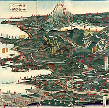
Historical illustration of the routes to Mount Fuji


Hikers climbing Mount Fuji
Approximately 300,000 people climbed Mount Fuji in 2009.[69] The most popular period for people to hike up Mount Fuji is from July to August, while huts and other facilities are operating and the weather is warmest.[69] Buses to the trail heads typically used by climbers start running on July 1.[70] Climbing from October to May is very strongly discouraged, after a number of high-profile deaths and severe cold weather.[71] Most Japanese climb the mountain at night in order to be in a position at or near the summit when the sun rises. The morning light is called 御来光 goraikō, «arrival of light».[72]
There are four major routes to the summit, each has numbered stations along the way. They are (clockwise, starting North): Kawaguchiko, Subashiri, Gotemba, and Fujinomiya routes.[73] Climbers usually start at the fifth stations, as these are reachable by car or by bus. The summit is the tenth station on each trail. The stations on different routes are at different elevations; the highest fifth station is located at Fujinomiya, followed by Yoshida, Subashiri, and Gotemba. There are four additional routes from the foot of the mountain: Shojiko, Yoshida, Suyama, and Murayama routes.[citation needed]
Even though it has only the second-highest fifth stations, the Yoshida route is the most-popular route because of its large parking area and many large mountain huts where a climber can rest or stay. During the summer season, most Mount Fuji climbing tour buses arrive there. The next-popular is the Fujinomiya route, which has the highest fifth station, followed by Subashiri and Gotemba. The ascent from the new fifth station can take anywhere between five and seven hours while the descent can take from three to four hours.[73]
Even though most climbers do not climb the Subashiri and Gotemba routes, many descend these because of their ash-covered paths. From the seventh station to near the fifth station, one could run down these ash-covered paths in approximately 30 minutes. Besides these routes, there are tractor routes along the climbing routes. These tractor routes are used to bring food and other materials to huts on the mountain. Because the tractors usually take up most of the width of these paths and they tend to push large rocks from the side of the path, the tractor paths are off-limits to the climbers on sections that are not merged with the climbing or descending paths. Nevertheless, one can sometimes see people riding mountain bikes along the tractor routes down from the summit. This is particularly risky, as it becomes difficult to control speed and may send some rocks rolling along the side of the path, which may hit other people.
The four routes from the foot of the mountain offer historical sites. The Murayama is the oldest Mount Fuji route and the Yoshida route still has many old shrines, teahouses, and huts along its path. These routes are gaining popularity recently and are being restored, but climbing from the foot of the mountain is still relatively uncommon. Also, bears have been sighted along the Yoshida route.
Huts at and above the fifth stations are usually staffed during the climbing season, but huts below fifth stations are not usually staffed for climbers. The number of open huts on routes are proportional to the number of climbers—Yoshida has the most while Gotemba has the fewest. The huts along the Gotemba route also tend to start later and close earlier than those along the Yoshida route. Also, because Mount Fuji is designated as a national park, it is illegal to camp above the fifth station.
There are eight peaks around the crater at the summit. The highest point in Japan, Ken-ga-mine, is where the Mount Fuji Radar System used to be (it was replaced by an automated system in 2004). Climbers are able to visit each of these peaks.
Paragliding[edit]
Paragliders take off in the vicinity of the fifth station Gotemba parking lot, between Subashiri and Hōei-zan peak on the south side of the mountain, in addition to several other locations, depending on wind direction. Several paragliding schools use the wide sandy/grassy slope between Gotemba and Subashiri parking lots as a training hill.
In culture[edit]

Shinto mythology[edit]
In Shinto mythology, Kuninotokotachi (国之常立神?, Kuninotokotachi-no-Kami, in Kojiki)(国常立尊?, Kuninotokotachi-no-Mikoto, in Nihon Shoki) is one of the two gods born from «something like a reed that arose from the soil» when the earth was chaotic. According to the Nihon Shoki, Konohanasakuya-hime, wife of Ninigi, is the goddess of Mount Fuji, where Fujisan Hongū Sengen Taisha is dedicated for her.
In ancient times the mountain was worshipped from afar. The Asama shrine was set up at the foothills to ward off eruptions. In the Heian period (794–1185) volcanic activity subsided and Fuji was used as a base for Shugendō, a syncretic religion combining mountain worship and Buddhism. Worshippers began to climb the slopes and by the early 12th century, Matsudai Shonin had founded a temple on the summit.[74]
Fuji-kō was an Edo period cult centred around the mountain founded by an ascetic named Hasegawa Kakugyō (1541–1646).[75] The cult venerated the mountain as a female deity, and encouraged its members to climb it. In doing so they would be reborn, «purified and… able to find happiness.» The cult waned in the Meiji period and although it persists to this day it has been subsumed into Shintō sects.[76]
Buddhism[edit]
The Buddhist Hokkeko believers of Nichiren Shoshu sect piously claim that the Dai Gohonzon mandala grants supernatural protection from the Buddhist deities against possible volcanic eruption of Mount Fuji through the daylight morning ritual of Ushitora Gongyo.
Popular culture[edit]
As a national symbol of the country, the mountain has been depicted in various art media such as paintings, woodblock prints (such as Hokusai’s Thirty-six Views of Mount Fuji and 100 Views of Mount Fuji from the 1830s), poetry, music, theater, film, manga, anime, pottery[77] and even Kawaii subculture.
Before its explosive eruption in 1980, Mount St. Helens was once known as «The Fuji of America,» for its striking resemblance to Mount Fuji. Mount Taranaki / Mount Egmont in New Zealand is also said to bear a resemblance to Mount Fuji, and for this reason has been used as a stand-in for the mountain in films and television.
See also[edit]
- List of mountains and hills of Japan by height
- 100 Famous Japanese Mountains
- List of three-thousanders in Japan
- Fuji-Hakone-Izu National Park
- List of World Heritage sites in Japan
- List of elevation extremes by country
- Mount Araido (阿頼度山, Araidosan), Araido Island (阿頼度島), Kuril Islands
- Mount St. Helens, nicknamed «Fuji-san of America» prior to its 1980 eruption
- Sacred mountains
- BOAC Flight 911, a British Boeing 707 plane which crashed on the mountain in 1966.
References[edit]
- ^ a b
«富士山情報コ–ナ–». Sabo Works at Mt.Fuji. - ^ Triangulation station is 3775.63m. «Information inspection service of the Triangulation station» (in Japanese). Geospatial Information Authority of Japan, (甲府–富士山–富士山). Retrieved February 8, 2011.
- ^
«Map inspection service» (in Japanese). Geospatial Information Authority of Japan, (甲府–富士山–富士山). Retrieved February 8, 2011. - ^
«Active Volcanoes of Japan». AIST. Geological Survey of Japan. Retrieved March 7, 2016. - ^
«Mount Fuji». Britannica Online. Retrieved October 17, 2009. - ^ Scheffel, Richard L.; Wernet, Susan J., eds. (1980). Natural Wonders of the World. United States: Reader’s Digest Association. p. 153. ISBN 0-89577-087-3.
- ^ a b c [1] Archived June 27, 2013, at the Wayback Machine
- ^ Centre, UNESCO World Heritage. «Fujisan, sacred place and source of artistic inspiration». UNESCO World Heritage Centre. Retrieved February 11, 2022.
- ^ Although the word 士 can mean a soldier (兵士, heishi, heiji), or a samurai (武士, bushi), its original meaning is a man with a certain status.
- ^ «Japanese Text Initiative theTaketori monogatari«. Etext.lib.virginia.edu. August 31, 2004. Retrieved December 23, 2010.
- ^ «富士山の名前の由来». May 31, 2008. Archived from the original on May 31, 2008. Retrieved December 23, 2010.
- ^ «富士山 – 知泉Wiki». Tisen.jp. October 25, 2006. Retrieved December 23, 2010.
- ^ «地名・富士山の意味». June 3, 2008. Archived from the original on June 3, 2008. Retrieved December 23, 2010.
- ^ «富士山アイヌ語語源説について». Asahi-net.or.jp. Retrieved December 23, 2010.
- ^ Vovin, Alexander (January 1, 2017). «On the Etymology of the Name of Mt. Fuji». Studies in Japanese and Korean Historical and Theoretical Linguistics and Beyond. Languages of Asia. Vol. 16. Brill. pp. 80–89. doi:10.1163/9789004351134_010. ISBN 9789004351134.
- ^ «Fuji-san» (in Japanese). Daijisen. Archived from the original on July 22, 2011.
- ^ H. Byron Earhart (May 9, 2011). «Mount Fuji: Shield of War, Badge of Peace». The Asia-Pacific Journal.
- ^ The Fujiyoshida City Board of Education (2003). «富士山吉田口登山道関連遺跡II». Comprehensive Database of Archaeological Site Reports in Japan. Retrieved September 1, 2016.
- ^ Dewitt, Lindsey E. (March 2016). «Envisioning and Observing Women’s Exclusion from Sacred Mountains in Japan». Journal of Asian Humanities at Kyushu University. 1: 19–28. doi:10.5109/1654566. S2CID 55419374.
- ^ Budgen, Mara (July 4, 2022). «Climb every mountain: Japan’s female mountaineers scale new heights». The Japan Times.
- ^ Intersect. Volumes 9-10, Page 39. Japan, PHP Institute, 1993.
- ^ a b Alcock, Rutherford (1863). The Capital of the Tycoon: A Narrative of Three Years Residence in Japan. Vol. I. London: Longman, Green, Longman, Roberts & Green.
- ^ «Lilian Hope Parkes». The Cobbold Family History Trust. Retrieved February 1, 2020.
- ^ Tucker, Anne Wilkes; et al. (2003). The History of Japanese Photography. p. 30. ISBN 978-0-300-09925-6.
- ^ «ASN Aircraft accident Boeing 707-436 G-APFE Mount Fuji». Aviation Safety Network.
- ^ «Climbing Mount Fuji? route maps» (PDF). pp. 4–5. Archived from the original (PDF) on March 27, 2009. Retrieved December 23, 2010.
- ^ «Climbing Mt. Fuji travel log». ChristmasWhistler. June 30, 2002. Archived from the original on March 5, 2016. Retrieved April 6, 2013.
- ^ «Starr Tells of Escape; American Scientist Found Refuge in a Tokio Temple». New York Times. New York. October 1, 1923.
- ^ Tuckerman, Mike. «Climbing Mount Fuji». Japan Visitor.
- ^ Bremmer, Brian (September 15, 1997). «Mastering Mt. Fuji». Business Week. Archived from the original on January 18, 2013.
- ^ Uchida, Tomu (1955). Bloody Spear at Mount Fuji (血槍富士 Chiyari Fuji).
- ^ «Launching Infiniti». Lippincott. Archived from the original on October 30, 2006.
- ^ Sadeghian H (September 2000). «Mount Fuji sign in tension pneumocephalus». Archives of Neurology. 57 (9): 1366. doi:10.1001/archneur.57.9.1366. PMID 10987907.
- ^ Heckmann JG, Ganslandt O; Ganslandt (April 2004). «Images in clinical medicine. The Mount Fuji sign». The New England Journal of Medicine. 350 (18): 1881. doi:10.1056/NEJMicm020479. PMID 15115834.
- ^
«Weather Station on Mt. Fuji Closes». United Press International. September 30, 2004. Retrieved January 5, 2010. - ^ «Fujisan». Global Volcanism Program. Smithsonian Institution.
- ^ «STS-107 Shuttle Mission Imagery». NASA. January 26, 2003. Archived from the original on February 10, 2003. Retrieved December 16, 2012.
- ^ 気象庁 / 平年値(年・月ごとの値). Japan Meteorological Agency. Retrieved May 19, 2021.
- ^ Miyaji, N. «Geology of Fuji Volcano». Fuji Volcano. Volcano Research Center, Earthquake Research Institute (ERI), University of Tokyo. Retrieved February 27, 2018.
- ^ Moores, Eldridge M.; Twiss, Robert J. (1995). Tectonics. Waveland Press. p. 208. ISBN 978-1-4786-2199-7.
- ^ «Mount Fuji». National Geographic Society. December 6, 2011. Archived from the original on June 12, 2018. Retrieved May 18, 2018.
- ^ a b c d Oguchi, Takashi; Oguchi, Chiaki (2010). Migon, Piotr (ed.). Mt. Fuji: The Beauty of a Symmetric Stratovolcano, in Geomorphological Landscapes of the World. Springer. pp. 303–309. ISBN 9789048130542.
- ^ «Third ancient volcano discovered within Mount Fuji». Japan Times. April 4, 2004.
- ^ Koyama, Masato (March 2007). «宝永四年(1707)噴火 (1707 Eruption)». 富士山歴史噴火総解説 (Database of eruptions and other activities of Fuji Volcano, Japan, based on historical records since AD 781) (in Japanese). Shizuoka University. Retrieved September 25, 2008.
- ^ Hayashi Gahō (1834) [1652]. «Siyun-sai Rin-siyo». Nipon o daï itsi ran or Annales des empereurs du Japon. Translated by Titsingh, Isaac. Paris: Oriental Translation Society of Great Britain and Ireland. p. 416.
- ^ « 6.0 Earthquake east of Tokyo, signs of Mt. Fujiyama unrest is possible » Archived March 3, 2016, at the Wayback Machine, peoplestar.co.uk, Retrieved on March 16, 2011.
- ^ Koyama, Masato. «Database of eruptions and other activities of Fuji Volcano, Japan, based on historical records since AD781» (in Japanese). Shizuoka University. Retrieved 29 July 2021.
- ^ «All about Mount Fuji».
- ^ Koyama, Masato. «天応元年(781)噴火» (in Japanese). Shizuoka University. Retrieved 29 July 2021.
- ^ Koyama, Masato. «延暦十九~二十一年(800~802)噴火» (in Japanese). Shizuoka University. Retrieved 29 July 2021.
- ^ Koyama, Masato. «貞観六~七年(864~866初頭)噴火» (in Japanese). Shizuoka University. Retrieved 29 July 2021.
- ^ Koyama, Masato. «承平七年(937)噴火» (in Japanese). Shizuoka University. Retrieved 29 July 2021.
- ^ Koyama, Masato. «長保元年(999)噴火» (in Japanese). Shizuoka University. Retrieved 29 July 2021.
- ^ Koyama, Masato. «長元五年末(1033初頭)噴火» (in Japanese). Shizuoka University. Retrieved 29 July 2021.
- ^ Koyama, Masato. «永保三年(1083)噴火» (in Japanese). Shizuoka University. Retrieved 29 July 2021.
- ^ Koyama, Masato. «永享七年(1435または1436初頭)噴火» (in Japanese). Shizuoka University. Retrieved 29 July 2021.[permanent dead link]
- ^ Koyama, Masato. «●永正八年(1511)噴火» (in Japanese). Shizuoka University. Retrieved 29 July 2021.
- ^ Koyama, Masato. «宝永四年(1707)噴火» (in Japanese). Shizuoka University. Retrieved 29 July 2021.
- ^ Clark, Liat (September 6, 2012). «Pressure in Mount Fuji is now higher than last eruption, warn experts». Wired. Retrieved September 6, 2012.
- ^ Klemeti, Erik (September 10, 2012). «Doooom! The Perception of Volcano Research by the Media». Wired. Retrieved September 10, 2012.
- ^ «Japan’s harvest of death». The Independent. London. September 17, 2011.
- ^ a b Amazeen, no (December 21, 2005). «Book Review: Cliffs of Despair A Journey to Suicide’s Edge». Monsters & Critics. Archived from the original on August 6, 2012.
- ^ Hadfield, Peter (June 16, 2001). «Japan struggles with soaring death toll in Suicide Forest». The Telegraph. London.
- ^ «Sign saves lives of 29 suicidal people». Daily Yomuri Online. February 24, 2008. Archived from the original on March 2, 2008.
- ^ Yoshitomo, Takahashi (Summer 1988). «Aokigahara-jukai: Suicide and Amnesia in Mt. Fuji’s Black Forest». Suicide and Life-Threatening Behavior. 18 (2): 164–75. doi:10.1111/j.1943-278X.1988.tb00150.x. PMID 3420643.
- ^ Davisson, Jack (February 25, 2021). «The Suicide Woods of Mt. Fuji». Japazine.
- ^ Okado, Yuki (May 3, 2008). «Intruders tangle ‘suicide forest’ with tape». Asahi Shimbun. Archived from the original on May 6, 2008. Retrieved May 3, 2008.
- ^ «Mt. Fuji Shiozuoka Airport Basic Information». Shizuoka Prefecture. Archived from the original on May 16, 2008.
- ^ a b «(title in Japanese)» [The number of climbers of Mount. Fuji in 2009] (in Japanese). Ministry of the Environment.
- ^ «Climbing Season». Official Website for Mt. Fuji Climbing.
- ^ Video: Climbing Mount Fuji, Japan in May (closed season) at Youtube.com
- ^ Glass, Kathy (August 26, 1990). «Climbing Mount Fuji By Night». The New York Times.
- ^ a b «Mountain Trails». Official Website for Mt. Fuji Climbing.
- ^ «Mt. Fuji’s selection as a cultural World Heritage site». Mt. Fuji World Heritage Div., Culture and Tourism Dept, Shizuoka Prefecture. Retrieved November 24, 2020.
- ^ Melton, J. Gordon. Encyclopedia of Religious Phenomena. Canton, MI: Visible Ink Press, 2008, p 231
- ^ Melton, J. Gordon. Encyclopedia of Religious Phenomena. Canton, MI: Visible Ink Press, 2008
- ^ «収蔵品のご紹介 | サンリツ服部美術館». www.sunritz-hattori-museum.or.jp.
- Starr, Frederick (1924). Fujiyama, the Sacred Mountain of Japan. Chicago: Covici-McGee. OCLC 4249926.
External links[edit]
- «Fujisan (Mount Fuji)» (PDF). Japan Meteorological Agency. Archived (PDF) from the original on September 24, 2015.
- Fujisan (Mount Fuji) – Smithsonian Institution: Global Volcanism Program
- Comprehensive Database of Archaeological Site Reports in Japan, Nara National Research Institute for Cultural Properties
- 3 dimensional model of Mount Fuji on sketchfab
- Official Web Site of Mt.Fuji Climbing
- Mount Fuji as seen from the air SCIENCE CHANNEL(JST)(in Japanese)
| Mount Fuji | |
|---|---|
|
Mount Fuji seen from Ōwakudani |
|
| Highest point | |
| Elevation | 3,776.25 to 3,778.23 m (12,389.3 to 12,395.8 ft) |
| Prominence | 3,776 m (12,388 ft)[1] Ranked 35th |
| Isolation | 2,077 km (1,291 mi) |
| Listing |
|
| Coordinates | 35°21′38″N 138°43′39″E / 35.36056°N 138.72750°E[2] |
| Naming | |
| Native name | 富士山 (Japanese) |
| Pronunciation | [ɸɯꜜ(d)ʑisaɴ] |
| Geography | |
|
Mount Fuji Location of Mount Fuji in Japan
Mount Fuji Mount Fuji (Shizuoka Prefecture) |
|
| Location | Fuji-Hakone-Izu National Park |
| Country | Japan |
| Prefectures | Shizuoka and Yamanashi (with the summit in neither[citation needed]) |
| municipal | Fuji, Fujinomiya, Fujiyoshida, Gotemba, Narusawa and Oyama |
| Topo map | Geospatial Information Authority 25000:1 富士山[3] 50000:1 富士山 |
| Geology | |
| Age of rock | 100,000 years |
| Mountain type | Stratovolcano |
| Last eruption | 1707–08 |
| Climbing | |
| First ascent | 663 by En no Odzunu (役行者, En no gyoja, En no Odzuno) |
| Easiest route | Hiking |
|
UNESCO World Heritage Site |
|
| Official name | Fujisan, sacred place and source of artistic inspiration |
| Criteria | Cultural: iii, vi |
| Reference | 1418 |
| Inscription | 2013 (37th Session) |
| Area | 20,702.1 ha |
| Buffer zone | 49,627.7 ha |
| Mount Fuji | |||
|---|---|---|---|
«Mt. Fuji» in kanji |
|||
| Japanese name | |||
| Kanji | 富士山 | ||
|
Mount Fuji (富士山, Fujisan, Japanese: [ɸɯꜜ(d)ʑisaɴ] (![]() listen)), or Fugaku, located on the island of Honshū, is the highest mountain in Japan, with a summit elevation of 3,776.24 m (12,389 ft 3 in). It is the second-highest volcano located on an island in Asia (after Mount Kerinci on the island of Sumatra), and seventh-highest peak of an island on Earth.[1] Mount Fuji is an active stratovolcano that last erupted from 1707 to 1708.[4][5] The mountain is located about 100 km (62 mi) southwest of Tokyo and is visible from there on clear days. Mount Fuji’s exceptionally symmetrical cone, which is covered in snow for about five months of the year, is commonly used as a cultural icon of Japan and it is frequently depicted in art and photography, as well as visited by sightseers and climbers.[6]
listen)), or Fugaku, located on the island of Honshū, is the highest mountain in Japan, with a summit elevation of 3,776.24 m (12,389 ft 3 in). It is the second-highest volcano located on an island in Asia (after Mount Kerinci on the island of Sumatra), and seventh-highest peak of an island on Earth.[1] Mount Fuji is an active stratovolcano that last erupted from 1707 to 1708.[4][5] The mountain is located about 100 km (62 mi) southwest of Tokyo and is visible from there on clear days. Mount Fuji’s exceptionally symmetrical cone, which is covered in snow for about five months of the year, is commonly used as a cultural icon of Japan and it is frequently depicted in art and photography, as well as visited by sightseers and climbers.[6]
Mount Fuji is one of Japan’s «Three Holy Mountains» (三霊山, Sanreizan) along with Mount Tate and Mount Haku. It is a Special Place of Scenic Beauty and one of Japan’s Historic Sites.[7] It was added to the World Heritage List as a Cultural Site on June 22, 2013.[7] According to UNESCO, Mount Fuji has «inspired artists and poets and been the object of pilgrimage for centuries». UNESCO recognizes 25 sites of cultural interest within the Mount Fuji locality. These 25 locations include the mountain and the Shinto shrine, Fujisan Hongū Sengen Taisha.[8]
Etymology[edit]
The current kanji for Mount Fuji, 富 and 士, mean «wealth» or «abundant» and «man of status» respectively. However, the origins of this spelling and of the name Fuji continue to be debated.
A text of the 9th century, Tale of the Bamboo Cutter, says that the name came from «immortal» (不死, fushi, fuji) and also from the image of abundant (富, fu) soldiers (士, shi, ji)[9] ascending the slopes of the mountain.[10] An early folk etymology claims that Fuji came from 不二 (not + two), meaning without equal or nonpareil. Another claims that it came from 不盡 (not + to exhaust), meaning never-ending.
Hirata Atsutane, a Japanese classical scholar in the Edo period, speculated that the name is from a word meaning, «a mountain standing up shapely as an ear (穗, ho) of a rice plant». British missionary John Batchelor (1854–1944) argued that the name is from the Ainu word for «fire» (fuchi) of the fire deity Kamui Fuchi, which was denied by a Japanese linguist Kyōsuke Kindaichi on the grounds of phonetic development (sound change). It is also pointed out that huchi means an «old woman» and ape is the word for «fire», ape huchi kamuy being the fire deity. Research on the distribution of place names that include fuji as a part also suggest the origin of the word fuji is in the Yamato language rather than Ainu. Japanese toponymist Kanji Kagami argued that the name has the same root as wisteria (藤, fuji) and rainbow (虹, niji, but with an alternative reading, fuji), and came from its «long well-shaped slope».[11][12][13][14]
Modern linguist Alexander Vovin proposes an alternative hypothesis based on Old Japanese reading */puⁿzi/: the word may have been borrowed from Eastern Old Japanese */pu nusi/ 火主 meaning «fire master».[15]
Variations[edit]
In English, the mountain is known as Mount Fuji. Some sources refer to it as «Fuji-san», «Fujiyama» or, redundantly, «Mt. Fujiyama». Japanese speakers refer to the mountain as «Fuji-san». This «san» is not the honorific suffix used with people’s names, such as Watanabe-san, but the Sino-Japanese reading of the character yama (山, «mountain») used in Sino-Japanese compounds. In Nihon-shiki and Kunrei-shiki romanization, the name is transliterated as Huzi.
Other Japanese names which have become obsolete or poetic include Fuji-no-Yama (ふじの山, «the Mountain of Fuji»), Fuji-no-Takane (ふじの高嶺, «the High Peak of Fuji»), Fuyō-hō (芙蓉峰, «the Lotus Peak»), and Fugaku (富岳/富嶽), created by combining the first character of 富士, Fuji, and 岳, mountain.[16]
History[edit]
Mount Fuji from Omiya, c. 1890
Mount Fuji is an attractive volcanic cone and a frequent subject of Japanese art especially after 1600, when Edo (now Tokyo) became the capital and people saw the mountain while traveling on the Tōkaidō road. According to the historian H. Byron Earhart, «in medieval times it eventually came to be seen by Japanese as the “number one” mountain of the known world of the three countries of India, China, and Japan».[17] The mountain is mentioned in Japanese literature throughout the ages and is the subject of many poems.[18]
The summit has been thought of as sacred since ancient times and was therefore forbidden to women. It was not until 1872 that the Japanese government issued an edict (May 4, 1872, Grand Council of State Edict 98) stating, «Any remaining practices of female exclusion on shrine and temple lands shall be immediately abolished, and mountain climbing for the purpose of worship, etc., shall be permitted.”[19] However, Tatsu Takayama (also known as Takayama Tatsu), a Japanese woman, became the first woman on record to summit Mount Fuji in the fall of 1832.[20][21]
Ancient samurai used the base of the mountain as a remote training area, near the present-day town of Gotemba. The shōgun Minamoto no Yoritomo held yabusame archery contests in the area in the early Kamakura period.
The first ascent by a foreigner was by Sir Rutherford Alcock in September 1860, who ascended the mountain in 8 hours and descended in 3 hours.[22]: 427 Alcock’s brief narrative in The Capital of the Tycoon was the first widely disseminated description of the mountain in the West.[22]: 421–27 Lady Fanny Parkes, the wife of British ambassador Sir Harry Parkes, was the first non-Japanese woman to ascend Mount Fuji in 1867.[23] Photographer Felix Beato climbed Mount Fuji two years later.[24]
On March 5, 1966, BOAC Flight 911, a Boeing 707, broke up in flight and crashed near the Mount Fuji Gotemba New fifth station, shortly after departure from Tokyo International Airport. All 113 passengers and 11 crew members died in the disaster, which was attributed to the extreme clear-air turbulence caused by lee waves downwind of the mountain. There is a memorial for the crash a short distance down from the Gotemba New fifth station.[25]
Today, Mount Fuji is an international destination for tourism and mountain climbing.[26][27] In the early 20th century, populist educator Frederick Starr’s Chautauqua lectures about his several ascents of Mount Fuji—1913, 1919, and 1923—were widely known in America.[28] A well-known Japanese saying suggests that a wise person will climb Mt. Fuji once in their lifetime, but only a fool would climb it twice.[29][30] It remains a popular symbol in Japanese culture, including making numerous movie appearances,[31] inspiring the Infiniti logo,[32] and even appearing in medicine with the Mount Fuji sign.[33][34]
In September 2004, the staffed weather station at the summit was closed after 72 years in operation. Observers monitored radar sweeps that detected typhoons and heavy rains. The station, which was the highest in Japan at 3,780 metres (12,402 ft), was replaced by a fully automated meteorological system.[35]
Mount Fuji was added to the World Heritage List as a Cultural Site on June 22, 2013.[7]
Geography[edit]
Mount Fuji as seen from the air and from the window of a bullet train, 2014
Mount Fuji is a very distinctive feature of the geography of Japan. It stands 3,776.24 m (12,389 ft) tall and is located near the Pacific coast of central Honshu, just southwest of Tokyo. It straddles the boundary of Shizuoka and Yamanashi Prefectures. Four small cities surround it: Gotemba to the east, Fujiyoshida to the north, Fujinomiya to the southwest, and Fuji to the south. It is surrounded by five lakes: Lake Kawaguchi, Lake Yamanaka, Lake Sai, Lake Motosu and Lake Shōji.[36] They, and nearby Lake Ashi, provide views of the mountain. The mountain is part of the Fuji-Hakone-Izu National Park. It can be seen more distantly from Yokohama, Tokyo, and sometimes as far as Chiba, Saitama, Tochigi, Ibaraki and Lake Hamana when the sky is clear. It has been photographed from space during a space shuttle mission.[37]
Climate[edit]
The summit of Mount Fuji has a tundra climate (Köppen climate classification ET). The temperature is very low at the high altitude, and the cone is covered by snow for several months of the year. The lowest recorded temperature is −38.0 °C (−36.4 °F) recorded in February 1981, and the highest temperature was 17.8 °C (64.0 °F) recorded in August 1942.
| Climate data for Mt. Fuji (1991–2020 normals, extremes 1932–present) | |||||||||||||
|---|---|---|---|---|---|---|---|---|---|---|---|---|---|
| Month | Jan | Feb | Mar | Apr | May | Jun | Jul | Aug | Sep | Oct | Nov | Dec | Year |
| Record high °C (°F) | −1.7 (28.9) |
0.0 (32.0) |
1.0 (33.8) |
4.7 (40.5) |
12.2 (54.0) |
12.3 (54.1) |
17.4 (63.3) |
17.8 (64.0) |
16.3 (61.3) |
14.0 (57.2) |
6.9 (44.4) |
3.6 (38.5) |
17.8 (64.0) |
| Average high °C (°F) | −15.3 (4.5) |
−14.3 (6.3) |
−10.9 (12.4) |
−5.9 (21.4) |
−0.6 (30.9) |
4.0 (39.2) |
8.0 (46.4) |
9.5 (49.1) |
6.5 (43.7) |
0.7 (33.3) |
−5.9 (21.4) |
−12.2 (10.0) |
−3.0 (26.6) |
| Daily mean °C (°F) | −18.2 (−0.8) |
−17.4 (0.7) |
−14.1 (6.6) |
−8.8 (16.2) |
−3.2 (26.2) |
1.4 (34.5) |
5.3 (41.5) |
6.4 (43.5) |
3.5 (38.3) |
−2.0 (28.4) |
−8.7 (16.3) |
−15.1 (4.8) |
−5.9 (21.4) |
| Average low °C (°F) | −21.4 (−6.5) |
−21.1 (−6.0) |
−17.7 (0.1) |
−12.2 (10.0) |
−6.3 (20.7) |
−1.4 (29.5) |
2.8 (37.0) |
3.8 (38.8) |
0.6 (33.1) |
−5.1 (22.8) |
−11.8 (10.8) |
−18.3 (−0.9) |
−9.0 (15.8) |
| Record low °C (°F) | −37.3 (−35.1) |
−38.0 (−36.4) |
−33.9 (−29.0) |
−27.8 (−18.0) |
−18.9 (−2.0) |
−13.1 (8.4) |
−6.9 (19.6) |
−4.3 (24.3) |
−10.8 (12.6) |
−19.5 (−3.1) |
−28.1 (−18.6) |
−33.0 (−27.4) |
−38.0 (−36.4) |
| Average relative humidity (%) | 53 | 56 | 61 | 63 | 60 | 70 | 79 | 75 | 67 | 53 | 52 | 52 | 62 |
| Source: Japan Meteorological Agency[38] |
See or edit raw graph data.
Geology[edit]
Relief map and animation realized with SRTM data
Mount Fuji is located at a triple junction trench where the Amurian Plate, Okhotsk Plate, and Philippine Sea Plate meet.[40][41] These three plates form the western part of Japan, the eastern part of Japan, and the Izu Peninsula respectively.[42] The Pacific Plate is being subducted beneath these plates, resulting in volcanic activity. Mount Fuji is also located near three island arcs: the Southwestern Japan Arc, the Northeastern Japan Arc, and the Izu-Bonin-Mariana Arc.[42]
Mt. Fuji’s main crater is 780 metres (2,560 ft) in diameter and 240 metres (790 ft) in depth. The bottom of the crater is 100–130 metres (330–430 ft) in diameter. Slope angles from the crater to a distance of 1.5–2 kilometres (0.93–1.24 mi) are 31°–35°, the angle of repose for dry gravel. Beyond this distance, slope angles are about 27°, which is caused by an increase in scoria. Mid-flank slope angles decrease from 23° to less than 10° in the piedmont.[42]
Scientists have identified four distinct phases of volcanic activity in the formation of Mount Fuji. The first phase, called Sen-komitake, is composed of an andesite core recently discovered deep within the mountain. Sen-komitake was followed by the «Komitake Fuji», a basalt layer believed to be formed several hundred thousand years ago. Approximately 100,000 years ago, «Old Fuji» was formed over the top of Komitake Fuji. The modern, «New Fuji» is believed to have formed over the top of Old Fuji around 10,000 years ago.[43]
Pre-Komitake started erupting in the Middle Pleistocene in an area seven kilometres (4+1⁄2 mi) north of Mount Fuji. After a relatively short pause, eruptions began again which formed Komitake Volcano in the same location. These eruptions ended 100,000 years ago. Ashitake Volcano was active from 400,000 to 100,000 years ago, and is located 20 kilometres (12 mi) southeast of Mount Fuji. Mount Fuji started erupting 100,000 years ago, with Ko-Fuji (old-Fuji) forming 100,000 to 17,000 years ago, but which is now almost completely buried. A large landslide on the southwest flank occurred about 18,000 years ago. Shin-Fuji (new-Fuji) eruptions in the form of lava, lapilli and volcanic ash, have occurred between 17,000 and 8,000 years ago, between 7,000 and 3,500 years ago, and between 4,000 and 2,000 years ago. Flank eruptions, mostly in the form of parasitic cinder cones, ceased in 1707. The largest cone, Omuro-Yama, is one of more than 100 cones aligned NW-SE and NE-SW through the summit. Mt. Fuji also has more than 70 lava tunnels and extensive lava tree molds. Two large landslides are at the head of the Yoshida-Osawa and Osawa-Kuzure valleys.[42]
As of December 2002, the volcano is classified as active with a low risk of eruption. The last recorded eruption was the Hōei eruption which started on December 16, 1707 (Hōei 4, 23rd day of the 11th month), and ended about January 1, 1708 (Hōei 4, 9th day of the 12th month).[44] The eruption formed a new crater and a second peak, named Mount Hōei (after the Hōei era), halfway down its southeastern side. Fuji spewed cinders and ash which fell like rain in Izu, Kai, Sagami, and Musashi.[45] Since then, there have been no signs of an eruption. However, on the evening of March 15, 2011, there was a magnitude 6.2 earthquake at shallow depth a few kilometres from Mount Fuji on its southern side. But according to the Japanese Meteorological Service there was no sign of any eruption.[46]
Recorded eruptions[edit]
About 11,000 years ago, a large amount of lava began to erupt from the west side of the top of the ancient Fuji mountain. This lava formed the new Fuji which is the main body of Mount Fuji. Since then, the tops of the ancient Fuji and the new Fuji are side by side. About 2500–2800 years ago, the top part of ancient Fuji caused a large-scale landslide due to weathering, and finally, only the top of Shin-Fuji remained.
There are ten known eruptions that can be traced to reliable records.[47][48]
| Date(s) | Notes | Ref |
|---|---|---|
| July 31, 781 | The eruption was recorded in the Shoku Nihongi and it was noted that «ash fell», but there are no other details. | [49] |
| April 11 – May 15, 800 February 13, 802 |
The Nihon Kiryaku states that during the first phase, the skies were dark even during the daytime. The second phase is known from the Nippon Kiseki, which notes that gravel fell like hail. | [50] |
| June–September 864 December 865 – January 866 |
Both phases were recorded in the Nihon Sandai Jitsuroku. This eruption created three of the Fuji Five Lakes: Motosu, Shōji, and Saiko, from a single lake that became separated by lava flow. | [51] |
| November 937 | This was recorded in the Nihon Kiryaku. | [52] |
| March 999 | It is noted in the Honchō Seiki that news of an eruption was brought to Kyoto, but no other details are known. | [53] |
| January 1033 | According to the Nihon Kiryaku, news of this eruption was brought to Kyoto two months later. | [54] |
| April 17, 1083 | The only contemporary recording of this was written by a Buddhist monk and can be found in the Fusō Ryakuki. Later writings indicate that the sound of the eruption may have been heard in Kyoto. | [55] |
| between January 30, 1435 and January 18, 1436 | A record of this appears in the Ōdaiki, a chronicle kept by the monks at Kubo Hachiman Shrine in Yamanashi City and it states that a flame was visible on Mount Fuji. As there is no mention of smoke, this appears to have been a Hawaiian eruption (lava only). | [56] |
| August 1511 | The Katsuyamaki (or Myōhōjiki), written by monks at Myōhō-ji in Fujikawaguchiko, indicates that there was a fire on Mount Fuji at this time, but as there is no vegetation at the described location, this was almost certainly a lava flow. | [57] |
| December 16, 1707 | The Hōei eruption | [58] |
Current eruptive danger[edit]
|
|
This section needs to be updated. Please help update this article to reflect recent events or newly available information. (November 2022) |
Following the 2011 Tōhoku earthquake, there was speculation in the media that the shock may induce volcanic unrest at Mount Fuji. In September 2012, mathematical models created by the National Research Institute for Earth Science and Disaster Prevention (NRIESDP) suggested that the pressure in Mount Fuji’s magma chamber could be 1.6 megapascals higher than it was before its last eruption in 1707. This was interpreted by some media outlets to mean that an eruption of Mount Fuji could be imminent.[59] However, since there is no known method of directly measuring the pressure of a volcano’s magma chamber, indirect calculations of the type used by NRIESDP are speculative and unverifiable. Other indicators suggestive of heightened eruptive danger, such as active fumaroles and recently discovered faults, are typical occurrences at this type of volcano.[60]
Aokigahara forest[edit]
Aokigahara forest with Mount Fuji and Mount Ashiwada
The forest at the northwest base of the mountain is named Aokigahara. Folk tales and legends tell of ghosts, demons, Yūrei and Yōkai haunting the forest, and in the 19th century, Aokigahara was one of many places poor families abandoned the very young and the very old.[61] Aokigahara is the world’s third most popular suicide location after San Francisco’s Golden Gate Bridge and the Nanjing Yangtze River Bridge.[62] Since the 1950s, more than 500 people have died in the forest, mostly suicides.[62] Approximately 30 suicides have been counted yearly, with a high of nearly 80 bodies in 2002.[63] The recent increase in suicides prompted local officials to erect signs that attempt to convince individuals experiencing suicidal intent to re-think their desperate plans, and sometimes these messages have proven effective.[64] The numbers of suicides in the past creates an allure that has persisted across the span of decades.[65][66]
Many of these hikers mark their travelled routes by leaving coloured plastic tapes behind as they pass, causing concerns from prefectural officials with regard to the forest’s ecosystem.[67]
Adventuring[edit]
A view of Mount Fuji from the Taisekiji temple as depicted by the woodblock artist Katsushika Hokusai. The one hundred views of Mount Fuji. From the Elizabeth Joan Tanney estate, c. 1834.
Transportation[edit]
The closest airport with scheduled international service is Mt. Fuji Shizuoka Airport. It opened in June 2009. It is about 80 kilometres (50 mi) from Mount Fuji.[68] The major international airports serving Tokyo, Tokyo International Airport (Haneda Airport) in Tokyo and Narita International Airport in Chiba are approximately three hours and 15 minutes from Mount Fuji.
Climbing routes[edit]
Historical illustration of the routes to Mount Fuji
Hikers climbing Mount Fuji
Approximately 300,000 people climbed Mount Fuji in 2009.[69] The most popular period for people to hike up Mount Fuji is from July to August, while huts and other facilities are operating and the weather is warmest.[69] Buses to the trail heads typically used by climbers start running on July 1.[70] Climbing from October to May is very strongly discouraged, after a number of high-profile deaths and severe cold weather.[71] Most Japanese climb the mountain at night in order to be in a position at or near the summit when the sun rises. The morning light is called 御来光 goraikō, «arrival of light».[72]
There are four major routes to the summit, each has numbered stations along the way. They are (clockwise, starting North): Kawaguchiko, Subashiri, Gotemba, and Fujinomiya routes.[73] Climbers usually start at the fifth stations, as these are reachable by car or by bus. The summit is the tenth station on each trail. The stations on different routes are at different elevations; the highest fifth station is located at Fujinomiya, followed by Yoshida, Subashiri, and Gotemba. There are four additional routes from the foot of the mountain: Shojiko, Yoshida, Suyama, and Murayama routes.[citation needed]
Even though it has only the second-highest fifth stations, the Yoshida route is the most-popular route because of its large parking area and many large mountain huts where a climber can rest or stay. During the summer season, most Mount Fuji climbing tour buses arrive there. The next-popular is the Fujinomiya route, which has the highest fifth station, followed by Subashiri and Gotemba. The ascent from the new fifth station can take anywhere between five and seven hours while the descent can take from three to four hours.[73]
Even though most climbers do not climb the Subashiri and Gotemba routes, many descend these because of their ash-covered paths. From the seventh station to near the fifth station, one could run down these ash-covered paths in approximately 30 minutes. Besides these routes, there are tractor routes along the climbing routes. These tractor routes are used to bring food and other materials to huts on the mountain. Because the tractors usually take up most of the width of these paths and they tend to push large rocks from the side of the path, the tractor paths are off-limits to the climbers on sections that are not merged with the climbing or descending paths. Nevertheless, one can sometimes see people riding mountain bikes along the tractor routes down from the summit. This is particularly risky, as it becomes difficult to control speed and may send some rocks rolling along the side of the path, which may hit other people.
The four routes from the foot of the mountain offer historical sites. The Murayama is the oldest Mount Fuji route and the Yoshida route still has many old shrines, teahouses, and huts along its path. These routes are gaining popularity recently and are being restored, but climbing from the foot of the mountain is still relatively uncommon. Also, bears have been sighted along the Yoshida route.
Huts at and above the fifth stations are usually staffed during the climbing season, but huts below fifth stations are not usually staffed for climbers. The number of open huts on routes are proportional to the number of climbers—Yoshida has the most while Gotemba has the fewest. The huts along the Gotemba route also tend to start later and close earlier than those along the Yoshida route. Also, because Mount Fuji is designated as a national park, it is illegal to camp above the fifth station.
There are eight peaks around the crater at the summit. The highest point in Japan, Ken-ga-mine, is where the Mount Fuji Radar System used to be (it was replaced by an automated system in 2004). Climbers are able to visit each of these peaks.
Paragliding[edit]
Paragliders take off in the vicinity of the fifth station Gotemba parking lot, between Subashiri and Hōei-zan peak on the south side of the mountain, in addition to several other locations, depending on wind direction. Several paragliding schools use the wide sandy/grassy slope between Gotemba and Subashiri parking lots as a training hill.
In culture[edit]
Shinto mythology[edit]
In Shinto mythology, Kuninotokotachi (国之常立神?, Kuninotokotachi-no-Kami, in Kojiki)(国常立尊?, Kuninotokotachi-no-Mikoto, in Nihon Shoki) is one of the two gods born from «something like a reed that arose from the soil» when the earth was chaotic. According to the Nihon Shoki, Konohanasakuya-hime, wife of Ninigi, is the goddess of Mount Fuji, where Fujisan Hongū Sengen Taisha is dedicated for her.
In ancient times the mountain was worshipped from afar. The Asama shrine was set up at the foothills to ward off eruptions. In the Heian period (794–1185) volcanic activity subsided and Fuji was used as a base for Shugendō, a syncretic religion combining mountain worship and Buddhism. Worshippers began to climb the slopes and by the early 12th century, Matsudai Shonin had founded a temple on the summit.[74]
Fuji-kō was an Edo period cult centred around the mountain founded by an ascetic named Hasegawa Kakugyō (1541–1646).[75] The cult venerated the mountain as a female deity, and encouraged its members to climb it. In doing so they would be reborn, «purified and… able to find happiness.» The cult waned in the Meiji period and although it persists to this day it has been subsumed into Shintō sects.[76]
Buddhism[edit]
The Buddhist Hokkeko believers of Nichiren Shoshu sect piously claim that the Dai Gohonzon mandala grants supernatural protection from the Buddhist deities against possible volcanic eruption of Mount Fuji through the daylight morning ritual of Ushitora Gongyo.
Popular culture[edit]
As a national symbol of the country, the mountain has been depicted in various art media such as paintings, woodblock prints (such as Hokusai’s Thirty-six Views of Mount Fuji and 100 Views of Mount Fuji from the 1830s), poetry, music, theater, film, manga, anime, pottery[77] and even Kawaii subculture.
Before its explosive eruption in 1980, Mount St. Helens was once known as «The Fuji of America,» for its striking resemblance to Mount Fuji. Mount Taranaki / Mount Egmont in New Zealand is also said to bear a resemblance to Mount Fuji, and for this reason has been used as a stand-in for the mountain in films and television.
See also[edit]
- List of mountains and hills of Japan by height
- 100 Famous Japanese Mountains
- List of three-thousanders in Japan
- Fuji-Hakone-Izu National Park
- List of World Heritage sites in Japan
- List of elevation extremes by country
- Mount Araido (阿頼度山, Araidosan), Araido Island (阿頼度島), Kuril Islands
- Mount St. Helens, nicknamed «Fuji-san of America» prior to its 1980 eruption
- Sacred mountains
- BOAC Flight 911, a British Boeing 707 plane which crashed on the mountain in 1966.
References[edit]
- ^ a b
«富士山情報コ–ナ–». Sabo Works at Mt.Fuji. - ^ Triangulation station is 3775.63m. «Information inspection service of the Triangulation station» (in Japanese). Geospatial Information Authority of Japan, (甲府–富士山–富士山). Retrieved February 8, 2011.
- ^
«Map inspection service» (in Japanese). Geospatial Information Authority of Japan, (甲府–富士山–富士山). Retrieved February 8, 2011. - ^
«Active Volcanoes of Japan». AIST. Geological Survey of Japan. Retrieved March 7, 2016. - ^
«Mount Fuji». Britannica Online. Retrieved October 17, 2009. - ^ Scheffel, Richard L.; Wernet, Susan J., eds. (1980). Natural Wonders of the World. United States: Reader’s Digest Association. p. 153. ISBN 0-89577-087-3.
- ^ a b c [1] Archived June 27, 2013, at the Wayback Machine
- ^ Centre, UNESCO World Heritage. «Fujisan, sacred place and source of artistic inspiration». UNESCO World Heritage Centre. Retrieved February 11, 2022.
- ^ Although the word 士 can mean a soldier (兵士, heishi, heiji), or a samurai (武士, bushi), its original meaning is a man with a certain status.
- ^ «Japanese Text Initiative theTaketori monogatari«. Etext.lib.virginia.edu. August 31, 2004. Retrieved December 23, 2010.
- ^ «富士山の名前の由来». May 31, 2008. Archived from the original on May 31, 2008. Retrieved December 23, 2010.
- ^ «富士山 – 知泉Wiki». Tisen.jp. October 25, 2006. Retrieved December 23, 2010.
- ^ «地名・富士山の意味». June 3, 2008. Archived from the original on June 3, 2008. Retrieved December 23, 2010.
- ^ «富士山アイヌ語語源説について». Asahi-net.or.jp. Retrieved December 23, 2010.
- ^ Vovin, Alexander (January 1, 2017). «On the Etymology of the Name of Mt. Fuji». Studies in Japanese and Korean Historical and Theoretical Linguistics and Beyond. Languages of Asia. Vol. 16. Brill. pp. 80–89. doi:10.1163/9789004351134_010. ISBN 9789004351134.
- ^ «Fuji-san» (in Japanese). Daijisen. Archived from the original on July 22, 2011.
- ^ H. Byron Earhart (May 9, 2011). «Mount Fuji: Shield of War, Badge of Peace». The Asia-Pacific Journal.
- ^ The Fujiyoshida City Board of Education (2003). «富士山吉田口登山道関連遺跡II». Comprehensive Database of Archaeological Site Reports in Japan. Retrieved September 1, 2016.
- ^ Dewitt, Lindsey E. (March 2016). «Envisioning and Observing Women’s Exclusion from Sacred Mountains in Japan». Journal of Asian Humanities at Kyushu University. 1: 19–28. doi:10.5109/1654566. S2CID 55419374.
- ^ Budgen, Mara (July 4, 2022). «Climb every mountain: Japan’s female mountaineers scale new heights». The Japan Times.
- ^ Intersect. Volumes 9-10, Page 39. Japan, PHP Institute, 1993.
- ^ a b Alcock, Rutherford (1863). The Capital of the Tycoon: A Narrative of Three Years Residence in Japan. Vol. I. London: Longman, Green, Longman, Roberts & Green.
- ^ «Lilian Hope Parkes». The Cobbold Family History Trust. Retrieved February 1, 2020.
- ^ Tucker, Anne Wilkes; et al. (2003). The History of Japanese Photography. p. 30. ISBN 978-0-300-09925-6.
- ^ «ASN Aircraft accident Boeing 707-436 G-APFE Mount Fuji». Aviation Safety Network.
- ^ «Climbing Mount Fuji? route maps» (PDF). pp. 4–5. Archived from the original (PDF) on March 27, 2009. Retrieved December 23, 2010.
- ^ «Climbing Mt. Fuji travel log». ChristmasWhistler. June 30, 2002. Archived from the original on March 5, 2016. Retrieved April 6, 2013.
- ^ «Starr Tells of Escape; American Scientist Found Refuge in a Tokio Temple». New York Times. New York. October 1, 1923.
- ^ Tuckerman, Mike. «Climbing Mount Fuji». Japan Visitor.
- ^ Bremmer, Brian (September 15, 1997). «Mastering Mt. Fuji». Business Week. Archived from the original on January 18, 2013.
- ^ Uchida, Tomu (1955). Bloody Spear at Mount Fuji (血槍富士 Chiyari Fuji).
- ^ «Launching Infiniti». Lippincott. Archived from the original on October 30, 2006.
- ^ Sadeghian H (September 2000). «Mount Fuji sign in tension pneumocephalus». Archives of Neurology. 57 (9): 1366. doi:10.1001/archneur.57.9.1366. PMID 10987907.
- ^ Heckmann JG, Ganslandt O; Ganslandt (April 2004). «Images in clinical medicine. The Mount Fuji sign». The New England Journal of Medicine. 350 (18): 1881. doi:10.1056/NEJMicm020479. PMID 15115834.
- ^
«Weather Station on Mt. Fuji Closes». United Press International. September 30, 2004. Retrieved January 5, 2010. - ^ «Fujisan». Global Volcanism Program. Smithsonian Institution.
- ^ «STS-107 Shuttle Mission Imagery». NASA. January 26, 2003. Archived from the original on February 10, 2003. Retrieved December 16, 2012.
- ^ 気象庁 / 平年値(年・月ごとの値). Japan Meteorological Agency. Retrieved May 19, 2021.
- ^ Miyaji, N. «Geology of Fuji Volcano». Fuji Volcano. Volcano Research Center, Earthquake Research Institute (ERI), University of Tokyo. Retrieved February 27, 2018.
- ^ Moores, Eldridge M.; Twiss, Robert J. (1995). Tectonics. Waveland Press. p. 208. ISBN 978-1-4786-2199-7.
- ^ «Mount Fuji». National Geographic Society. December 6, 2011. Archived from the original on June 12, 2018. Retrieved May 18, 2018.
- ^ a b c d Oguchi, Takashi; Oguchi, Chiaki (2010). Migon, Piotr (ed.). Mt. Fuji: The Beauty of a Symmetric Stratovolcano, in Geomorphological Landscapes of the World. Springer. pp. 303–309. ISBN 9789048130542.
- ^ «Third ancient volcano discovered within Mount Fuji». Japan Times. April 4, 2004.
- ^ Koyama, Masato (March 2007). «宝永四年(1707)噴火 (1707 Eruption)». 富士山歴史噴火総解説 (Database of eruptions and other activities of Fuji Volcano, Japan, based on historical records since AD 781) (in Japanese). Shizuoka University. Retrieved September 25, 2008.
- ^ Hayashi Gahō (1834) [1652]. «Siyun-sai Rin-siyo». Nipon o daï itsi ran or Annales des empereurs du Japon. Translated by Titsingh, Isaac. Paris: Oriental Translation Society of Great Britain and Ireland. p. 416.
- ^ « 6.0 Earthquake east of Tokyo, signs of Mt. Fujiyama unrest is possible » Archived March 3, 2016, at the Wayback Machine, peoplestar.co.uk, Retrieved on March 16, 2011.
- ^ Koyama, Masato. «Database of eruptions and other activities of Fuji Volcano, Japan, based on historical records since AD781» (in Japanese). Shizuoka University. Retrieved 29 July 2021.
- ^ «All about Mount Fuji».
- ^ Koyama, Masato. «天応元年(781)噴火» (in Japanese). Shizuoka University. Retrieved 29 July 2021.
- ^ Koyama, Masato. «延暦十九~二十一年(800~802)噴火» (in Japanese). Shizuoka University. Retrieved 29 July 2021.
- ^ Koyama, Masato. «貞観六~七年(864~866初頭)噴火» (in Japanese). Shizuoka University. Retrieved 29 July 2021.
- ^ Koyama, Masato. «承平七年(937)噴火» (in Japanese). Shizuoka University. Retrieved 29 July 2021.
- ^ Koyama, Masato. «長保元年(999)噴火» (in Japanese). Shizuoka University. Retrieved 29 July 2021.
- ^ Koyama, Masato. «長元五年末(1033初頭)噴火» (in Japanese). Shizuoka University. Retrieved 29 July 2021.
- ^ Koyama, Masato. «永保三年(1083)噴火» (in Japanese). Shizuoka University. Retrieved 29 July 2021.
- ^ Koyama, Masato. «永享七年(1435または1436初頭)噴火» (in Japanese). Shizuoka University. Retrieved 29 July 2021.[permanent dead link]
- ^ Koyama, Masato. «●永正八年(1511)噴火» (in Japanese). Shizuoka University. Retrieved 29 July 2021.
- ^ Koyama, Masato. «宝永四年(1707)噴火» (in Japanese). Shizuoka University. Retrieved 29 July 2021.
- ^ Clark, Liat (September 6, 2012). «Pressure in Mount Fuji is now higher than last eruption, warn experts». Wired. Retrieved September 6, 2012.
- ^ Klemeti, Erik (September 10, 2012). «Doooom! The Perception of Volcano Research by the Media». Wired. Retrieved September 10, 2012.
- ^ «Japan’s harvest of death». The Independent. London. September 17, 2011.
- ^ a b Amazeen, no (December 21, 2005). «Book Review: Cliffs of Despair A Journey to Suicide’s Edge». Monsters & Critics. Archived from the original on August 6, 2012.
- ^ Hadfield, Peter (June 16, 2001). «Japan struggles with soaring death toll in Suicide Forest». The Telegraph. London.
- ^ «Sign saves lives of 29 suicidal people». Daily Yomuri Online. February 24, 2008. Archived from the original on March 2, 2008.
- ^ Yoshitomo, Takahashi (Summer 1988). «Aokigahara-jukai: Suicide and Amnesia in Mt. Fuji’s Black Forest». Suicide and Life-Threatening Behavior. 18 (2): 164–75. doi:10.1111/j.1943-278X.1988.tb00150.x. PMID 3420643.
- ^ Davisson, Jack (February 25, 2021). «The Suicide Woods of Mt. Fuji». Japazine.
- ^ Okado, Yuki (May 3, 2008). «Intruders tangle ‘suicide forest’ with tape». Asahi Shimbun. Archived from the original on May 6, 2008. Retrieved May 3, 2008.
- ^ «Mt. Fuji Shiozuoka Airport Basic Information». Shizuoka Prefecture. Archived from the original on May 16, 2008.
- ^ a b «(title in Japanese)» [The number of climbers of Mount. Fuji in 2009] (in Japanese). Ministry of the Environment.
- ^ «Climbing Season». Official Website for Mt. Fuji Climbing.
- ^ Video: Climbing Mount Fuji, Japan in May (closed season) at Youtube.com
- ^ Glass, Kathy (August 26, 1990). «Climbing Mount Fuji By Night». The New York Times.
- ^ a b «Mountain Trails». Official Website for Mt. Fuji Climbing.
- ^ «Mt. Fuji’s selection as a cultural World Heritage site». Mt. Fuji World Heritage Div., Culture and Tourism Dept, Shizuoka Prefecture. Retrieved November 24, 2020.
- ^ Melton, J. Gordon. Encyclopedia of Religious Phenomena. Canton, MI: Visible Ink Press, 2008, p 231
- ^ Melton, J. Gordon. Encyclopedia of Religious Phenomena. Canton, MI: Visible Ink Press, 2008
- ^ «収蔵品のご紹介 | サンリツ服部美術館». www.sunritz-hattori-museum.or.jp.
- Starr, Frederick (1924). Fujiyama, the Sacred Mountain of Japan. Chicago: Covici-McGee. OCLC 4249926.
External links[edit]
- «Fujisan (Mount Fuji)» (PDF). Japan Meteorological Agency. Archived (PDF) from the original on September 24, 2015.
- Fujisan (Mount Fuji) – Smithsonian Institution: Global Volcanism Program
- Comprehensive Database of Archaeological Site Reports in Japan, Nara National Research Institute for Cultural Properties
- 3 dimensional model of Mount Fuji on sketchfab
- Official Web Site of Mt.Fuji Climbing
- Mount Fuji as seen from the air SCIENCE CHANNEL(JST)(in Japanese)